


Long haul to mild
-
Posts
750 -
Joined
-
Last visited
Content Type
Forums
Blogs
Gallery
Events
Learn About Weather and Meteorology
Community guides
Posts posted by Long haul to mild
-
-
Local stations here reporting temperatures of 32 degrees, which is a good deal lower than elsewhere in Suffolk. Think we have been saved by being only 10 miles or so from the coast, and also with the breeze being from that direction.
-
 1
1
-
-
Met Office and BBC in fairly decent agreement for my neck of the woods tomorrow, but that’s quite a difference for Tuesday! Why are they so far apart?

-
Interesting difference between the Met Office and BBC forecasts for my location, with the Met going for a hotter day Monday and then a little less hot on Tuesday, whereas BBC suggesting less tomorrow but then hotter on Tuesday! Wonder who will be correct?
-
Surprised to see the single 40 on this chart is so relatively close to the coast, would have thought that further inland would be the prone spots?
-
Still 30/31 degrees in East Anglia / South East on Wednesday on GFS 12Z. Not exactly much relief!

-
32 minutes ago, MattStoke said:
Could be that one ensemble has loads of rain and the rest have none resulting in small amounts on average so, yeah, it’s meaningless without further info.
MOGREPS 12z ens. Looks like most bring extreme and prolonged heat, including the control (dark blue line). Only a few are less severe and/or shorter lived.
Only two or three runs don’t bring in the 20 isotherm on Monday; that’s pretty incredible really. Also notable that most continue the extreme heat into Tuesday too, unlike the ECM which seems to have a very different ending that day.
-
2
-
-
17 minutes ago, suffolkboy_ said:
I recorded a gust of 78mph in mid-suffolk as the band of showers came through. This was by far the windiest part of the day. Those stations seemed to record maximum gusts as the showers passed too, so I'm guessing not sting jet, more wind increased via downdraughts from showers? It certainly felt nothing like the sting jet I experienced with St Jude storm. That was wild and I'll never forget it.
Agreed, St Jude was, for about an hour or so, really quite frightening. It never got to that level here today despite being quite a strong storm.
-
3
-
-
5 minutes ago, Djdazzle said:
Can’t be right - anyway that run is nearly 12 hours old now.
Would be interesting to see what the more recent runs showed, but I haven’t been able to find them posted anywhere yet.
-
Noticed this earlier; big difference in the lying snow amounts between the 18z and 03z UKV.
Accumulations on 03z in EA small and only near the Suffolk and Essex coast, whereas North Kent gets plastered.
Rogue run or a trend? I suspect these charts aren’t necessarily to be relied on, hence the mention of experimental but that’s quite a big change.

-
2
-
-
Suspect my proximity to the coast (about 10 miles inland) will mean mainly wet snow or sleet but certainly an amber snow warning for a large part of East Anglia isn’t something you see very often!
-
Wow, that low deepens very rapidly as it moves across the country next week on the 18Z. Real issue with high winds if that came off.
-
4
-
-
Well, had about 2-3cm here to start the day and a further top up to about 4 or 5cm about 10am but after that it's been dry and mostly sunny and any snow that was in the sunlight has all melted. Looking like some heavy showers expected for a time overnight as the wind direction changes before they become lighter and more scattered during tomorrow, so could be a repeat performance of today. Thursday looks dry and then it's all eyes on Friday potentially.
I like snow but that's probably enough for me now, I'd prefer it to get more spring like as we go into March. However, hope that places that have missed out so far get some luck tomorrow with that wind direction change or on Friday with the approaching front.
-
1 minute ago, masked_firefly said:
Hey another kesgravian!!!! Never did I think there would be someone else from Kesgrave here lmao!
Make that three Kesgrave representatives!
-
2
-
-
10 minutes ago, kold weather said:
Agreed, I suspect the models are badly underestimating any streameron Monday mindyou.
Here is my gut instinct on any streamer:
1: Sets up around 6am Mon and steaidly strengthens but CLOSE to the estruary mouth, motion WSW.
2: Waxes and wanes during Monday, probably won't be ever present, though my guess is within 10-20 miles of the mouth will probably have a fairly constant snow rate.
3: Tuesday AM (3-6am) shifts the streamer towards N.Kent coasts and out through Brighton roughly. Strong model hints that we see a strengthening helped by the shortwave coming through to our north which klicks some extra instability into the system.
4: Some point later on Tuesday (roughly afternoon) winds bends back ENE at steering level and probably streamer gets a rough Feb 09 orientration. Probably will peak shower intensity due to cold pool aloft. This remains till Wed morning.
5: Brief switch to ESE winds late Wednesday. Some uncertainties about this though as there maybe some more stable air starting to come into play from France aheadof the low pressure. Probably decent chance of snow, and probably best shot for those say in NW London.
6: Things settle down somewhat for Thursday.
Wondering about the Northeastern extent of the streamer? Some maps have a potential 5-10 cms for eastern parts of Suffolk about 10 miles from the coast. Can remember benefitting from this setup in the past although obviously not to the same level as those down in SE Essex and Sussex/Kent.
-
14 minutes ago, Delka said:
not a common event in the UK at all, if you google image search USA ice storms there's some good pictures of the damage it does over there, but when it occurs here it's a much more toned down version to any of those pictures
Can remember it happening once while driving. All the cars had to stop where they were. When I tried to get out of the car, I slipped and had to hold on to it to stop myself falling over! It was like an ice rink; very dangerous.
-
1
-
-
4 minutes ago, Daniel Smith said:
Fantastic!!
Classic streamer territory. Wouldn't be surprised to see other streamers set up too, given all the instability and deep cold pool.
-
2
-
-
5 minutes ago, kate1 said:
So far the Amber warning is just for the East of England.
The Amber warning is because of the more persistent band of snow heading from the NE on Tuesday which is going to miss us to the West.
EA and SE will be affected more by showers so any Amber warnings issued here will be probably be short notice as they will be based on streamers setting up.
Lots going on!
-
4
-
-
Just now, Chris101 said:
Afternoon all.
Well the time is finally here, when the neighbours walk by and see you staring gormlessly at the sky or lampost.
To be honest i think we all stand a good chance of seeing snow in the region at some point, especially after viewing the GFS precip charts yesterday showing nothing getting inland over Northern Germany and yet there were 2 nice shower trains sending snow well inland.
Don't forget to keep watching how the North Sea on Sat 24 this can be a great tool for watching snow showers as the radar does'nt go that far East, you can see now showers already heading the right direction, all eyes down to see what that curve of moisture does when it heads towards land.
Good luck to all
Latest warnings from the MO suggest there could even be a couple of cms overnight tonight in coastal areas but the main action will still be later tomorrow and through Tuesday. Looks like it will all be showers (EA and SE won't get hit by the more persistent band which move NE-SW across areas further to the North) so perhaps a bit hit and miss but I'm sure we will see streamers setting up in places.
Appears that the showers will start dying out on Wednesday pm as the winds swing more the SE and Thursday looks dry but bitterly cold.
Then the huge question mark over Friday; currently suggests a period of snow maybe turning to sleet and rain later but this is really on a knife edge and won't be resolved for some days yet.
All far more interesting than the usual Atlantic dross we get most of the time!
-
1
-
-
2 hours ago, Carl Ballantyne said:
I'm kesgrave, I'm sure we will be fine for snow ??
Good to see someone else from Kesgrave on here
, looking very interesting from Monday onwards!
-
1
-
-
Just now, CK1981 said:
Useless to be honest. The high res models will soon pick up on steamers...
Also, the precipitation forecast percentages on the BBC app nowadays appear to have been randomly plucked from the air and are always really low, even when very unsettled weather is forecast. It's always been my bugbear with Meteogroup from when I used their Weatherpro app; they'll tell you there's a 10% chance of rain even though you know there's a frontal system heading in, then when it gets here and it starts tipping it down, it changes the probability to 100%! Great.
-
22 minutes ago, WalsallWeather123 said:
HP further north on ARPEGE 12z compared to 0z run. Still not there but a welcomed northward correction.
Yes, ARPEGE is being really stubborn with the placement of that HP but it is very slowly getting dragged North.
I looked through the GEFS and can only find one member that looks like it out of 20, so hopefully it will soon ditch this and keep moving Northward. I rate the ARPEGE and often follow it in the summer; it's precipitation charts are usually the most accurate at short range. Not sure what it is like at these mid ranges though; it's very different to UKMO and ECM at Day 5 but surely the latter two will have a better handle on it?
-
2 minutes ago, Singularity said:
Even though the ICON 12z now has a bit of that upper air warming related to a flow off the Alps for Saturday, the profile either side remains a lot better than the 00z ECM.
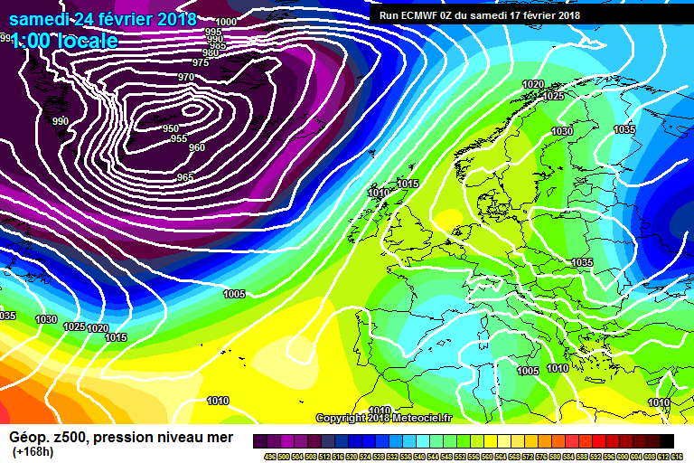
Yes, quite a big difference in the strength of the vortex lobe over Greenland; ECM has a 950mb super low, whereas ICON has a flabby and sloppy looking 990mb area!
-
13 minutes ago, feb1991blizzard said:
IF - and its a big if, it tracks further south (always a possibility), it could be another 18th Dec 2010 for you - I know your location got battered because there was an Ipswich town match on the day a late kick off and it was a blizzard - somehow the game got completed - I think.
Yes, Ipswich beat Leicester 3-0 and you couldn't tell where the white lines were on the pitch; amazing it got finished really.
I detest wind storms with every fibre of my being so I have everything crossed for lots of Southward corrections over the coming runs. Rather concerned that the 18Z takes it North again, there doesn't seem to be much of a consensus at all on its track at present. The UKMO isn't that interested in it at all (although I haven't seen the latest Fax charts) whereas the ECM and to a slightly lesser extent the GFS want to destroy the country with it!
-
1
-
-
Looks like that's probably it for today now here; been lucky really, it snowed for about 2 hours this morning giving a covering of about 4cm. Enough for a decent snowball fight with the kids anyway.
Hopefully the places that didn't get any today will soon do so in the days and weeks ahead; plenty of winter to go.


Model Output Discussion - Colder but how cold and for how long?
in Forecast Model Discussion
Posted
I’ve been looking through the precipitation charts for the coming weekend and see that, apart from over Northern hills, the breakdown is just going to involve rain. Could someone with more technical knowledge than me (that’s most on this thread ) tell me why, with all the cold air in place across the UK, it won’t involve at the very least a snow to rain event for all?