


NorthantsSnow
-
Posts
1,610 -
Joined
-
Last visited
Content Type
Forums
Blogs
Gallery
Events
Learn About Weather and Meteorology
Community guides
Posts posted by NorthantsSnow
-
-
I barely read the MOD thread this close to an event, so I wouldn't know. All the action is here in the regionals anyway.
Bed time for me, night gang. I'll check in before work around 6.30. Hoping for better news from the 00z, let's hope the 18z was worst case scenario and we see a swift backtrack!
-
one thing about the 18Z it is leaning towards more cold for next week
Yeah, for those jammy Spaniards especially. :lol:
I'm going to pray the pub run is having one of those nights. Can't get enthused by what it's showing at all.
T36 and at that time frame, it's pretty much identical to the NAE output....as these are hi-res outputs I'd go for them at this time frame IMHO
Fair enough, but they don't go out far enough yet to deduce whether or not it's a snow to rain event as per GFS 18z or snow all the way as per GFS 12z.
I think all models at least are agreed it will start off as snow, aren't they?
-
18z is dreadful. Big downgrade for whole region.
-
If everything is fine and dandy and the same tomorrow evening, that is when I get hyped up.
Especially as we can switch to the high-res models like the NMM and NAE then for greater accuracy.
-
Current output suggests yes
PS Ohhh I do love that word:

Ohh yes, that's what I'm talking about! Time to charge the cameras I think. :winky:
-
The NAE cuts off just at the point where it starts to get interesting! This is the final frame:
-
so am i right in assuming Northampton area could well be in a good position for a good pasting then? Please god, let it happen.... just this once.
Fingers crossed mate. I would say we are in a very good position indeed based on the CURRENT output. But boy oh boy have we been stung before, even this close to an event.
That said, the modelling of this has been more consistent than usual which is encouraging. And it's hard not to get excited by a run as peachy for this neck of the woods as the GFS.
We've been long overdue a dumping after last winter's disappointments, bring it on.
-
Models look a little better this evening. Sat night event well worth watching, definitely some potential there.
-
No surprise to hear that the GFS has bashfully retreated from its previous idea that it had run with for about 8 runs in a row. Seriously, why do people bother with this model? It's useless.
-
The model output tonight just confirms my view that this is going to be one of those close but no cigar scenarios. Shame, because that's a massive push of cold to our east trying to make inroads. But it isn't allowed to make enough progress for it to really make a mark and so the temperatures might be of more note during this rather curtailed spell of cold weather than any snowfall we might get. We should at last see some decent minima and maxima recorded throughout the region, a much needed reminder that we are actually in winter.
The UKMO called this one right all along I think and the weekend will bring milder conditions. Longer term, might we get another bite at the cherry? Maybe. Certain factors are working in our favour. But we'll see. If it can go wrong, it will. For now I'll be thankful for what we have, which isn't much from a snow lover's point-of-view, but it's a start, and continue to monitor the only model worth following the UKMO (along with the NAE and NMM in the shorter term for more accurate snowfall projection) for any further developments.
-
The Met Office has changed that update now, and added another yellow ice splodge to the warnings.
They are basically pulling back from the milder conditions, saying a rain band will move through turning to snow and ice on the leading edge and may get stalled by the cold.
Where you looking? It's still there on the warning page about the cold weather alert. See paragraph 2 here:
http://www.metoffice.gov.uk/weather/uk/coldweatheralert/
Sorry, but I'd never bet against the UKMO on this. For them to put that on their website suggests high confidence in that outcome.
-
Some potential up to Friday then, although with pressure so high on the western side of the United Kingdom the further east you are the better I'd say. I'd imagine the precip charts will upgrade as we get nearer the time (as they have done for today in the SE) as they pick up on on various features they miss at a longer range.
Beyond that, the UKMO update says it all: "Milder conditions are likely to arrive during Saturday and Saturday night, with temperatures likely to rise above threshold values in all regions."
They have complete faith in their model and so do I. The GFS is playing us again. Enjoy it whilst it lasts folks, I know I will. Let's hope we get organised bands of snow coming in off the N Sea Thurs/Fri, it's our best bet right now and a damn sight better than anything else this incredibly poor winter has had to offer us.
-
Drat. Just rain.
-
Gotta go bed unfortunately. I'll report back at 6.30am.
-
I wish I didn't have to work tomorrow! This could be good...
-
Look East: "Rain, sleet and snow, more likely across the 3 counties and Northamptonshire. Some accumulation through Friday."
-
Very few wet snowflakes near Evesham (about 115m above sea level). Only lasted 2 minutes now back to rain
Very good sign if it's turning a little wintry already. Thanks for the update.
-
I know we're supposed to be nowcasting now, but have you guys seen this yet? It's a thing of great beauty for us snow starved E'Midlanders...
-
I do think we could see some, But yes last winter was atrocious for us!!! we dont wont a repeat of that...
Absolutely not. Can't handle another winter chock-full of model teases that end up near misses!!
-
Northampton south enough but too far east I think. It's like last winter all over again!
-
Precipitation is heading fairly north.. not all is lost, the precip only needs to be 50miles east and 50miles north to give at least some of us a good covering according to NMM.
Indeed. In situations like this it will go right to the wire, so we shouldn't be too disheartened by the GFS output. I've known it to change right up to the actual event in setups like this.
-
I've obviously been living under a rock and missed all the buildup to this. Probably for the best if it goes the way of a pear at the last minute !
-
That was a pleasant surprise seeing all that white on the BBC 10.30 forecast. Probably old news but overnight Thu into Fri looking very interesting. NAE looks pretty good too, GFS less so.
-
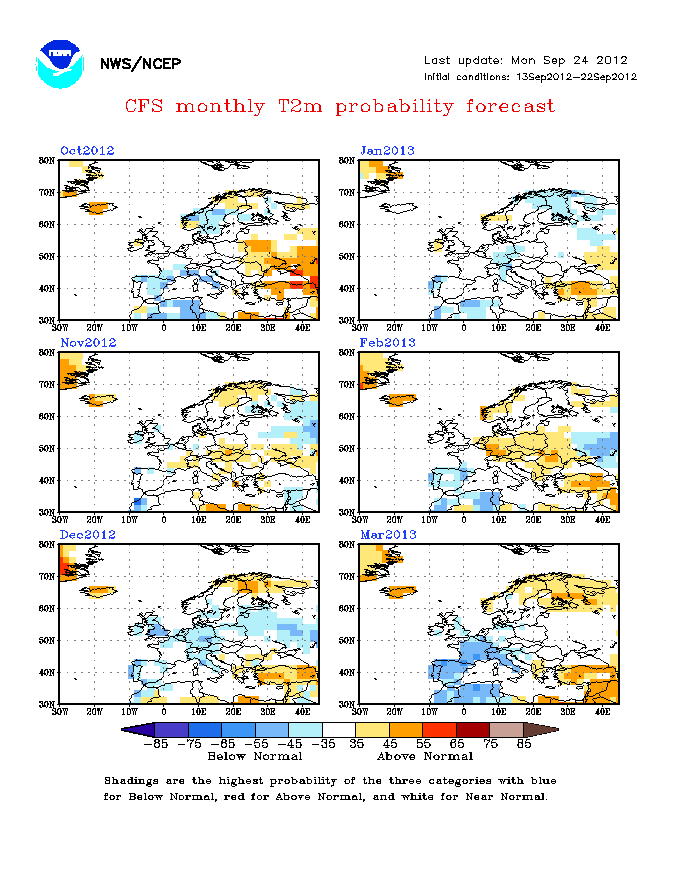
The CFS charts have gone a bit orange this morning!
Dreadful charts from the CFS. Winter looking to be a total non event for Europe if this is correct. So disappointed with this output.
For those saying it isn't very accurate I don't recall seeing it produce charts anything like that last year or the year before. It's hard to imagine it could be that wrong.


The Midlands Regional Discussion - Part 2
in Spring Weather Discussion
Posted
No change on the 00z. Pah!