
- Popular Post


Met4Cast
-
Posts
5,437 -
Joined
-
Last visited
-
Days Won
15
Content Type
Forums
Blogs
Gallery
Events
Learn About Weather and Meteorology
Community guides
Posts posted by Met4Cast
-
-
- Popular Post
- Popular Post
2 minutes ago, Severe Siberian icy blast said:Well a difficult read particularly when im learning alot again now and understanding things so much better but with that comes an obsession to read carefully every word because its part of my learning process but when i haven't got loads of time it really come up at wrong time for me but everything has been put on hold!!!
I need to understand the abbreviations used, gwo, glam, aam, annular mode. I understand the geography and science behind it but i need a better understanding on it all if im taking my journey seriously.
Any references greatly appreciated
Cheers
Shaun
GWO - Global Wind Oscillation
GLAAM - Global Atmospheric Angular Momentum
AAM - Atmospheric Angular Momentum
Annular mode - Essentially the Arctic Oscillation
-
 9
9
-
 4
4
-
 2
2
-
Just now, johnholmes said:
Is it me, perhaps I'm seeing something that is not correct?
Most avid followers seem in despair after each 00z GFS run, fairly elated then after almost each 06Z and 12Z runs?
There was a discussion a few weeks ago on this actually. The 00z runs appear to flatten the patterns more quickly only for the 06z and 12z runs to slowly re-amplify the pattern again.
Not sure if this is a genuine observation or just a bit of confirmational bias creeping in but it is something i've noticed over the years of model watching.
-
4
-
-
- Popular Post
- Popular Post
1 minute ago, Catacol said:Just ok??
 - it literally couldn't be any better though the gloss is taken off by the fact it is the CFS. I prefer the JMA monthly - that won't be too far away.
How about this from GLOSEA then..

-
38
-
- Popular Post
- Popular Post
11 minutes ago, Tamara said:Bom dia e todos

I make no apologies for yet again re-pasting this sequence originally posted just prior to New Year, because it has become an even more focused roadmap. Not just for the upcoming 10 day period, but indeed confidence increasing as a blue-print for well into the second half of the winter:
....................................................................................................................................................................................
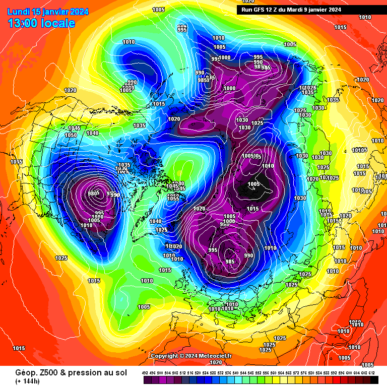
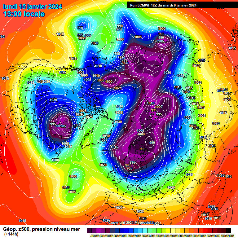
With the Nino attractor phases fully engaged, the amount of westerlies propagated into the atmospheric circulation between tropics & extra tropics do, as you suggest, indicate a higher floor to the angular momentum budget in the 'lull' ahead of the next upswing as the MJO traverses the tropics during January. GWO Phase 4 is a good medium base floor level I would think.
If we were to take a diagnostic template of GWO Phase 4 (and account for a likely return shallow orbit through phases 0,8 & back to 4) during an intermediate 'lull', then that very intermediate lull phase you describe will likely feature the return of a flat upper flow extending towards Europe.
The difference to recently though with the Atlantic forcing will be the jet suppressed further south - and with a cold pool established then attritional forcing of lows against the blocking likely to be a feature. (This accounts for some of the thinking as expressed within my previous posts in respect of the sub tropical jet)
With a cold pool established, any erosion from the south/west into NW Europe is likely to be attritional and not likely to displace cold pooling totally.
Taking into account we are still now in the lag period for the effect of +ve momentum from FT/MT mechanisms c/o the recent tropical>extra tropical cycle, we are seeing the new convective signal come into the Indian Ocean. Sea temp anomalies are supportive of deep thunderstorm convection. This, allied to convection in the western Pacific, will generate further mean zonal west wind anomalies to propagate across the tropics into the sub-tropics. With the westerly wind additions generated in December still in the atmospheric circulation, total and relative angular momentum will increase sending the GWO back into a (potential high amplitude) phase 5 orbit.
This progression & evolution suggests a strong -ve NAO with positive height anomalies shuffling between Greenland > Iceland and Scandinavia. Meantime southern Europe wet & mild under the sub tropical jetstream.
Muito obrigada. Melhores Cumprimentos

......................................................................................
To update the template of this analysis:
A very starkly high octane angular momentum budget is emerging and prolific within the global-wind-flow budgets. This translates to stockpile ammunition supply levels for deeply sustained poleward amplification eddies taking on veritable tanker sized reserves.
Based on how much tropospheric led influence there has been on the NH pattern in recent weeks since the starting pistol was fired to destabilise the polar profile, these further poleward swathes of +ve momentum transport take on especially egregiously gargantuan proportions for future wholesale instability and implosion across the polar field. In this respect it is not hard to comprehend the latest sentiments of Amy Butler and how she sees the synoptic pattern imprinted
The copied post referred to a baseline phase landing place for the Global Wind Oscillation. This baseline, ahead of the strongest wind-additions yet c/o eastward progressing high amplitude MJO wave back to the Pacific has remained higher than intermediate phase 4 (as discussed in the copied post)
The latest GWO phasing, even under present lull stopgap at very low amplitude 5/6, reflects the remaining considerably high levels of +AAM anomalies within the atmospheric circulation as aggregate total AAM. (Phase 4 GWO would be more suggestive of flatter return of the jet and greater attrition from the Atlantic against blocking. (Though even this sharpens somewhat against late Jan/early Feb wavelengths)
This GSDM wind flow budget situation is significant. More on this shortly.
The GWO is a phase plot depiction of aggregate wind-flow within both the tropics (MJO related) and the extra tropics as a measure of how efficiently propagation of wind-flow is proceeding between the tropics & extra tropics. This matters, because it is a barometer for synoptic pattern (poleward) amplification potential and provides a diagnostic towards directional flux of wind-flow eddies.
Poleward flux has now become quite supercharged
What of the significance of this?
As the intraseasonally driven MJO crosses the Maritimes at high amplitude, then very strong +ve torque mechanisms will be re-engaged to over top a system already awash with +AAM anomalies. The GWO likely to drill upwards into very high amplitude Phase 5/6. Taking into account maximum winter wavelengths, then this teleconnects ever more strongly to entrenched -ve NAO (under chaotic stratospheric diminution to spotweld a deeply -ve Annular Mode).
How can this be visualised?
The upcoming next cascade of westerly wind burst propagation into the extra tropics creates white water rafting within the sub tropical jet from the Equatorial Pacific downstream to the Atlantic -at the same time as the polar profile becomes riven with -ve mean zonal -ve wind anomalies. Defining solid roadblocks for southward directive of a deeply unstable thermal boundary.
How can this in turn be visualised?
With deeper upper cold air ensconced north of the polar boundary, this leads to feedbacks of entrenched surface cold with time to feed an ever starker thermal boundary, This encourages and emboldens larger progressions of numbers of kayaks slipstreaming below it. This translates to trains of low pressure undercuts - and it is not difficult to envisage the potential for high impact weather events to unfold in such a scenario.
The kayak posse delivers an "atmospheric river" of saturated sub tropical air and a large jump of temperature into the upper teens for my part of the world well below the thermal boundary at the same time as in contrast...
.... that is better left to the mercurial imaginations of any members who might be looking in from NW Europe.
Putting all this diagnostic analysis together, it is hard to see anything other than a tanked -ve Annular Mode relationship dominating much of the rest of the winter. However, and as ever, further analysis is wholly prudent to document how proceedings unfold.
Muito obrigada. Feliz quarta-feira

Well..
Bloody hell. This is probably the strongest wording I've seen you use in terms of cold & significant winter weather impact potential for NW Europe. In essence, teleconnections remain solid for -NAO and -AO throughout the rest of winter with likely repeated periods of high latitude blocking. The next MJO cycle progresses eastwards will see a return to strong +FT & +MT driving total AAM tendency upwards once again from an already high established Nino (+AAM) base state.
Myself and @Catacolhad noted that AAM tendency had bottomed out & returned to more neutral/positive values faster than anticipated, reading your post it seems you had expected a greater fall than observed too (GWO remaining above phase 4).
Thanks Tamara. As someone who is a lover of cold/snowy weather but also tries to remain balanced & unbiased in the context of the GSDM, for me, this is a very exciting update!!
Though of course, more regional (UK) based milage may vary, macro vs micro.
-
45
-
3
-
1
-
Unfortunately the GFS 06z det really goes off on one in the extended!
-
4
-
-
- Popular Post
- Popular Post
EXETER KEEP THE FAITH!
Extended update via app, they see the block & hold holding on into February!
-
25
-
6
-
2
-
2 minutes ago, Blizzard_of_Oz said:
Surely the Met office will likely issue yellow warnings of snow and ice from Monday morning, upgrading to amber and possibly red if reading from the present charts.
Can’t say I’m seeing anything worthy of a red being modelled for next week..
-
6
-
1
-
-
- Popular Post
- Popular Post
The GEFS mean are a substantial shift towards colder outcomes with far fewer milder members in the mix, I suspect many have followed the det in sending the lows south of the UK rather than into the UK. I mentioned we'd probably see something like this happen a few days ago.
Away from deterministic runs the day 5 means from the ECM & GFS are very similar. Cold northerly across the UK with snow showers/likely longer spells of snow from any disturbances.
Any widespread significant snow risk will depend on the track of the lows coming in from the west but honestly, don't be surprised to see these miss the UK entirely.
-
13
-
1
-
14 minutes ago, fromey said:
Can I assume the fax has some human input?
Yes, drawn up by the on duty chief forecaster I believe.
-
5
-
-
2 minutes ago, Rayth said:
Dear me
You are not wrong
Yup very, very good GEFS 06z suite..
If we can see the same from the EPS later today this place will be putting out the balloons.
-
6
-
1
-
-
- Popular Post
- Popular Post
Very, very good 06z. very very good day 4 FAX..
-
47
-
6
-
2
-
- Popular Post
- Popular Post
I can’t say I’m liking the overnight runs either.
We seem to be losing the more robust Greenland high signal & relying more and more on the low dropping into Scandinavia. There is no consistency between models. It’s not ECM/UKM vs other models it’s every model vs every model.
Pretty much impossible to see where we’re actually heading this morning.
-
18
-
1
-
- Popular Post
- Popular Post
-
Either MOGREPS, UKMO and the ECM/EPS all have this wrong and somehow the GFS det is correct despite the GEFS being a complete and utter mess with no discernible signal, or the GFS is just rather useless.
I know which camp I'm in. We'll see on the overnight runs, can't discount the GFS but the evidence is certainly against it.
-
8
-
-
GFS isn't having it.
Onto the overnight runs.
-
The bold green line is the GFS deterministic run that some people are looking at and calling winter over.
The rest of the lines are ensembles. Looking at the chart above the cold air hangs on across the UK until the very end of the run, the det whilst not an outlier has very little support. The UKMO was very good. GEM was good, the EPS are good, MOGREPS are good.
There is more evidence to support a decent cold spell vs against. Could that begin to change? Yes, of course, but currently, today, it hasn't.
Original post: https://community.netweather.tv/topic/99706-model-output-discussion-into-2024/?do=findComment&comment=5003643-
2
-
-
- Popular Post
- Popular Post
1 minute ago, Zero Visibility said:
Here we go, no bulge.
Well it is cold out..
-
12
-
Just now, northwestsnow said:
Oh I'm not sure about 120 EC..
I hope it doesn't go TU

It's not gone fully GFS but neither has it gone fully UKMO, seems to be a bit in the middle.
-
- Popular Post
- Popular Post
The bold green line is the GFS deterministic run that some people are looking at and calling winter over.
The rest of the lines are ensembles. Looking at the chart above the cold air hangs on across the UK until the very end of the run, the det whilst not an outlier has very little support. The UKMO was very good. GEM was good, the EPS are good, MOGREPS are good.
There is more evidence to support a decent cold spell vs against. Could that begin to change? Yes, of course, but currently, today, it hasn't.
-
22
-
3
-
4
-
- Popular Post
- Popular Post
-
- Popular Post
- Popular Post
This thread can be incredibly confusing at times, especially for those new/less knowledgable. I do wonder if much like the "Pro/Meteorologist" tag whether it might be worth a new tag for those who consistently & frequently post informative, non-biased balanced views to the forum, just as a reference point that what that person is saying can be "trusted"? It may help ease the confusion a little @Paul
Whilst the GFS deterministic run flops about like a fish out of water, the UKMO & to an extent GEM remain rather consistent. As @Tamarapointed out a few days ago the ensemble means will be next to useless in the extended due to a large amount of spread and an overall "smoothing out" of small-scale features.
I don't think the GFS deterministic is correct. I also don't think the UKMO is correct. BUT. Broadly, ensembles point towards cold conditions next week with a growing risk of high impact snowfall events as lows attempt to move in across the UK, this remains firmly routed within NWP modelling and is also consistent with the teleconnections.
“All models are wrong, but some are useful” – George Box
-
36
-
3
-
1
-
-
- Popular Post
- Popular Post
-
Just now, chris55 said:
That’s not the chief forecaster. It’s the guy who advises about whether warnings and how to stay warm etc, think he was previously in a different role.
They literally said he was the chief forecaster & that he is in charge of weather warnings, i.e the role of chief forecaster. He also does other stuff too though.
P.S. There is more than 1 'chief forecaster'.
-
1
-
1
-
1
-


Model Output Discussion - Colder but how cold and for how long?
in Forecast Model Discussion
Posted
There remains a marked divergence around the 17th within ensembles in regards to the track of the first low pressure system.
Milder members favour a more northerly track and hence temporarily bring in milder air whilst many members favour a more southerly track and hence keep the cold air in place across southern England. The GEFS in particular is awful at resolving undercutting & disrupted low pressure systems so it's not really a surprise to see the deterministic output wobbling about across the envelope of possibilities, this is why ensembles exist, to provide some much needed context.
MOGREPS 06z is more in favour of a southerly tracking low and for the most part keeps the colder air in place. At this range I'd favour MOGREPS over the GEFS, but the more northerly tracks can't be discounted yet.