


lorenzo
-
Posts
4,875 -
Joined
-
Last visited
-
Days Won
25
Content Type
Forums
Blogs
Gallery
Events
Learn About Weather and Meteorology
Community guides
Posts posted by lorenzo
-
-
Some notable low pressure systems from Feb 4th from Wetterzentrale archive.
1948 975 mb Iceland SE
1950 960 mb Iceland SW
1951 965 mb Ireland W
1957 960 mb Mid Atlantic
1960 975 mb UK N
1962 960 mb Iceland N
1964 970 mb Iceland NE
1966 975 mb mid Atlantic
1968 975 mb Iceland S
1970 975 mb Scandi
1972 965 mb Ireland W
1981 970 mb Norway
1988 980 mb Ireland
1989 955 mb Iceland
1990 950 mb Mid Atlantic
1994 955 mb Ireland
1999 970 mb Iceland
2008 970 mb UK NW
-
I think Mr Data posts a good question, also is the outlook on this forecast still for a milder second period in January ? Cold seems to be more persistent now.
Another point of interest is in the ' Better than the models' thread MB has posted a presentation re: a great Storm for early February. Would be interested to know you guys thoughts on this and how it fits in with what you see is on the table for the beginning of February.
-
GP here's to 2011 I hope that you still grace this place with your presence as the debate between now and the teleconnects heats up am sure your on point to deliver.
Keep seeing so many challenges to your synopisis - your the benchmark at the frontline of where forecasts can be - I congratulate that. ( dont see the METO mention AM or MJO at present ) they should hire both you and Chiono
Keep It rocking in 2011
-
If anyone would oblige what I am interested in now is how the MJO and GWO have influenced the Jet over the last decade and whether over the last two decades the last 3 years are seen as blips in the regular pattern.
Is this a La Nina irregularity as far as winter patterns are concerned or are we due a rest to ' pure La Nina' conditions.
It feels as if the models are nuancing towards the irregular.
I still want to know what forced, continually reinforced the blocking heights in December looking historically at this winter before moving into January and Feb !
http://www.cpc.ncep.noaa.gov/products/precip/CWlink/MJO/mjo.shtml
NOAA times out then loads on re-load , excuse the pun, on occasion.
-
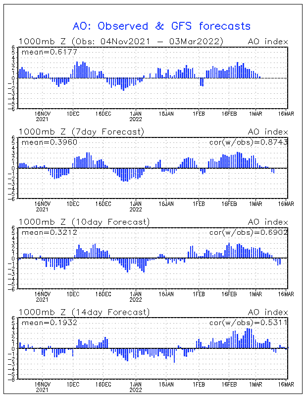
The outlooks for AO are tanking negative for at least a couple of runs.Sudden Stratospheric Warming - am I correct?

-
In all honesty am delighted that with my limited knowledge of weather that looking at QBO stats and thinking of sunspots in my drunken muse was actually written up in existing papers.
Only briefly read the first link I found but this is science in its infancy only 65 years of data and 3 sun cycles..
-
This German university is a fantastic place to start for all things stratospheric, QBO and sunspot related. Some excellent papers with here will give you plenty of the information you need and its all been peer reviewed!
http://www.geo.fu-be...nen/ge2000.html
If you can’t get the papers from this website google the authors name and you can often find them through there personal websites as below:
http://strat-www.met...in.de/labitzke/
Enjoy.
Thanks for the links - loads of papers in there to delve through.
-
Looking at this year vs last Sunspot activity has heralded a new age on our weather - I have no idea about verifying this.Is this accurate?
Looking at some random posts on other sites the Gulf Stream has placed us on a par with Moscow hence the cold -NAO some credence yet empirically is this the root cause of cold weather?
Latterly do we have or are we on the borders of de cellinization>?
Looking at the cycles of weather, ozone abuse has depleted - we are leaving greenhouse years and now the cold returns from our CFC Winters- how long wil this last?
Looking at our daily models ECM - wobbled, NCEP - GFS, predictions from Far FI., Its amazing role reversal from the consistent and reliable to erratic trend spotter.
Couple of things still remain...
Northern Blocking - why did this return so quickly? what caused it? was it expected? what caused the polar jet to meander?QBO? Stratospheric 'Perfect' Synopsis?
Atlantic influence NAO - when did it trend negative, where is gulf stream, why did this 'flip occur', where are we vs La Nina conditions.
I hope these questions reverberate with some on here - this simply is against the norm..
Apologies for posting in model thread - got bombed out of there - I did want however our real time expert views - I am not one please let me know if I am off the mark or if this summary of questioning is relevant.
For me in limited understanding I believe that 1 Stratospheric Influence is underplayed on models, OLR Rossby Waves and GAM is also underplayed perhaps not by ECm but by GFS, there are faults in 06z runs unquantified, this period of time has literally blown apart climate change xperts without reference to unquantifiable.
As I said i am new her but I do see the expert discussino of Chiono and GP providing with the 8-15 mb Noaa work as better guidance than GFS, NAEFS, ECM, NOGAPS<BOM ever can- they simply verify.
Anyone wishing to reply appreciated... I am sure this will resonate with folks not only interested in what the odd shortwave does to our wee island ...
-
QBO charts from ECMWF - first highlights October and the second is from 1957 to date - if anything this illustrates how far a deviation from the past 2 decades this winter has been.
-
With the last summary you gave and cooling it certainly looks like the reinforced blocking may ebb. January looking messier.
I was looking for a correlation between QBO and Volcanic Activity and found one paper released last year. Sorry lost link.
I guess there is no lead time for analysis into the impact of Iceland - although if not Iceland, then Solar Impact must be one of the contributing factors to increased blocking.
Other TC's are throwing up signals out of the norm also. AO vs La Nina
Thanks for the response, this is certainly a thread I will monitor as looking retrospectively I think right now your on the button for longer range
-
Chiono - thank you for this thread - fantastic summaries.
Am trying to get to the bottom of why blocking seemingly wants to establish again and again on the models and there is plenty to read in here to help me unravel this, summaries of the plots are superb. This December so far seems to challenge your opening post excerpt below, having limited knowledge of the mechanics of the QBO - do you think this has influenced the blocked pattern ?
This year the QBO is in a westerly phase. The westerly phase flows in the same direction as the polar vortex circulation which does nothing to inhibit the flow, and the BDC is also reduced in a westerly phase. Therefore this year the polar vortex is likely to be stronger than last and as a result high latitude blocking is less likely.
Now got some reading to do - http://www.agci.org/dB/PDFs/10S1_LGray_SolarInfluencesCLimate.pdf
-
1) Our blocking ridge centred over the Atlantic;
2) The ridge developing in response to the North American mountain torque (usptream amplification, troughing SE USA, increased upper flow across 40N);
3) A developing signal in the stratosphere for blocking.
http://www.cpc.noaa....re/10mb2525.gif
So perhaps the polar field is reacting to forcing mechanism around its edge - being pulled around by the middle latitude stratosphere ?
Looking ahead, the presence of the mid Atlantic ridge does look to be under estimated by the modelling and the troposheric signal should be for this to persist as a dominant factor over the next few weeks, particularly as the atmsophere is now fully La Nina like.
The modelling of the polar field is a tricky one and not reliable enough to base a solid forecast on, however the differentials between the tropics and around 60N is stark and may well be manifesting itself in anomalous downwelling and consequent tropospheric impacts (blocking). So for the time being, some credence to way the polar vortex is being pulled around right now by the models.
Weatherwise, the cold is almost certainly dropping out of the Arctic through Scandinavia and into central Europe. The key question remains in the medium and longer term is will it (deep cold) get far enough west with a dominant ridge in the Atlantic ?
Jua a quick edit - whats your own take on the models and how they are coping with the extra blocking signals GP, the above seems to temper SM post regarding decellinization.
Looking at MJO the convection signals from Indian Ocean last year for me had a 4-5 day lag effect into where we are and subsequently influenced the charts - tell me if am wrong this is a novices observation - OLR seems to me to have been heavy recently and without the other factors I am not expert in i.e torques / Angular Momentum it still seems that the blocking pattern wants to reinforce.
What in your opinion looking longer term has created this repeat GH blocking?
-
Hi there fellow weather fanatics. Can anyone give me a link to somewhere that resizes pictures, so i can post them for you all to see?
Thans Rob.
-
High pressure abound, crystal clear blue skies this morning and some fine sunshine.
Still very chilly though, not spring yet..
-
Steady snowfall for over an hour here now - brief moments of it getting quite heavy then easing off again.
Passing South West by the look of radar -should be some decent falls for the Borders within the hour.
-
Headline events in terms of intensity, interest and model watching blue army - not a long term prediction.
Am not citing a breakdown here just venturing that it seems to be where the majority of the energy is kicking up, agreed not Atlantic driven.
-
BBC News just now - Scottish ski centres have had more snow this week than the venues for the Winter Olympics in Canada.
-
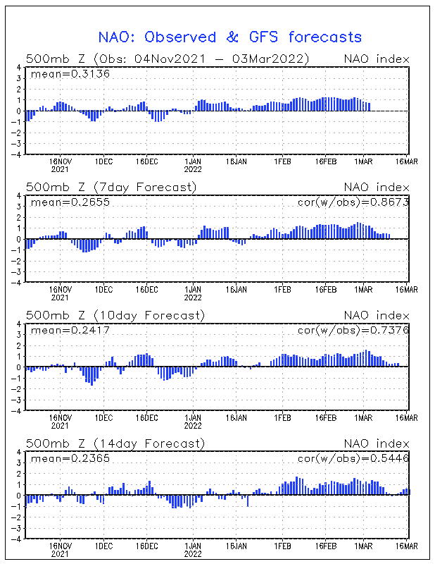
AO projected to go positive for the first time in a while within the fortnight, blink and you'll miss it.
NAO still in a negative position but only just, weakening as March begins.
MJO Firmly in stage 7.
A good animation of the 500mb preceeding our current position -giving no indication of any blocking establishing?
Next fortnight seems pretty unsettled, I reckon Atlantic Lows may be the headline events..
-
Rain on it's way out now as the DAM line sinks south, snow beginning to fall here and winds pushing from all directions it seems.
Looks like the next 24 hours will see even more. Brrr..
The Low in the North sea seems to be steadily moving north up the east coast of the country and it's outer edges moving onshore overnight, westward action as it meets the cold air flow from Scandi.
Some storm in the English channel over the next 48 hours - glad am not getting a ferry anywhere anytime soon! That low pressure system keeps it's energy all the way onto landfall and keeps on churning until about t96 over St Petersburg.
The Atlantic definitely picking up activity now. The North South divide in upper temps keeping us in among the cold stuff for a while yet - an Icelandic high projected for the start of next week hopefully keeping the remnants of that storm at bay and a couple of crystal clear blue sky winter days.
-
It is a truly disgusting grey morning, back garden is flooded, freezing rain and lots of it.
No fun at all..
North East in for another spectacular pasting today too.
Definitive winter for Scotland.
-
Just looking at radar and at the infamous lamp post out the back of the house - plenty of breeze and the first sporadic flakes beginning to fall as the northern edge of the front arrives.
Think it's going to be picture postcard stuff in the morning.
-
Currently -9c here this morning and the old farmhouses windows compltetely frozen up on the inside for the umpteenth time this winter. The growing cold feels like it is building up to a battleground blizzard of the past if the attempted warm up air attacks from the right direction regardless of what the models show.Given the the amount of change in the synoptics this winter I still feel a cold spring is on the cards with repeated wintry outbreaks delaying spring land work on the farm until mid April as in the sixties. Also hay, straw and silage are in short supply and prices are rising stteply , this almost guarantees a late spring.
This is a forecast I can trust - take note GFS you charlatan... :lol:
Tulloch Bridge showing -15 for 6 am this morning.
Come on PPN you know you want to arrive...
-
FFO - thanks for the reply - first time I had really thought to have a look through the Ensembles for MJO - I guess they are on the fringes of experimentation.
Interestingly the verification plots are way off point - so not sure really what to make of them. MJO FI ?!
The CPC should release their weekly update on ENSO today at some point, last update was +ve but weakening conditions remaining into summer. Possibly a revision up and coming?
Still perfectly poised in a land of confusion.
-
You should email that remember this chart to the Met Office LS.


Stratosphere Temperature Watch
in Spring Weather Discussion
Posted
TEITS - would appreciate if you expand on these comments for folks with less expertise than yourself and others on this thread, It would be good to see some charts or further illustration of what you are alluding to, especially if you are commenting on a pattern that is as recent as establishing over the last 3 years, this is an excellent development that everyone should be able to comment on.
Also - why are AO and NAO wrongly used - I dont understand, the indices predict patterns of whether, are they wrongly used because we are not seeing what is expected of them in a La Nina state?
In regards to JS - why has this occurred are there any factors which have invoked this change? Interested to hear your thoughts. TY