


❄️❄️❄️❄️❄️❄️❄️❄️❄️
-
Posts
2,643 -
Joined
-
Last visited
-
Days Won
1
Content Type
Forums
Blogs
Gallery
Events
Learn About Weather and Meteorology
Community guides
Posts posted by ❄️❄️❄️❄️❄️❄️❄️❄️❄️
-
-
ECM once again being a total block tease in FI.
-
 3
3
-
-
-
17 hours ago, knocker said:
Looks like a cold January

-
- Popular Post
- Popular Post
I think I know the most reliable model for tomorrow's possible snow event.
-
25
-
- Popular Post
- Popular Post
On 31/12/2015 at 3:06 PM, Steve Murr said:So to repeat what I just added over on TWO
bin all the GFS & ECM suites
1 hour ago, Steve Murr said:I think ignoring shortwaves and the ops in this setup is delusional.
I'm confused
-
10
-
Craig evans' guess was 0.7 under the actual outcome, that says it all.
-
1
-
-
20 minutes ago, I remember Atlantic 252 said:
Weak E'ly at 168, snowfest for NE on next frame 192
-
1
-
-
A few more westward corrections and we are in business!
-
-
-
Wait years for a decent Storm and 2 come along on consecutive nights!
-
1
-
-
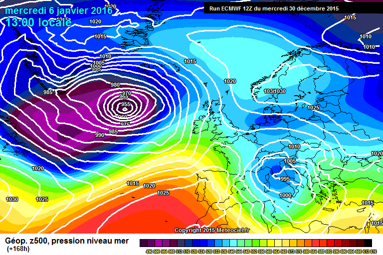
There will be a cross isobaric component to the flow (H->L), and also a general outflow from the high. So you might have a source from the Med, but this would be after that pattern persists for a few days.
Isobars are not trajectories and figuring out the trajectory of the air is not as straightforward as eyeballing one isobaric map.
OK Thanks for the answer. Still pretty mild for a few thousand metres up in winter, 0c isotherm at 3500m!
-
Does this show a Tropical Continental air source for the UK?
-
2.8C please.
-
1
-
-
I wish it was moving east!
-
Heck of a storm over Bristol, too far east here to even hear the thunder but plenty of lightning.
-
What is the mechanism that causes t-storms to build at night?
-
Phew what a scorcher!
Thinking of snow!
-
I wish!-3C Steady moderate powder snow
-
-
For those who are "enjoying" this late cold and snow please spare a thought for the thousands of animals that have been killed by this snow
I sure hope you didn't "enjoy" the 2003 heat wave when 70,00 people were killed.
-
Here we have sub -10 850s across almost the entire British Isles, and British Summer Time starts at the weekend!
And a blob of sub 5C SSTs east off Scotland!
-
The face over Scandinavia looks shocked at the cold!
-
No sorry. The air temperature will be affected by the Dewpoint value however, which is a broad representation of how dry the air is.
The other thing that affects the air temperature is snowcover. We might not have any but as we know the north and east of us do so with the air coming over the snowfields of the north and east of the UK to us, then this is also making it much colder.
Ah that would explain it


South West & Central Southern England Regional Discussion 11/1/2017 ---->
in Regional
Posted
A few bits of sleet and the easterly looks dead. Roll on summer.