


Evening thunder
-
Posts
4,874 -
Joined
-
Days Won
1
Content Type
Forums
Blogs
Gallery
Events
Learn About Weather and Meteorology
Community guides
Posts posted by Evening thunder
-
-
Seen a fair bit of discussion about max temps today, more in the MOD thread but I think my post is more appropriate to here.
I Must admit, I'd be surprised if we see 37C+ on Friday. 850hpa temps are 17C on GFS & ECM and Last Friday they were 20-21C.
Also, ECM has 950hpa temps of ~26C (windy.com).. last July for example they were 31C.
All recent record/near record temps I have remembered have had a difference of near 17 or 18C from 850hpa to the surface. Even with a long build-up like 2003.
August 3rd 1990, had a 19C difference with 37.1C reached from 18C 850's.
So I suppose if we see a 19C difference, and 850hpa temps are 18C.. we may get 37C.. though I think 35C's a reasonable bet, maybe 36C.
I've noticed Met Office forecasts for places with weather stations seem to be adjusted a bit higher compared to surroundings.. but Heathrow has a surprisingly high uplift of about 5C in forecast maxima considering surrounding towns such as Staines, Hounslow etc which are forecast 32/33C. -
Friday the apparently 'locked in' hot day is looking sketchy for some, ECM has a band of cloud here and 21C in the afternoon.
Although it is hot for most of lowland England.I don't think you can say there hasn't been any change/drift in the models.. well unless this thread's impression on previous days of a prolonged, widespread or record breaking heatwave coming was a bit off
It's not a bad outlook, just again a little disappointing if you wanted something notable away from the SE.
6 minutes ago, Djdazzle said:GFS 6z wants to brIng back the heat next week it seems.
Must admit I don't really see it on the temp charts unless you live in the SE. A lot of thundery activity on this run though.
-
 4
4
-
-
I think in part they underestimated so much due to pushing the plume though a little faster than reality and/or bringing in some cloud sooner (GFS did have a 34C on the day). I remember the GFS used to under-estimate more with a breeze than light winds.. not sure if that's still the case.
Of course 850hpa doesn't always translate easily to the surface, but I feel there is a realistic maximum increase of about 18C.. so some of the thoughts on potential temps next week may have been a touch high, but maybe last night's ECM could have squeezed 38C as it brought had the 20C line back.
2020, 2019, 2015 had a ~17C difference.. 2006 and 2003 maybe 18C.
Most extreme was perhaps 1990 when Cheltnham got 37.1C with ~18C 850's, so a 19C difference.
I suspect there could have been a 20C difference in 1976 given perfect conditions.. Well, more according to Wetterzentrale archives.. but I don't completely trust the available charts for back then anymore since I know they used to show ~17C 850hpa air 27th/28th June, yet now show 13-14C
So the former is a 18-19C difference again for the June record of 35.6C.-
1
-
-
From my point of view, I'm happy with the ECM. Thought it might have continued the acceleration towards barely a hot day here (Friday hardly gets the 15C 850hpa line in here on the GFS). However it's done the opposite.
Many runs yesterday had Saturday only hot in the SE so were only ever '3 hot days' if you were in the E/SE. However this run is better for the SW and W, who have often had to sit and watch talk of 'hot/very hot days' in the E/SE as if it's affecting the whole country.
Better for potential longevity too.
An easterly undercut would disappointing especially further east.. what happened to those 'hot easterlies' we used to occasionally get?
36 minutes ago, Mr Frost said:Friday 12:00 and 15:00
Edit: this shows why I didn't like the trend on many other models. Friday, what looked the most locked in hot day for many is only 'very warm' (or cooler further north) if you're not SE of a line from roughly Lincolnshire to Southampton.
Hopefully the ECM is right in some form in that the hot airmass backs west again, but perhaps with a lighter easterly at the surface.
Not that the weather wouldn't be lovely in the mid 20's, but my interest in weather is over-riding what I'd find most comfortable, after all on this side of the country we've had nothing notable from the 'record breaking' plumes that central-eastern areas have seen in the last 5 years.-
1
-
-
Looks like an increasing trend to a SE/E biased plume/heat event again to me (all 3 'record breaking' plumes in the last 5 years gave nothing notable to the west or SW).
I'm less confident of anything notable down my way through the weekend, though widespread high temps on Friday seem a safer bet.
It's not necessarily very hot away from the SE/E though, can't see any upgrade over what the 00z/06z models showed
-
1
-
-
An IMBY post here.
Yesterday was a very warm and humid day, Tmax 27.2C in my garden (may be 0.5-1C over). Exeter Airport saw 28.2C.
For interest's sake, it would be nice if one of these 'record breaking' plumes would affect the SW more.
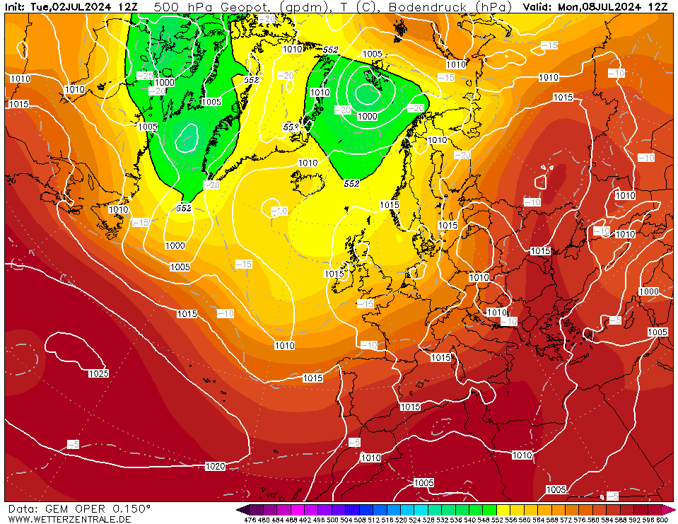
Sometimes we look sort of included on 850hpa temps.. but on 950hpa temps, we're not.. yesterday 15:00 (4pm BST):
Down into the teens though we had 26C at 950mb in South Devon in the early hours.
Last July was even more stark, 15:00 and 21:00
Look at that for luck.. Also the fact that at 9pm 950hpa temps >30C had travelled a few hundred miles over the N Sea, shows the English Channel wouldn't have that much effect, it's just the plumes have mainly been east of here.
It was the same story again in 2015.
Of course being a few miles from the south coast, I may not get that much hotter.. but the 'modified layer' would be shallow so maybe it would heat up quicker. Certainly further inland would be hotter, it's been a while since we've seen something like 1990's 35C in North Devon.
Interestingly Exeter Airport's temperature records (since 1973) go:
1976: 33.5C
1990: 32.4C
1983: 32.2C
2003: 31C (only a rounded figure available)
2013: 30.8C
2018: 30.6CA few years ago I put a trendline over the highest maxima for all years, and there was actually was a downward trend.
Seems in contrast to the SE, parts of the SW are actually overdue notable heat? A trend to plumes favouring the SE doesn't favour here.-
5
-
-
This study from the Met Office has a graph which suggests we've reached about a 1 in 100 chance of 40C in the current climate (so may well happen in our lifetimes even if global warming paused), which of course increases going forward.
https://www.metoffice.gov.uk/about-us/press-office/news/weather-and-climate/2020/chances-of-40c-days-in-the-uk-increasing-due-to-human-influence -
Probably the only summer I'd rate 'poor' overall from 2013-2019 here.
June was alright. Slightly sunnier than average.July was slightly cooler, duller, and wetter than average.
August was cooler, dull and very wet, with just 3 days exceeding 22C (two reached 24C) and 155mm of rain.
It's also the only summer in my records (2008-present) to not reach 25C here, more surprising considering the then July record going at Heathrow!
Highest was 24.7C on the 30th June. Cloud, onshore breeze, and the plume shifting east of here meant the 1st July reached 24.5C.
It was 23.8C around 3am though.. and a station just up the road/hill from me recorded its highest temperature of the entire year at 3am!!!
-
Well this clump of rain further north than expected has stopped any chances here so far (while anything with interesting heaviness misses here). Sounds very familiar to the only day in that June convective spell where I had a chance, only for a rain band to be much further south and scupper it.
Question is, will the clearance coming into Cornwall lead to developments? Looking very quiet currently. -
58 minutes ago, Wynter said:
The fact that the phrase "I don't understand why people like..." is one of the the most used on this forum is quite telling.
All you need to understand is that everyone is different and everyone is entitled to like whatever they want. Questioning someone's preferences, especially in the derogatory way that some people do on this forum, is pointless and annoying.
I agree, it's surprising how often people seem to apparently be offended by other people's weather preferences.
-
2
-
-
16 hours ago, Sunny76 said:
Looks like a nice area. Where is this?
I love having a long country or coastline walk.
This is between Beer and Branscombe in East Devon. One of my favourite parts of the coast around here.
Sea breeze was a bit stronger yesterday and 19-20C right on the coast but hopefully not too chilly. 20C at 8:30pm at my location as the sea breeze died which was quite pleasant.
A nice enough morning today, more cloud and maybe showery bits of rain coming in though. -
Hopefully holiday makers are happy enough with the weather down here so far this week. Low 20's and sunny or sunny spells.
This was yesterday, warm enough for shorts and t-shirt especially doing a walk like this.
Felt hot enough in the sun.. I'd like some 'warm evenings' weather but that would probably mean it's a bit hot to do walks like this in the day (for me at least), so swings and roundabouts.
Looking at the satellite image today.. looks poor away from the south again though.
-
4
-
-
We had 4.6C on the 11th July here, 6.3C yesterday and 5.3C today.
Although I live in Devon 3 miles from the coast, we're almost on the floodplain of a river valley so get cool nights all year.
In contrast, a weather station 300m from the coast in Sidmouth, and less than 3 miles from me, had a low of 12.7C last night, and the lowest they've had this month is 10.7C.
The lowest I've recorded in July (2008-present) is 3.7C on the 31st July 2015. Most July's get a minimum of 6-7C, although in 2018 the lowest was 8.8C. -
4 hours ago, Scorcher said:
You have to laugh at this chart- the Northern Hemisphere is exceptionally warm for the most part at the moment- yet virtually the coolest air in the whole hemisphere is close to or over the UK- including many areas of north of the Arctic Circle.
You could argue that we couldn't be any more unlucky right now. Even extremely cold places such as Novaya Zemyla which is well inside the Arctic Circle have noticeably warmer air than the UK at the moment.
Almost posted yesterday, that 850hpa temperatures looked warmer over the North Pole than the UK for today.. then I thought I'd better not.
Nice day at the surface down here though, 21-22C and mostly sunny.-
2
-
-
2 hours ago, B87 said:
I've also asked this before, but why is the UK the only country on Earth where this is the case? Electronic sensors in France, Poland and NZ (and probably more locations, but I haven't looked at reports for those) all report increases 10-15% in sun hours recorded, some with ridiculous measurements. Paris for example, which like London averages 212 hours in July, seems to frequently record over 250-300 hours of sun in July now, and 200-300 hours extra over the course of the year. Paris is not noticeably sunnier than London.
CS vs KZ study from Poland, 10.4% increase with the KZ:
A comparison of sunshine duration records from the Campbell-Stokes sun
LINK.SPRINGER.COMThe purpose of this paper is to compare daily sunshine duration data measured using a Campbell-Stokes sunshine recorder (CS)...Not sure, but there's studies for example of 16 UK sites where both CS and KZ recorders were used simultaneously, that show the relationship for the UK:
https://rmets.onlinelibrary.wiley.com/doi/10.1002/wea.2288
https://rmets.onlinelibrary.wiley.com/doi/abs/10.1256/wea.99.03
Surely there must have be a difference in instrumentation or methods between the UK and other locations you mention, either before they changed from CS to KZ or after?
Either that, or the 'cloud climate' of the UK really is anomalously different to these other places (even France and New Zealand?), for example if we get a lot more 'broken' cloud that reverses the relationship for us. -
First time I've probably stayed up to look for it when it's clear. Can see it with my naked eye and it looks good through my binoculars. Seems I may have missed it looking better though..
Also have just discovered I can make out 4 of Jupiter's moons through my binoculars!-
3
-
-
4 minutes ago, Sunny76 said:
Exactly my argument.
My day trip to broadstairs was partly spoiled on Monday, despite the weather being sunny and cloudy with temps of 23-25, the wind made it feel chilly. It was from a northerly direction. That’s not the kind of breeze I want in summer.
Tbh those temperatures would be at least slightly above average for any coastal location in the UK, and if there's not a significant breeze anyway, you will usually get a sea breeze develop. Although don't think I've ever felt chilly in 23-25C, so maybe one had developed and brought the local temperature down a bit.
-
1
-
-
1 hour ago, Sunny76 said:
Some people on here are lapping this god awful weather up. I have no idea how anyone in their right mind enjoys this crap fest of weather, when we have to endure this during the autumn, and winter months. Plus, this is far more boring and tedious than a continuous spell of sunny dry weather.
Just a thought, maybe people could be allowed to like whatever weather they wish? After all, it doesn't effect the actual weather...
A better day here today, 23C and sunny.-
1
-
-
8 minutes ago, Djdazzle said:
And there are models showing rubbish at the same time frame. Extended outlook also looking poor. ECM goes downhill rapidly after 144. If the charts you post have more support in the morning then all the better.
A bit cool on the 'lesser two' of the top performing models I suppose
ECM, UKMO, GFS, GEM
ECM still alright for most at T+192
I agree the summer's been a bit poor so far, and I understand the frustration.
However there's some settled charts in the output, my next 7 days forecast on the Met Office is no rain, low 20's, and decent sunny spells. I guess that's not a total crap fest.
Unless people are just talking about the unreliable day 9+ timeframe, I guess..-
4
-
-
Yeah.. it's a total crap fest on the 12z's...
I'm sure the expectations and criteria for no moaning get worse each year-
2
-
-
24 minutes ago, MATT
 said:
said:
Yes Ive got the message now.. The conditions are poor.. But just a thought guys, wouldn't some of these persistent posts be better suited to the moans thread..
I agree there, and the Met Office bashing that broke out earlier because the outlook or models don't show what people want (if that's suited to any thread on this forum)
-
2
-
-
1 hour ago, B87 said:
It's only 21.9c here for the first 12 days of the month. Even with the next 2 weeks slightly warmer than average, it only gets up to 23.1c by 26th. We will need a heatwave in the final week for this month to end up near the 81-10 or 91-20 average.
23.0c is the limit of what I find an acceptable July here while still being below average. Any lower, and sunshine would need to increase drastically. We don't get cool and sunny summer months here though (eg 22c with 230+ hours).
I'd say 23.1C was quite near the 1981-2010 average if the very warmest stations have 23.5C as the average.
1 hour ago, B87 said:The whole summer, since 1st June? That is shocking.
At least it's not 2012 which had 3 days over 20C by this point here.
We get far less days over 25C here at my near-coastal location. It can be just a few a year, or in 2015, none!! I'd like more ideally but it can't be a deal breaker as the SW is the most popular UK 'staycation' area.-
1
-
-
Is this really the worst summer people can remember in places like Yorkshire and Hampshire i.e. worse than 2012?
I suppose the weather can vary a lot around the country.. however here 2012 gave 186mm of rain in June, then 74mm in 24 hours on the 6-7th July with severe flooding, and a max of 14.2C (I was in Holland with 27C and sunshine ironically).
In 2012, a whopping 3 days had exceeded 20C by this date, and only by the 23rd July, did that rise above 4 days.
June 2012 mean max: 17.4C
This year, 13 days above 20C so far, 4 above 25C. 96mm in June, 7.8mm so far in July.
June 2020 mean max: 19.9C.
Not amazing but much better than 2012 here. -
It's not been quite as bad down here, for example to the south of the weather front and in the lee of Dartmoor the last 3 days have seen maxima of 20.5C, 21.9C, and 20.3C. Although I was in North Devon yesterday where the weather was worse.
Rather cloudy though, and a humid feel.
All maxima since 18th June have been over 18C. However, if this is the flavour of summer as a whole it would be the first one I'd call 'poor' overall here since 2015 and then 2012.
It kind of feels later in the year than it really is to me. Due to early Autumn (or recent August) like weather recently, but also probably due to all the dry sunny weather in Spring and the grass going brown in May, then lush green in June.
The past two years have had some brown grass in July (more so in 2018 of course but July 2019 was a good month here), then green in August.


Summer 2020 - Moans, Ramps & Chat
in Spring Weather Discussion
Posted · Edited by Evening thunder
That's true, if the airmass is slightly hotter, of course the maximum may be slightly higher.
Another thing I forgot to mention, I feel like last Friday's large under-estimate may have in part been due to the models predicting more cloud arriving sooner or slightly faster movement of the plume? (UKV from the day before had modelled elevated showers/storms in southern areas in the afternoon, and on the day the GFS 12z had upped temps to 34C) I also noticed a couple years ago the GFS seemed to under-estimate more in breezy conditions than light winds. Not sure how much that is currently the case but I think there was a reasonable breeze on Friday.
Yes but surely that would mean higher 850's as well? We do seem to be seeing more incidences of the 20C isotherm making these shores.
I'm just saying that although 850hpa doesn't always translate easily to the surface, a think a realistic maximum difference to expect in a heatwave is ~18C and I don't think it will be different this time just because.
Happy to eat humble pie though. I'm possibly being a bit pedantic over 1-2C.. I wonder if Saturday could see the highest temp now.. and that makes sense about human input.