


weatherjunkie
-
Posts
55 -
Joined
-
Last visited
Content Type
Forums
Blogs
Gallery
Events
Learn About Weather and Meteorology
Community guides
Posts posted by weatherjunkie
-
-
Third round of warming showing up now.

The timeframe of these repeated warmings could possibly lead to a prolonged spell of blocking right through to March.
The GFS 100 hPa chart forecasts show very little change still suggesting reducing Scandi trough whilst forming Atlantic trough drifts west towards Canada.
Wouldn't that signal a +NAO in the future? Or is this still one of those elephant trunk tornado scenarios?
-
Initial warming is occuring over Siberia as the vortex stretches to almost breaking point, but how long will it remain there is a key question?
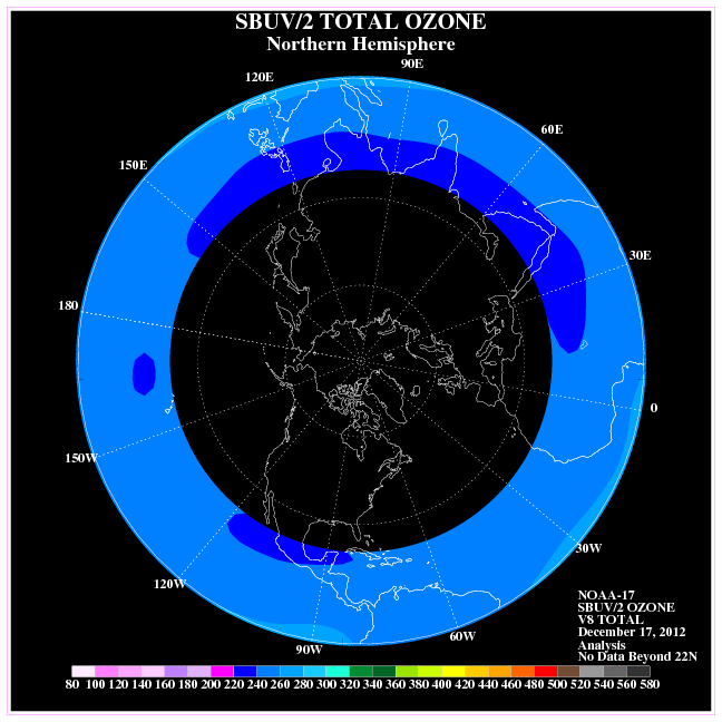
If we look at stratospheric ozone concentrations, we can see that the core build up is towards the Canadian Arctic and western Greenland, as it has been all winter largely:
http://www.cpc.ncep....7_nh_latest.gif
upper tropospheric and stratospheric temperatures largely tie in with ozone concs., so perhaps we should see the warmth now being generated tranfer readily across Greenland towards Canada. Interestingly, blocking in this locale has the support of tropical forcing centred east of the Dateline.
Strong west based -NAO?
Looks like the eastern US will be fair game starting around the third and lasting for quite a while.
GL to you guys in Europe. I hope the second half of winter provides snow for all.
-
0z GEFS NAO Outlook
Similar to the 18z run, and a little more robust than the 12z run.
-
This should probably go into the other model thread, but I thought some would enjoy it with all the talk of going back into the icebox.
18z GEFS NAO Outlook
12z similar but not as robust around the 2/6-2/12 time period. It gets as high as -0.4 SD around the 3rd and then dips to around -2.25 SD on the 10th.
-
hi weatherjunkie,
what does the NAO outlook have to do with the stratosphere?
Karyo
Nothing much. I thought that the graphic would be something people would like to see given predictions about high lat blocking in late Jan-mid February.
-
I eas expecting to see loads of posts and analysis here today?
Surely, things are looking good!
http://strat-www.met...t=temps&alert=1
Karyo
0z GEFS NAO Outlook
Predominately east based.
-
12z GEFS NAO outlook
It is predominately west based though, which I have no problem with in the U.S
. Keep the stratospheric updates coming. They are much appreciated.
-
Today's AO chart.
-
AyO this looks interesting (please excuse my poor pun). Perhaps another situation where the troposphere counteracts the stratosphere? Or will this change to reflect the strengthening vort and positive mean zonal winds downward propagation?
-
Exactly BF, and this is the third split this winter that has extended from the troposphere into the lower stratosphere!
Any concerns regarding the positive zonal winds propagating downward?
-
Having looked at the model runs and corresponding upper stratospheric temperatures I am still cautious, and will probably remain so for a few days, over whether a MMW is about to occur. It is still too early to judge the extent and propagation of the warming and subsequent disruption on the stratospheric vortex. What we know so far is that a warming is forecast to occur at the upper levels and is forecast to propagate down to the 10 hPa level.
One of the winters that I highlighted last autumn that could be quite similar stratospherically was 1986/87. This was an El Nino, -QBO, low solar winter similar to this one. During that winter there was a displacement MMW (23rd January) that followed a period of Atlantic blocking similar to the period that we are currently experiencing.
With that in mind it is worth viewing the MMW from that year to see if there are any similarities to the emerging pattern this year. Previous MMW's can be viewed at the following site by clicking on view events and generating the page using the geopotential height option:
http://www.appmath.c.../ssws/index.php
There was strong wave number 1 component to that MMW and there is a similar surge in heat flux for the current wave 1 forecast.
February 1987 had a CET of 3.6ºC and after a mild start was cooler thereafter. Interestingly March was a very cold month that year.
c
I'll take whatever we can get if it produces a weaker and displaced vortex and hopefully renewed potential for high latitude blocking.
Wave 1 tends to give a shifted vortex while wave 2 is more likely to give a split vortex. As GP correctly identifies the MJO pattern can produce planetary waves which disrupt the vortex, but so can high pressure systems situated in the north atlantic. At the moment I am not so keen on the vortex position forecast but looking at where the cold air is at 1hPa then I think the game may be on. In essence I think the ECM model does not have an accurate handle on what will happen at the moment.
It is worth remembering that cold air in the stratosphere is often associated with potential vorticity, which in turn is linked to low pressure systems in the troposphere. In other words I would prefer the vortex and cold stratospheric air to be shifted away from us for a cold outlook.
Looks like a +NAO and neutral AO from the images you posted and based on what I think you're trying to say.
It likes like from those images that there also appears to be potential for -PNA and some ridging along the eastern US. Ew...
Thank you both for the continued input.
OT: Does anyone know of a website that contains the GME model and its prediction for North America?
-
Hi weatherjunkie,
I agree with you that the strengthening stratospheric vortex is likely to affect the troposphere but probably not until the end of January unless we see some kind of warming in the meantime.
I highlighted yesterday that the GFS was showing the first signs of warming at the 10 hPa level and have checked the Berlin site today for evidence that this may be backed up. What I am looking for is evidence of a strong warming that could be classified as a MMW but it may take some time for this to become apparent.
There is the first signs that something may be occurring when one looks at the zonal winds at the 1 hPa level. There is the first signs of a dramatic reduction.
When one compares this reduction to last year's MMW then one can see that a similar thing occurred then.
So now it is time to see what is happening at the 1 hPa level at T+240 to cause this drop in zonal winds.
And lo behold we see a 20ºC rise in temperature within a couple of days. Furthermore there is evidence that this is forecast at the 5 hPa level. Encouraging signs but that is all at present.
So what could be causing this upper level warming? Perhaps it is an increase in wave 1 activity which is consistent with an Atlantic blocking based precursor.
My own thoughts all along have been with something like this occurring so I will be watching with interest.
c
Thank you for the reply.
I also see heat fluxation at 30hPa that coincide with the slowing down of the winds. That appears to be a good sign as well, but it's probably expected given what's happening.
The ECM seems to want to weaken the wave 2 activity in the upper stratosphere and "downwell" it to the lower stratosphere as it propogates poleward, do you have any thoughts about this?
Your input is greatly appreciated and here's hoping the GFS hops onto the warming trend and hopefully the ECM will too.
-
It's a bit early to get me shouting out just yet ,T! However, it will be good if the ECM picks up on this tomorrow
The warm November stratosphere has helped set up the pattern for winter so far,but this is likely to come to an end unless we get another warm push from the stratosphere. So far we have seen 'upwelling' stratosphere disturbances originating from the troposphere. The December cold spell and the projected one now have both come from vortex splits that have originated from the troposphere, so it would be interesting to see what would occur from an upper stratosphere led disturbance. Of course it is too early to say where this warming is heading but it is a good sign to see.
c
I wish a happy, healthy, and wealthy new year to all.
In reference to the bolded, is the stratosphere likely to play an important role down the road given how significantly low the -AO is? To me it appears that the troposphere will not be seriously affected by the potential strengthening stratospheric vortex in the next 1 to 2 weeks. There are signs that both the -NAO and -AO will lose their grip a bit, but would you expect a pattern reversal come the latter half of January?
I've seen Don Sutherland's post on Eastern which had the mean composite chart for when the AO reached -6 SD, but I'm curious to know how the stratosphere looked in year's with a similar -AO, and whether or not the stratosphere will be much of a factor.
Here in the US, the active subtropical jet and combined forces of strong -AO and -NAO has many people in the eastern third of the country in love with the pattern and reflecting back to how it compares to the 70s. I would love for this to continue and to hear some good news related to the stratosphere.
I guess it's a mostly wait and see situation.
-
MT spiking earlier this month to +4 SD. It has since come back down a bit to +2 SD and it appears to be continuing it's decline at a fairly decent pace. There is word on the street that would could see another spike. I would imagine that this would somehow play a role regarding the PV splitting, even if it's minimal.
-
It might be worth noting that mountain torques have gone from nearly -4 SD to +3 SD in a relatively short period. This may well be manifesting itself in terms of the stratospheric profile.
So there's potential to see more warming?
-
A comparison of total ozone concentrations over mid November during the last decade provides some illuminating insight into how we stand right now and why we are very much better placed to resist the usual drop in stratospheric temperatures as we head into December.
Ozone concentrations more or less translate to stratospheric temperatures, the more ozone the warmer the air and greater the geopotential height anomaly. Also, we need to look at the concentration of ozone over the tropics as less ozone there indicates enhanced Brewer Dobson Circulation activity and a weaker thermal gradient across the hemisphere (weaker polar westerlies - weaker polar vortex).
Current:
2008:
2007:
2006:
(no data for 2005)
2004:
2003:
2002: (1st December)
2001:
2002 and 2004 were the closest matches but in both years the tropical stratosphere concentrations were much greater.
With the tropical stratosphere cooling again, this should strengthen ozone concentrations over the Arctic into late December.
A couple of things are very evident looking at these comparisons:
1) The polar vortex will be weaker than any other winter this decade.
2) The position of the ozone concentration has been consistently building over the Pacific. These drift east over time. This means that the most likely place for the warming (and tropospheric impacts) look like starting over the Canadan Arctic and migrating eastwards towards Greenland with a trough over Scandinavia and western Russia.
Hope that knee improves Ed.
Delicious
Thanks for the update.
On a side note, I wish you a speed recovery Chi, and I appreciate the information you have given to me.
-
Oh my thats NOT what i was hoping to see in the run up to winter.
Word on the street is that the ONI trimonthly peak for NDJ may reach the strong category. Sub-surface indicates continued warming under Nino 3. and 3.4. With the upcoming MJO expected to move into a favorable location for Nino strengthening, I think an ONI peak for NDJ that qualifies as strong won't be out of the question (+1.7C).
-
Yes, it seems very reasonable. My wondering was somewhat rhetorical though - it was more a supposition that the recent MT events were having an influence on the stratosphere. However, it does bring us to another discussion point - that is - in an easterly QBO where the stratospheric vortex is already reduced, will any deflected planetary wave have a greater impact, and have more of an effect than they would ordinarily do so in a westerly QBO with a stronger vortex? I think so, but it is still early in the season and we have yet to see how the vortex will be affected later in the season, when it is stronger.
c
Oh I see
I also believe that there is a greater impact with an easterly QBO.
Only time will tell though.
-
I wonder is this linked to the fluctuating mountain torques.
I believe this should answer your question.
One type of atmospheric wave that exists is called the Rossby wave. Named for Carl G. Rossby, an early atmospheric research scientist, the Rossby wave exists due to a combination of meridional temperature gradients and the rotation of the planet (which produces the Coriolis force). The Rossby wave is a large-scale wave system whose size is thousands of kilometers in the horizontal and several kilometers in the vertical. Large-scale topographical features, like the Rocky Mountains and the Himalaya-Tibet complex, together with the meridional temperature gradients and Coriolis deflection, create a variation of Rossby waves called standing planetary waves. These have very long wavelengths (up to 10,000 kilometers) and either remain stationary or move slowly westward (i.e., they move easterly). They eventually propagate vertically into the stratosphere.When a standing planetary wave reaches the stratosphere, it deposits its easterly momentum, decelerating the westerly wintertime stratospheric jet stream. This is the polar night jet we discussed in section 2.4.2-c and depicted in Figure 6.02. The polar night jet slows and can even be displaced, which has the effect of displacing the polar vortex region.
The deposition of easterly momentum into the polar stratosphere and the deceleration of the polar night jet is known as "wave breaking" (see section 4.1.2). It produces the phenomenon of the stratospheric sudden warming (see Chapter 2, section 4.2.2) as warmer middle latitude and even tropical air intrudes into the geographic polar region. This result is a situation that is thermodynamically imbalanced. Wintertime radiational cooling in the polar stratosphere quickly begins.
Basically when the Mountain torque tanked it indicated that Rossby Wave Dispersion was taking place in the mid-latitudes in the N. Hemisphere. The Rossby wave eventually propagated into the stratosphere (may still be propagating into the stratosphere), decelerated the westerly jet stream, and allowed for stratospheric warming to take place.
I believe the reason that both Asia and N. America are seeing the strongest warming is because both areas had Mountain Torques that dropped rapidly below -1 standard deviations multiple times.
Seems reasonable no?
-
Sub-surface shows cooler water creeping in. With the MJO expected to be stuck in phase 3 for quite some time and perhaps retrograde back into phase 2, I think the easterlies in the W Pac should upwell cooler waters in the western Nino regions. Even a phase 4 of the MJO would result in a similar regression of ENSO SSTA. I suppose this would be mother nature's way of evening things out after the Kelvin Wave.
If one was to look at the NOAA/NESDIS charts, it's clear that the PDO has become more negative. Warmer waters near Japan and south of the Aleutian Straits. Cooler waters hugging N. America.
Here's what we generally get to look forward to assuming the MJO remains in phase 3 for the next week or so, and since the signal is weakening and easterly winds are somewhat decent, why wouldn't it take a while to propagate east?
-
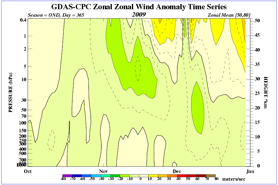
I would look in three areas. Firstly, the zonal mean wind anomalies to see if any negative anomalies are filtering down to the troposphere.
http://www.cpc.ncep....OND_NH_2009.gif
Secondly, the geopotential height forecasts at all levels of the stratosphere right down to the troposphere to see the shape of the vortex at all levels.
http://strat-www.met...n/diagnostics?1
http://www.cpc.ncep....strat_a_f/#emct
From these it may be possible to work out where tropospheric blocking may occur and see if it correlates.
Well, I've taken a look at some of the temperatures and geopotential heights at 10hpa , 30 hpa, and 50hpa and it looks like to me that that there is potential for high pressure to build near or to the west of Greenland and low pressure over the NE Atlantic in the long term.
Taking a look at the 100hpa level, it looks like high pressure will build into eastern Europe, low pressure over the northeast Atlantic and central/eastern Europe.
MJO is in phase 3 and is sort of expected to lollygag in that octant in the week or so. After that a possible jump to phases 7/8 is possible.
Combining those things, would a reasonable forecast for the next 1-2 weeks be a +NAO with a wet western/northern Europe with some reprieve as the MJO is in a favorable phase for dryness? After that in weeks 3-4, a -ve NAO and continued wetness into eastern/northern Europe with some dryness as MJO phases 7/8 by December would favor such a pattern?
Thank you all for your input. I'm tring to get a feel for all things named "stratosphere".
Hi
Didn't see your post till now, but ch has answered your questions pretty well anyway
Lates update suggests the current above average trend still sustained. It looks like mountain torques judging from the 'snaking' line date and forecast map pattern.
As ch says, there is a chance that this could effect the pattern for us by months end with some 'obliging' downwelling. A progression of the MJO by this time would also be most useful!
As others have said looking at the 10hpa and 30hpa temperatures and pressure tells you more about 3 weeks to a months time than the immediate future. 100hpa temperatures and more importantly potential vorticity at low levels in the straosphere can give some indications of where blocking might occur in the near future.
Blue areas on these chart indicate a bias (quite often shifted by tropospheric influences) towards higher pressure in my opinion.
During novemeber the stratospheric vortex typically starts over russia, so no surprises that is where it is now. What is interesting is that it is forming a little late and not moving north towards the pole as quickly as it does in some years(this shows up as warmer than normal stratospheric temperatures at upper levels). We should remeber that a warming is actually a displacement of the stratospheric vortex away from the pole or a splitting of the vortex). For me this alters the timing (christmas or just after now) of a transition period when the vortex moves north and the UK can expect a brief spell of cold.
Read GP's ideas about the brewer dobson circulation and why late formation and a weak vortex are to be expected and notice also where ozone concentration is highest in the northern hemisphere which explains why the vortex typically starts over russia. Still all to play for especially with a somewhat weak vortex currently.
Thank you for the clarification and information.
-
I would look in three areas. Firstly, the zonal mean wind anomalies to see if any negative anomalies are filtering down to the troposphere.
http://www.cpc.ncep....OND_NH_2009.gif
Secondly, the geopotential height forecasts at all levels of the stratosphere right down to the troposphere to see the shape of the vortex at all levels.
http://strat-www.met...n/diagnostics?1
http://www.cpc.ncep....strat_a_f/#emct
From these it may be possible to work out where tropospheric blocking may occur and see if it correlates.
Thank you.
-
I am not quite sure what you mean!! (what pattern?)
Canadian Warmings are normally quite weak affairs and as far as we are concerned they are good at reducing the net vortex strength. I have looked at length for papers implicating signifiacnt tropospheric impacts but have yet to find any.
The pattern I was referring to was the Western US ridging and Central and Eastern US troughing. It was my belief that stratospheric warming occuring in Western Canada would favor such a pattern.
The response you gave to me was:
I would say that depends upon how and if the upper stratospheric profile transmits down to the troposphere. If it does encourage blocking it may not favour it directly below the Canadian stratosphere.What am I to look for with the troposphere profiles in order to see if there is transmission from the stratosphere to favor the blocking?
-
I would say that depends upon how and if the upper stratospheric profile transmits down to the troposphere. If it does encourage blocking it may not favour it directly below the Canadian stratosphere. Imagine an elephant trunk tornado - landfall does not always occur directly underneath the area of wall cloud from where the tornado is generated. The same may be true of the stratosphere.
What sort of things should I be looking for to produce the pattern?
I appreciate the help.


 .
.


Stratosphere Temperature Watch 2011/2012
in Spring Weather Discussion
Posted
What would some signs be of wave breaking? I know we have to look at geopotential waves 1 and 2, but what other sources can we look at to determine the possibility of wave breaking?