


Nick F
-
Posts
9,891 -
Joined
-
Days Won
18
Content Type
Forums
Blogs
Gallery
Events
Learn About Weather and Meteorology
Community guides
Posts posted by Nick F
-
-
- Popular Post
- Popular Post
5 minutes ago, TSNWK said:Hello, is there something nagging you on what is currently being progged? That leads you to keep the champagne on ice

Not for now, we have a lot of consistency from models and their ensemble guidance which is a plus, but been burnt too many times at that range!
-
 14
14
-
- Popular Post
- Popular Post
2 minutes ago, Bricriu said:Yes. In future runs that low to the south west could be a spoiler for instance. I am going to try and contain my excitement for now .
It's like children in a candy shop who've been told by the owner they can help themselves to as many sweets as they want in here.
Sugar rush over day 10+ charts showing deep cold and snow.
Maybe after watching and discussing the models for 20+ years I've got a bit weary of the excitement of cold and snowy nirvana past day 7.
I'll join in when it's still showing below 7 days.
-
34
-
 2
2
-
 3
3
-
- Popular Post
- Popular Post
I'm not getting too excited yet, we are still talking day 10 and the -10C line is arriving across northern Scotland on 12z GFS. A lot can change before then, though granted the models are being consistent!
-
17
-
1
-
1
-
Well, Greece and Turkey get in on the deep cold before we do on 12z GFS


-
6
-
1
-
1
-
-
Oh dear, the annual comparisons to 62/63 being uttered.
Got my tin hat ready in case it goes Pete Tong
But not often you see such a strong +height anomaly over Greenland at T+300, as below on 12z EPS
Same time Europe in the freezer looking at T2m mean anomaly
NOAA CPC 8-14 day heights look similar
Original post: https://community.netweather.tv/topic/99706-model-output-discussion-into-2024/?do=findComment&comment=4994151-
2
-
-
- Popular Post
- Popular Post
Oh dear, the annual comparisons to 62/63 being uttered.
Got my tin hat ready in case it goes Pete Tong
But not often you see such a strong +height anomaly over Greenland at T+300, as below on 12z EPS
Same time Europe in the freezer looking at T2m mean anomaly
NOAA CPC 8-14 day heights look similar
-
17
-
4
-
3
-
- Popular Post
- Popular Post
Going against my wisdom to look too far ahead, but @Mike Poole analogy of a nice starter next week, but the mains to follow could be even better ...
-
13
-
- Popular Post
- Popular Post
1 minute ago, Battleground Snow said:That will come, by 120.
@Jason M there have been examples of decent falls even under higher pressure,.
Somebody posted the examples the other day of this, but I forgot who it was
It often snows with high pressure at the surface, so long as there is not a strong ridge aloft with subsidence, just need cold air advection over relatively warm sea (eg North Sea) to produce thick enough cloud for flurries / showers. SE / E England best chance for some flurries / showers with deeper cold air advection and lower heights closer to the upper low over the near continent.

-
8
-
2
-
- Popular Post
- Popular Post
8 minutes ago, Mike Poole said:Yes, I’m not sure what the cheering is about, we don’t want to lose the main course for the sake of a better starter.
What if there is only one course on offer, any subsequent courses may not leave the kitchen, too far out to know for sure
Cheeky little streamer for our SE contingent on Monday on ICON.
-
17
-
2
-
1
-
7 minutes ago, Met4Cast said:
Given this mornings 06z GFS and now the 12z ICON i think the trend towards something wintry in the E/SE day 4 into 5 is beginning to grow.
Yes, still far enough out for some 'upgrades' to cold into early next week. Can't imagine the models have an accurate handle on the position of the developing high - given the upper trough still has to dig into Europe later this week then disrupt into a cutoff upper and surface low over the Med over the weekend for the high to build.
12z ICON could be a more extreme solution for cold air advection, but can't rule out this depth of cold
-
4
-
-
UK Severe Convective & Storm Forecast - Issued 2023-12-30 09:45:57Valid: 30/12/2023 0900 - 31/12/2023 0600Click here for the full forecast
SEVERE CONVECTIVE WATCH - SAT 30TH DEC 2023-
2
-
-
- Popular Post
- Popular Post
Good to see a deep Genoa Low on the GFS, always a good omen for coldies, though it's not in the reliable yet.
-
14
-
-
00z EPS have trended a little colder than the 12z run yesterday. GEFS seem much less enthusiastic in any colder trend. Lets hope EC is leading us the right way!
12z yesterday 00z today
-
6
-
-
- Popular Post
- Popular Post
00z EPS H500 and T850 mean anomaly at day 10 will please coldies
-
19
-
2
-
- Popular Post
- Popular Post
Not really until into the 2nd week of Jan does the 12z EPS mean get all the UK cold / below average temps. But it has been looking like that the last few days anyway, jet doesn't get far enough south to bring the cold to all before then.
Patience as always, fingers crossed it's not another false dawn like the late Dec promise that failed in the end. This time the trop drivers are lining up more favourably for the right pattern change, even without a SSW.
-
13
-
2
-
1
-
- Popular Post
- Popular Post
11 minutes ago, Lukesluckybunch said:Watching those Iberian heights at day 10 ..could be the spoiler like on the ECM
I'm not the only one concerned that the jet stream struggles to get far enough south in recent winters, because of the sub-trop high pressure belt expanded northwards, even when high lat blocking is signalled. It hampers cold air getting further south than Scotland. Lets hope we get a greater push south of high latitude blocking in January, as at the mo it's not coming into reliable.timeframes. Always beyond 7-10 days.
-
14
-
- Popular Post
- Popular Post
Trend GIF for last 4 EC high res runs for 12z 1st Jan show the shift south overnight of the jet stream & consequently track of lows towards NW Europe for 1st few days of New Year. That wedge of +ve heights suddenly appears to the SE of Greenland on 00z run:
-
14
-
1
-
- Popular Post
- Popular Post
Quite a big change from the models for the 1st few days of the New Year, was looking rather mild with long-draw SWly winds, but the models this morning have pulled the jet stream further south, with that low moving up from the Azores underneath that wedge of +heights over the far North Atlantic. Something stirring ...
-
18
-
12z UKMO offers up a 'wedge of hope' this time next week, with wedge of high pressure building to the NE on back of low moving SE into near continent pulling in cold air briefly
Probably won't be continued though!
-
5
-
-
Blog looking at the increasing probability from weather models for a Sudden Stratospheric Warming in early January, which could bring colder and wintry weather, especially if there is a split in the polar vortex following the SSW.
-
The stratospheric polar vortex is currently displaced towards northern Europe and has brought very cold temperatures in the stratosphere above the UK and Ireland, leading to nacreous clouds which have been sighted as far south as Kent.
-
6
-
-
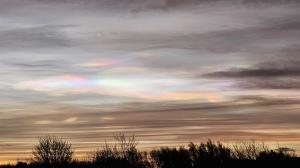
Got some nacreous cloud here in Caterham-on-the-hill in Surrey
 Not seen them this far south before.
-
7
-
-
Yes, I've recently become unconvinced by the whole solar min = cold winters / solar max = mild winter idea. So much so, I didn't include it in my current winter forecast for Netweather.
Jan/Feb 1979 was very cold and snowy, yet there was a solar cycle max that year, albeit in December. Winter 1968-69 had cold Dec and Feb (Feb had CET of 1C) despite solar max in Nov 1968. Then we had solar min on Dec 2019 - look how that winter turned out. Winters of 1974-75 and 1975-76 were mild, despite a solar min in March 1976.
There are mentions out there over the years that just after a solar min is when colder winters are more likely, like 2009-10 / 2010-11. But it doesn't stack up for other solar cycles.
Back to the models, at least it doesn't look too mild on Xmas Day on 12z EC, especially up north in the strong NWly:
Original post: https://community.netweather.tv/topic/99584-model-output-discussion-into-winter/?do=findComment&comment=4980323-
1
-
1
-


.png.8921493a777cbbb193df7e71853c0848.png)
Model discussion highlights
in Forecast Model Discussion
Posted
It's like children in a candy shop who've been told by the owner they can help themselves to as many sweets as they want in here.
Sugar rush over day 10+ charts showing deep cold and snow.
Maybe after watching and discussing the models for 20+ years I've got a bit weary of the excitement of cold and snowy nirvana past day 7.
I'll join in when it's still showing below 7 days.
Original post: https://community.netweather.tv/topic/99706-model-output-discussion-into-2024/?do=findComment&comment=4994977