


staplehurst
-
Posts
855 -
Joined
-
Last visited
-
Days Won
1
Content Type
Forums
Blogs
Gallery
Events
Learn About Weather and Meteorology
Community guides
Posts posted by staplehurst
-
-
12z EURO4 representing the storm activity reasonably well thus far - just a shame it's not available earlier in the afternoon!
However, it is still, alongside it's 00z and 06z counterparts, producing a lot of rain over London, Surrey, NW Kent and parts of Essex at the end of the night into first thing tomorrow morning - and given it's persistence this should probably be taken more seriously now that there could be some notable impacts in these areas for the morning commute etc...

-
 1
1
-
-
1 minute ago, ajpoolshark said:
hmm, going by the euro4 and chatter on other forums, the focus for storms seems to be adjusting towards SE counties as opposed to the west country as predicted on the overnight runs....I'm now rather less optimistic from an IMBY perspective, too far west I fear
Agreed - latest high res models (UKV and EURO4) continue the trend to nudge things further SE, broadly in a zone where we see the wind convergence right now, i.e. Swanage NE-wards to Medway. This would still place some parts of Dorset at risk, but would put more of the Home Counties and London within the 'zone of potential'. Of bigger concern might be the impacts from thunderstorms that develop later in the night over London and SE England which could have some notable impacts on the morning commute, for example. Treated with a low probability in any one specific place for now, but certainly something to keep an eye on...
-
16 minutes ago, Nick F said:
Interesting chart from Metdesk posted on twitter:
... ties in with the ECMWF rainfall charts:
That'll be the 00z EURO4 that MetDesk have tweeted there. Whereabouts are those ECMWF charts from Nick?
-
2 minutes ago, Weather-history said:
Models have been struggling the last couple of day until it has been right on top of it. Thunderstorm development yesterday was underestimated going off Monday's info.
No one in the Greater Manchester area expected to see one of the best storms of recent times going off Monday's forecasts.
Depends where you source your information from though - a Slight chance of Severe thunderstorms that talks about the potential for hail 3-4cm and "any storms that do develop on Tuesday ... will produce quite frequent lightning" suggests that somewhere might get a decent storm?
-
1 minute ago, CreweCold said:
Pretty poor if you ask me. Even taking a basic projection based on the radar at time of initiation would have yielded better results...
and this is a perfect candidate for why it is not realistically possible to give site-specific forecasts of exactly where and when thunderstorms will occur, especially when they originate from the mid-levels - because at the end of the day, forecast apps etc are driven by models and if models can't capture things correctly and/or struggle with plume events, then they will offer little use in these particular setups. Ingredients-based methods works better, whilst trying to spot trends amongst various NWP output.
Problem with GFS is it's a coarse-resolution global model - it's never going to capture every single thunderstorm, because they are much smaller in size than the grid spacing of this model. And sadly the GFS hasn't been particularly useful in many of the plume events over recent weeks. Certainly a blend of ECMWF and EURO4/UKV offers the best guidance - not perfect, but generally a lot better than the GFS. But most free apps are run off the GFS (or WRF / NMM derivatives that use the GFS for their boundary/initialisation conditions).
-
2
-
-
Despite the intense thunderstorms in parts of England last Saturday, August 2016 overall was a pretty quiet month for thunder (as most of us know ha!)...
-
3 minutes ago, Mesoscale said:
I don't think so, we are a bit too far East/South East for this one I think.
6 minutes ago, Flash bang flash bang etc said:I'm wondering if the south east is gonna get some evening imports
There is a suggestion that as the upper trough approaches from the Atlantic and engages with the low/mid-level high WBPT plume then there could be some elevated convection this evening spawned over the eastern English Channel and running NE across C/E Kent into the North Sea - the western extent of coverage still uncertain, as is often the case.
-
2 minutes ago, PerfectStorm said:
Seems like the updated forecasts were pretty much all wrong today.
How on earth do you come to that conclusion? From what I can see, given the huge amount of uncertainty, it's actually gone quite to plan...
-
1 minute ago, ajpoolshark said:
i'm such a saddo....sat here under the garden umbrella, yet still soaking wet, desperately trying to keep the laptop dry whilst still posting, and taking in all thst mother nature can throw at me
I don't blame you at all - I wish I was there to witness it too ha!
Dry, quite sunny in Norwich but quite a blustery easterly wind, fuelling the storms out west and southwest.
-
3 minutes ago, Windblade said:
Once again absolutely cloudless skies in every direction with zero convection and still very hot. I cant see anything happening in the next few hours.
Well nothing's forecast to happen until post-midnight anyway
-
- Popular Post
2 hours ago, Surrey said:Where is William Grimsley!!!
He's been telling a different UK weather forum about the altocumulus castellanus over Devon for the past few days
-
10
-
5 minutes ago, dave48 said:
In the absence of any other specific forecasts for the UK yesterday, and with estofex giving a no risk area, you played that very well, a superb forecast on a day with just about as much uncertainty as you can find.
Thanks Dave - mid-level plumes and the like are always fraught with uncertainties, but this particular spell feels moreso than 'average'. Hard also trying to gauge which bits of precip could turn thundery - wasn't overly-sold on the outer frontal wave type feature (that ran over the Midlands in the early hours) being thundery, hence kept the SLGT over the narrow corridor where lightning seemed more likely from elevated thunderstorms. Coverage didn't look great enough to upgrade to MDT, hence the comment in the forecast text about it not being as active as the 19-20 July event.
Today is not really any more clear-cut. General idea being the risk of TS activity increases later today and into this evening/tonight, but as to where, how active will lightning be, will we develop a supercell with large hail? A lot of uncertainty, but the potential is there for sure!
-
9 minutes ago, Speedway Slider said:
We're there any lightning strikes over west/east midlands, east anglia from that large mass of heavy rain that moved north east over the country overnight?
Not inc the storm that's exited the east coast over the last half hour or so...?
Not sure if I dreamt this storm, or it was real!!! (Leicester) between 03:30 and 08:00 this morning!
This is 7am yesterday to 7am this morning… (lightning are the black dots)
-
4
-
-
2 minutes ago, chrisbell-nottheweatherman said:
Evening Dan - seems that my post in the regional thread was totally incorrect. As yiu say, the low cloud fron the North Sea ledto a disappointing end to a hot and sunny day with some lovely cirrus clouds here a few miles south of yourlocation. I must admit we missed thelocal forecast this evening - friends came over - did you do it?
Depends on your preference - I for one am thankful for the noticeable cool northerly breeze!
and it's Alex today - I'm back on Friday...
-
Mist and low cloud rolled well-inland from the North Sea in Norwich this evening, so after a max of 29C this afternoon we've been sitting at 17C with a dew point of 17C all evening, and a cloud base lit orange by the city lights at 100ft above the ground! Just seen a few flashes lightning up all this mist above our heads with a long, deep but quiet rumble.
-
3 minutes ago, Flash bang flash bang etc said:
I know it's the typical pathetic result we in the south get despite dramatic temperatures all day.
i can understand why *some* posters are disappointed and want something big to happen. By rights it should, but there's always a bloody catch. If it was 100 miles further in any direction we would be looking at dramatic supercell storms. It happens all the time so I'm not just being bitter or making stuff up.
thanks Nick for your clarification of the situation. Literally the first I've heard of there not being something more than a few pulse storms on the cards, I was under the impression we were facing a destabilisation. Obviously not now and I stand corrected.
sorry if some people on here though I was getting ahead of myself - I wasn't - I was merely going by the vague forecasts I had seen and heard over the last 48 hours.
tomorrow it looks like the Midlands 'turn'. Bet you they get severe storms. What a waste of heat.
This is a destabilisation occurring through this evening and overnight, hence the reason why there are showery outbreaks of rain developing and running NE-wards, with some embedded lightning on the eastern fringes at times. I'm yet to read any written forecast that suggested anything livelier than that?
http://www.convectiveweather.co.uk/forecast.php?date=2016-08-24
-
38 minutes ago, Flash bang flash bang etc said:
Can someone please enlighten me as to what missing ingredient we're short of this time? Massive area of heavy rain peters out as it hits hot unstable landmass. This simply can't be science - we have heat, instability and a trigger. Why is nothing kicking off?
edit: the landmass isn't unstable, the air is (I think)
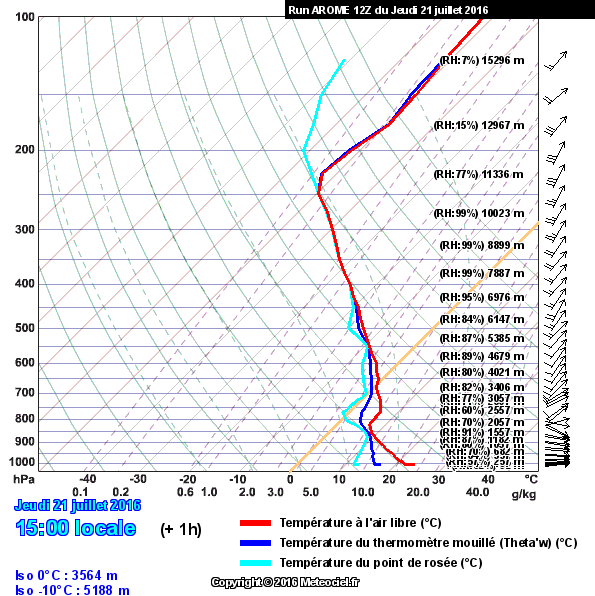
First, the Herstmonceux (East Sussex) 12z sounding reveals a hot and quite dry airmass across the SE today, and even adjusting for a surface temperature of 33.8C (which was the highest achieved today in the UK at Cavendish in Suffolk) still does not break the cap, even though it gives a tasty 2,200 J/kg SBCAPE. Capped in fairly substantially to surface convection today!
However, as we have seen with the medium level activity spreading up from Biscay and Brest, the 12z Camborne (Cornwall) sounding looks more unstable and also very moist in the medium levels, atop quite a warm but dry low-level airmass - so as we have seen with some subtle upper forcing, elevated convection has brought showery bursts of rain and the odd thunderstorm, but this falling through a lot of dry air so probably no more than some large convective drops that don't amount to much in the rain gauge - at least at first, until things moisten-up further through the night.
I suspect we'll see a continuation of this theme overnight until better upper forcing arrives, especially late in the night into tomorrow morning.
-
2
-
-
8 minutes ago, Nouska said:
You can get projected soundings for different parts of the UK on Meteociel - just look for the sondages from GFS, WRF, AROME or ARPEGE. ARP gives UK wide view for clicking on location.
http://www.meteociel.fr/modeles/sondage_arpege.php?region=uk&ech=3&mode=2&wrf=0
Choose petit emagramme to give a clearer view.
12Z run sounding for London.
Thanks - a useful site to have. Although forecast soundings will be limited by how many vertical levels are available in each model, but nonetheless are a useful tool - and in this case, plotting a projected Normand's Construction would also suggest any rising parcel would reach the capping inversion at approx 775mb.
-
26 minutes ago, Flash bang flash bang etc said:
Southern England have some showers too! Or has everyone forgotten about us
Still think there is room for some sparks down our way despite nobody mentioning it anywhere.
Could someone explain the mechanisms at work today inhibiting thundery activity around London if poss?
The sky is milky grey with very high level cloud but it does look a little stormy to me
Frustratingly there are very few 12z soundings available for the UK, but if we take the Larkhill ascent from this afternoon and adjust the surface temperature to 25C with a dewpoint of 12C (which seems reasonable for the London area this afternoon etc), you can see that there is some convective potential, but it becomes capped off around 750mb (or approx 2.5km above the ground) due to warmer layers above - in fact it becomes even more capped off at 700mb (3km up), thus severely limiting the potential depth of convection.
Farther north, I suspect this capping in the mid-levels is slightly weaker, allowing parcels to achieve greater heights, but still capped off to a certain extent and hence the presence of some heavy showers over Merseyside recently, but with next to no lightning - it's not totally out of the question, but it's quite a low potential today.
-
2
-
-
50 minutes ago, Windblade said:
Tell me about it. The best places are definitely out in the sticks where there is less traffic and better views with less tall buildings in the way. The Usa is tempting though, not just for the ease of chasing, but the nature of their weather is much more severe so theres a lot more to see generally.
What I will say is, though, once you go to America you'll be hooked and want to go again and again - my first was in 2012, but I've been back every year since, and no sooner have I landed back in the UK after each trip that I'm already looking forward to the following year...
-
2
-
-
5 minutes ago, SP1986 said:
They don't anymore as far as I was aware?
Yes, Met Office are still the providers for BBC Weather. Nothing has been announced publicly (to my knowledge) as to who the next provider will be, though.
-
1
-
-
1 minute ago, P-M said:
Cheers Mate - I seen the current one with the MDT areas before the update though? Then they released an update at 7.55am to say they'd tweaked the areas slightly and added text but I can't see any tweaks to the MDT / SVR areas?
Small tweaks were made to the SVR to extend it farther north across Scotland, the MDT was also extended a little bit more over NW England, and the SLGT was shrunk from E Ireland.
-
2 hours ago, ajpoolshark said:
really?.....maybe for your immediate locale, but on the whole, it's been very active with a rash of pulse-type thunderstorms over many parts of the UK & Eire......the shear amount of posts on here give a less than subtle clue...lol.........of course, it could be a conspiracy of monumental proportions and that all the hundreds and hundreds of posts have been bogus (1050 an still rising since friday) and the lightning detectors have been rigged by NW to get NWx subscriptions
30 minutes ago, Flash bang flash bang etc said:Are the storms diurnally driven today? I'm just thinking it's likely that most activity will start to fade now - I don't think today has anything in store for us so eyes to tomo but I really don't expect a lot to happen. One little storm would be nice tho, even just some mammatus or some wind
Largely diurnally driven, but areas of forcing will keep bands of showery precipitation going overnight, albeit with a much reduced thunder/lightning risk until diurnal heating recommences tomorrow morning. Most likely areas to see further showery bursts overnight are over the Cheshire Plain, West Midlands and down towards Glocs/Wiltshire and perhaps Hampshire way.
Incidentally, there were a few lightning strikes detected just ESE of Godalming around lunchtime earlier on today - here's the lightning strikes detected so far since this forecast period started (7am BST) through until now, which I guess would satisfy the forecast of a slight (30-45%) chance of lightning within a 25 mile radius...
-
3
-
-
27 minutes ago, William Grimsley said:
@staplehurst, are you guys going to be issuing a warning for us later?
Hi William,
They're seen as more 'forecasts' than 'warnings' per se - we leave that to the Met Office. Right now I'm currently in Wichita KS so my colleague Chris is looking after things while I'm chasing state-side, not sure what his availability is like with shifts etc.
-
2
-


Convective Storm/Discussion thread - 02/09/16 onwards
in Storms & Severe Weather
Posted
Agreed - although wouldn't be surprised if Norfolk didn't see much in the way of lightning at all. Going to be a real mess tomorrow, plenty of convective rain around but sceptical as to how much lightning there will be...