
- Popular Post


staplehurst
-
Posts
855 -
Joined
-
Last visited
-
Days Won
1
Content Type
Forums
Blogs
Gallery
Events
Learn About Weather and Meteorology
Community guides
Posts posted by staplehurst
-
-
5 minutes ago, Convective said:
Somewhere is going to get a storm tonight. If not these parts, north of here should get something. Things destabilising quickly now. These photos taken over the last 15 minutes:

That's the plan
Anywhere from Cumbria / IoM north into southern then central Scotland.
-
 2
2
-
-
35 minutes ago, Harry said:
Love that thunder map. Absolutely true for my location! Albeit I didn’t have one storm move overhead (excluding Wednesday where I suppose technically the rain very much did come overhead but all the lightning stayed to the south) I did indeed have three thunder days. Impressive. Your handy work @staplehurst?
Aye! Was tricky to know what search radius to set around a location, as your ability to hear thunder varies on many things (background noise, local topography, during the day or night etc) but 10km seems to work relatively well...
-
2
-
-
1 minute ago, Allseasons-si said:
Is she still presenting the weather,i cannot remember?
Of course!
-
Just now, Allseasons-si said:
Erm!!!,no
Carol kirkland i think her name was that said it and we got peanuts
Haha I know what you mean. Whenever it gets mentioned you know there's a distinct possibility of a bust!
-
1
-
-
1 hour ago, staplehurst said:
12z Herstmonceux radiosonde data is actually quite encouraging, and suggests deep convection is possible where sunshine can break through and lift temperatures to 17-18C or higher, with dewpoints around 13-14C, as is present across Kent/Sussex into east Essex and east Suffolk. Slight nose at ~680mb capping showers initially, but assuming convergence can develop in places then this should in theory be overcome. 09z sounding from Cardington in Bedfordshire does exhibit substantial mid-level capping from a deep warm, moist layer, but this should be peeling away to the west through the afternoon.
All in all, if we can get some meaningful convergence going then there is a risk of a few heavy showers or thunderstorms across SE England through London and up into East Anglia this afternoon and early evening. At the moment surface obs don't suggest a great amount of convergence where the sunshine is breaking through, perhaps some minor confluence, so will have to monitor obs through the afternoon. Best convergence right now is through the surface low axis, from Cambridgeshire southwestwards through the south Midlands to Somerset (where extensive cloud persists). A case of the right ingredients, but not all in the right place!
The problem we have is there isn't any substantial convergence (red-dashed lines) occurring within the areas that have the best surface heating (yellow shading). In fact, there is quite a brisk southwesterly wind across East Anglia and SE England, which will work against any sea breeze that tries to develop. A few showers have developed and fizzled over the past few hours, and without any substantial forcing they will struggle to get past the small ~680mb nose. The winds may ease a little bit later this afternoon, but models aren't really suggesting much in the way of pronounced convergence developing sadly...
-
1
-
-
- Popular Post
12z Herstmonceux radiosonde data is actually quite encouraging, and suggests deep convection is possible where sunshine can break through and lift temperatures to 17-18C or higher, with dewpoints around 13-14C, as is present across Kent/Sussex into east Essex and east Suffolk. Slight nose at ~680mb capping showers initially, but assuming convergence can develop in places then this should in theory be overcome. 09z sounding from Cardington in Bedfordshire does exhibit substantial mid-level capping from a deep warm, moist layer, but this should be peeling away to the west through the afternoon.
All in all, if we can get some meaningful convergence going then there is a risk of a few heavy showers or thunderstorms across SE England through London and up into East Anglia this afternoon and early evening. At the moment surface obs don't suggest a great amount of convergence where the sunshine is breaking through, perhaps some minor confluence, so will have to monitor obs through the afternoon. Best convergence right now is through the surface low axis, from Cambridgeshire southwestwards through the south Midlands to Somerset (where extensive cloud persists). A case of the right ingredients, but not all in the right place!
-
8
-
 3
3
-
- Popular Post
And the first sferic of the day goes to ... Southampton
-
10
-
2 minutes ago, Lance M said:
I'm not too gutted, despite largely missing out on the storms this week. It's really good to see everything getting a good, consistent watering at last today, so long may the bursts of rain last! Plus, I'm working from home, so the less thundery activity, the more productive I am (he says, while once again posting here!).
haha yes same here! Thundery setups result in very little productivity here too!
-
1
-
-
27 minutes ago, Lance M said:
Just for 'lols' as they say, remember this from Tuesday?
I said at the time, I'd be as shocked as Chris in that pic if his forecast came off like that.
I remember thinking when that came out on Tuesday that they're focussing on the wrong day - Tuesday and Wednesday were the best potential, and more widely. Yes there was potential today, but primarily in a more restricted zone close to the low centre where convergence developed.
Judging by the surface obs, the low centre is somewhere over my head! In the south Norfolk / north Suffolk area. Let's just hope skies can clear smartly through the afternoon, but I have low expectations today. Clear convergence in the wind obs along M4 corridor right now...
With regards to the Met Office warning, I suspect it's one of those situations where ordinarily they may not have issued a warning today on the day given how things look right now, but since it's been out for a couple of days and we might still see a handful of heavy showers this afternoon then they've just kept it for continuity sake. Heavy rain is still expected anyway, so I suspect they're using an element of this warning to cater for that too (such as over south Wales with embedded convective rainfall evident)
-
1
-
-
- Popular Post
It's interesting to see the two different processes occurring right now - upper-level moisture streaming in from the east generating showery bursts of rain, which will become more widespread from the North Sea through the night (perhaps with local embedded thunder), but still some surface convergence in the vicinity of London as a shallow low continues to develop and aided by the Urban Heat Island (still 19C in Central London vs 15-17C in surrounding areas), and this is helping to maintain weak thunderstorm activity from the surface, with light rain separately falling from high cloud above them. And it's possible this type of activity may continue on-off through the night where convergence is maintained (as mentioned in the convective forecast).
-
13
-
1
-
1 minute ago, ChezWeather said:
That would also explain why that little corner of East Anglia always looks lower resolution on the radar! I've always wondered why!
Indeed, it's pretty poor coverage in East Anglia (even worse for Shetland!). There are hopes a radar site may be installed at Old Buckenham in the next few years, which would vastly improve the coverage over East Anglia and pick up a lot more of the shallow North Sea showers that often go undetected below the lowest radar beam
-
1
-
-
Just now, Met4Cast said:
Do you have access to the doppler radars? Or are you stuck with the same non-doppler radar we all use too?
Despite requests, sadly not available commercially - yet!
-
1
-
-
14 minutes ago, Justin1705 said:
To extinguish the difference the radar returns are more pixelated whenever a storm is elevated. And when it’s clear and high resolution it’s surface based
I suspect that is heavily reliant on how close the storms are to each radar site (both horizontally and vertically) - if it's right near a radar site, the resolution is around 500m, but it gets progressively worse the further away from a radar site you are (such as over France, which is on the edge of the UK/Ireland radar network, or very high up vertically). Also, the further away from the radar site, the higher the beam is due to the curvature of the earth, and so it will be picking up precipitation more from the mid-levels rather than from the cloud base (depending on where the cloud base is, how tall the cloud is etc)
-
6
-
3
-
-
9 minutes ago, Supacell said:
Absolute disappointment for me today, but it happens. Most I saw was torrential rain and was trapped inside the car for that so could not tell if there was any thunder. I think the worse part was missing the activity back at home. I am not too down though as plenty more chances this week.
As for tomorrow, with an almost identical set up to today you would think the distribution of showers would be similar. I expect they will be, but maybe more of a focus to the west of the Peak District into NW England than today. I am more excited by Tuesday as it looks like a day of widespread and slow moving thunderstorms.
It's not very often in the UK can you brush one day under the carpet and look forward to the next one, let alone next two or three! Fingers crossed tomorrow is more fruitful, and failing that, as you say, activity looks more widespread on Tuesday and Wednesday
-
8
-
-
19 minutes ago, Weather-history said:
Gone all flat. Brings into question why did yesterday suddenly take off late in the day but today it was the opposite?
Yesterday's storms were primarily because of positive vorticity advection in the mid-levels arriving from the south during the evening, encouraging lift of an already very unstable profile, while today upper forcing is relatively weak so storms are primarily driven by surface heating and low-level convergence / orographic forcing alone. Similar process tomorrow too, although some minor forcing aloft during the evening could keep showers/storms going over London / M4 northwest to south Midlands / mid-Wales for a time into the first part of the night (but the amount of lightning is questionable given decreasing CAPE through the evening).
-
4
-
5
-
-
NW / W / SW Ireland will no doubt light up like a Christmas tree today.
I have some slight concerns for England and Wales, as like yesterday profiles are very dry aloft and there is a slight warm nose at 650-700mb - both of which may affect how tall convection can grow, at least initially. No doubt cumulus will give several attempts to grow, but it could take a while before the heavy showers finally produce some lightning (as we saw over NW England yesterday evening). Main forcing will come from upslope flow over hills/mountains and low-level convergence along the W-E boundary from north Wales across to Norfolk. With any luck there should be an increase in lightning activity in these areas by late afternoon and into the evening hours. 25-35kts deep layer shear at lunchtime, but this does gradually reduce through the afternoon, so by the time convection gets going properly this might be nearer 20-25kts, still workable to aid in some organisation of cells.
-
4
-
-
4 minutes ago, Harry said:
Well done by the way @staplehurst for a cracking forecast!! Not many forecasts I’ve seen highlighted the spine of Kent as a risk area but so far it’s come to fruition.
Lets now hope the rest of the risk zone ignites in the coming hour or two
All seems to be going to some sort of plan also a couple of cells firing in N / NW England too. Would expect more to develop across the south Midlands through this evening...
-
5
-
-
- Popular Post
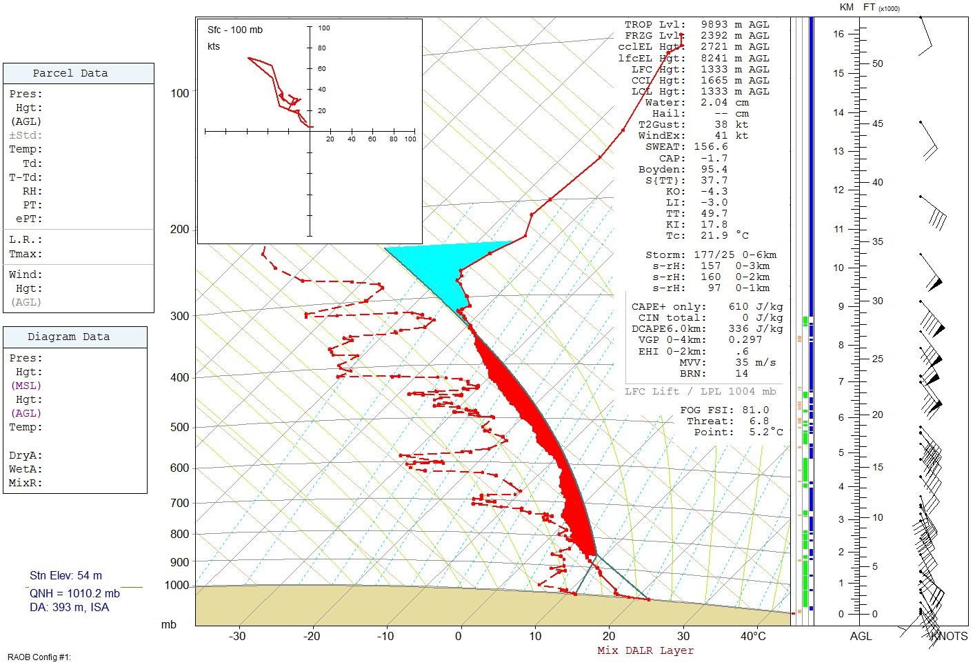
As expected, surface dewpoints have mixed out through the day across the Midlands, East Anglia and southern England, with values now between 9-11C (even as low as 6C at High Wycombe with some elevation). 12z soundings from both Nottingham (right) and Herstmonceux (left) (below, adjusted for typical surface temperature / dewpoint values over northern England and southern England respectively) both convect freely once temperatures reach or exceed 20C in southern areas, and 18C in northern England. However, the air is very dry through most of the profile and there are subtle hints of a slight warm nose at ~600mb (as expected), and it is quite likely, as we have seen so far, cumulus clouds continue to attempt to grow but mix out in the dry air aloft. Soundings also yield 800 J/kg CAPE at Nottingham with 23kts storm layer shear, and 600 J/kg CAPE with 33kts storm layer shear at Herstmonceux.
Essentially, the greatest instability currently lies over NW England and the far north of Wales where dewpoints remain 12-14C. However, the very dry profiles and the lack of any significant upper level support is significantly affecting the ability for deeper convection to develop. In the absence of largescale forcing, we are therefore heavily reliant on both low-level (sea breeze) convergence and/or upslope orographic forcing to providing a lifting mechanism.
Meanwhile, the upper low near the Brest peninsula continues to nudge northwards towards Cornwall, with lobes of PV rotating around it - this is aiding deeper convection in the vicinity of the Channel Islands right now. As this advances closer to southern England this afternoon, there will be a gradual increase in positive vorticity aloft (encouraging lift) which is likely to coincide with a moistening of the boundary layer as diurnal heating wanes and surface dewpoints begin to creep back up to 12-14C. Surface winds will also ease during the evening, allowing a corridor of low-level convergence and moisture pooling to evolve from SE England through London and the south Midlands. Consequently it seems plausible that deeper convection will develop into the evening hours, with scattered thunderstorms evolving - perhaps initially surface-based before eventually become elevated as nocturnal cooling of the boundary layer continues. This activity may persist until late evening in places before gradually weakening.
There may also be a couple of isolated thunderstorms that may eventually develop over NW England this evening,
-
12
-
11
-
9 minutes ago, Paul Sherman said:
Its too warm aloft and profiles up the column are too saturated for lightning hence the high rainfall totals and PWAT values
Probably going to be the same with the East Anglia Clipper tonight.
Tomorrow looks much better
12z Camborne ascent highlights the issues - limited instability (couple hundred J/kg CAPE), saturated through the convective layer and not particularly cold equilibrium level temperatures (-15C or so). Enough instability to generate convection, plenty of moisture available for heavy rain, but just not quite enough 'oomph' to generate lightning. Quite finely-balanced, especially considering the rain rates and lack of lightning...
-
7
-
-
5 minutes ago, John90 said:
Oh wow! My mistake then. The radar didnt scream supercell, but i guess they rarely do in this country.
I think there may be some confusion here - the cell in question I presume is this one that moved westwards to the south of Ringwood between 16:10-16:25?
Not entirely sure where this visible mesocyclone is over SW England right now though...
-
1 minute ago, convector said:
how did you get access to real weather balloon data? i can usually only find forecast skew-t's
Various places, but the University of Wyoming often has data you can either download in raw format to import into software such as RAOB, or you can use the pre-made SkewTs in GIF or PDF format:
-
1
-
1
-
-
- Popular Post
12z soundings from weather balloons launched at Nottingham and Herstmonceux highlight the subtle differences at play this afternoon between the heavy showers currently over the Chilterns / Oxfordshire vs Hampshire to Devon. I've modified both for typical surface temperatures and dewpoints present in the areas of interest, and both yield around 400-500 J/kg CAPE. However, Nottingham is much drier aloft and so this limits the depth of convection to around 18,000ft with cloud tops of -20C or so. Conversely, the profile ahead of the occlusion over central southern and SW England is moister with less mid-level inhibition, and so convection here can grow to 27,000ft or so with cloud tops potentially as low as -40C. Hence there has been sporadic lightning from the deeper convection over southern England, and so far none with the convection immediately behind the front currently over the Chilterns (started life over Beds/Herts at lunchtime).
Some modest 0-6km shear, around 25kts, over southern England too where convection is also being forced more strongly by confluence zone. Shower training/backbuilding over similar areas brings the risk of flash flooding given moist profiles and prolonged downpours.
-
13
-
1
-
Looks like two boundaries merged in the vicinity of the South Downs around the time the photo / videos were taken - this is a model simulation so may not be completely accurate in placement, timing etc, but it shows a plausible evolution this evening...
These showers developed along a sea breeze convergence zone. You can see in this model animation how the sea breeze developed late morning and advanced inland during the afternoon. Along this boundary, opposing winds (from the south and north) meet and the air then gets forced upwards, generating deep convection and showers or thunderstorms. This converging of winds also creates spin, or vorticity, and this can get stretched upwards towards the cloud base.
At the same time, a second boundary (warm front) was sinking southwards during the afternoon, and the two merged just north of Brighton around 6pm (17:00 UTC). This merging of boundaries can create additional forcing and spin, and this may have partly contributed to the funnel cloud that developed in the vicinity of the South Downs, before the whole line of heavy showers moved southwards / offshore...
-
9
-
-
Just to add 12z EURO4 to the mix...
Nice to see several models going for it at short range, unlike this morning's event where they had all gradually backed off the idea...
-
2
-


Storms and convective discussion - 18th June 2020 onwards
in Storms & Severe Weather
Posted · Edited by staplehurst
The UKV isn't exactly 100% right all the time, each run will vary (as is the case with all the other models too). What is worth noting though is that given the degree of CAPE over the English Channel overnight, any storm that does develop will be very active. Models will naturally struggle to simulate exactly where and when these will crop up, but the instability plume will be migrating gradually eastwards through the night so all areas have some level of 'risk' as a result. If I were in southern England tonight I would probably set a couple of alarms, window left open just in case - because it would be a shame to miss out on a potentially good show...