


MikeUpjohn
-
Posts
423 -
Joined
-
Last visited
Content Type
Forums
Blogs
Gallery
Events
Learn About Weather and Meteorology
Community guides
Posts posted by MikeUpjohn
-
-
In fact this is tomorrow nights Nadocast. Solid area of 5% tornado risk but all hazards are possible.
Definitely Will be watching until I fly out


-
 1
1
-
-
Liking the look of tomorrow and next Sunday. Spring is starting with a bang!
-
1
-
-
Out from 23rd May through 8th June. Hoping for a good year too! 3 days of road tripping from San Antonio to Denver to meet WeatherHolidays Tour 3 for the storm chasing. And I can't help but notice that road trip takes us across tornado alley to get to Denver too

-
4
-
-
Brilliant blue flashes of heat (lol) lightning to the West. Literally electric blue.
-
4
-
-
Lightning high in the clouds very distantly to the West of Macclesfield. Wind picking up but no thunder yet. Not got a good feeling about it, wondering about not chasing it. Looks like it really packs a punch.
-
5
-
-
33 minutes ago, toggerob said:
There's quite a pronounced squall-line developing in the Irish Sea which is inbound for the NW overnight with plenty of active strikes within the convection core, this would be the area expected to bring the strongest gales by morning and possibly some localised sferics before making it's way Eastwards.

Looking at going out but finding somewhere to position to watch it when Liverpool to Manchester along M62 is quite a hard pick!
-
6
-
-
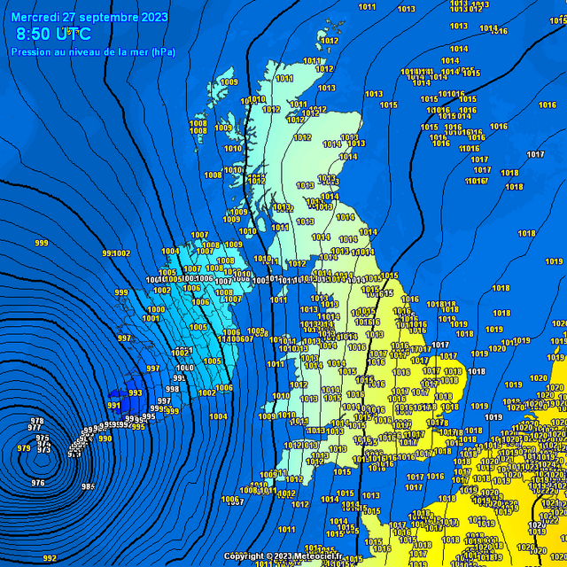
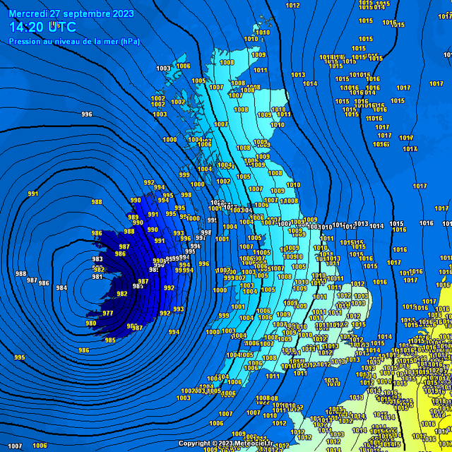
3 minutes ago, Kirkcaldy Weather said:
Looks like the pressure bottomed out at 973hpa in the area I mentioned.
From the current time is where concerns will increase as the SRH begins to intensify and the cells are beginning to take a supercellular appearance on radar
As mentioned it is the exact same principle
Breakdown: Why the right side of a hurricane is the strongest
WWW.ACTIONNEWS5.COM
All sides of a hurricane can be dangerous but the right side tends to be the most dangerous and the strongestLiterally came on this forum to have a look for comments because of the shape of those cells on radar. Scary looking!
-
Very dark heavy clouds over head in Macclesfield now. Not a breath of wind, misty, and eerie.
-
1
-
-
A line going up from Liverpool to Central Wales? Anything of note?
-
Just now, Turquoise said:
Very disappointing day up here yet AGAIN. Whenever we get these warnings of severe weather and thunderstorms the best we actually get is a few minutes of convective rain. Happens every bloody time.
Still stupidly humid and sticky here.
Not convinced it's all done to be honest.
-
1
-
-
2 minutes ago, Cloud 10 said:
Can hear thunder now from cell approaching the NE.
That might be interesting for everyone taking part in The Great North Run
-
1
-
-
Two new cells just forming between Crewe and Shrewsbury.
-
2
-
-
Got a few good rumbles and a couple of flashes of I-C lightning between Stoke-on-Trent and Tean earlier. Photo from a pub in Tean, Staffordshire and sunset from Cheadle, Staffordshire.
-
7
-
-
58 minutes ago, Ben Sainsbury said:
With a chance of this weekend being the last large thunderstorm days, decided I’m going to head on my first two day chase. Today going to target a few isolated thunderstorms over the East Mids, ready then to get into position for what could be a big day tomorrow.
Still a lot of uncertainty for tomorrow, so remains to be seen what my exact plans are going to be. Let me know if any of you are also going to be out chasing!
Likely that I will pop out into the Midlands or somewhere from Macclesfield when I see storms pop.
-
1
-
-
Torrential rain showers on and off very quickly for the last 2 hours and several rumbles of thunder. No lightning seen yet.
-
4
-
-
10 minutes ago, SNOW_JOKE said:
My eyes are on Stoke-on-Trent developments, as the sun is making an appearance here.
It seems to have gone up ahead of the line of others and its isolated at the moment
-
3
-
-
4 minutes ago, SNOW_JOKE said:
My eyes are on Stoke-on-Trent developments, as the sun is making an appearance here.
Agreed!
-
3
-
-
6 minutes ago, Supacell said:
Finished editing and uploading the footage from Sunday from the North York Moors and eventually ending up near Bridlington. Although storms weren't as spectacular as I had hoped it was a nice day out and there were some decent storms. Probably the most picturesque storm chase I have ever done, with scenery and views. I also don't think I ever remember as many members from Netweather chasing on the same storms either. It is good to see storm chasing in the UK getting more interest
Great video. Scarily similar to how mine started. Wetherby Services then Sutton Bank!
-
2
-
-
- Popular Post
- Popular Post
Sounds like we were all very close to one another. I left Macclesfield for Sutton Bank at 12.30pm convinced it was too late and we'd miss everything and be driving into the back of the cells moving away, but made good time over the M62 and were in position on Sutton Bank for 3pm, just as those storms started to go up.
Moved East to Pickering and then South, stepping down the cells, but ultimately got left with blue skies as it headed out to sea over Whitby and Scarborough way. Some definite brief supercell structures in there and a brief loosely organised wall cloud a couple of times, but couldn't get a picture as was driving. The final storm chucked out a couple of huge C-G gunshot thunders near Stamford Bridge.
Back home for 8.30pm and a great day of chasing in England.
Mike.
-
23
-
Good chase today around the Driffield and Pickering area of Yorkshire. Will post pics in the Yorkshire thread. Saw the squall on radar here. Looked quite mental.
-
5
-
-
Going to be heading out for a little chase later methinks. Those cells around our area look quite good, and am tempted to follow East over the Pennines if it's safe and there is no flooding, to see if anything happens.
Will post back if I get anything good.
-
8
-
-
Seen lightning from Macclesfield in the last half hour towards the SE. Orange, pink and purple.
-
5
-
-
Day 6 was a GEN TSTM Risk across most of the conus, with a MRGL in Deep South, TX, that wasn't really worth the long drive down for. Targeted some good diurnal storms around the Amarillo, TX area, which looked like good for photogenic storm clouds and lightning. After an 11am get-a-way from Andrews, TX, headed North past Lubbock, TX again and upto Plainview, TX and Braums for lunch and a milkshake. Storms were ongoing around the Amarillo, TX with a cold-core type setup. One storm was bold, and went tornado-warned for quite a while, and as we neared it, it sure did have the low-level wall cloud, but no tornado this time.
Stopped in a gas station South of Amarillo, TX with booming thunder, as a storm came over releasing torrential rain and a good lightning show. Edged South back towards Plainview, TX pulling off at Tulia, TX with some other storm chasers, before heading East and South stair stepping the storms that were expanding out at us.
Headed East and then North to Vega, TX but ultimately storms were dying off, so headed East into Amarillo, TX for the night, and dinner at a steak house. Later on a late evening lightning show off to the West after sunset.
Another good chase day, given marginal conditions!
-
1
-
-
Day 5 of the tour began in Odessa, TX after the bust from the previous day, and a MARGINAL Risk, less than 2% tornado risk, and 5% wind and hail risks, along the Eastern New Mexico and Western TX Panhandle border. After a late and relaxed start in Odessa, the plan was to drift North towards Seminole, TX for lunch and then into New Mexico to see what came of it. This area had been good for over-producing on low-end risk days this year. Lunch at Dickey's BBQ Pit in Seminole, TX before drifting onwards for a visit at the New Mexico sign and on towards Carlsbad, NM.
Several storms has fired in front and to our North, so we drifted towards Artesia, NM for a gas station loo break. Conveniently, a marginally-severe storm was beginning to roll into town, making the gas station canopy shake, and causing a LOT of blowing dust, and some good thunder and lightning. The storm looks promising, and was heading towards better air, so back East towards Lovington, NM.
Chased for another few as hours as the storms lined out with one brief very distant landspout to the South, before the storms started to decay. Headed into Andrews, TX for dinner and then to the hotel. While we were eating an outflow boundary of the line of storms we had been on, heading South and East, interacted with an outflow boundary of the storms heading North, near Odessa, TX and gave us a stunning backside view of the lightning in the updraft towers until gone midnight. Another brillian day, and all for a Marginal Risk event.
Artesia Storm is here on YouTube
Mike.
-
1
-


.jpg.dfa779224d9eed3e5d87b5c7b405248c.jpg)


2024 Tornado Season
in Storm Chase USA
Posted
Tomorrow looks better and better to me. Moisture returns and a dry-line sets up by the look of things.
HRRR 20z tomorrow
HRRR 23z tomorrow
HRRR 02z Wednesday
Some dew points into the 60s just. Looks like a late show for us watching in the UK though
And then this is stunning to look at for Sunday too. 18Z GFS. Watching the SPC in the morning for an update.