


Wet'n'Dry
-
Posts
826 -
Joined
-
Last visited
-
Days Won
1
Content Type
Forums
Blogs
Gallery
Events
Learn About Weather and Meteorology
Community guides
Posts posted by Wet'n'Dry
-
-
Just now, Thunderstruck said:
It’s not heading directly towards us but keep looking SW. It won’t pass that far away.
Yeah I've been watching that for the last 20 minutes, I'm wondering if we're going to get a fresh storm from our south east
-
Just now, Thunderstruck said:
It’s coming closer! Two bright flashes in quick succession, but still no thunder!
What direction is it coming from
-
Continuous lightning to my West, anyone in the Thurrock area is getting a great light show
-
Frequent IC lightning at least 10 miles to my SSE, at least 10 strikes per minute, no thunder heard yet
-
2 minutes ago, Thunderstruck said:
Couple of towers appearing to the south here, though whether we actually will end up with anything or not tonight is hard to say. Here’s hoping...
Nothing visible in Bas yet
-
- Popular Post
- Popular Post
3 minutes ago, Windblade said:What are we missing since the 80's and 90's?
Bananarama
-
 12
12
-
1 minute ago, Justin123 said:
I certainly will let you know about what you missed back at home tomorrow, lol. Yes I will, sorry haven't got too doing it been to excited the past few days. This better go bang big time.
Good luck for tomorrow Justin
-
1
-
-
3 minutes ago, Justin123 said:
Shhhhhh don't say that we need some storms here in Basildon! I think we may get the weaker storms and they strengthen as day time heating occurs tomorrow, with all that cape to tap into. But I hope I'm awoken by a storm in the early hours, I love that feeling.
I won't be in Basildon as I'm off driving around the south and east, be sure to give any reports if anything happens.
Also could you edit your profile to include your location, it helps a lot! Thanks
-
3
-
-
3 minutes ago, weirpig said:
Great my wife thinks I mad waiting up to see a storm. Now I'm waiting up for a forecast of a storm . Jezz weirdo alert
My wife thinks I'm weird but when it does happen she enjoys a good bang!!!
-
1
-
-
I think some people should accept they may not see a storm tomorrow. It's always been the case that a Thames Streamer or Kent clipper has happened that it was basically an import. Our weather is so dynamic that forecasting is not always an exact science, coupled with the fact that London acts as an UHI then anything is possible and may become a breeding ground for all points north
For tomorrow I wouldn't be placing the emphasis on the south east but more to the north and west of the severe risk area, it's just a gut feeling!!
-
1 minute ago, Jcweather said:
Essex Weather Centre (normally pretty reliable) just tweeted that the biggest risk in Essex tomorrow is from 05:00 - 13:00...
Anytime after 07:00 will do me fine, since I hate being woken up early!
Game on!! Tomorrow I'm driving from Basildon to Aylesford in Kent, then to Chessington, then Littlehampton then back to Basildon. If I don't see a flash during that time I'll be a tad disappointed!
-
3
-
-
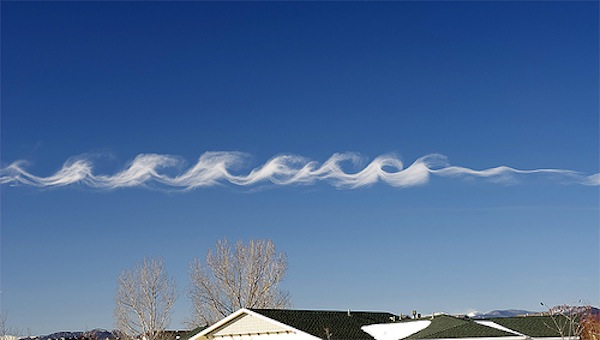
1 minute ago, Mokidugway said:
Kelvin Helmholtz clouds , nice
")
Shame I was on the M25 as I would have got a pic. Truly stunning!!
-
2
-
-
Evening all, I saw an identical example of these clouds over Surrey this afternoon. I thought it to be a good indicator of instability and here I am catching up on hundreds of posts!
http://earthsky.org/earth/kelvin-helmholzt-clouds
-
9
-
-
Huge drops of rain just fell, came from nowhere!!
-
Maybe they don't have the bandwidth to stream to all users, it only happens during peak periods such as we have today
-
Is anyone having problems with raintoday? I keep getting errors on phone and PC, something to do with Google maps not loading properly.
-
2
-
-
2 strikes within 500 metres of my house and another half dozen within a mile, I can still hear the storm rumbling as it moves off to my N/E
Edit: Should that be yards and miles or metres and kilometres
-
1
-
-
Wow!!!! Basildon just lit up, I've not heard thunder this loud in years!! CG's all over and very heavy vertical rain
-
2
-
-
8 minutes ago, Sentinel said:
Hi all, I'm a long-term lurker I've finally decided to sign up.
Can anyone on the south-coast see any cloud build up yet? I'm based in Southend and often sit on the seawall when storms come in as you can see them coming up over the North Downs, the Medway and over the Thames Estuary. Last year we had some fantastic cloud formation preceding one thuderstorms, so I'm hoping for something today.
Hi Sentinel and welcome to the group. I'm keeping an eye on this webcam as anything hitting Brighton is likely to have our name on it.
https://www.skylinewebcams.com/en/webcam/united-kingdom/england/brighton/brighton.html
-
1
-
-
8 minutes ago, Jcweather said:
Quite an inactive cell this one, only heard two rumbles so far. Both IC I'd say, as all the nearest ones on the detectors are out of earshot. Still, my first thunder of 2017!
Just 3 strikes, quite elevated and now fizzled out, at least it's a start!!
-
1
-
-
Thunderstorm in Basildon right now
-
Goodnight all, I have to get up early for work.
I hope you all get what you're looking for over the coming hours. Stay safe and get your pets in!
-
3
-
-
4 minutes ago, Frosty hollows said:
Well,maybe the motorway theory someone cited earlier has some credibility. An earlier M4 line,now one hugging the M25
M25's a car park, sorry no heat generated there!!
-
3
-
-
I've not seen a warning like this!!
http://www.metoffice.gov.uk/public/weather/warnings/#?tab=warnings®ionName=ee&fcTime=1473980400
An area of torrential, thundery rain is expected to develop across the region during early Friday morning bringing the potential for exceptionally large amounts of rain within a few hours. Frequent lightning and hail may be additional hazards. Whilst there remains some uncertainty about developments and areas affected, there could be major disruption. Please be prepared for the potential for very severe weather conditions bringing flash flooding and disruption to transport.
A cold front approaching moist, unstable air is expected to generate a line of exceptionally heavy, thundery rain. Possible sustained hourly rates of more than 30 mm could result in totals of more than 100 mm in 3-4 hours. Particularly in urban areas, this could lead to flooding of properties and businesses and major disruption to transport.
-
9
-


Convective/Storm Discussion Thread - 19th May 2018 onwards
in Storms & Severe Weather
Posted
So is a 15' carbon beach casting rod, that's why I stayed at home today