


Zakos
-
Posts
642 -
Joined
-
Last visited
Content Type
Forums
Blogs
Gallery
Events
Learn About Weather and Meteorology
Community guides
Posts posted by Zakos
-
-
I can understand the skepticism of some posters regarding the upcoming cold spell

But the day 6 output screams potential.
I was an avid watcher of the anomaly charts last season, and I dont recall seeing anything like this within the medium range.
All to play for IMO
-
 7
7
-
-
The medium range output is excellent and full of potential IMO, just in time for us to see widespread snowfall.
The jet stream looks like its going to become progressively weaker and less organised as we head into winter proper,
-
3
-
-
Comparing the current state of the PV to the forecast from the ECM and GFS at 168+, it looks as if its going to become rather disorganised.
Taking mid november, as the start of the countrywide "snowhunt" I think we may well be off to a very good start this season.
Im no expert, but the below chart looks very blocked, reminiscent of november 2010...
We had a lot of teases from the models last year, but i dont recall seeing such epic charts as these in the near-reliable timeframe
The consistency is notable, constantly we are seeing these very blocked patterns emerge in the output.Exciting times ahead I feel
-
9
-
-
Definitely the snowiest GFS run of the season Steve
.
Some runs are showing the cold shot to be quite potent... If we do see a direct hit from the N/NE in mid March, would it be plausible to see settling snow that lasts throughout the day ?
-
3
-
-
On the subject of the UKMO... how many times has the UKMO actually led us up the garden path? Not many that I can recall. Fantastic chart at 144 +
Odd that the ECM is not onboard as the ECM has given many a tease. Perhaps the ECM is playing it safe this time?
Encouraging that the UKMO is remaining consistent, with the GFS also on board the search for cold is very much still alive and just over the horizon.
-
4
-
-
7 minutes ago, Daniel* said:
It has to be an outlier surely the progression from 120 to 144 did not look right to me. The forum would descend into meltdown if that materialised even Tamara would be peed off.
Thats a quite a pattern change in just 4 days, incredibly progressive from the ECM
The forum would fall silent I imagine after yet another tease. The short term is so promising, surely we can snatch something wintry from this pattern? heres hoping!
-
1
-
-
ECM definitely on its own here at 144... only model to build heights over central europe and sink the scandi High.
Agreed a very painful run.Its possible, but my no mens a certainty. Still odds on for cold IMO.
-
1
-
-
- Popular Post
- Popular Post
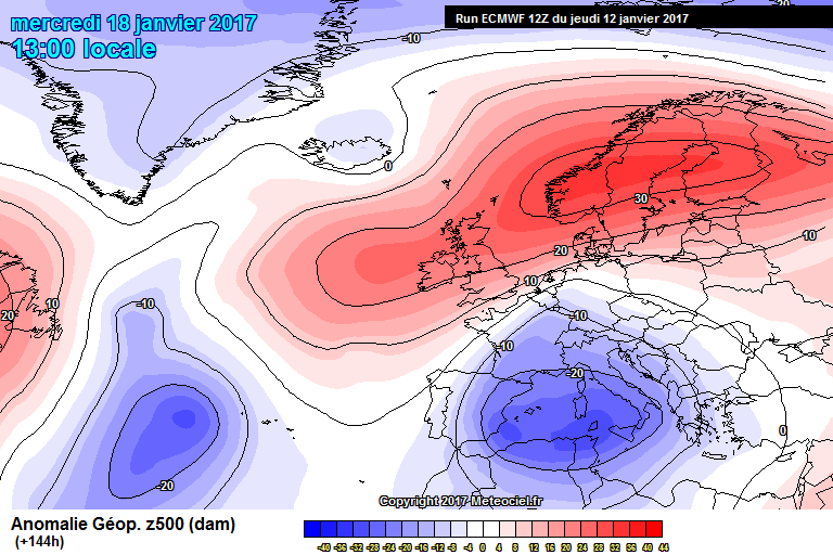
We have seen blocking events in winter as shown above, however the blocking has been mostly mid-latitude blocking, and and unfortunately not positioned well for the UK.
What we are seeing now is different. - True northern blocking
The block is appearing more resilient (overall) each day This is by far the most promising event of winter In terms of potential for a noteable spell of cold.
-
14
-
- Popular Post
- Popular Post
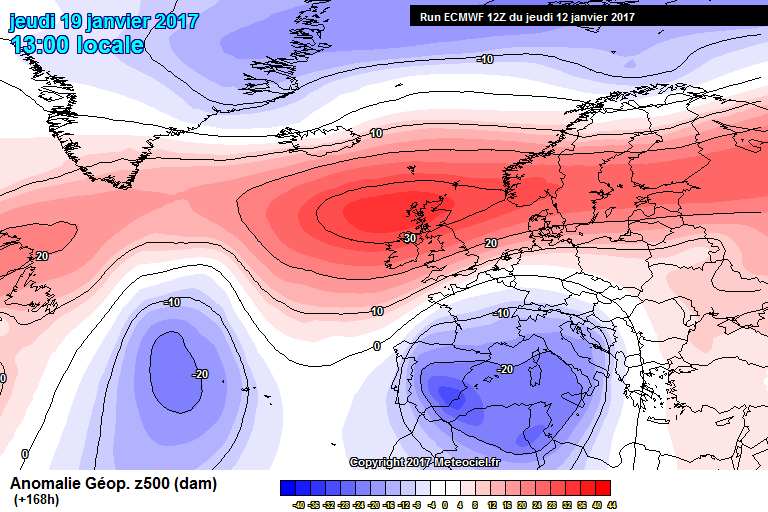
Atlantic is getting pushed further back each run, cold pool deeper and more directed towards us.
Scandi high remaining in charge out towards day 10 now
Long term thats a massive upgrade on the 06z.
-
10
-
Facsinating model watching. Lovely to see the forum buzzing again just as the chase for cold died off.
. The block has only just started to advance west across Scandinavia. Such a process is not going to be handled well by the models, and as such there are going to be wild swings in the output. By far the most promising event of winter. Based on how blocked the Atlantic has been for several months now, I think we are in for a prolonged cold spell here. Fingers crossed.
-
6
-
-
. That really is a humongous block , I find it unlikely that Atlantic will break through, especially considering how stubborn blocking has been this winter. The key difference this time is the high is suitably far enough north, and we have low heights to the SE. Exciting times ahead, expect wild model swings, as small differences in this setup can have massive implications for UK weather. I have already seen snow, but I am looking forward to a potentially memorable cold spell this February. I won't be getting excited till a snow event is shown within 96 hours. The word "potential" has been used a lot on this thread this winter. However it can't be denied,as things stand, this event has the most potential for a memorable cold spell to occur from any output this winter.Thrilling model watching.
-
8
-
-
Looking at the satellite images, looks like the west vs east battle has already begun. As some others have said , most promising charts of the season for deep cold.
-
9
-
-
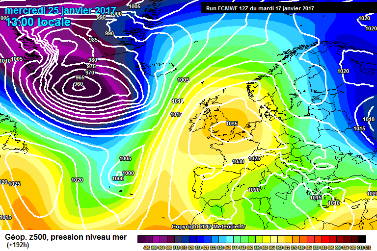
Well well well.... some very tasty anomalies from the ECM today
in the reliable...72 hours+ , that anomaly screams "battleground" to me.
Lets the ECM is on to something!
-
2
-
-
ECM mean anomaly for the 25th over the last 5 days. I do believe means can be useful to spot possible trends, but really are meaningless, in terms of forecasting UK weather, beyond 192.I think some people believe that the ensemble spread represents probability of cold/mild.
For example. If the GFS ensembles have 90% of the members showing south westerlies, this would mean roughly a 90% chance of mild weather.Beyond day 5 or so - this is simply not true. The ensembles will almost always follow the operational.
Others may feel we have been let down several times and that this is just another march up the garden path.
The reason models "default" to zonality, is because this is always the most likely scenario for the UK in winter.
That doesnt mean we cant see cold or snow. Were always odds against for significant cold here in the UK. But just because a horse is 8/1 to win the race, doesnt mean you wouldn't watch the race if you'd bet on it .
But isnt that what this thread is essentially about in the winter? the chase for cold. Its always odds against... but that doesnt mean it cant happen. That said I am considering spending next winter in northern siberia if I dont see a decent cold spell soon.
-
7
-
-
9 minutes ago, Steve Murr said:
Im surprised by the lack of posts ! the models are moving closer to something special , for here that may be a 2 week coldspell as this week the SE CET will be about 0c
The 18z are known for their resolution however lets see what they can drag out the fire...
Me too!
We are pretty close to a snowfest on the 18Z GFS
Very far out obviously, but both ECM and GFS have been toying with heights to the NE for a while now
both ECM and GFS anomaly at 144 screams "battleground " to me
We can only hope the block is as stubborn to remain here as it was over the UK.
-
1
-
-
- Popular Post
48 hours ago, the ECM operational and mean anomaly "guaranteed" a return to zonality
Now the forecast for the 25th shows a large anomaly to our NE, seemingly it has appeared out of nowhere.
If the ECM underestimated the block so much, there is surely scope for the forecast to further improve?
Not saying we will see a raging easterly, but I find it hard to believe we will see the atlantic come barreling through the block, without at least a snowy breakdown
The above chart is only 168 hours out, I would have thought there is good potential for a Scandi high to form... with a bit of luck.
-
23
-
5 minutes ago, karlos1983 said:
If it carries on that path we will have scandicelic high
nice trend.
indeed, very nice trend!
A complete reversal from the GFS if you compare today's chart to the forecast yesterday morning, very poor from the GFS.
ECM ( if this verifies) was far closer to the money.
GFS defaults to climatology far too often IMO.
-
2
-
-
- Popular Post
The last six runs for the 24th from the GFS.
If thats not a trend away from zonality, and towards the cold air remaining entrenched over Europe, then I dont know what is.
No prizes for guessing which direction the 18z is heading lol.
-
12
-
Its not a day 10 fantasy tease though.
At 192 The ECM is far better than GFS,and clearly indicates heights rises to the North East.
The GFS is terrible at modelling the removal of entrenched cold air
A look at the last 4 runs for the 25th clearly shows this, it did exactly the same during the last cold spell.
yesterdays 18z had the warm front edging into poland, now the GFS has freezing air over all of England and Wales.....
ECM is on the money, cold air will not be removed swiftly, and there are tentative sings of height rises to the NE... this is still too far out to get excited about granted.
-
6
-
-
Both ECM and GFS have shown a drastic shift in the medium range output.
As others have alluded to, the models are not dealing well at all with the supposed removal of the cold air entrenched over Europe.
Yes its day 10, but that anomaly screams cold weather potential
Even at 192, the anomaly is fantastic. The cold air, it seems, is going nowhere without at least putting up a fight.
-
4
-
-
GFS 06Z mean seems to indicate a battleground scenario is possible, looks like some members want to build heights to the NE.
-
3
-
-
Comparing this pattern to the previous cold shot into Europe in early Jan, certainly looks like the cold is edging closer.
-
1
-
-
24 minutes ago, Geordiesnow said:
I think a snowy easterly was never really on the cards Zakos, as thicknesses are not all that low and even the ECM never forecast pressure to get all that low either. What could change is the UK taps into the colder air but it does now look like the ridge is not going to be as amplified as first thought so it will be tough to get especially cold air in terms of uppers at least. Do hope at the very least we get a SE'ly flow to help melt the cloud away as this high looks like it will start off as a cloudy one with a weather front trapped within it.
A true convective easterly within a week is unlikely I agree
But we could surely see moderate snowfalls across england based on the 12z GFS
Depends what you're looking for I guess, watching snow fall is more than enough for me personally
-
2
-
-
- Popular Post
I think the potential in the medium range is being overlooked
With anomalies like these from the ECM at 144+ and 168+.... surely there is potential for a small shift in the output to produce snowy scenarios ?
At the very least for eastern england and across the south and southeast?
Many people have stated to wait until 72+ to be confident in regards to an easterly.
Surely, by that logic, a snowy easterly feed could crop up after the 72 hour timeframe?
-
10


 .
.


 . That really is a humongous block , I find it unlikely that Atlantic will break through, especially considering how stubborn blocking has been this winter. The key difference this time is the high is suitably far enough north, and we have low heights to the SE. Exciting times ahead, expect wild model swings, as small differences in this setup can have massive implications for UK weather. I have already seen snow, but I am looking forward to a potentially memorable cold spell this February. I won't be getting excited till a snow event is shown within 96 hours. The word "potential" has been used a lot on this thread this winter. However it can't be denied,as things stand, this event has the most potential for a memorable cold spell to occur from any output this winter.Thrilling model watching.


Model Output Discussion 01/09/17
in Forecast Model Discussion
Posted
the jet stream is weaker on each successive GFS run, with a tendency to send more energy south.
Quite a notable upgrade, not looking good for the PV if the 12z is to be believed.
I believe the key may be the much stronger warm air advection into the canadian arctic on the 12z