


Polar Maritime
-
Posts
14,442 -
Joined
-
Last visited
-
Days Won
10
Content Type
Forums
Blogs
Gallery
Events
Learn About Weather and Meteorology
Community guides
Posts posted by Polar Maritime
-
-
-
A few light showers yesterday evening died out to leave a cloudy night with light winds, An overnight low of 6.4c.
Currently; Damp with thin cloud clearing.
Temp 7.9c
Dp 7.3c
Wind S/W 4mph
Rain since midnight 0.0mm
-
Sorry for the error this morning, and thanks TM for correcting me. Moving on, A dry day with clear blue sky's this morning, but patchy cloud developed this afternoon and the wind picked up a little. A max temp of 10.2c.
Currently; Patchy cloud and breezy.
Temp 10c
Dp 8.3c
Wind S/E 14mph
Gusting 33mph at 4:19pm
Rain since midnight 0.0mm
-
 1
1
-
-
Air Frost here and slight ground frost...
Edit- no air frost only ground.
-
1
-
-
http://www.youtube.com/watch?v=hdV51YaGlnA
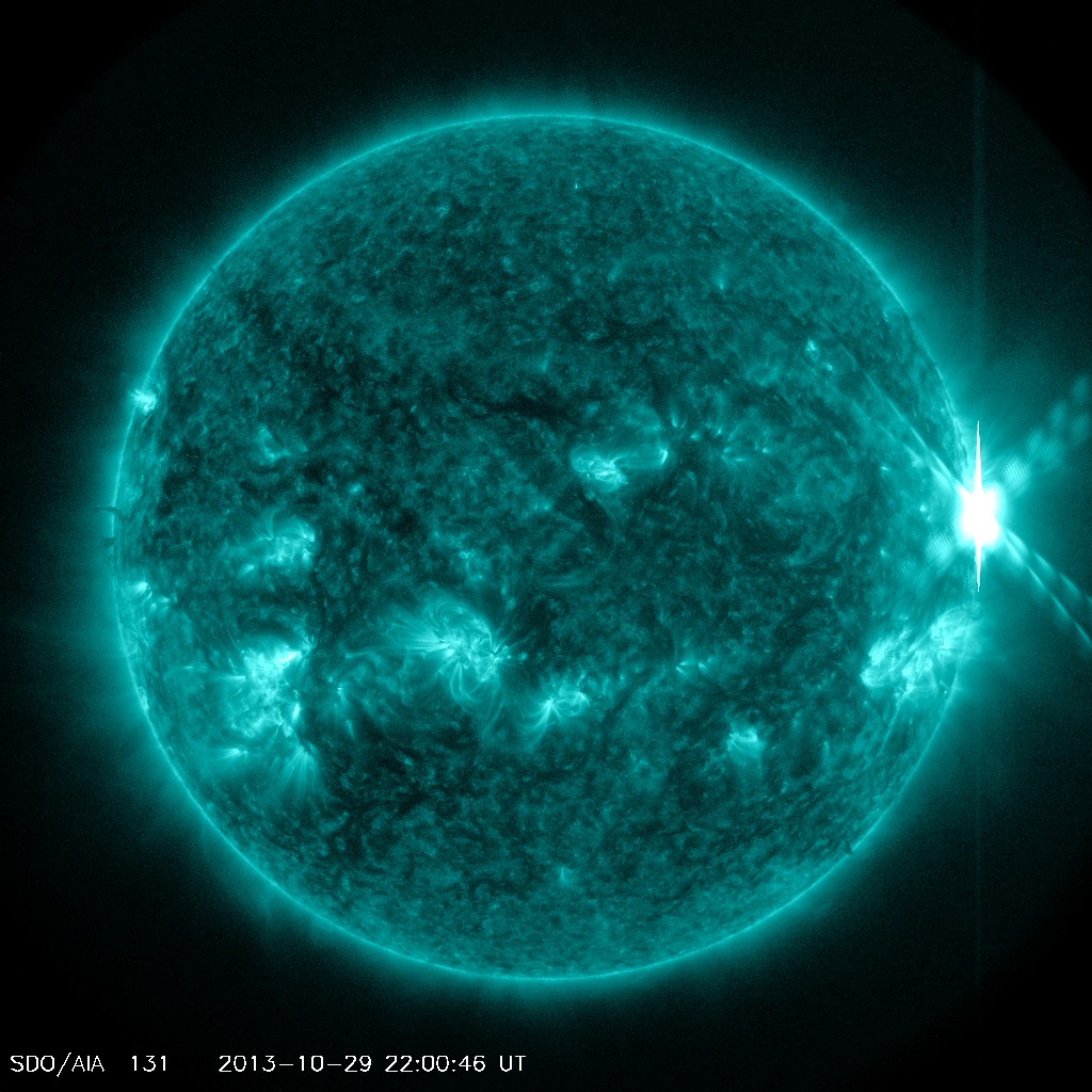
ANOTHER X-FLARE: Consider it a parting shot. Just before sunspot AR1875 rotated over the sun's western limb on Oct. 29th, it unleashed a powerful X2-class solar flare. NASA Solar Dynamics Observatory recorded the explosion's extreme ultraviolet flash: http://www.spaceweather.com/

-
Slight ground frost here, had to scrape the windscreen this morning, Heavy showers continued yesterday evening but slowly died out leaving 16.2mm of rain yesterday, before sky's cleared. An overnight low of 2.6c.
Currently; A lovely Autumnal morning, with a crystal clear sky's.
Temp 2.6c
Dp 2.1c
Wind South 0mph
Rain since midnight 0mm
EDITED after reading TM's post. Not cold enough last night for an air frost.
-
I certainly wouldn't grumble.
-
1
-
-
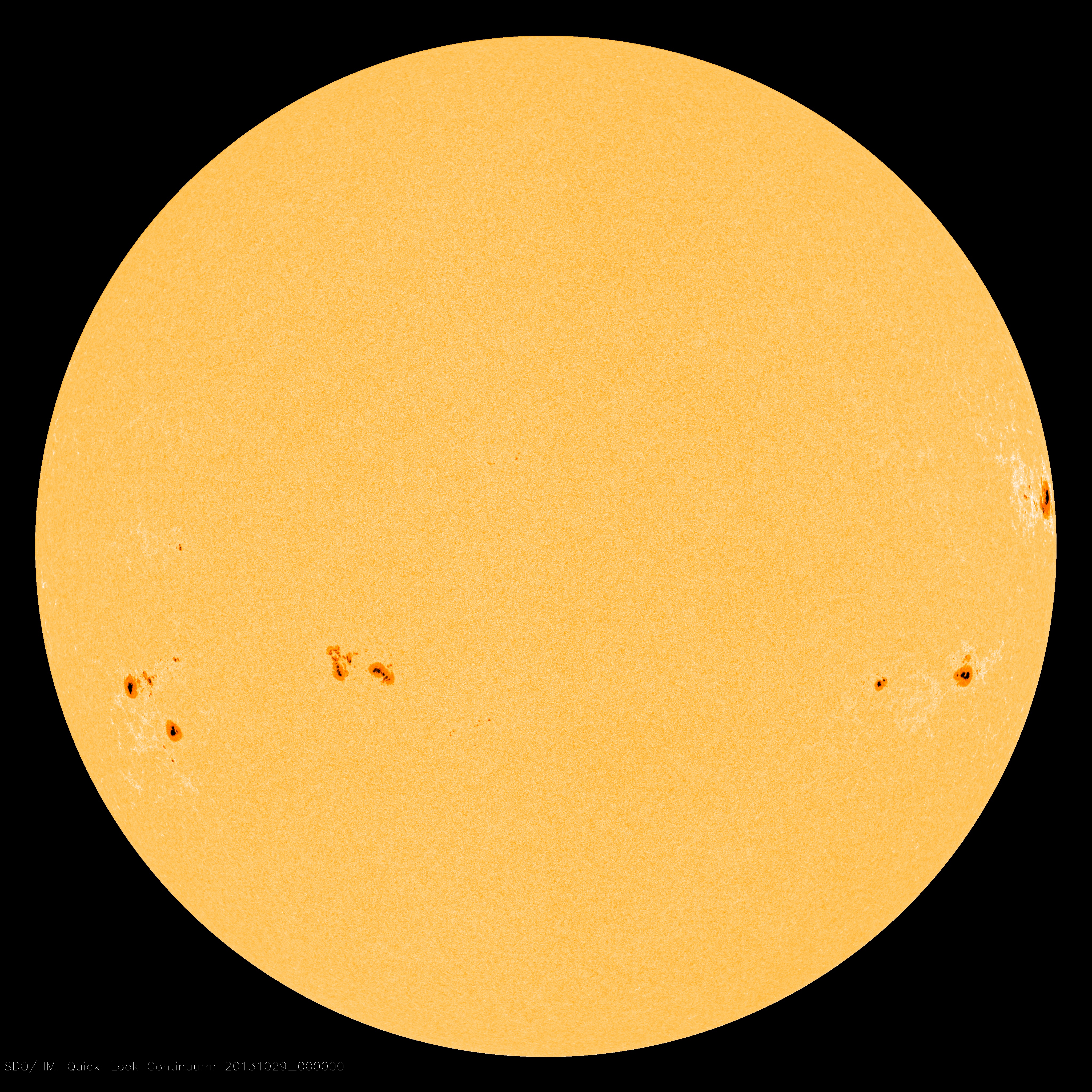
SUNSPOTS MOST LIKELY TO FLARE: The sun is dotted with spots, and three of them pose a threat for strong eruptions. Today's sunspots most-likely-to-flare are circled in this Oct. 29th image of the sun from NASA's Solar Dynamics Observatory:
AR1875, AR1882 and AR1875 have 'beta-gamma-delta' magnetic fields that harbor energy for X-class solar flares. One of these spots in particular, AR1882, is almost directly facing Earth, so any eruptions it unleashes would almost surely be geoeffective. NOAA forecasters estimate a 70% chance of M-class flares and a 35% chance of X-flares on Oct. 29th. http://www.spaceweather.com/
-
High Solar Activity continues, the Sunspot count is now at 206. There are many active regions which are Earth facing, with new regions also forming.
http://www.youtube.com/watch?v=ufEEMD1TaFw
And from this morning....
-
A cloudy night, with Moderate rain starting around 4am with light winds, An overnight of 7.7c.
Currently; Moderate rain, light winds.
Temp 7.9c
Wind W/N/W 8mph
Pressure 979mB falling
Rain since midnight 3.9mm
-
-
Yes Mod rain here to for the last hour or so, 3.8mm so far, Pressure 979 mB and falling, N/W 7mph...
-
-
My post from yesterday at 11:42am. Ahead of the charts, ahead of the Met office. They should really use historical data when working out the weather charts....if I can call it without weather tools, I'm sure they can with.
-
2
-
-
A simple question,is this going to be a damp squib then?
No, not where the warnings are in place. Best listen to the experts as far more knowledge and data..
-
A cloudy night with a few clear patches and light showers during the early's, An overnight low of 7.6c.
Currently; A few light showers, mostly cloudy with the sun beaming through at times and blustery.
Temp 9.5c
Wind S/S/W18mph
Gusting 34mph at 5:07am
Rain since midnight 1.1mm
-
Matt on BBCnews just said he's just had meeting with Chief Forecaster and no change from 24hrs ago with track of storm.
-
5
-
-
To think....we was all getting excited about something that existed in a computer.
And they say machines haven't taken over the world ??
What a complete let down, looks like I'll be going into work on Monday after all, head hanging in shame feeling like a complete idiot.
I blame the government who have probably been flying planes doing some sort of cloud seeding or something to make sure this didn't evolve into a monster, as it would have cost them too much in lost profit had it hit
the moral is never to get excited about something that doesn't exist !!!
It's not happened yet !
All still on as forecast this morning. Just maybe not the extreme version, who knows, plenty of time yet for more flipflop's in the charts
Read all the warnings and forecasts and take note of RJS, not one model run for now.
-
1
-
-
Its what he is paid for?
Yes John, and those responsibility's come with a good pay packet to !
-
Im pretty sure it would dropped to -30c at some point in the past in the highlands, I've withstood -38c wind chill on Ben Nevis, that was pretty cool...
-
1
-
-
Based on the current runs I would think Derbyshire will experience the strongest winds from the W/NW as the low pressure moves away to the east. There's still the potential for gusts of 60-70 mph, even at lower levels, as there's a tight squeeze of the isobars on the western flank of the depression.
This is certainly not a done deal however as the low is barely a gleam in its' mothers/fathers eye at the moment and slight changes of track, speed and intensity could have significant implications for areas which are currently on the margins of the most severe weather.
Thanks for that TM ! Hopefully this storm will produce something eventful for these parts...
-
A cloudy breezy night with the odd light shower, an overnight low of 11c.
Currently; Overcast, with light rain.
Temp 11.7c
Wind S/S/W 12mph
Gusting 28mph at 12:14am
Rain since midnight 1.8mm
-
But we love cold
Is that not cold enough for you..!
-
2
-
-
The models still don't know where this low will place its self
Nobody will no the exact track until Sun, plenty of chopping and changing over the next 48hrs.
-
1
-


Friday 1st November General Weather Chat
in Spring Weather Discussion
Posted
A dry night with clear intervals and an overnight low of 5.4c.
Currently; Dry and mostly clear with light winds.
Temp 5.7c
Wind S/W 6mph
Rain since midnight 0.0mm