


Whether Idle
-
Posts
213 -
Joined
-
Last visited
Content Type
Forums
Blogs
Gallery
Events
Learn About Weather and Meteorology
Community guides
Posts posted by Whether Idle
-
-
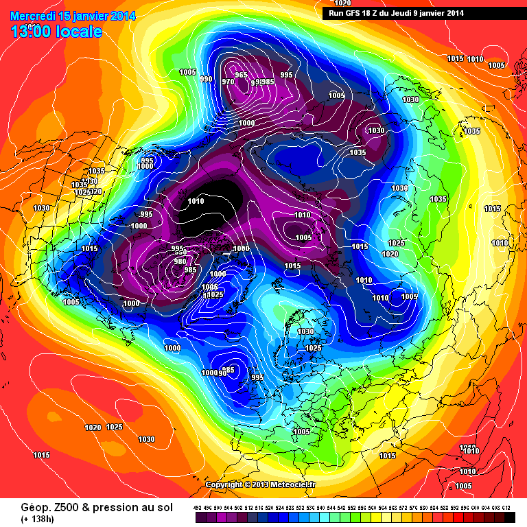
http://www.meteociel.fr/modeles/gfse_cartes.php?ech=180&code=0&mode=0
At 180 and looking like a cold shot for the NE?
-
http://modeles.meteociel.fr/modeles/gfs/runs/2014010918/gfsnh-0-138.png?18
I know its commentary but who cares-
Isolines bending back SE- with trough elongation- 144 & 150 may spin the frontal band back west with snow on the back edge.
Also see the scandi shortwave lifting out the way-
S
Its way better than the 12z. Nice little trough opening over Europe at 144.
-
HP block seems further north than on 12Z, not good sign surely? this low could stay around the UK
The low needs to slide SE rather than blunder around Shannon
-
Looks like a better run at 96, dare I say it trending slightly more GEMish?
-
 3
3
-
-
I remember several days ago Ian F saying only about 20% MOGREPS and other in house models 'going for ' an easterly flow....
MOGREPS seems fairly well programmed. Shame we don't get to see it.
-
2
-
-
The ENS stamps @ 120hrs are a mess. Could go either way yet.

Cluster 2 (13/50) is favourable for a decent cold blast at day 6 or 7. That's about a 1 in 4 or 5 chance so 20%. 80% chance of something less pleasing.
-
1
-
-
Heavy rain getting heavier here.
-
Could get interesting towards the Kent and Sussex coasts for intense rainfall after 10pm
-
2
-
-
Upgrades are required as we move into the reliable for a northerly of disruptive power
-
, there is a 168hrs but for some reason the UKMO view this as top secret, apparently its under armed guard 24hrs a day in case God forbid a member of the public could actually view it!!!
I see why - it keeps the product as one of relative quality and accuracy, avoiding much of the FI pfaffing. That's not to say the Met O is always accurate - I think it verifies at 144 usually in second place; though by virtue of its short time period it avoids the same number of reversals the longer reaching models inevitably suffer from.
-
Some are saying the gfs is wrong and go with the ECM. But wasn't it the gfs that got the pattern spot on other week and trounced the ECM
Correct. But that is no guide to this episode.
-
2
-
-
Wish it was cold enough for snow we are getting some very heavy showers, possibly a slightly split streamer, but it's all rain.
Hi Alexis. I was out in the car and it was wintry with hail and lots of sleety blobs on the windscreen as the ice melted, so not just rain but not a lot more either!!
-
Still differences in the models at T192.
GFS:
gfs-0-192.png ECM: ECM1-192.gifI am gonna hazard a guess that both are wrong and that the only certainty is a blocked Atlantic, cold air close to the UK and little precipitation.
It would be noteworthy if there weren't differences.
-
Great post from Steve. It is always a breath of fresh air when people don't treat the models as gospel, and it is surely entirely sensible that people (rather than algorithms) evaluate the strengths and weaknesses of the models?
-
5
-
-
Their are still the odd snow patches visible on the Downs from last weeks snowfall!.Hopefully more to come
Indeed the most reliable piece of weather lore is "when snow lays around in ditches and by hedgesit is waiting for more
-
Saturday's looking potentially snowy on the hills of eastSussex. Maybe a last snowy hurrah for the longest snow season in recent memory ?
-
I am getting happier by the minute!
Tamara. This could be THE BIG ONE!!
WI
-
Very cold windchill and drifting snow here at Dover cliffs. Feel sorry for the sheep aroundabout like me looking for a bit of shelter. Had enough and heading for my car. Sheep not welcome. My sympathies dont extend that far!
-
Decided to get a taste of severe winter weather. Headed to St Margarets Bay. Currently at national trust area by Langdon Bay met station 117m SSL. Continuous light to moderate snow blowing near horizontally in winds of 25kmph. Drifting snow all surfaces with a cover of
About 2 cms temp around -0.5c
-
We have 1 mighty cm here at sea level IMBY. I imagine St Margarets Bay (100m asl and furthest SE) will be the sweet spot. Upper air 850s are staying low so it could be a snowy day in east Kent with altitude and proximity to the south foreland being key variables affecting snow depth - maybe Langdon Bay/ St Margarets will get another 3 cms today?? Snowing moderately but fine individual crystals. Air +0.9 dp-2.0. Good luck to all
-
Good chance of some accumulations on a line from Whitstable-Ashford Rye eastwards overnight. Up to 3 cms perhaps, nowt to get too excited about but just about worth the effort. Streamer type showers forecast to kick in from around 10pm this evening til 10am tomorrow - then it warms up a degree or two.Maybe sweetspot will be Whitfield/ Langdon Bay hill tops? Good luck and if the showers line up into bands you never know...
-
Heavier bursts of snow and soft hail here, giving a meagre dusting...
-
Damn this dry cold! I'd planned a night in with a bottle of wine and a lamppost, now what am I going to do?
Drink the wine and wait.
-
i think the whole region bar the very west edges such as Bracknell out that way could do okay tonight 1-2CM then where the showers do get in .. 3-4CM nothing major just a covering... If the Thames kicks up a gear... Well..
Some places in the bands of showers may get much more than 4cms. Maidstone - TWells?? and maybe Leatherhead area if the band aligns further west. Good luck!


Model Output Discussion - 10th Jan Onwards
in Forecast Model Discussion
Posted
Personally though the Atlantic looks to win this week I would not be surprised to see the models looking cold and easterly led come Friday. Time will tell.