


Dave Kightley
-
Posts
523 -
Joined
-
Last visited
Content Type
Forums
Blogs
Gallery
Events
Learn About Weather and Meteorology
Community guides
Posts posted by Dave Kightley
-
-
A link on a youtube of the snow from the 4th November if anyone hasn't seen it.. I will also post part 2... Pre-Winter warm up
-
The world most "clear outlier". lol
OH Damn! lol After all that fuss earlier if the 06z is rubbish
-
LOL,the rest of the ensembles must be missing some data....

Even though its an outlier, has it picked up a signal?
-
Who's feeling a chill in the air after a great GFS 12z run? Fingers crossed for a better winter this year
-
Although things sound hopeful. I'm sure the charts are programmed this time of year to make an excuse for national newspapers to make stupid headlines
James madden website is very quiet at the moment... I wonder if he's praying that the sun doesnt come out this winter with his Very heavy snow larky
-
this is for the October November and December..not all of winter
Sounds good for the start of it anyway
we need a cooler this time of year -
putting this aside fl seems to be around 130z as steve said. alot of changes i gather until the models agree on the pattern ahead. it must be hard to deal with a whole NH pattern changing for the models
-
nice end to the run though steve. shame high pressure builds back in right at the end?well no stella run but better-
The GFS is handling the system over the central states at 130 totally different to the ECM- the ECM holds it as one & moves it up to the canadian maritimes, where as the GFS splits it & ejects a shortwave east off the coast - ensuring that no ridging can get going North-
Pity because the AO index & 180 will be the lowest reading of the winter-
S
-
ouch 18z 216 that another high to our south..........
-
that trough has gone on the gfs 18z that nick was talking about earlier on. like on the ukmo... which has made the difference j.s
-
GFS ens still showing a cooling down period around the 13th-15th... as some people have said of the possiblitty of cold zonality. 12z showing a weaking p.v and height rise over the artic. things will take time to happen but the signs are there. cold zonality can't be a bad thing if it leads to something better down the line?
-
gfs 18z oh dear! hopefully its had a few to many tonight. ecm 12z 240 comes to some interest on the big day
-
not the best of runs again today... at least it theres not much rain about at the moment...
-
not an outlier completely although only a few others.....the control run for aberdeen is nice....... overall average tempertures for now.
-
could be a no frost club 2
well any wintry weather. do u know of any snow over the ski resorts in scotland as of yet? -
cant believe how mild this month has been. as it has been said... it has been one crazy year
-
early december maybe if gfs 00z. been a long time since ive seen snow here. boxing day if i remember
-
was the 14th November yesterday when I made that post, 15th today. Am a bit confused really, seeing as December doesnt come in to the high res or even the low res outputs of either the GFS/UKMO or ECM yet, that there are fellas who are being told in no uncertain terms that a change isnt possible
The CFS charts do suggest a continuation, but they are at that range hit and miss. They could be right but my feeling is that if they were always correct, the Met office would not have abandoned seasonal forecasting. Were right about december last year, but I seem to remember they showed a strong signal for a cold November for a long time and that hasnt materialised at all for a start
Have been some hints of a change in the ensemble and later chart outputs, which have been perhaps a bit more louder in the last day or so than they have been, though I personally dont expect anything notably cold before the month is out. But to write off december I think is ludicrous at this point. The difficulty with places like these is that many people take things only on face value and perhaps overlook that small changes in the short-medium term can cause big changes upstream. The normal reliability rule with models is about T120 as a cut off point normally, with a absolute max of T240 for a default sou' westerly or for a notably stubborn pattern. About 10 days at the very most, which doesnt cover the whole of the rest of this month. After then it's trends only, and for me they have been a bit more mixed lately than they have been
look at the gfs run 00z... sums up what your saying pretty much
-
a nice end to the gfs 00z once again this morning. most of europe cold by the end of it..... pressure high out west.... not much support else where as i gather so il take it as a pinch of salt atm.. see what ecm does
-
http://www.cpc.ncep....y/814day.03.gif
I wonder if people can spot the theme here... trough to our west, ridge to our east (this time extending as far west as the UK), anomalously low heights to our north.
With the Pacific wavelength more or less set, little is going to shift this until we get into deep winter and the wavelengths bring about the change.
When do you think this will happen? in january?
-
Blocking at the end of the run? so diffrent then the ecm though. all to play forYou could say the same of the GFS and also a few other models, they haven't given up with showing the Atlantic coming into play for a period of time, ECM seems on it's own here with the blocking positioning.
-
no snow overnight but there were in my dreams and alot
-
i smell frost coming shortly
when does it get busy in here..... if the models are anything to go by soon i surpose -
signs are there. frost will do for now...!


 we need a cooler this time of year
 well any wintry weather. do u know of any snow over the ski resorts in scotland as of yet?
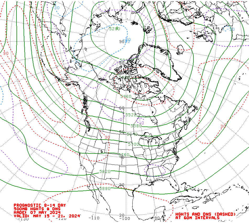
Southwest & Central Southern England Regional Discussion
in Regional
Posted
It was taken between Wincanton and Sparkford on the A303