


swebby
-
Posts
3,248 -
Joined
-
Last visited
Content Type
Forums
Blogs
Gallery
Events
Learn About Weather and Meteorology
Community guides
Posts posted by swebby
-
-
Nick F Many thanks Nick, an excellent blog piece.
-
 1
1
-
-
Just some considerations -
First, obviously we are currently in an el Nino phase that started back in June last year - the point that orange line really begins to diverge from the norm.
Second, The article talks about abnormally high North atlantic sea surface temperatures. I note that it was a relatively quiet hurricane season in the Atlantic basin with many of the emerging storms in the East Atlantic getting battered by wind shear and not amounting to much. So the overturn of the sea surface and the huge amounts of energy from the sea that these large hurricanes normally suck up never really occurred.
No idea if these are the reasons, even if they are, that graph is rather alarming.
-
2
-
-
QuoteQuote
On 23/01/2024 at 22:47, Met4Cast said:
Replies to hours old posts will have less context to them and without the context of the quote, posts will make absolutely no sense.
@Paul what I've seen on other communities with a similar set up to what you're trialling now is that the "reply @mention" when hovered by the mouse or tapped on a mobile device brings up an overlay that shows the content from the replied-to post. Similar to what happens here where if you hover the mouse over an @mention it brings up the user's profile card, hovering over the reply arrow icon could bring up the content of the post.
This would be the way forward i think.
Just had a quick drop in on the MAD thread and it is now full of responses that make little or no sense without seeing the original comment. If the OP is on a previous page or someone is posting multiple times you have to navigate to and fro just to see those comments making the thread far from user friendly. Also looks like posters are now confusing responses from different posts, especially if the exchange involves a third person and this is when that thread is quite, suspect it will fall apart if the models start spitting out cold solutions come next week?
-
1
-
-
2 minutes ago, jtay said:
2 hours of radar grabs and it's hardly made any progress towards us. Like a brick wall.

That's not a brick wall - it's the Dorset snow shield turned up to 11 and keeping it away from the whole of the SW!
-
9
-
-
48 minutes ago, TwisterGirl81 said:
We got that in 1990 burns day storm in the south west, we also had some strong storms during winter I think in 2013 that were severe but not as severe as 1990.
I have noticed that gfs does tend to over blow these lows several days out but occasionally they get it right. Some exciting weather none the less hopefully. A cosy day indoors I think
Normally that was because it had the habit at 6-7 days out of dumping all the energy into a dartboard low without resolving that low into multiple centres and shortwaves.
This instance however... it already has a complex system for the longwave trough and has now put a frontal wave under the left exit of a jet streak in the mid atlantic on saturday evening - so very definitely one to keep an eye on! Those GFS gust charts are hopefully over egging the pudding for Wales and Western England but probably an idea to make sure the trampoline in the back garden is bolted down anyway!

-
5
-
 1
1
-
-
7 minutes ago, Frank Trough said:
yes, rain is always my assumption for the Costa del Bomo in these sort of situations (to be fair, if snow was everything then i wouldn't live here so i can't complain too much :)) . 2018 was perfect for here because it came from a cold easterly and we retained the cold continental air as the front slid along. That said, inland from here still did better in terms of accumulations.
I'd like to see the front stay well away to be honest - send it through France. Keep the cold dry theme as long as we possibly can and see what plays out.
I've monday and tuesday 22nd and 23rd booked off hoping to do a bit of fishing on the stour or avon. If we can stay dry i think they'll be in decent condition - any rain (unless very light and brief) is going to mean that Mrs Trough will have a "list of jobs" for me instead. So i am a bit biased here.....
That 2018 was the result of an Easterly setup which with high pressure normally near scandi is an important consideration, Easterlys tend to put up a lot of resistance to warm incursions and therefore a correction south of any 'runner' low from the Atlantic is not unusual.
This event however is a straight northerly, so I have much less confidence that things will move south in a way that gives a snow fest SW of Swindon. It'll be the usual - either north of the M4 and cold rain for us, or snowmagedon in France and we may see the odd snow grain. As you say, our locations offer lots of other benefits so should not worry too much if we miss out.
-
2
-
-
1 hour ago, Glenosnow said:
Good morning,...-1°C here and clear skies.
Just before I go into work I'd like to ask the more knowledgeable peeps in here a question.
Why are the temps not plummeting at night in clear skies and cold in situ?.....I'm not getting it....I thought they'd be dropping further
 .
.
I'm not even bothering with the MAD thread....if we get snow great....if not..keep up the nice cold bright days
 .
.
No expert but I believe it is because that the upper (+500m) air temps since Tuesday are no longer that cold (only just below freezing) so the surface temps are kept from plummeting.
-
2
-
 2
2
-
1
-
-
49 minutes ago, Frank Trough said:
These “southward corrections” that “always happen” need to start showing fairly soon. I.e. everything needs to look like a slightly more south ECM from here on.
2018, the correction south started to appear about 3 days before the snow hit and was only accurately modeled about 24 hrs before hand. I remember the toys leaving the pram big time in the MAD thread as many north of Gloucester had taken it for granted a week before hand that they were going to be snowed in.
While a correction South is certainly plausible, a much more progressive incursion of the warm air can not be discounted. I always take the view that us living on the south coast west of Sussex should just assume rain and take any snow as an unexpected bonus.
-
4
-
-
2 hours ago, snowdog said:
I see the Bournemouth Echo have the headlines saying 'Heavy Snow forecast for BCP'. Not sure where they get their info from?
All I see is the possibility of a few flakes falling. Oh well, happy for them to be correct if it happens.
I had the impression that a few flakes counts as heavy snow for Bournemouth and Poole!?
There are not many places in mainland UK that do even worse for falling snow than here in Exeter but of what ones there are, i'd have Bournemouth top of the table.
-
7
-
1
-
-
10 minutes ago, Rob 79812010 said:
Question for long time model watchers. When the charts consistently showing colder temps out in F1 which then come into the medium term, is it still feasible it can all go belly up??
Yes - at least in the past that has been the case. These models have however been regularly upgraded over the years and so the "reliable" time frame has extended out from 4/5 days towards 9/10 days.
If you compared runs, things that once need to be considered for Easterlies was is if trends began to show for adjustments of the pattern east. What would be looking great 6 days out could end up being a damp squib with a cold pool being deflected and giving a snow fest in Athens! That however tended to be with an Azores highs modelled as transferring direct towards scandinavia, this evolution however is more an amplification northwards. Those on here with a lot more knowledge than myself (most people to be honest) may be able to explain if this evolution is more certain.
-
1
-
2
-
-
Exeter Airport clocked 81mph between noon and 1 pm - hopefully that will be the 2024 record!
Exeter (Devon) last 24 hours weather
WWW.METOFFICE.GOV.UK
Exeter last 24 hours weather including temperature, wind, visibility, humidity and atmospheric pressure-
1
-
-
Walked into work through the East of Exeter at noon and was surprised at how bad the wind was for about 20 mins, probably as the wrap around occluded front was passing over. Gave large trees a very wide berth and on one street i was having to dodge wheelie bins flying about! Just checked the met office observations and Exeter airport recorded a max gust of 81mph between 12:00-13:00.
Exeter (Devon) last 24 hours weather
WWW.METOFFICE.GOV.UK
Exeter last 24 hours weather including temperature, wind, visibility, humidity and atmospheric pressure-
1
-
-
1 hour ago, TillyS said:
Pedantic on my part but it is an outlier for 850s at the end of the run and is well distant from the mean - the timeframe clipped from your image.
I think the general point you are making is with merit, it would help your arguments however if your opening statement was actually accurate?
850s for Warwickshire - chosen as it's central England but the 850 for the op is an outlier at some stage for the end of the run for London to Aberdeen to Devon.
-
2
-
-
2 hours ago, Kasim Awan said:
Have you even looked at the statistics? Out of 30 mild Septembers resulted 0 colder than average winters, 20 cold Septembers 12 resulted in cold Winters? It is a statistical link not physical yes, but still highly significant and not to be played down by bias.
The issue I have with this is that it is an arbitrary metric and as such there are multiple ways for any monthly CET to become skewed towards milder or cooler than average, making any such extrapolation pointless? If you were arguing that a specific set of pressure anomalies, or a prevailing wind direction, or number of rainfall events in a month, etc, etc will indicate a seasonal outcome I'd be a little more open minded.
-
1
-
1
-
-
1 hour ago, James Maidstone said:
Tides in the 5-7 day range aren't spring but neither are they neap either
Was wondering what phase the tidal cycle would be at.
A few years back I recall a similar looking low pressure system being modelled and questioned if it would be a coastal flooding hazard but another contributor explained that the tides are an all important consideration and in that instance there was no great concern because they were in the neap phase - they knew what they were talking about as if I recall correctly they worked in a harbour masters office at one of the Essex ports.
-
1 hour ago, nettie said:
My daughter has sent this through just now from Exeter been like this for a couple of hours .
Yep, currently in the same part of Exeter (recognised the rd junction) and it has alternated between snizzle and big heavy flakes on and off from about 11 am. Nothing has settled and is now sleety, will be an icy evening, which may be interesting for the commuters trying to get up Haldon Hill......
-
2
-
-
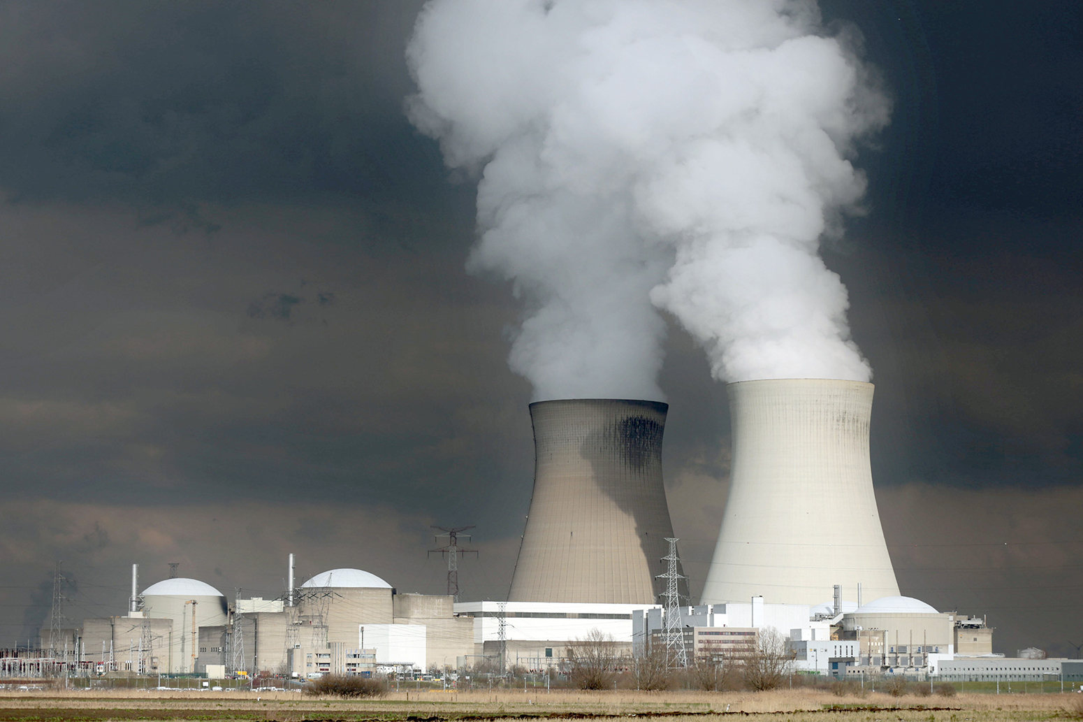
On 01/11/2023 at 20:01, The PIT said:
I've noticed the camera has been moved towards the power station. Good job the power station isn't nuclear. Lava v Power station only one winner followed by a huge bang and widespread radiation. Got me wondering if there are any countries have been stupid enough to build a nuclear power station on a previously active volcanic field. We know one example where tsunamis weren't taken properly into account.
Mapped: The world's nuclear power plants - Carbon Brief
WWW.CARBONBRIEF.ORG
From the latest crisis over Hinkley Point in the UK, to Friday's fifth anniversary of Fukushima, nuclear power plants are currently much in the news.There are a couple off defunct Italian ones between Rome/Naples that could be described as sitting within a volcanic field, but if that field were to become active again, there'd be bigger problems than a nuclear power plant!
Japan is probably the most obvious contender, lots of nuclear plants, lots of volcanic fields, although major earthquakes is the higher risk.
-
2
-
-
On 16/10/2023 at 20:40, WYorksWeather said:
Posting here as well, from the model output thread.
From a cold perspective, SSTs might be starting to look better into early November. These charts start with today's ECM 00z, and step forward five days at a time.
General trend towards more near-normal areas in a couple of weeks' time. I still think we're likely to see some moderation though, and especially any direct southerly to south-westerly winds will trend warm.
Looking at the central med - Does anyone know if abnormally warm sea surface temperatures would be conducive for high pressure, or low pressure, to form around Italy? Low pressure over Italy normally being a key ingredient for an easterly in NW Europe.
-
1
-
-
Evening Everyone,
The thunderstorms over the low countries today have been showing on the met office synoptic charts with a symbol i've never seen before - what does it signify please?
it is a trough line bisected with an open cold front arrow - basically " ----V-----" It's not a convergence line or front axis.
Can be seen on both the 6 and 12 z charts from today.
Many thanks
-
6 minutes ago, Phildb2 said:
Never never ever in my 67 years have I been in a storm like this currently in
Leamington Spa
The lightning detector is crashing on the live radar page from plotting the sheer number of strikes. Came to this thread to see the reports, looks astonishing for the Midlands and earlier for the shires. Will await the photos and vids.
-
1
-
-
3 minutes ago, danm said:
Booooo!
Far too much in FI to be concerned about though...
I'd normally agree with the FI comment but it is very close to mid summer and that chart certainly has all the classic hallmarks of the grot that often materialises in the UK around summer solstice.
Think of all those glasto and wimbledon wash outs, often accompanied with straight northerly feeds that we'd be cok'a'hoop about if it was the winter solstice.
-
3
-
-
20 hours ago, Gray-Wolf said:
Does anyone know the impact of dumping so much methane into the strat?
It's pretty 'dry' up there so it'll not break down as quickly as it does down here in the Trop?
Most would have been burnt during the launch and then I assume a lot of what was remaining combusted with the explosion so while there would be some, it would hopefully be quite limited. The explosion happened a good time after the planned for and failed stage separation, and it is not clear if the booster main engines even performed a shut down, so the booster section shoul have been near empty. Then a question of how much of the Starship vehicles fuel survived.
It does at least use a methane propellant system which is more environmentally friendly than some other fuels, but no rocket launch is ever going to be a healthy thing for the atmosphere.
-
9 minutes ago, DAVE_ALLEN said:
Major upgrade just issued for more snow in the south via updated warning. . @nick sussex this defies the latest fax charts. One can only assume this evenings fax will have a significant adjustment.
I admit I wasn’t expecting a significant upgrade in terms of warnings for the south.
it’s interesting to note. The snow risk has just crept north of the M4 as far as Luton northwards. This northward movement is most likely a result of a deepening of the channel low.
Reading the text, the update is now including ice in the warning, so an element of caution as to any assumption it means more snow. For my location (which was always marginal) any snow has been removed from the forecast and replaced by heavy rain for much of Wed. Such a change to increased ppt for my location however may mean places further north east up into Wilts and Glocs could be in with a better shout of snow rather than snizzle.
-
1
-
1
-
-
16 minutes ago, Nick F said:
There's not been one storm named yet by Met Office / Met Eireann, first time this happened since storm-naming began in 2015 (I think the right year). Think Met Office have given up naming them, even though there's been a few worthy ones for Scotland IMO - instead they let other European agencies name them, such as Storm Otto by the Danish, that brought damage, travel and power disruption to parts of the northeast back in February.
Many thanks Nick, Otto is the one I'm thinking of (that's the one with the power cuts for Scotish Iskands?) Did not realise it was named by the Danish!
-
2
-


Storms and Convective discussion - May 2024
in Storms & Severe Weather
Posted
Alderc 2.0 Starting to think the track is going to be a bit more south and west than expected, moving that line nearer to Taunton - Weymouth bringing Exeter just onto the edge of things, which is last thing i want! I've a piece of lab equipment that is not a remotely happy bunny running with serious thunderstorms or brown outs - usual outcome is i'll have to replace it's power board at great expense yet again! So now having to turn everything off and then unplug, frustrating given i'm half way through a 48hr production run! The second i shut everything down of course, the track will promptly move back to Brizzle-Portsmouth!