


polar vortex
-
Posts
62 -
Joined
-
Last visited
Content Type
Forums
Blogs
Gallery
Events
Learn About Weather and Meteorology
Community guides
Posts posted by polar vortex
-
-
The upstream change back towards the typical winter pattern is now coming into clear NWP focus. Recent posts over the last week or so have continued to use the GWO plots and anticipated next re-initiation of -ve tendency AAM to assess how NWP is likely to evolve.
It has also put the longer term anti-cyclonic picture that was suggested by the models as we headed through the first week of this month to continue through much of February, following the previous amplified phase at the turn of the month, into the expected briefer overall context it now looks to be.
So, GWO heading out of low signalling this week towards quite high amplitude Phase 1 and on its way to Phase 2 and the models are fully advertising the consequent retrogression of the pattern in the Pacific with the pole ward -EPO ridge.
http://www.atmos.albany.edu/student/nschiral/research/gwo/gfsgwo_1.png
The squeezed effect across the US of the jet stream is primed to assist a temperature fuelled gradient as the frigid cold air from the Canadian arctic spills into the Atlantic to make the weather quite a lot more mobile and the north can expect some more wintry aspects of weather with time. Another aspect we have become familiar with at times this winter.
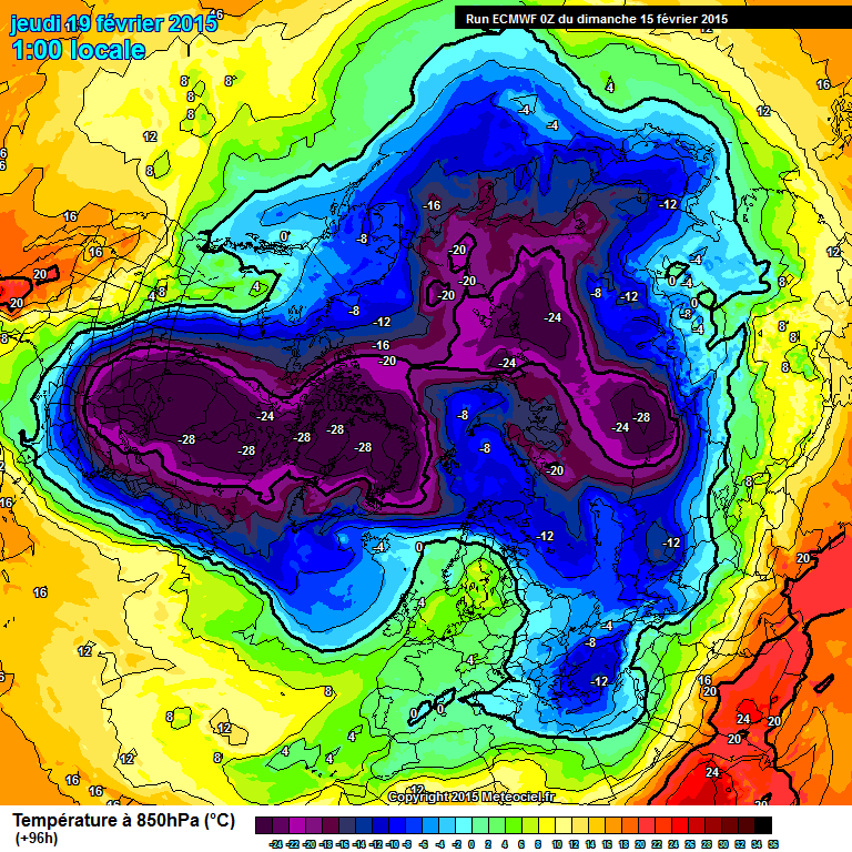
http://www.meteociel.com/modeles/ecmwf/runs/2015021500/ECH0-96.GIF?15-12
With the upstream pattern retrogressing, it is a question of how much amplification feeds downstream. The signal stratospherically, whilst conducive to relocating part of the vortex to our side of the pole as previously posted, is not as favourable as it was in late January, with the Canadian chunk of vortex locked in more upstream - but nevertheless, some vorticity energy transport across the pole as the jet stream intensifies is likely to lead afterwards to another Atlantic amplification.
I think that suggestions that this amplification will not be as long lasting therefore as the previous one in late January/early Feb are correct. However, beyond this we start to head towards the start of official Spring, and it won't be too long after this before a rather different seasonal interpretation of this -AAM/GWO cycle starts to appear
I am very pleased that Vorticity has begun a pinned thread on the topic of AAM/GWO - and his contribution is very well explained as usual

The use of these tools is very valuable in helping to determine extended ensemble clustering and documents daily progress of how well (and how many) members in intra day ensemble suites are picking up on future atmospheric signals.
In this respect it should be no surprise that the GEFS has strongly featured the Azores High signal. The atmospheric pattern has been fully supportive of this as a strong feature throughout the last 2 or 3 months. Its apparent over gilding of the High as a dominant mid latitude block through this month has arisen simply because of the 'Bermuda Triangle' period of tropical MJO modelling.
However, as the extra tropical GWO atmospheric tendency budget incorporates tropical MJO amplitude and movement in its calculations of AAM tendency, then it is the eventual orbit direction of the GWO itself that can be looked to in trying to determine where NWP will finally head after any incoherent signal period.
This orbit direction has consistently shown the next phased re-load cycle of the dominant Pacific pattern - and as now come within the 10 day period, it is set to arrive
Phase 1 is not a high amplified phased state rather the reverse. I see though you have succumbed to the idea of a
more amplified state going forward rather than the rinse and repeat that you were forecasting. To much faith in one
teleconnect can lead to failure.
-
I think there is enough evidence in the model output post t120 to suggest a more amplified pattern
in the Atlantic. Could be quite a potent affair should this happen. Role on the 12z
-
Worth noting that once the pattern flattens out, upstream is frigid and a strong WNW flow is going to provide wintry interest ( more so at elevation of course but not exclusively)
The UKMO model this morning suggests that it may not flatten out.The t144 chart screams north Atlantic ridging
and a much more meridonal pattern. Something to watch perhaps.
-
The UKMO t144 chart is loaded with potential this morning. Certainly the pick of the bunch from
a coldies perspective but with it being the t144 chart maybe should not put to much faith in it just yet.
-
Hate to keep banging this drum, but MJO currently no use as a global teleconnector due to contamination (convective debris from tropical cyclones = phase can't be reliably deciphered nor predicted). Based on the two primary 3+week models (EC Monthly and GloSea5), no useful signal re outcome can be deciphered beyond circa week 1-2 of March, for now at least. Anything otherwise is vague speculation.
Ridge building on the pacific side is more in line with tropical convection around the date line and the weakish phase 8 MJO. Agree with Cohen's
lastest thoughts of a trop split of vortex to what was seen in the strat early January. Also I do not buy into what NOAA and the met and its
forecasting tools say as gospel.
Cold before February is out and then on into March is my bet. The strat has been a thorn in the backside.
-
Still confident of a pattern change last third of the month with much more in the way of northern
blocking as we go into March. This due to tropical convection and MJO signal although the models
are struggling with this. The strat has ruled the roost this winter with very little in the way of
northern blocking ( possibly due to very strong - QBO ) but hopefully we will see a change over the
coming days and weeks.
-
The strong convection near the date line is obviously being modelled to interact with the polar westerlies (PFJ)
in the mid to long range to produce significant ridging up over Alaska and into the Arctic which will amplify
(hopefully ) the ridge in the Atlantic.
I remember American meteorologist L. Cosgrove who often spoke of this when he forecast a plus PNA and
meridonal pattern setting up over the states and the UK.
The GFS 18z run is again locking onto this synoptic outcome.
-
Strong influences from the MJO showing up in the models now with more amplified patterns in the mid range and beyond.
I have been banging this drum for a few days now of perhaps a MJO related pattern change last third of February.
Clueless as to whether it would be from the east or north or indeed something in between but IF it does transpire then the
chances are it could be a very potent affair.
There is an abundance of deep cold in the Arctic and should a dropping AO send some of that our way then we could
easily still be looking at possible ice days, severe frosts and powder snow.The ECM tonight had it gone on another 48
hours would have covered the country in -10 to -12c uppers at least.
Fun times ahead perhaps.
-
A long range straw to clutch at from the 12z NAEFS this evening.
naefsnh-0-0-384.pngnaefsnh-1-1-384.pngCould this be Tamara's GWO induced pattern repeat?
Lets hope the GEM control run has it nailed.
Personally I do not think the model is worthy of band width it takes up, but it shows the effects that MJO forcing
could have on the pattern that has been dominated most of the winter by the strat. I am still for thinking pattern
change last week of Feb but I would not take any notice of GEM, JMA etc even if they show day after tomorrow
scenarios.
-
I am still hopeful that with continued MJO forcing and ridging on the pacific side we will see a fairly
dramatic switch in the mid to longer range output over the coming days. The strat forecasts are
showing a split of sorts from 10mb on down around t240 mark. If the MJO forcing is stronger than modeled
then the likely hood of a full blown split and HLB's is greatly increased.
There is strong tropical convection about 170 degrees west, ideally we would like to see this move further
east into a more favorably phase 8 position ( if anything it has moved a little west the last couple of days
though it has kept its intensity). This is the key I feel to the AO turning negative and producing the pattern
change that most on here are looking for.
-
ECM 12z t240 is a horrid chart for coldies but I am more interested in the greater amplitude shown over Alaska
and north west Canada, again a signal of a stronger MJO wave. Should this continue to increase then we will
hopefully see a more amplified pattern take hold over the Arctic (-AO).
The models are showing no real signs of this at the moment though it has to be said.
-
Another poor run from the gfs 12z for those of us wanting a real taste of winter. The strong ridging shown on the
run up the western side of America into Alaska made no real impact into the Arctic and thus no real impact in our
weather not if your looking for a more blocked and amplified pattern.
The reason for this I believe has nothing to do with the GWO and GLAMM tendency or Enso etc but has everything
to do with the stratosphere in not allowing heights to build into the Arctic. The 12z does suggest a bigger forcing
from the MJO what with the much stronger ridging and although this op run has not shown much of an interest in
northern blocking that is not to say that this run is correct or that this will not change.
-
With the much stronger ridging up into Alaska on 12z run we hopefully will see a much better outcome
in FI. This could turn into a very good run for us.
-
Positive signs on the gfs 12z with stronger ridging over on the Pacific side of north America. This could be very
beneficial down the line.
-
Despite what some say the reason for another poor winter (so far) has been the strength and orientation of the
vortex which again has been underestimated. last year the vortex was stretched from Siberia to Hudsons bay
area and actually allowed a negative AO anomaly of almost 1 SD compared to +1 this january.
I am wondering what with the Jan QBO coming in at -26.70 by far the lowest reading for January since 1979
whether this would have the effect of strengthening the easterly winds around the equator but by being so
strong not allowing them to expand further north as seen below from the 30 hpa mean zonal wind.
Apart from 1 or 2 very brief easterly transitions you can clearly see the dominance of strong westerly
zonal winds.
-
I think any chance of a potent and newsworthy cold spell in mid to long range depends on the strength of the MJO signal.
If we see a strong signal which pushes heights well into Alaska and the Arctic then we are likely to see a trop response
with a much more amplified pattern over the Arctic and a much greater chance of a very cold Arctic outbreak.
The 06z gfs run coming out at the moment for instance shows much stronger ridging into these areas so it wil be interesting
to see where this run takes us.
My money would be on for a stronger MJO response to what the models are showing and thus a greater likelyhood of a
very cold spell in the last week of Feb.
-
Good to see the 06z gfs run really amplifing the pattern admittedly in the far far reaches of FI but
certainly in keeping with my thoughts for the last week of the month.
The forcing from the MJO slowly taking effect on the northern hemispheric tropospheric pattern
although a forcing of the magnitude seen on the 06z would reach well into the strat I would of
thought.
Hoping to see this becoming a regular theme over the coming model runs and ens.
-
From my experience the anomaly charts are not always first to the party when it comes to pattern
changes. Taking them in isolation is not a good practise. Expecting to see a growing trend in mid
to long range for more amplified and much colder northerly incursions.
-
Whilst the ECM is rolling out I want to highlight the GEFS control.
Before anyone says I am merely highlighting the chart below towards all those posts saying "Winter is over", "No chance of snow anymore for low lying areas"!!
Just add how the ECM differs with regards to the low pressure in the Atlantic between +120 & +168 shows our outlook is far from certain. The ECM has this tracking SE into the Med, other models NE into Scandi!
Cracking run and looks like our most potent easterly since 91. I must admit for me when you see a 1040 mb high orientated in such a way as to allow the bitterly cold east/ northeasterly air to push west over the UK there are very few better winter
synoptic patterns.
-
The answer for the reluctance of the MJO to attain higher amplitude is because of the repeated low AAM base state of the atmosphere.
The story of the winter :-
Negative (easterly) tendency in the atmosphere fires up convection in the Western Hemisphere - and hence the MJO signal is at highest amplitude in its earlier phases. Progress of the convective wave is halted by the repeated Nina-esque re-cycling state of the atmosphere, which increases negative AAM tendency in the tropics (manifested as easterly trade winds) . This easterly momentum, pumps up the sub tropical anticyclones, such as the Azores High, to mid latitudes, while at the same time over Indonesia and the Philippines these fresh bursts of easterly trade winds re-fire strong convection which perpetuate restricting the higher amplitude phases of the MJO the 'wrong side' of the globe.
Therefore, each time the GWO cycle orbits through -AAM phases 1/2/3 it drives AAM tendency downwards, re-initialises the low angular Nina state of the atmosphere, and causes the MJO to lose amplitude in its eastwards progress and beat a retreat to where the convection has re-fired once more in the Western Hemisphere.
However, since mid January we have seen atmospheric tendency attempt to neutralise towards mirroring a neutral ENSO state and hence rather more in the direction of the underlying weak El Nino oceanic state (otherwise overridden this season)
The corresponding GWO Phases 3/4/5 to this more Nino like atmospheric signal have just orbited for the second time since Mid January and a second +MT has occurred.
The effects of these +MT's over East Asia are to help assist displacing the vortex to our side of the pole. We have also seen the advantage of this when the Pacific pattern has retrogressed because it has also enabled the MJO to progress rather further at higher amplitude in its cycle as the Nina signal has been, very temporarily, muted.
The GWO orbit however is returning us back once more to -AAM tendency state as the GWO orbits through Phase 0 towards and then through Phase 1.
It is this fresh Nina atmospheric signal which is behind the MJO low amplitude forecasted phase state.
This signal, in beefing up the tropical signal, re-strengthens the sub tropical ridges, and hence overrides the -NAO potential of MJO Phase 8 because the default convection signal is re-initiated.
In truth, with the atmosphere in co-operative state with the ocean (El Nino) we would not currently be looking at a mid latitude high to follow the recent protracted amplification in the Atlantic - but a higher latitude block instead, and no doubt some kind of undercut.
It is in this way that the GWO orbit can give us a guide which way the weather patterns are likely to head. Nina like -AAM tendency does not support higher latitude blocking in the winter months. We are restricted to Atlantic amplifications whilst the GWO is in favourable amplification phasing.
This is exactly what we have seen so far.
However, assumed persistence of this regime into March will start to have different implications.
Shorter wavelengths under -AAM will become more and more conducive to cold air being expelled from the Arctic. Anticipation of increasing amplification through February (the trend has been responsive as suggested since Mid January) leading to better blocking prospects has been based on the atmospheric signal being more and more co-operative for longer and longer each time than we have started to see since the middle of January.
Traditionally this frequently happens in weak El Nino winters and is why they often feature 'end-loaded' winters for cold blocking.
This one is trying hard not to follow the script. However, with two GWO orbits into higher angular momentum territory in the second half of the winter supporting a favourable displacement of the vortex, it wouldn't take too much of a further atmospheric change of signal to lead to much better amplification potential than the seeming nothingness of a string of mid latitude ridges eating up remaining valuable time.
That higher amplitude MJO would be the trigger to improve the holding pattern. Some of the reasons though have been given in this post as to why this is proving stubborn to achieve through this season.
Not sure this is the reason at all.At the present time we have strong westerly wind burst near the date line with strong convection. Easterly trade winds are weaker than they have been plus you can see quite easily on the synoptic models
the amplification over western north America and into the Arctic on the opposite side of the pole.
Stratospheric forcings are probably very much involved but with what I believe will be a increasingly strong MJO signal this may help to override the lower strat signals and we see a tropospheric response perhaps into the lower strat.
Overall I remain very optimistic for the last 8 or 9 days of the month.
-
The GFS has in my opinion trumped the Euro's again this time with the MJO signal. I would not be at all surprised to see a much more
amplified pattern going forward from mid month onwards with the risk of some really potent Arctic outbreaks.
Having said this I would expect the models especially the GFS to be picking this up in its longer output. No reason what so ever to feel
disheartened by the Meto update. Although they have been fairly good this winter they can and do get it wrong.
Below are the last 3 days OLR anomalies. Certainly looking quite impressive.
-
This is the strongest signal I think this winter from the MJO and with the strong convection around the date line
hopefully this will work its magic. The strat lower down looks susceptible for ridging to amplify remembering of
course the more the strat is affected so any northern blocking will be that much stronger.
I have a feeling that we should see more amplified northern hemispheric synoptic patterns in future runs with
perhaps the potential for something much colder than we have seen so far this winter post the second
half of February.
-
Runs this afternoon and evening have definitely toned down the amount of northern amplification that they were showing
yesterday. Only had a quick flip through the GFS ens but they look no where near as amplified either. I did say that they
could be over reacting to a MJO signal and that may well have been the case but the MJO signal remains strong and the
models could well have been to progressive with this. Best to see how the models behave over the next few days rather
than speculate on rinse and repeat cycles etc.
-
The GFS has consistently shown an area of snow moving down from the wash around 4 am in a south westerly direction
giving roughly 3 to 4 hours of snow with west cambridge, bedfordshire and hertfordshire in prime location
before the snow continues to weaken as it moves further south and west.
You can see this quite cleary on the high res 0.25 degrees on meteociel. Temps, dew points and 850's
all look conducive for lying snow. If this proves accurate then I could see some places getting 5 or 6cm before
it peters out.


Stratosphere Temperature Watch 2014/2015
in Spring Weather Discussion
Posted
I think -QBO works well with low solar and moderate Nino however if the QBO like this winter is to negative this can have
a detrimental effect towards northern blocking. Just my opinion of course.
One other point that may or may not be of relevance regarding the winter of 62/63 during the October of 1961 the largest
detonated nuclear bomb (the Tzar bomba or king of bombs) was dropped over Novaya Zemlya with a yeild measurement
of 50 megatons. This would have surely had a impact on the stratosphere remembering of course that the March of 62
was very cold with extensive northern blocking. Maybe this had repercussions for the following winter as well.