


Paul Sherman
-
Posts
8,809 -
Joined
-
Last visited
-
Days Won
26
Content Type
Forums
Blogs
Gallery
Events
Learn About Weather and Meteorology
Community guides
Everything posted by Paul Sherman
-
Latest AIM is a beauty for tonight - Shame lots are clouded out tonight bah
-
Storms and Convective discussion - 1st June 2020onwards
Paul Sherman replied to Supacell's topic in Storms & Severe Weather
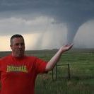
Well I did say South of Gatwick earlier and this was just South of there Not my Pic btw - Should have made the trip down there though after chasing in Suffolk and Essex yesterday
-
Storms and Convective discussion - 1st June 2020onwards
Paul Sherman replied to Supacell's topic in Storms & Severe Weather
Area to watch is Ashford and Gatwick southwards from there Pretty decent chance of Funnel Clouds today so keep em peeled down there -
Very Weak Display over Essex this morning - Meh Gutted I missed the morning before
-
Very faint display around 1130pm in Essex then vanished
-
Could be an early show for once and not the 2-3am lol
-
Storms and Convective discussion - 1st June 2020onwards
Paul Sherman replied to Supacell's topic in Storms & Severe Weather
Clear Skies above but cloudy out east - Have a clear view towards Holland and Belgium from here. -
Storms and Convective discussion - 1st June 2020onwards
Paul Sherman replied to Supacell's topic in Storms & Severe Weather
Lol I must be the closest to that storm due east of me and even I cant see the lightning - Pmsl -
Storms and Convective discussion - 1st June 2020onwards
Paul Sherman replied to Supacell's topic in Storms & Severe Weather
The Cone of Silence (SE Essex) somehow managed to dodge the showers as well today, most were west, quite a few to the North and South and some off the estuary to the east. Rainfall received was once again Trace Value -
Storms and Convective discussion - 1st June 2020onwards
Paul Sherman replied to Supacell's topic in Storms & Severe Weather
Lol dont worry SE Essex Is in the Cone of Silence. Everything slides to our east and to our west. Its like the Cha Cha Slide song here -
Tornado threat 18th March onward
Paul Sherman replied to Kirkcaldy Weather's topic in Storm Chase USA
Saturday and Sunday still shaping up to be the season savers by the looks of things. Should be the first Moderate Risk issued for either day since the last week of April. Some of the soundings are showing some violent tornado potential in parts of South Dakota on Saturday One to watch........ -
Storms and Convective discussion - 1st June 2020onwards
Paul Sherman replied to Supacell's topic in Storms & Severe Weather
Sunny and Warm in Leigh On Sea with high level cirrus -
Storms and Convective discussion - 1st June 2020onwards
Paul Sherman replied to Supacell's topic in Storms & Severe Weather
But can you see it -
Tornado threat 18th March onward
Paul Sherman replied to Kirkcaldy Weather's topic in Storm Chase USA
VERY Active period coming up in the USA and more especially the Northern Plains. Starting today with a frontal boundary storms should be focused through Minnesota and parts of Wisconsin and Illinois. Much better risk on Thursday and Saturday coming up in Nebraska. Then the 500mb flow is looking favourable from the 6th until the following weekend across Co/Ne/Wy/Sd and some of the Central Plains. At least some interesting weather to follow through the riots -
Hit the Road yesterday evening and set up along the North Norfolk Coast. First signs on Camera and not to naked eye were at 1140pm straight North. The an amazing display from 0015 to 0255 clearly visible to the Naked Eye. The first bank of cloud moved off to the North West but the best display of the night appeared in the North East and rose higher into the sky as the onset of Sunrise approached.
-
Best storm you've ever seen in the UK
Paul Sherman replied to James1979's topic in Storms & Severe Weather
17th July 2004 - Supercell Thunderstorm in Essex which initiated in Surrey and dropped a Tornado near Lowestoft. Got pummeled with Golf Ball Sized Hail at my location and put quite a few in the freezer for days to come. 5th August 1981 the Day Darkness Storm over Chelmsford which followed a 7 hour Plume event the night before which I now probably know of as a Supercell. Think I have seen a paper which showed tops on that storm were over 45,000ft Alas since chasing in the US every year since 2004 nothing really does it for me in this country but would love a storm to prove me wrong 1 day -
Was gunna say but not to be pedantic its 5 or 6 days away not 7 lol
-
Tornado threat 18th March onward
Paul Sherman replied to Kirkcaldy Weather's topic in Storm Chase USA
Stat Fact as well if the SPC dont upgrade to Moderate today then it is almost certain this will be the first ever May that no Moderate or High Risks have been issued by the SPC since they started doing the Risk Levels. Abysmal Year for sure -
Tornado threat 18th March onward
Paul Sherman replied to Kirkcaldy Weather's topic in Storm Chase USA
And most of those are double or triple reports - Shocking Month could even be actual figures below 100 -
What sort of Camera settings you doing for that picture please Arnie ? Is it Low F Stop and Medium range ISO ?
-
Tornado threat 18th March onward
Paul Sherman replied to Kirkcaldy Weather's topic in Storm Chase USA
Actually with the boundary now stalled and clear skies this is looking better again around the Wichita Falls areas 2 Areas of Interest today OFB in North Texas Cold Core Tornadoes in NE Kansas and SW Nebraska -
Tornado threat 18th March onward
Paul Sherman replied to Kirkcaldy Weather's topic in Storm Chase USA
No chance of an Upgrade already been downgraded These are pants risks when you have a crashing boundary surging south - The one at the start of May and in week 2 both busted and with absolutely zero upper winds theres no reason why this one wont as well. And after today a small risk in Illinois and thats yer lot until June Very Poor Season and Covid has probably saved us this year - Tour 1 and 2 would be Tornado less this year for the first time since 2005 -
There should be some good ones in SW Kansas tonight if you look to your west
-
Fanks In the words of Duncan Bannantyne I'm ooot
-
Got any Charts to share Harry ?


