


comet
-
Posts
264 -
Joined
-
Last visited
Content Type
Forums
Blogs
Gallery
Events
Learn About Weather and Meteorology
Community guides
Posts posted by comet
-
-
13 hours ago, Raythan said:
Is this a trop led split ? Upwell?
For the most part this is almost certainly a top down forcing. You can easily see this on the instant weather maps.
The late Jan 2009 warming and split was in a similar locale and had an almost immediate trop response, I see no reason why this should be any different. We may only be a couple of days away from some mouth watering charts to start appearing in the model thread. I must admit my expectations are very, very high.
-
 1
1
-
-
History shows us that our coldest winter weather has come from strat warmings (not all I know). The warming and split being modelled is almost off the scale and if we are to see a severe winter cold spell then this is what you would need and want to see.
-
Berlin strat charts already showing a split at 100mb t240 therefore what we may be seeing in the trop is a transferal of energy from west to east or in other words the strat forcing temporarily interfering with our cold pattern until thing become realigned and we see major heights building north unleashing a very cold (perhaps bitterly cold) second half to February and then on into March.
Never the less a interesting week coming up.
-
 3
3
-
-
Temperature wise on SUNNIER days I have found that 850's +10 during December and most of Jan. Early feb 850's +11. By third week in Feb 850's +12 and into first two weeks of March 850's + 13. By the time you get to mid April 850's + 15. On thick cloudy days even in March it may only be 850's + 11. There are exceptions ie during very cold March 2013 on 22nd march here in Hertfordshire with cloud cover and light snow at times and 850 temps of just -5c we only saw a max of -1c due to very cold surface air at 925mb that had made its way over from the continent.
I have gone for a cet for Feb of -2c so I am expecting a ferocious beast from the east later in Feb with the vortex setting up home of central northern Europe hopefully. Brilliant model viewing at present but I think there is much better to come courtesy of strat, MJO etc.
-
2
-
-
Cet of -2c please.
-
1
-
-
I for one have for some time been calling end of Jan and then on into Feb for cold weather with the strat and MJO playing ball with east / north easterly airflow. As late as early yesterday was thinking this was a poor call with mediocre upper temps and similar wet snow, slushy fest away from high ground. The last 24 hours has seen a fairly substantial upgrade although not sure if ecm is over doing it a tad.
Whether we stay locked into a cold pattern as the ecm is starting to suggest or there will be a temporarily relaxation one thing I do known if the warming and split that the gefs have been modelling comes off ( There is every likelihood that it will) then what we may see in the second half of February could be the like of which we have not seen since Feb 91 or Jan 87 both in terms of snow and depth of cold. That is a long way off for now though and plenty to keep us entertained in the meantime.
Happy days.
-
I don't know how many times this winter the phrase fascinating model watching has been used yet here we are at the end of Jan with precious little to show for it, and for many nothing at all to show for it. The output for the next week or so looks to again deliver very little unless your up a mountain or in one or two of the more favoured areas if your lucky. For the rest some sleety wet snow if your lucky and a few frosts.
Here's hoping to the mid month strat induced vortex split and MJO phase 8 assist to lead us into a potent last couple of weeks of winter and hopefully something memorable to take from winter 17/18.
-
5
-
-
1 hour ago, jvenge said:
Begs the question....
Who would actually want one mid feb?
A proper beast would deliver the coldest uppers and surface cold although that may not necessarily be true for Scotland.
-
1 hour ago, Chris101 said:
The only place i've seen any consistency in the Gfs over the last couple of days is in the 18's, the rest have been as others have said, all over the place.
I know they have been very cold runs, but a usual watered down version would still bring the goods, i do like it when Gfs shows really deep uppers early on, it gives a bit of play.
Anyway, i shall have a keen eye on tonights 18z and hope they have some resemblence to the last couple.
The ECM operational has been just as bad as gfs imo no consistency at all, and tonights run looks no better.
-
1
-
-
The 06z has really toned down the strat warming at the end of the run, I know at that range it is very inconsistent. The last several runs have shown the warming intensifying and then out comes a run with very little warming at all lol.
As far as the possible easterly developing in about 8 days time we really want to see future runs build on this is there is to be any chance of this coming off, otherwise we may have to wait until later in the month. imho i do think we will hit the jackpot next month fingers cross
-
11 hours ago, comet said:
Very disappointing to see the downgraded strat warming by the gfs and to some extent ecm. This at one time was modelled to really bolster the Russian high and Pacific ridge into the Arctic. This has now been toned down to some extent which is not good news imo although I would not be surprised with the recent poor modelling if the warming was forecasted to strengthen again in coming runs. Just my opinion of course.
A post I made last evening and low and behold a few hours later the 0z shows us what can be achieved with stronger strat forcing (warming)and I would imagine a stronger MJO signal.
Much more amplified pattern on the eastern side to link up with amplified Atlantic ridge While very cold air avected westwards. Fingers crossed.
-
2
-
-
Very disappointing to see the downgraded strat warming by the gfs and to some extent ecm. This at one time was modelled to really bolster the Russian high and Pacific ridge into the Arctic. This has now been toned down to some extent which is not good news imo although I would not be surprised with the recent poor modelling if the warming was forecasted to strengthen again in coming runs. Just my opinion of course.
-
1
-
-
26 minutes ago, feb1991blizzard said:
Its just a slight displacement if you look at the charts showing the vortex, http://www.instantweathermaps.com/GFS-php/strat.php?run=2018012406&var=HGT&lev=10mb&hour=135 if you run the chart shown on the MOD thread through you will see the warming just fades away. its still better than not having the warming at all because it still slows the zonal flow down up top which makes it less likely to affect the trop meaning the trop can do what it wants, unfortunately though BA' posts above that there is an increase in zonal flow in the GEFS members in week 2 and even looking at the op there wont be a technical SSW anytime soon (reversal at 10mb), however, we may not need one though as some interesting output in the trop has been showing in week 2 lately anyway.
The warming is the reason for the strong Pacific ridge that moves into the Arctic. This could play a very important role in getting deep cold to the uk if we get strong support from the MJO. Think 12/13.
-
1
-
-
1 hour ago, bluearmy said:
no discussion that a strong strat vortex and consequential zonal flow will make sustained HLB nigh on impossible. i'm just not sure if you are saying the strat is part of the cause of HLB or just not interfering destructively with the trop developing them. one is passive and one isn't.
the ec op is evolving exactly as suggested yesterday evening re the mean and anomaly. I hope we aren't headed towards another 'warm easterly' !
Yes of course it is part of the cause of HLB. Strong forcing Pacific side with heights, MJO forcing contributing aiding ridging on Atlantic side. Continued strat forcing ( warming) helping to force split ( IF we are really lucky). Thinking of Jan 2012/13 warming here and subsequent blocking although this time round HLB may be more robust.
-
8 minutes ago, bluearmy said:
The MJO analogues for 7-8-1 have no adjustments for the state of the strat,. are you simply saying that because the strat is looking fairly benign, it wont interfere with the HLB signature which would follow MJO 7-8-1??? the split mid strat vortex showing on the gfs op post day 13 is certainly not reliable. one thing i've noticed over the past weeks is the trop signature sometimes mirrored right up to 30hpa on ecm days 8/10. at 50hpa, its often. the next run, if the op is different in the trop, the mid strat pattern is also different. that's not something which in previous winters is so evident above 70hpa outside of the sustained big features (like a Aleutian ridge)
Rightly or wrongly I believe that without the strats c/o ie the top down forcing and warming we are seeing to weaken the vortices you would not see strong HLB's even with a phase 7-8 MJO response.
-
3 hours ago, bluearmy said:
can you expand on the strat forcing and how it will influence the pattern ?
Was at work so could not reply immediately but yes basically the strat forcing that we are seeing in the charts will precondition if you like the strat so that IF we do get a strong MJO phase seven - eight - one response instead of minor ridging we would likely see strong HLB's that would last for several weeks perhaps with the Uk very likely to see some potent cold spells. The 06z run showed split vortices up to 10mb. Have not looked at the 12z yet.
Also if you pop along to the strat thread you will find much, much more helpful information to get you started.
-
2
-
1
-
-
Stratosphere forcing along with respondent MJO phase calling the shots from mid range onwards. End of Jan onwards into February big, big change in the weather as I have been saying for some time now. All other teleconnects like playing cards,will fall into line.
-
1
-
-
It could all go pear shaped of course but the GFS runs seem to be getting their act together with regard the strat warming. After a week or more of downgrades the runs now seem to be consistent or even intensifying the warming and we are now talking about the 10 day range not right at the end of FI.
The change to cold or very cold for the end of the month onwards into Feb could be starting to gain momentum again. although this could be due to the model seeing a strong MJO phase 7-8 response but we know how unreliable these forecasts have been throughout the winter so far. If we do see a strong MJO response then watch the other indices such as GWO, AAM etc falling into place.
-
1
-
-
13 hours ago, KyleHenry said:
I’ll save you some time.

https://www.nasa.gov/mission_pages/sunearth/science/magnetosphere2.html
https://www.space.com/6229-earth-atmosphere-breathes-rapidly-thought.html
Look at the working mechanism of the PV.
The Tropopause and the stratopause are fluid are not only in geographical position but also in heights. Similar to a hurricane, the PV strength/weakness relies on convection. The lower the temperatures that both can attain then the stronger the inertia to be broken down.
The mesophere has been measured by satellites to expand and contract. Hence why I give my hypothesis as to the whys of this winters characteristics.
I to have read about the effects of protons on the mesosphere. The sun has been very, very quite so far this winter unlike winters in the past like 62/63 for instance, that had much higher solar levels and undoubtedly much higher proton absorption in the mesosphere along with 78/79 etc etc.
To Just assume that this is the reason is quite frankly wrong. Also as Interitus pointed out the stratosphere has very little in the way of water vapour.
-
As others have said little sign in the output at the moment of any Atlantic mid latitude highs trying to ridge north. Do not for one moment believe though that this is because of low AAM or Nina signal that would be plain wrong. From what I can see at the moment is that wave 1 forcing is pushing the vortices down towards our side of the pole from the Pacific and without really any wave 2 response despite being told heights over Alaska and Scandi are conducive to wave to propagation going forward (another red herring) we would really need to see a strong phase 7-8 signal in the mid to long term.
-
2
-
-
46 minutes ago, KyleHenry said:
Many, including myself have been scratching our heads as to why this winter, when the conditions have been so perfect for a loosening of the Polar jet and expansionism of cold air into the lower latitudes has not occurred.
Signals consistantly showing via the models of HLB in Scandinavia & Greenland, yet failing to materialise each time in terms of predicted longevity.
MJO entered sector 3 which is now culminating in EAMT event=Stratospheric wave 1 and yet as we approached finalisation point it has decreased in amplitude.
No SSW, merely elongation of the PV which does show that even a weaker wave will create enough stress to contort vortex and allow intermissional cold break outs at the Tropispheric level. Just that unless sustained pulses/waves occurs, then it will return to default position.
Why so?
That we are still on the decent to solar minimum. With that said the sun is continuing to emit bursts of protons/cm3. Negative NAOs struggle to develop in these conditions. Hence the failing of current wave to split PV.
Geomagnetic bursts charge the magnetosphere add expand it outwards. This permits all levels to elongate and acts as a dampener to wave pulses. The PV has additional upward momentum and hence becomes more taught adding strength.
Sorry do not buy that at all. That is one hell of an assumption with very little proof if any at all.
-
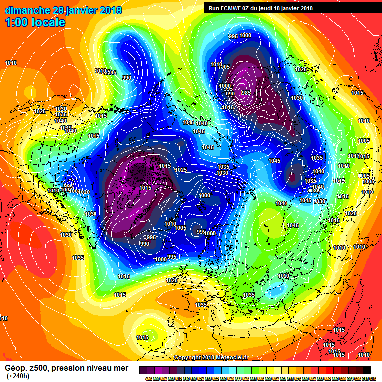
2 hours ago, beng said:
I reckon this 240 hours chart from ECM will be along the right lines in terms of the broad pattern. Assuming the MJO forecasts are to be believed we'd be somewhere around phase 6 towards the end of the month - which would favour high pressure developing around the UK - so expect the high to our South to edge northwards after this 240 hour chart.
If we then progress into Phase 7/8 - which is quite possible/likely (we did do during previous cycles this winter/last autumn - http://www.bom.gov.au/climate/mjo/) - then there's every chance that this will develop into some kind of Scandi block which then retrogresses - I'm thinking along a similar time frame to Feb 1991 - whether it packs any punch remains to be seen, but this winter may have a final kick to it.
http://www.cpc.ncep.noaa.gov/products/precip/CWlink/MJO/foroper.shtml
Basically we can forget about January (although it's been decent for some), but February really does like quite promising for now.
I have been touting the likelyhood an East/northeasterly due to strat/trop forcing towards end of Jan into Feb for a while now, but it really all comes down to the magnitude of the mjo forcing and strength of wave1.
-
3
-
-
Dire output from the models this morning if it's cold your after. Slowly and quietly the models have down graded the Atlantic ridge and reverted to the dross they were showing last weekend.
-
3
-
-
Here's hoping the ecm 12z does not verify (not that it will anyway). The last thing we want is to be chasing toothless easterlies with little chance of verifying. Hoping for something far better than that even if we have to wait a wee bit longer. Certainly not the most positive afternoon and evenings model watching from a coldies perspective that's for sure.
-
1
-


Model output discussion - proper cold spell inbound?
in Forecast Model Discussion
Posted · Edited by comet
Tweets from I.F a few days back coupled with model support for much colder weather as we go through next week with risk for disruptive snow has been somewhat muted now. I am convinced this change is due to the overriding forcing and downwelling from the strat. If the strat profiles are anywhere near correct they show the possibility of part of the polar vortex dropping into central Europe and the split to the north and northeast of the UK. The transfer of energy will mask the teleconnects for several days.
Without the strat forcing we may well have seen a cold, very cold spell for a week of so but the possibilities of what could be around the corner may well be far more potent and severe.