


J-Man
-
Posts
109 -
Joined
-
Last visited
Content Type
Forums
Blogs
Gallery
Events
Learn About Weather and Meteorology
Community guides
Posts posted by J-Man
-
-
First showers starting to form.

-
I normally have to head to the hills for my winter hiking but next week the dunes around alnmouth will probably be just as challenging.
-
30 minutes ago, Hagler said:
I think people have been panic buying bread in Consett today! ?
Probably been snowing in consett since September and those shelves just haven't had a delivery to be replenished.
-
 1
1
-
-
Noticeably colder wind chill this evening.
-
25 minutes ago, gordonm said:
where about are you on coast J-man? im about 4 miles in from druridge bay, yea 2010 was last time we had decent snow. we totally missed march 2013!
Amble, you must be Widdrington or maybe Acklington?
-
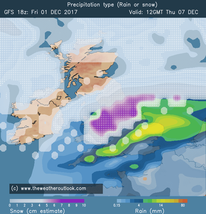
10 minutes ago, Summer Sun said:
Estimated snow totals to Friday
I really think that figure is massively underestimated. 15cm totals over a 4/5 day period? The latest BBC forecast was warning people to be prepared, stock up etc due to the snow potential. 15cm over that period wouldn't cause that much disruption, councils would be able to keep on top of it.
Place your bets. I'll go double that as minimum.
-
2
-
-
1 minute ago, 4wd said:
There won't be as much as December 2010 though because then winds were more from NE with longer fetch to pick up moisture, and sea was at 10C or higher not 5C.
Also this spell can't last for weeks as spring advances.Yeah but the uppers are colder so the difference between that and sea temp should be close to 2010. Also stronger sun = more convection and the fetch from Norway to our area or say Netherlands is neither here nor there. Maybe im being over positive time will tell.
-
1
-
-
1 minute ago, gordonm said:
hope you're right J-Man!
Every met forecast (website) for my area over past few days has shown an upgrade in terms of snow, looking at relentless snow falling over 3 day period. Even as showers the breaks between would be shorted lived. I am personally expecting record snow fall for my area of the Northumberland coast....we dont often get much 2010 was a special time but think we'll beat it in 2018.
-
2 hours ago, Geordiesnow said:
I don't know how in God's name that chief forecaster would suggest some places may only receive 1 to 3CMs especially not in the North East in any case. 2 to 3 days perhaps of the classic sunshine and snow showers set up, radar should be rife with PPN especially midweek.
Got to say though for south eastern areas of the UK because the winds are switching more to a ESE'LY then they might not receive as much as they might think!
Completely agree, the NE coastal area will be knee deep...1-3cm...no chance. Whitby will be cut off as usual, Consett will have drifts up to people's windows and the A1 in Northumberland will be blocked from Morpeth north to Belford.
-
1
-
-
Ive done very little since Friday except model watching and my head is done in. After the 18z GFS comes out it'll be break time for a couple of days then see how things develop on Wednesday.
-
The low sits over the North Sea for 4 days, feeding in snow. This is "potentially" going to be a period to remember. ECM on board although with the low slightly more North East but still giving us what we crave.
-
Just now, MKN said:
Given the type of scenario we are dealing with this wouldnt be guarenteed at +48 let alone +132.
I think the gfs has been quite reasonable over past 5 weeks, yes things drop in the drop out then back in again but so far this autumn its generally been on the ball with the patterns. Lets hope it continues over coming month.
-
Just 132 hrs from now.
-
1
-
-
2 minutes ago, Winter-Chaser said:
that"s yesterday's 18z
Too keen, too excited...apologies.
-
1
-
-
2 minutes ago, winterof79 said:
Really??Not any that influence our weather
-
The low on the 18z looks even deeper.
-
Surface sea temps in the north sea are lower than average thanks to the cold November, this will only have a positive impact for any potential snow event for coastal areas next week.
-
1
-
-
2 minutes ago, I remember Atlantic 252 said:
hover mouse over word, can see it means fantasy island, meaning super unreliable chart so far ahead it won't happen
Great thanks.
-
Im pretty new to all this is there any where I can find a list of what all the acronyms stand for....the one that I cannot work out which I see the most is FI.....
-
First area of white showing on west side of Scotland, long may it last. Looking at models we should (fingers crossed) see whiteness develop over northern uk in coming weeks.
-
Its also encouraging that the models predicted both the pre Halloween cold snap and now this bonfire night one. Both were showing at least 7 days in advance which is a complete turn around to recent years.
-
7
-
-
Did it snow in London one late October in maybe 2009/2010....can anyone find the chart, if they can verify that it did snow, so we can compare that to this potential cold snap.
-
All quiet in northumberland. according to the models we get it tonight.
-
Fingers crossed nothing horrible happens to anyone tomorrow, good night.
-
3
-


Far north and northeast of England - regional chat
in Regional
Posted
The showers forming over north sea are already a snow/rain mix so no concerns from me that they'll be anything but snow when arriving on our shores.