


Georgina
-
Posts
158 -
Joined
-
Last visited
Content Type
Forums
Blogs
Gallery
Events
Learn About Weather and Meteorology
Community guides
Posts posted by Georgina
-
-
- Popular Post
17 minutes ago, Tim Bland said:No disrespect but why don’t people decide for themselves ? You don’t even have to be able to read charts when people like me post temperature and precipitation type charts

Because it’s confusing and when you’re learning you have very little confidence in what your thinking yourself so you watch and read and learn , when people put “it’s awful” you start as a novice to question yourself and what you’ve learnt , it’s just helpful that’s all , I thought this forum was about being helpful and learning and helping others especially when the models are so up and down ! No disrespect taken ,Thankyou for taking the time to reply

-
 20
20
-
 1
1
-
I really dont understand how some people say ecm is great tonight and has come into line and some are saying it’s awful , please can people say why it’s awful I understand everyone has different views but it would help if they actually explained there opinion and views ! Sorry to moan xx
-
5
-
-
2 minutes ago, Kasim Awan said:
Yes I agree with first paragraph but ecm is a hyped model
Too slow to react and too cautious most of the time
It needs a rewrite. Are you up for some intense maths
Not at 7.24 in the morning I’m not I dislike maths at the best of times !
I do agree that the ecm seems very cautious but sometimes that’s not a bad thing Xx
-
1
-
-
I have very very little knowledge not like you guys at all , but from watching the models for a few years it’s nearly always the gfs that comes into line with the ecm !
If we have a stubborn ecm it usually ends with the gfs downgrading and the ecm slightly moving towards the gfs to meet in the middle !
of course I’m probably wrong as I say not as experienced as you guys
-
4
-
-
2 minutes ago, Lord Baltimore said:
Plymuff
Muffborough
-
1
-
-
6 minutes ago, weathermadbarnsleylad said:
Hi the main model run is the black line(gfs main model) on the graphic. If you look towards the left you will see it divert upwards away from the other lines( The other lines are the main models I will say brothers or sister for easy (ensembles)that predict outcomes from the data it's got .Same has the main gfs main model run does(blackline) the outlier part means it has moved away on its own from what its brothers and sisters are saying. Its not to say its wrong but the other brothers and sisters don't go with it. Tried to explain lol. hope it helps..
Thankyou I understand now thanks
-
1
-
-
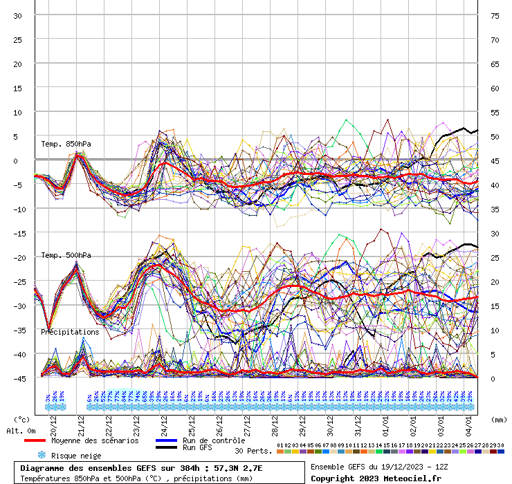
4 hours ago, Ravelin said:
Looking at the GFS 12Z 850 ensembles for my location, which will be much more favourable than most is interesting...

There is slightly less scatter than there was on the earlier GFS runs but still a lot more than yesterday, and starting at a relatively early point. What I often find more useful though is the box plot version...
The first obvious observation is that the OP is an outlier, in the true sense rather than how 'outlier' is often used on the other thread, from around the 30th onwards. Secondly, look closely at the lower 10-50% quantiles and out to the end of the 31st they are much more tightly grouped than the upper 10-50% quantile. That's indicative that there's much more grouping going on in the colder ensembles than for the warmer ones. Hopefully that means a greater chance of the cold options winning, but then again the 'outlier' OP could be the winner, such are the vagaries of the weather.
This may be a stupid question but how can you tell if the op is an outlier and what does that exactly mean does it mean that it’s not worth looking at ? Thanks and sorry for the daft question xx
-
1
-
-
Well I for one am very confused by the other thread
-
3
-
-
9 minutes ago, bluearmy said:
Icon refusing to jump is a concern for coldies ….. it usually sides with the euro models
Why is it a concern please ? xx
-
2
-
2
-
-
Hi everyone
I for one hope the trends south stop around the uk mid way latitude Still good momentum for the snow event as far as I can see
Enjoy the ride xx
Georgie
-
1
-
-
1 hour ago, snowking said:
~15.15 Icon rolls out, doesn't show what any coldie wants it to, gets disregarded as cannon fodder
~16.00 GFS & UKMO rolls out, GFS op shows a full blown Easterly, is declared the "Greatest Forecast System" ever assembled, cold spell declared, Daily Express starts preparing the Caps Lock key for a battering. UKMO not on board but rightfully ignored.
~16.45 GFS ensembles are analysed, nobody as a clue what is going on
~17.00 Jules finds 4 bad ensemble members, has a moan
~18.00 ECM starts to roll out, everyone looks to Sheiky for a "steady as she goes at T+0" post
~18.45 ECM sits somewhere in the middle of the envelope
~20.00 Everyone asks Bluearmy and Mulzy what the clusters are showing
~20.15 One of them dashes all of our dreams as the clusters prove inconclusive
~22.00 GFS 18z rolls out, is completely different to 12z
~04.00 the overnight crew takes over, are usually downbeat.
Rinse, repeat.
It’s like a net weather advent calendar
-
4
-
-
18 minutes ago, Severe Siberian icy blast said:
A snowy ECM run and in all honesty the knee jerk reactions this morning I read at 6am considering the charts was enough to put me in a mood simply because I don't understand why people are so emotionally driven at a chart that shows sliders coming into cold air, yes this morning everythings a few hundred miles for North, but why you getting hung up because your in the milder air on a chart that's 7 days away!
Look for key points, high pressure to the North, cold to the east, sliding low pressures, the finer details come much nearer the time and with sliding lows it's the last 2 or 3 days max you wanto be looking at the rain/snow boundary.
I can only think some of you enjoy the emotional day to day runs but it's not healthy! What ever you do, NEVER do inter day trading online if your emotional it will destroy you!
Have a good day gang


This is a fantastic post From a newbies POV , really positive and telling us what to keep an eye out for Thankyou
-
2
-
-
Hi everyone x
I can certainly see a promising set of 12z runs from Derbyshire, not sure everyone else shares the same view
I’m certainly no expert but I feel it's too early to get caught up on snow past fantasy point which according to other posters is around 168h
If it can change it will and who says it wont be in our favour ! Honestly, save yourself some worry for the festive periodGeorgie x
-
8
-
1
-
-
- Popular Post
- Popular Post
Ok so the first technical post from me, lets see what I've learnt
The models are still clearly struggling, so anything after 168 hours has to be taken with a pinch of salt as do any snow details. Have scrolled through a fair few pages of pure worry about snow 200 hours away
It's clear that there's been a big shift in the last 24 hours in favour of us coldies, though there is still big uncertainties as this is against climatology big time, models will underperform, so no point throwing abstract percentages around, nor taking op runs as gospel
- Don't worry about what you can't control. So let's just sit back and enjoy the ride.
Georgie xx ❄
-
29
-
3
-
6 minutes ago, CreweCold said:
Agree, I'm confused on this forum when I read posts saying bad charts are good and decent charts are hideous
Well if you’re confused there’s no hope for me
-
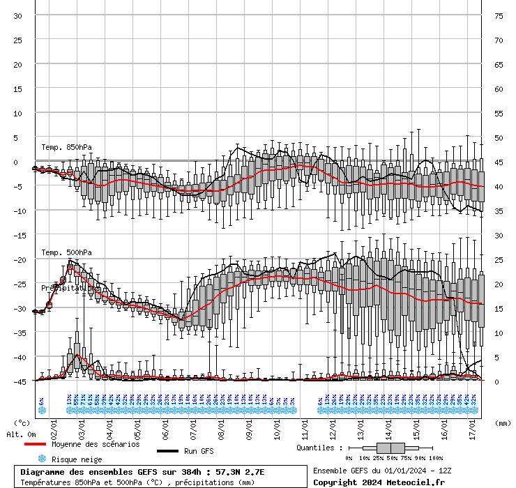
5 minutes ago, LRD said:
While we await the last frame of the ECM, here is the impressive 850 ensemble graph from the GFS 12z
Let's hope the control is very, very wrong in FI
Sorry could you tell me what the graph shows please ? Obviously there’s a lot of scatter that I can see but what does this mean ?
-
2 hours ago, badgerhud said:
So from what I can see it's going to be a below average Christmas with little or no precipitation. Beyond that it's likely to get milder and that's backed up with the Met Office 30 day forecast. I think they'll nail it to be honest
Can you back this with charts please ? So we can see where you get your thoughts from ? Thanks
-
1
-
-
On 14/12/2021 at 06:35, swfc said:
It's just a saying. Could have been Rotherham
I’ve never heard that saying before thanks for clearing that up
-
On 14/12/2021 at 06:19, swfc said:
The dry theme continues while Eastern Europe goes into the fridge. Possible split PV via the Arctic ridge in fi but usual caveats fi etc. Dry and frosty festive period looks a good bet on anything white. You can live in hope or die in matlock, so who knows
Die in matlock what’s wrong with Matlock
-
1
-
-
On 13/12/2021 at 21:22, northwestsnow said:
Never a pain to ask..
Basically ecmwf is promoting a - NAO over Xmas and new year .
Ties in with ec46 and is good news if you want cold .( I'm guessing you do ).
Thankyou for explaining , yes I’d love some more cold and snowy conditions especially over the Christmas period ! But I do know it’s very difficult for our little island to be able to get snow so I’m crossing everything at the minute x
-
2
-
-
On 13/12/2021 at 20:58, Met4Cast said:
This is about as strong a signal as you can get for a -NAO event.
A strong signal for the high to back westwards through the Christmas period and towards the New Year. As far as cold spells for NW Europe go, at this range, you couldn't ask for a stronger signal.
Hi sorry what are those charts you w posted ? And what signal
am I looking for ? Sorry to be a pain x
-
1
-
-
On 10/12/2021 at 19:25, MATTWOLVES said:
I will raise a glass...to hope to all good men and woman of course.
It can get a little fickle at times in here,a bit like a football forum when your team loses...get a win and things are great...a couple of setbacks and its the end of the world...sack the manager,get a new team!
The analogy being we don't know for sure regarding the build of heights next week will hold....sink...or migrate further North...we can only assume on current guidance what the models hint at each and everyday...They may hint it sinks today...come Saturday they may hint it pushes NW,and come Sunday....it pushes NE.
Absolutely no point in painting the worse kind of picture at this early stage..
Like me old nan used to say....Matthew....get the Heights over us,and then watch em pull North...mind you she used to have conversations with a stuffed rabbit..
Pretty good ECM..all options are on the table...now get out there and have a drink for me!
Fab weekend to you all
Thankyou for your easy to read posts and for being so dam cheery
-
5
-
-
On 09/12/2021 at 17:01, Kasim Awan said:
The progression on the gfs is actually very similar to Dec 20th to Dec 26th 1962.
What happened in that period of weather ? X
-
1
-
-
On 06/12/2021 at 20:37, Griff said:
Hi sorry to ask but what is this ?


.jpg.bf1e7d479da52ada313f887abf980047.jpg)
Model discussion - hunt for cold - Christmas countdown
in Forecast Model Discussion
Posted
Merry Christmas , Sometimes there’s more important things in life than the weather , I hope you get better real soon ! Have a wonderful Christmas