


JayAlmeida
-
Posts
349 -
Joined
-
Last visited
Content Type
Forums
Blogs
Gallery
Events
Learn About Weather and Meteorology
Community guides
Posts posted by JayAlmeida
-
-
ECM ending on a bit of sour note with the heat not really establishing over the UK Fri-Sun. Quite a bit of divergence between this evenings 12z runs.
Weakening Scandi ridge and pesky northern blocking to the NW
Mainland NW Europe looking hot its still uncertain for us

-
Is tonights GEM an outlier? More than likely but it still looks nice for this time next week.

-
2 minutes ago, CreweCold said:
That’s ok.
Hopefully we’ll see some autumn as autumn commences. Warm Septembers aren’t good in terms of correlation to cold winters. So a trough returning to end August will set us up well as we enter September.
Do cold winters tend to follow cool/wet summers in a weak nino type setup?
-
4 minutes ago, Don said:
Similar to the last couple of days?
Definetly a new trend developing today it seems. Will it lock in tommorow or will the models conjure up something new?
-
 1
1
-
-
Looks like Fridays yer lot if your after heat and don't live in the SE. GFS 18z seems to now be following the other 12z runs by pushing any warmth away fast to be replaced by showery interludes by the 21st.
Scandi ridge never really gets going on this run. What a massive dissapointment
-
1 hour ago, WeatherArc said:
Im not familiar with MOGREPS but it seems to be sniffing something out at the end of its runs.
The Euro 0z run is largely the same as the 12z, with parts of the UK still getting around 3000 j/kg of cape so thundery weather still very much on the table.
The only major difference here between the runs is the low out in the Bay of Biscay.
12z has a closed low develop while the 0z has a large open trough. The closed low would allow for higher 500mb winds around its base and therefore better transportation of heat and moisture northwards.
Its not a major difference but you can see how it affects the northward extent of the heat in the UK. It also affects how long the heat stays, 12z has it still in place at the end of the run while the 0z has the trough move in and clear the heat out by Sunday night.
Meanwhile, the GFS is in its own little fantasy world

It seems to be all over the place at the moment, while i think every run needs to considered the euros consistency as well as the MOGREPS ensembles makes me think a very warm-hot solution has better chances of winning out right now.
And if your a thunder fan i will note there's still some very interesting ensemble members from both todays 0z and last nights 12z

Im pretty sure if we ever got 6000 j/kg of cape in this country it would be quite a memorable day
 Hail the size of grapefruit anyone?
Haven't seen MOGREPS since the summer thread last year. It was the go to for a few members on here during the heatwaves in July and August last year.
Its always nice to get a different perspective.
-
1
-
-
4 minutes ago, Man With Beard said:
Yes, it looks like the latest GFS 06Z panicked a bit at the thought of a weekend without a low pressure system so decided to throw one in for next Saturday!
Certainly, the evolution of the ECM ensembles this morning reduces the confidence level in a nationwide heatwave, and the GFS 06Z throws in further doubt too, but the overall picture still strongly backs settled (and warm) rather than unsettled weather between 17th August and 20th August in spite of the minor wobble just now, imo.
Just have to see where the 06z falls in the ensembles. Massive contrast to yesterday's 06z run. My guess is we will end up somewhere in the middle.
-
1
-
-
1 hour ago, Man With Beard said:
Probably a three day affair, but still a chance it might be longer:
Which three days though? this mornings GFS runs cant quite make their mind up
-
After weeks of sunshine and showers with suppressed temperatures we are now one of the warmest regions in the UK.
Love it

-
7
-
-
I was going to wait until Friday to check the models but I just couldnt resist checking today. Pretty unanimous agreement on a plume later next week amongst the big 3 on all current runs. First time I've seen that in a long time.
We've had so many improved 7-10 charts that haven't verified since June so I'm trying to keep my expectations in line.
Exciting stuff nonetheless.
-
3
-
-
12 minutes ago, Don said:
Yes, it seems the GFS is serious about this currently!
Saw a few runs like this for the 19th and 20th last weekend on the GFS and now they seem to have resurfaced.
It is encouraging but as we have seen with the upcoming 2 day wonder (which downgraded) reality will usually fall short of expectation this summer.
Would be nice to go out on a high after such a prolonged spell of cool and wet weather.
-
1
-
-
28 minutes ago, Andrea said:
Come on GFS, give me a joy
Looks pretty flat this morning in the reliable not going to lie. Last nights 18z was much better for next week. Seems as though there is heat on offer but its not going to the cross the channel. Tentative signs of something significantly warmer on the 19th/20th but thats too far away at this point.
Apart from June summer 2023 will be remembered as a North Westerly dominated one.
-
1
-
-
GFS 18z joining the trend for next weekend now.
If you could use one image to sum up our summer since the end of June
-
Just skimmed through tonight's comments and...Wow guys way to kill my enthusiasm

The way the ECM has gone today wouldn't be surprised if it pushed the heat away on Wednesday night on tomorrow's 00z.
Why can't we seem to catch a break this summer!?
Cant wait until its over TBH.
Bucketing it down or cool NW winds with temps in the hight teens for the past 5 weeks.
With any optimism for next weeks warmup being reduced with every run now.
-
- Popular Post
GFS 18z at 168hrs is like welcoming back an old friend

-
10
-
 1
1
-
35 minutes ago, danm said:
Yep, some pretty warm air being drawn up from the south by next Friday:
Whether this high scoots off east, never to return we’ll have to wait and see. However, what’s being shown is far better than anything we’ve had since late June.
After a day of wobbles the GFS has reverted back to Mondays pattern for the 18z run.
All to play for at this point just have to wait and see what the models decide over the coming days.
-
How's that for NW/SE divide?
-
3
-
-
3 minutes ago, CoventryWeather said:
The ICON has some intense heat around at 180hrs to our south. Wouldn't take much to push that to our shores.
Down to the ECM now
I fear it will stick with the climbdown that was present on the 00z.
Today feels like a bit of a reset in terms of the overall trend that appeared during the previous 48hrs.
Still plenty of time though so I am trying to stay positive in spite of the jaded state these models have left me in over the past month
-
-
GFS 12z backing down even more it seems it has really let itself down as of late.
Can we please disregard the GEM forever this is getting silly now.
How many times has the heat been restricted to mainland NW Europe since the end of June?
-
4 hours ago, CoventryWeather said:
The high seems less stable on the runs I think this morning. Might be a case of having a drier 2/3 days followed by a plume then back to drier weather.
With uppers of 12/13, what kind of temperatures would be expected - high 20s?
The GFS 00z and 06z has backed down to a 2/3 day wonder and the ECM is the worst out of the models. We are 8/9 days away from the start of the change so plenty of time for firming up on the exact detail.
Other posters like @johnholmes and @mushymanrob not convinced in their analyses yet so all to be resolved.
Surely things have to improve at some point. Its just the level of improvement we need to figure out.
Whilst the GEM is just doing what is usually does in this scenario
-
2
-
1
-
-
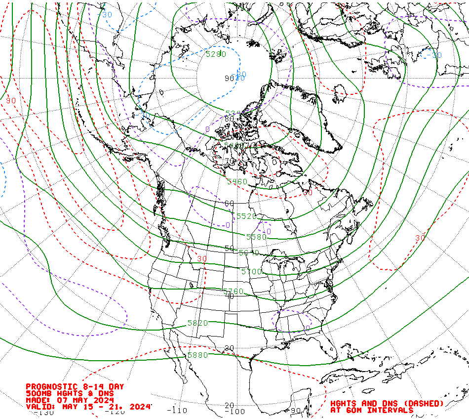
Just now, Addicks Fan 1981 said:
Not a trough to be seen here really, best NOAA chart we've had since June.
Haven't seen a NOAA 8-14 like that in 5 weeks
Decent apetite for change within today's runs amongst all of the models
looked like all was lost on Friday for the foreseeable. Will we get the day 10 push back on tommorows runs or will the HP come into day 8/9?
-
2
-
-
Another weekend in July another chart like this.
-
6
-
-
24 minutes ago, Snowyowl9 said:
AH some straw clutching desperate if I m looking at 2 years ago..
What a mess whats happened to this summer,wheres the jet dived off to here..
Disregard my previous post
2021 was a stinker of a summer from the end of July until the end of August.
I thought it was a chart from July 2020.
The June of that year was exceptional in NW England.
Not so much for the south
.png.71270075f455a5f397f8ce9404aa2683.png)
.png.f07bf7fecca161ceecca0fd53082c510.png)


.png.cdf7fb715269ef4ebf226c626a660407.png)


Model Output Discussion - Mid Summer Onwards
in Forecast Model Discussion
Posted
Whenever I hear the words jungle music I cant help but think of this guy