


Rain All Night
-
Posts
1,354 -
Joined
-
Last visited
-
Days Won
1
Content Type
Forums
Blogs
Gallery
Events
Learn About Weather and Meteorology
Community guides
Posts posted by Rain All Night
-
-
On 11/05/2024 at 12:44, Rain All Night said:
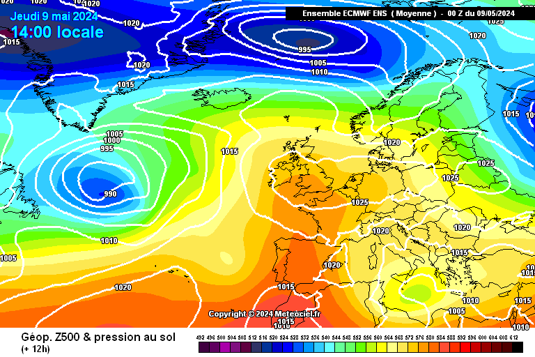
0z ensemble means, out to Sun 26 May (day 15)
The ECM ensemble seems to feature some more pleasant options for next weekend, and early the following week, than the other two. Beyond that, northwest/southeast split synoptics perhaps favoured. at the moment.

0z deterministic runs, on Sat 18 May (day 7)
Next Saturday looks OK, presumably some showers and an unwelcome wind direction for some. At least the worst of the weather will have been during the first half of the working week.
0z/6z ensemble means, out to bank holiday Mon 27 May (day 15)
I'm not sure what to make of next week yet. I get the impression there are a plurality of ensemble members showing troughing to our northwest.
0z/6z deterministic runs, on Sun 19 May (day 7)
Still think next weekend looks like it will be decent for many. Funny how the Icelandic low isn't there on the GFS.
-
 2
2
-
-
22 hours ago, Rain All Night said:
0z ensemble means, out to Sat 25 May (day 15)
ECM is currently the most optimistic for next weekend. Beyond that, both ECM and GFS still offer hope of raised heights with a southwesterly tilt, while the GEM goes off-script and offers a horror show.
0z deterministic runs, on Fri 17 May (day 7)
I hope it's looking closer to UKMO than the other two by this point next week.
0z ensemble means, out to Sun 26 May (day 15)
The ECM ensemble seems to feature some more pleasant options for next weekend, and early the following week, than the other two. Beyond that, northwest/southeast split synoptics perhaps favoured. at the moment.
0z deterministic runs, on Sat 18 May (day 7)
Next Saturday looks OK, presumably some showers and an unwelcome wind direction for some. At least the worst of the weather will have been during the first half of the working week.
-
4
-
 1
1
-
-
On 09/05/2024 at 11:49, Rain All Night said:
Hopefully everyone is quiet because you're all out enjoying the lovely weather we have now

0z ensemble means, out to Fri 24 May (day 15)
From Saturday 18th onwards, you can see the real potential for warmth to come up from the southwest, and you can also see the danger lurking up near Iceland. It's impossible to say any more than that at this stage, but the foundations for hope are certainly there.
0z deterministic runs, on Thu 16 May (day 7)
Hopefully from Thursday onwards, the slackening surface pressure will create more opportunities for dry and sunny interludes. So it oughtn't be the case that the whole working week needs to be considered ruined.
0z ensemble means, out to Sat 25 May (day 15)
ECM is currently the most optimistic for next weekend. Beyond that, both ECM and GFS still offer hope of raised heights with a southwesterly tilt, while the GEM goes off-script and offers a horror show.
0z deterministic runs, on Fri 17 May (day 7)
I hope it's looking closer to UKMO than the other two by this point next week.
-
On 08/05/2024 at 11:41, Rain All Night said:
0z ensemble means, out to Thu 23 May (day 15)
There remains no meaningful signal beyond Friday 17th May, so everything remains on the table for the following weekend.
0z deterministic runs, on Wed 15 May (day 7)
There's no denying it, this is unfortunate. At least we've got this week, including a fabulous-looking Friday and Saturday, and the hope that better days could return again from Saturday 18th May onwards.
Hopefully everyone is quiet because you're all out enjoying the lovely weather we have now
0z ensemble means, out to Fri 24 May (day 15)
From Saturday 18th onwards, you can see the real potential for warmth to come up from the southwest, and you can also see the danger lurking up near Iceland. It's impossible to say any more than that at this stage, but the foundations for hope are certainly there.
0z deterministic runs, on Thu 16 May (day 7)
Hopefully from Thursday onwards, the slackening surface pressure will create more opportunities for dry and sunny interludes. So it oughtn't be the case that the whole working week needs to be considered ruined.
-
5
-
-
21 hours ago, Rain All Night said:
0z ensemble means, out to Wed 22 May (day 15)
It seems the small trough is destined to fill over or just to the south of the UK next week, but the following weekend remains up for grabs.
0z deterministic runs, on Tue 14 May (day 7)
It seems the low is going underneath us to the southwest initially, which might buy some more time under the settled weather conditions for those further northeast?
I did find one dissenter...
0z ensemble means, out to Thu 23 May (day 15)
There remains no meaningful signal beyond Friday 17th May, so everything remains on the table for the following weekend.
0z deterministic runs, on Wed 15 May (day 7)
There's no denying it, this is unfortunate. At least we've got this week, including a fabulous-looking Friday and Saturday, and the hope that better days could return again from Saturday 18th May onwards.
-
3
-
-
On 06/05/2024 at 11:39, Rain All Night said:
0z ensemble means, out to Tue 21 May (day 15)
The ECM ensemble has by now established itself as the designated pessimist for the middle third of May.
This GEFS ensemble mean suggests to me that some member runs are offering some rather warm (if not entirely dry) conditions.
0z deterministic runs, on Mon 13 May (day 7)
An interesting selection. ECM really is keen to blow up an Atlantic trough. But UKMO offers an extension of settled and warm conditions for many as the next working week begins.
0z ensemble means, out to Wed 22 May (day 15)
It seems the small trough is destined to fill over or just to the south of the UK next week, but the following weekend remains up for grabs.
0z deterministic runs, on Tue 14 May (day 7)
It seems the low is going underneath us to the southwest initially, which might buy some more time under the settled weather conditions for those further northeast?
I did find one dissenter...
-
2
-
-
23 hours ago, Rain All Night said:
0z ensemble means, out to Mon 20 May (day 15)
ECM has dropped its aggressive Atlantic troughing solutions of yesterday morning and has moved towards to the GEFS, which shows a shallow trough transferring from the Atlantic to the south of the UK for the week beginning Mon 13th May. This will presumably bring some unsettled conditions to my vicinity.
Beyond mid-May, though the means are heavily blurred, a couple of themes consistent between the models are the jet stream preferring a southerly track, and Atlantic high expansion remaining on the table.
0z deterministic runs, on Sun 12 May (day 7)
The settled regime looks as though it should survive through to the end of next weekend, with the chances of this appearing greater towards the southeast.
0z ensemble means, out to Tue 21 May (day 15)
The ECM ensemble has by now established itself as the designated pessimist for the middle third of May.
This GEFS ensemble mean suggests to me that some member runs are offering some rather warm (if not entirely dry) conditions.
0z deterministic runs, on Mon 13 May (day 7)
An interesting selection. ECM really is keen to blow up an Atlantic trough. But UKMO offers an extension of settled and warm conditions for many as the next working week begins.
-
2
-
-
On 04/05/2024 at 11:17, Rain All Night said:
0z ensemble means, out to Sun 19 May (day 15)
It's not good news this morning - the GEFS is similar to yesterday's runs with a shallow trough incoming, but the ECM is even more aggressive about shifting the jet stream way down south and introducing a vast Atlantic trough. Enjoy this coming week or so while it lasts.
0z deterministic runs, on Sat 11 May (day 7) - for all your Eurovision Song Contest parties
GFS op wants to carry on the party with continued anticyclonic activity well beyond the frame shown here.
0z ensemble means, out to Mon 20 May (day 15)
ECM has dropped its aggressive Atlantic troughing solutions of yesterday morning and has moved towards to the GEFS, which shows a shallow trough transferring from the Atlantic to the south of the UK for the week beginning Mon 13th May. This will presumably bring some unsettled conditions to my vicinity.
Beyond mid-May, though the means are heavily blurred, a couple of themes consistent between the models are the jet stream preferring a southerly track, and Atlantic high expansion remaining on the table.
0z deterministic runs, on Sun 12 May (day 7)
The settled regime looks as though it should survive through to the end of next weekend, with the chances of this appearing greater towards the southeast.
-
3
-
1
-
-
Scorcher The clusters suggest there weren't many more settled scenarios in that ensemble run.
We are fortunate that the two GEFS runs this morning weren't as negative as the ECM and that the worst period was beyond day 10, so we can hope for a flip. We can also still have nice days under poor synoptics at this time of year with the strong sun, so that helps.
-
4
-
-
2 hours ago, Rain All Night said:
0z ensemble means, out to Sun 19 May (day 15)
0z deterministic runs, on Sat 11 May (day 7) - for all your Eurovision Song Contest parties
GFS op wants to carry on the party with continued anticyclonic activity well beyond the frame shown here.
I just noticed that I forgot to insert my commentary on the ensemble means. It's not good news - the GEFS is similar to yesterday's runs with a shallow trough incoming, but the ECM is even more aggressive about shifting the jet stream way down south and introducing a vast Atlantic trough. Enjoy this coming week or so while it lasts.
-
1
-
-
22 hours ago, Rain All Night said:
0z ensemble means, out to Sat 18 May (day 15)
It looks likely that the new Atlantic trough will have pushed our high away by around the 13th/14th, by which point we may have had around five days of fairly settled weather nationwide (depending on specifics of the surface high), including a weekend.
Beyond that there are signals both for Atlantic ridging, and for shallow troughing to our immediate west.
The former signal for direct retrogression of our high into the Atlantic with cold trough formation to our east is gone now.
0z deterministic runs, on Fri 10 May (day 7)
There's that new Atlantic trough in development, while we are under the influence of the high, which is looking a bit squashed.
0z ensemble means, out to Sun 19 May (day 15)
0z deterministic runs, on Sat 11 May (day 7) - for all your Eurovision Song Contest parties
GFS op wants to carry on the party with continued anticyclonic activity well beyond the frame shown here.
-
2
-
 1
1
-
-
On 02/05/2024 at 12:36, Rain All Night said:
0z ensemble means, out to Fri 17 May (day 15)
The high looks as though it could stay in place over the UK throughout next weekend, which would be a real blessing. After that, the means blur out any clear signal, but the high perhaps now looks more likely to sink than to retrogress.
0z deterministic runs, on Thu 9 May (day 7)
9th May is the one day that has been producing eye-catching ensemble mean charts for ages... will it now deliver?
0z ensemble means, out to Sat 18 May (day 15)
It looks likely that the new Atlantic trough will have pushed our high away by around the 13th/14th, by which point we may have had around five days of fairly settled weather nationwide (depending on specifics of the surface high), including a weekend.
Beyond that there are signals both for Atlantic ridging, and for shallow troughing to our immediate west.
The former signal for direct retrogression of our high into the Atlantic with cold trough formation to our east is gone now.
0z deterministic runs, on Fri 10 May (day 7)
There's that new Atlantic trough in development, while we are under the influence of the high, which is looking a bit squashed.
-
3
-
-
This just about qualifies as model output as it's the T+0h analysis from the hourly GFS... the view over Europe is quite striking today, both at the surface and at 850hPa:
Colours = temperature, white lines = wind
https://earth.nullschool.net/#current/wind/isobaric/850hPa/overlay=temp/orthographic=0.00,55.00,2077
-
2
-
-
17 hours ago, Rain All Night said:
0z ensemble means, out to Thu 16 May (day 15)
There seem to be more ensemble members than before featuring Atlantic lows riding in over the top of the high, especially from 12th May onwards. The signal for the high to move west into the Atlantic seems weaker now than a few days back.
0z deterministic runs, on Wed 8 May (day 7)
UKMO and ICON show little lows getting in the way of the ridge pushing up from the south, which is an outcome that seems to have been averaged away in the ensemble means presented above.
0z ensemble means, out to Fri 17 May (day 15)
The high looks as though it could stay in place over the UK throughout next weekend, which would be a real blessing. After that, the means blur out any clear signal, but the high perhaps now looks more likely to sink than to retrogress.
0z deterministic runs, on Thu 9 May (day 7)
9th May is the one day that has been producing eye-catching ensemble mean charts for ages... will it now deliver?
-
9
-
-
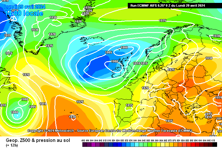
On 29/04/2024 at 12:10, Rain All Night said:
0z deterministic runs, out to Mon 6 May (day 7) - bank holiday Monday
Warmer air arrives from Thursday, and then I can't call what happens over the weekend - it won't be ECM's previously-suggested anticyclone, but there are some options here that aren't too bad, particularly UKMO.
0z ensemble means, out to Tue 14 May (day 15)
ECM 9th May
 - only shame is it's not a Saturday!
The high still seems to retrogress slowly from then on...
0z ensemble means, out to Thu 16 May (day 15)
There seem to be more ensemble members than before featuring Atlantic lows riding in over the top of the high, especially from 12th May onwards. The signal for the high to move west into the Atlantic seems weaker now than a few days back.
0z deterministic runs, on Wed 8 May (day 7)
UKMO and ICON show little lows getting in the way of the ridge pushing up from the south, which is an outcome that seems to have been averaged away in the ensemble means presented above.
Original post: https://community.netweather.tv/topic/99814-model-output-discussion-spring-has-sprung/?do=findComment&comment=5063597 -
On 29/04/2024 at 12:10, Rain All Night said:
0z deterministic runs, out to Mon 6 May (day 7) - bank holiday Monday
Warmer air arrives from Thursday, and then I can't call what happens over the weekend - it won't be ECM's previously-suggested anticyclone, but there are some options here that aren't too bad, particularly UKMO.
0z ensemble means, out to Tue 14 May (day 15)
ECM 9th May
- only shame is it's not a Saturday!
The high still seems to retrogress slowly from then on...
0z ensemble means, out to Thu 16 May (day 15)
There seem to be more ensemble members than before featuring Atlantic lows riding in over the top of the high, especially from 12th May onwards. The signal for the high to move west into the Atlantic seems weaker now than a few days back.
0z deterministic runs, on Wed 8 May (day 7)
UKMO and ICON show little lows getting in the way of the ridge pushing up from the south, which is an outcome that seems to have been averaged away in the ensemble means presented above.
-
2
-
3
-
-
12 hours ago, Rain All Night said:
0z deterministic runs, out to Mon 6 May (day 7) - bank holiday Monday
Warmer air arrives from Thursday, and then I can't call what happens over the weekend - it won't be ECM's previously-suggested anticyclone, but there are some options here that aren't too bad, particularly UKMO.
0z ensemble means, out to Tue 14 May (day 15)
ECM 9th May
- only shame is it's not a Saturday!
The high still seems to retrogress slowly from then on...
-
7
-
-
11 hours ago, Rain All Night said:
0z deterministic runs, out to Sun 5 May (day 7) - bank holiday Sunday
Discordance at day 7: GFS and AIFS are showing us what I meant previously about there being plenty of ways for the bank holiday weekend to go wrong, but the regular ECM shows us how it could go just right.
0z ensemble means, out to Mon 13 May (day 15)
Each ensemble prefers the take of its own deterministic run on how we will fare over the bank holiday weekend.
They start to agree again around 9th May on a resurgence of high pressure from the south, though it appears this could be followed once again by retrogression of high pressure into the Atlantic and another cold trough setting up to our east towards mid-May.
12z deterministic runs, out to Sun 5 May (day 7) - bank holiday Sunday
It's OK, ICON is the only model that matters
 #atleastitwillbemild
12z ensemble means, out to Mon 13 May (day 15)
GEFS perhaps not quite as keen as ECM to send the high packing over the Atlantic towards mid-May?
-
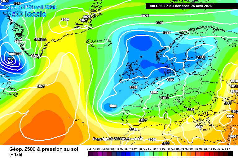
20 hours ago, Rain All Night said:
0z deterministic runs, out to Sat 4 May (day 7) - bank holiday Saturday
Possible brief warmth on the bank holiday weekend, but plenty of ways for it to go wrong?
0z/6z ensemble means, out to Sun 12 May (day 15)
Perhaps some anticyclonic activity over the UK around 9th May? Otherwise, not much to report.
0z deterministic runs, out to Sun 5 May (day 7) - bank holiday Sunday
Discordance at day 7: GFS and AIFS are showing us what I meant previously about there being plenty of ways for the bank holiday weekend to go wrong, but the regular ECM shows us how it could go just right.
0z ensemble means, out to Mon 13 May (day 15)
Each ensemble prefers the take of its own deterministic run on how we will fare over the bank holiday weekend.
They start to agree again around 9th May on a resurgence of high pressure from the south, though it appears this could be followed once again by retrogression of high pressure into the Atlantic and another cold trough setting up to our east towards mid-May.
-
3
-
-
On 26/04/2024 at 15:05, Rain All Night said:
0z deterministic runs, out to Fri 3 May (day 7)
I'll take the developments from 1st May onwards without complaint - from the Met Office app forecast, it looks as though even down here in the far south we will see improved temperatures along with the inevitable showers. Should be nice for those further north who may stay dry?
0z ensemble means, out to Sat 11 May (day 15)
Through the first five days of May, we will see upper-level high pressure retrogress gracefully through the UK, teasing us with warmer air before leaving us once again at the mercy of cooler pressure patterns, which currently seem to be favoured by the ensembles right through the first third of May.
0z deterministic runs, out to Sat 4 May (day 7) - bank holiday Saturday
Possible brief warmth on the bank holiday weekend, but plenty of ways for it to go wrong?
0z/6z ensemble means, out to Sun 12 May (day 15)
Perhaps some anticyclonic activity over the UK around 9th May? Otherwise, not much to report.
-
On 25/04/2024 at 12:10, Rain All Night said:
0z deterministic runs, out to Thu 2 May (day 7)
Start of May doesn't look too bad for the northeast and Scotland then?
0z ensemble means, out to Fri 10 May (day 15)
GEFS still doesn't want that easterly! Later on it's still just the same story of Atlantic ridging with us looking to be on the cold side of it.
0z deterministic runs, out to Fri 3 May (day 7)
I'll take the developments from 1st May onwards without complaint - from the Met Office app forecast, it looks as though even down here in the far south we will see improved temperatures along with the inevitable showers. Should be nice for those further north who may stay dry?
0z ensemble means, out to Sat 11 May (day 15)
Through the first five days of May, we will see upper-level high pressure retrogress gracefully through the UK, teasing us with warmer air before leaving us once again at the mercy of cooler pressure patterns, which currently seem to be favoured by the ensembles right through the first third of May.
-
1
-
1
-
-
18 hours ago, Rain All Night said:
0z deterministic runs, out to Wed 1 May (day 7)
Could we see that warmer easterly right at the beginning of May? Both flavours of ECM plus the UKMO seem to think it's possible...
0z ensemble means, out to Thu 9 May (day 15)
The ECM mean wants to support its op on the idea of warmer air coming in briefly from the east right at the beginning of May. Beyond that we have clear signs of anticyclonic activity in our vicinity in early May, but with an equally clear risk that this will remain too far to our west or southwest for us to warm up.
Why did it feel so darn cold when I woke up this morning?!
Current temperature (colours) and wind (lines) at 850hPa (left) and at the surface (right), screenshotted from https://earth.nullschool.net/ at something like 10am this morning.
0z deterministic runs, out to Thu 2 May (day 7)
Start of May doesn't look too bad for the northeast and Scotland then?
0z ensemble means, out to Fri 10 May (day 15)
GEFS still doesn't want that easterly! Later on it's still just the same story of Atlantic ridging with us looking to be on the cold side of it.
-
2
-
-
Ooh hello:
-
6
-
-
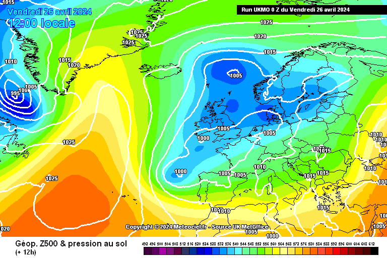
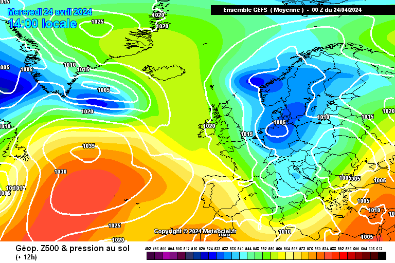
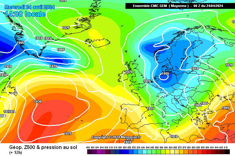
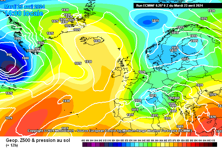
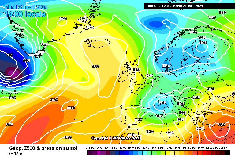
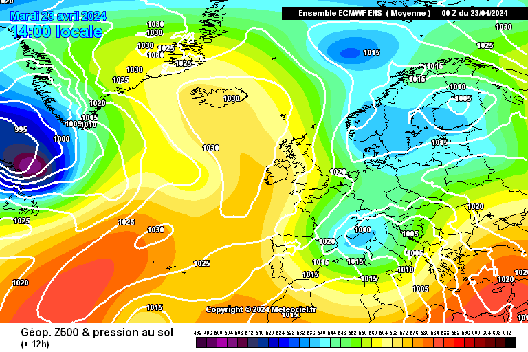
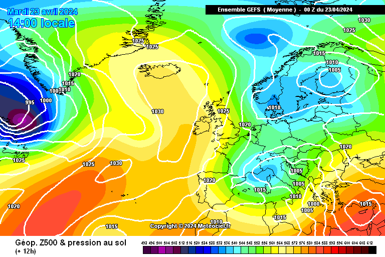
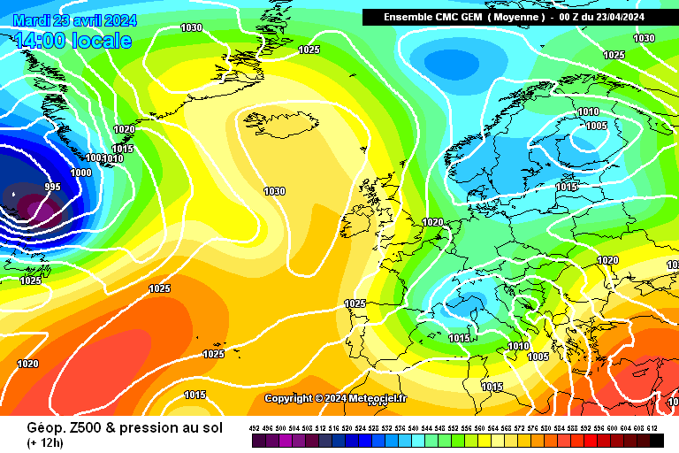
On 23/04/2024 at 12:48, Rain All Night said:
0z deterministic runs, out to Tue 30 Apr (day 7)
0z ensemble means, out to Wed 8 May (day 15)
It is as yet far from clear that the ridging activity that is evident from the Azores high in the first week of May is going to reach the shores of Britain... it currently seems that more ensemble members are going for it pushing up unhelpfully to our west instead...
We have now entered the four month period of the year with the best solar input... my frustration levels rapidly increase if we don't see favourable synoptic patterns during this precious time!
0z deterministic runs, out to Wed 1 May (day 7)
Could we see that warmer easterly right at the beginning of May? Both flavours of ECM plus the UKMO seem to think it's possible...
0z ensemble means, out to Thu 9 May (day 15)
The ECM mean wants to support its op on the idea of warmer air coming in briefly from the east right at the beginning of May. Beyond that we have clear signs of anticyclonic activity in our vicinity in early May, but with an equally clear risk that this will remain too far to our west or southwest for us to warm up.
Why did it feel so darn cold when I woke up this morning?!
Current temperature (colours) and wind (lines) at 850hPa (left) and at the surface (right), screenshotted from https://earth.nullschool.net/ at something like 10am this morning.
-
6
-
1
-


Model Output Discussion - Spring Has Sprung
in Forecast Model Discussion
Posted · Edited by Rain All Night
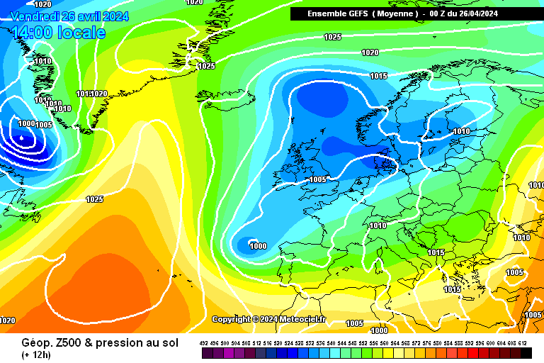
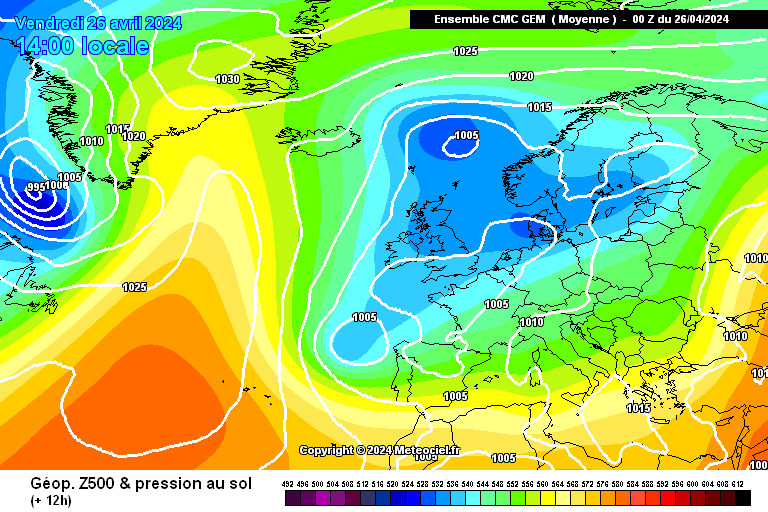
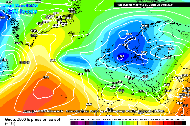
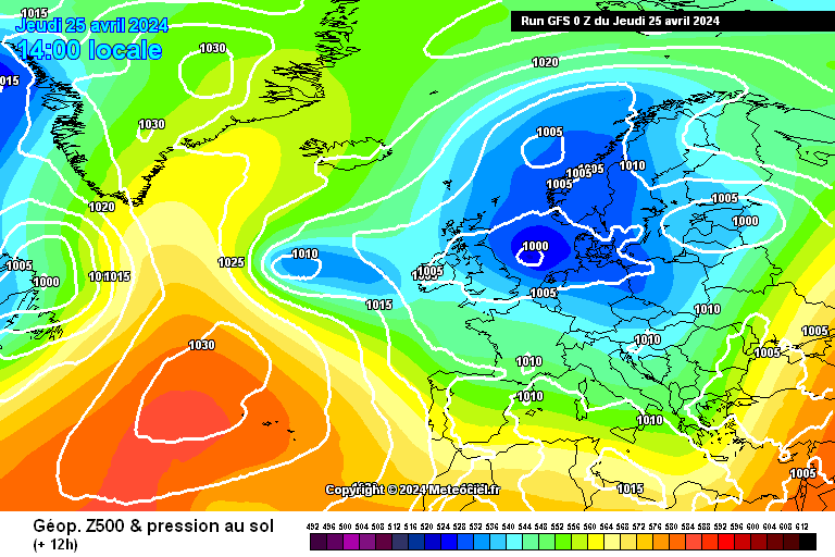
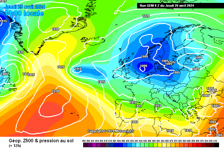
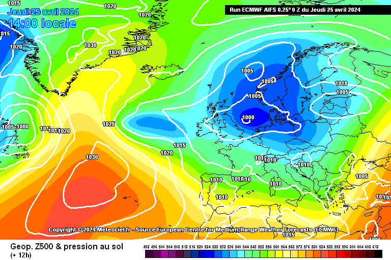
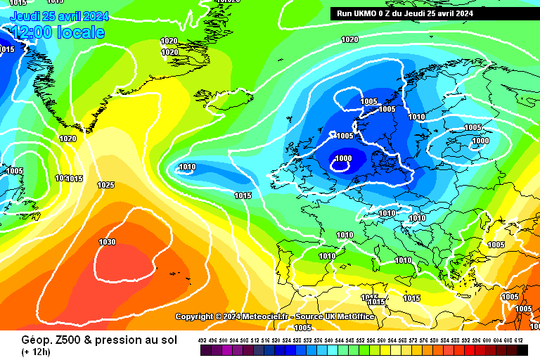
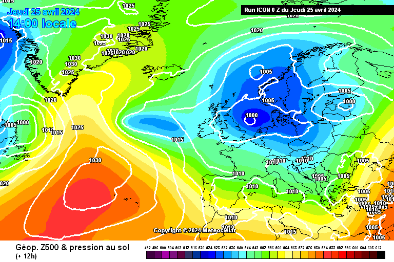
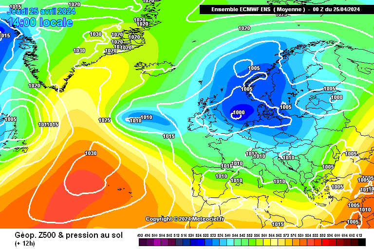
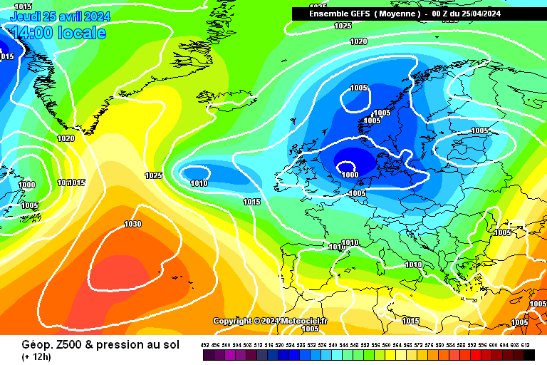
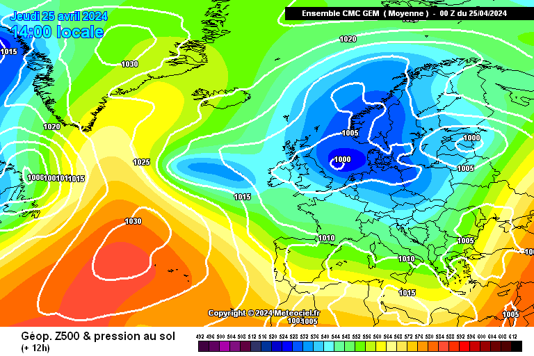
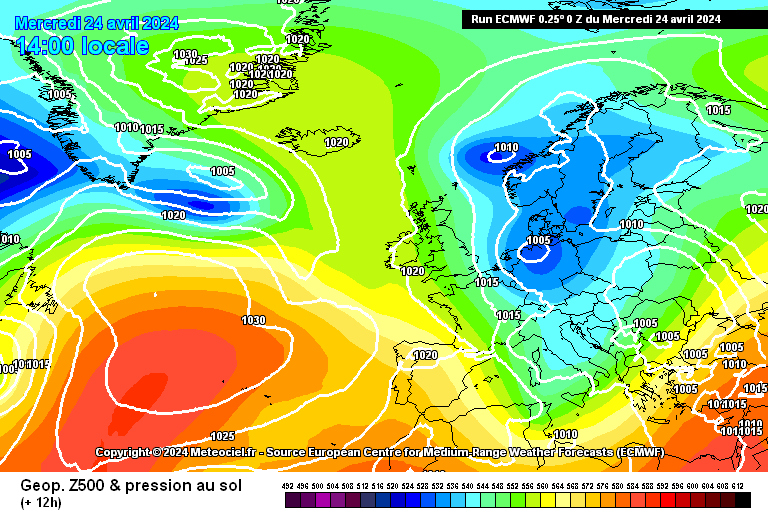
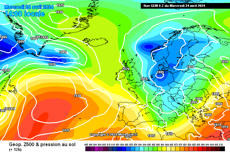
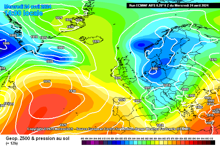
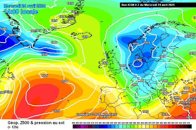
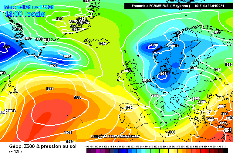
Next weekend still seems quite uncertain... not too keen on some of the solutions that are appearing... these are all day 6 charts...