


Ukwoody
-
Posts
318 -
Joined
-
Last visited
Content Type
Forums
Blogs
Gallery
Events
Learn About Weather and Meteorology
Community guides
Posts posted by Ukwoody
-
-
- Popular Post
- Popular Post
I see the nastiness to others hs started again. Just because you disagree with someone does not mean you be be snidey or nasty...
-
 12
12
-
 1
1
-
4 hours ago, EastAnglian said:
Soft hail showers here now temp falling still no snow though.

Soft hail is known as Graupel ;-)
-
Knocker. Could you expand on tonight's storm please. My thread is one of the quieter ones and almost certainly won't be covered in any detail. Always appreciate yours and John Holmes posts.
many thanks woody
-
Just taken dog out. Lets just say it was a brief walk in that wind and coldness.LOL
-
1
-
-
10 hours ago, Jen Beachcomber said:
Morning All from the Coast of Pembroke
I think the garden birds know it's getting colder today, just been out to feed them and already there's a 'munchfest' going on in the garden!!!
Had to smile today. Out at St Ishmaels and "walking" down the path were Mr and Mrs Blackbird. Even as a bird watcher I have never seen two birds SO puffed up in all my life. Like little fluffy balloons blown up against the wind, Lol.
-
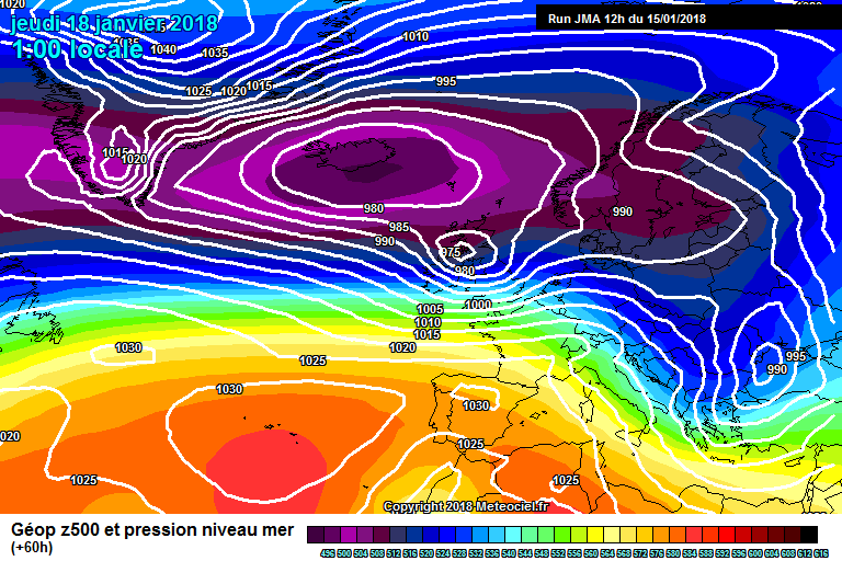
28 minutes ago, Mucka said:
Yes, I think one or two are being fooled by it not being modelled as closed system as it crosses the UK here and there. Winds to the South of the feature will be very stormy regardless unless it is pushed further South.
JMA's take on it
Sorry, what is a "closed system" and whats the difference?
-
1 december 2015 Paul said in relation to a question about tapatalk ... "I don't think so, not so much that it'll not be compatible but having looked into it before it's not something we've ever been too keen to opt in to. That said, a mobile app for the forum is on the agenda. ;-)
-
6 minutes ago, lindy2222 said:
I got told off for not behaving and being a wee bit sarcastic about the english.......im a nice wee scottish girl too.....
.... and I'm an Englishman proud to live in Wales, lol
-
2
-
-
Hi. You've been saying for a couple of years or so now that you are developing an App for the forums (rather then use Tapatalk). Just wondered if this is likely to happen anytime soon.
Woody
-
I get really cross with some on the Mod thread. I pass one sarky comment and it gets "reported" to Paul yet others can say whatever they want and get away with it all the time. Paul told me to use this thread!! I was going to leave this site as the way some poeple get treated on the Mod thread is appalling = however you're still stuck with me,LOL
-
2
-
-
5 hours ago, Clair_Witch said:
Those were the days! If only we could get a dumping like that again.
I wish!!
-
5 hours ago, johnholmes said:
Well shall we try and make some sense of how the models are treating things out to 72h and perhaps peeking out to 120h?
Below is the UK Met model output on Net Wx
https://www.netweather.tv/charts-and-data/met-office
We can use this and others I'll show to see how their model is dealing with the development/movement of the surface high and also at 500 mb, which is where the real work of forecasting occurs. Get that right and there is a good chance the surface will be near to what happens. Get it wrong then forget any prediction.
It does show the surface feature moving east, perhaps a shade NE comparing 00z with 12z yesterday. The upper trough, watch the 558 black line, has moved east and extended/sharpened somewhat, causing the surface ridge to be moved NE compared to the previous 12z issue. But remember this is partly sequential anyway, 12 hours further on, and to me it looks a reasonable prediction.
N
John, just want to say thanks for a sensible knowledgeable insight. Still a bit over my head but so much easier to understand then in the other thread - which I have stopped visiting due to the nastiness. Cheers!
-
2
-
-
Firstly, this is a so much better thread! I personally think T96 is better. My reasoning is by extending it to T120 you are really verging on the main model thread, and more worryingly is that by extending the time, leads to more uncertainty in understanding the models which leads the possibility of more arguments!
T96 is a good compromise for sensible friendly discussion and respectful disagreement
woody
-
1
-
-
5 minutes ago, mulzy said:
To be frank, most people come onto this forum in Winter to look for snow/wintry possibilities. Rain and gales, though interesting weather, doesn't really float most people's boats especially as this is the default here in the UK.
and half of the debate belongs in ramps and moans thread. The model discussions are often stab in the dark guessing at FI timescales by the uninitiated and if it doesn't include snow then it doesn't matter. That surely is NOT the main purpose of this thread when everything but snow gets ignored. This used to be a good thread for learning and open discussion about sensible charts etc, but nowadays it is mainly ramping.
-
6
-
-
I was predominatly referring to the low pressure system and gale force winds
-
2
-
-
On 19/12/2017 at 19:47, whiskers said:
Anybody knows what weather it is for xmas,it's a bit confusing in the model thread!
Yes, I get a bit cross with the model thread. some seem to just argue with almost any chart or more "expert" opinion and totally confuse the whole situation. Then others just costantly want to look two weeks ahead into FI when no-one really has a clue!
-
Why do some of you consistantly look so far into the future, guessing what will happen in F I? What about the shorter time span? Next week looks interesting yet is totally ignored in the haste to talk about possible snow and nothing else.
-
2
-
-
Hi all. I'm confused. In this mornings post by Paul, he suggests there may be a "storm" on Boxing day with strong winds. Yet toning some seem to be suggesting rather mild benign conditions. Have things changed? Certainly the charts around lunchtime seemed to suggest strong winds...
-
1
-
-
Good one, Cheers Blessed (and Welcome, lol)
-
1
-
-
1 hour ago, andymusic said:
anybody for a WHITE XMAS - gfs 12z looking good for one today
major storm on boxing day with blizzards in places
gfs gone a little nuts with a 965mb Hurricane over us boxing day onwards - but here's the thing - today's run means only about 5 days in milder air from next Monday before mr. freeze returns to pay us another visit
really looking like winter will behave more like winter this season
First time I've seen a chance of snow for Pembs!
-
Dry as a bone in Milford Haven and looks like zero chance of snow.
-
Nah, I think once again Milford Haven (and Tenby) will miss out on this event. :-(
-
to my untrained eye it seems as if us in the far west of wales (Milford Haven etc) will be missing out on these events?
-
3 minutes ago, Nick F said:
Agreement by the models to flatten out the upper flow over the N Atlantic and lengthen the wave lengths late weekend and early next week in response to deamplification of the upper trough over eastern N America, hence the shift of low heights eastwards from the tropospheric PV over Canada across Greenland and merging with low heights over Scandinavia.
However, recent operational runs and ensembles indicating re-amplification mid week of the trough over eastern N America, which teleconnects to amplification of a ridge over N Atlantic again later in the week. With potential for a Nly reload from the arctic.
Looking further ahead, EPS H5 mean suggesting ridging NE towards Scandinavia day 14?
Can someone translate this into Numpty talk for me please??? lol


Short range model discussion - into 2018
in Spring Weather Discussion
Posted
No far from it, but He does kindly post most days. So does John Holmes and a few others normally