


Dorsetbred
-
Posts
12,460 -
Joined
-
Last visited
-
Days Won
1
Content Type
Forums
Blogs
Gallery
Events
Learn About Weather and Meteorology
Community guides
Posts posted by Dorsetbred
-
-
Afternoon All, with temperature just hovering above single digits last night at 10.3°C at: 02:07, currently 17.4°C with RH80% and a 13mph breeze in from the SE. Some sunny spells but in the main it's patchy cloud

-
 1
1
-
-
12 minutes ago, Don said:
A winter month with a 10C+ CET?! I hope these words don't come back to haunt me in a few months!
Uncharted waters, so who knows what will transpire.. a point of note, the sea temperature in Bournemouth is 0.8C ABOVE the long term average currently..
-
Morning All, a clear morning a little Ac around to the N and looking cloudier to the west country on the sat image
Clear view out over the bay with some patchy Cu
Meanwhile overnight hit the single digits, nice....
Overnight low of 7.1°C at: 06:57 has climbed up to 17.5°C with RH74% and no breezse currently
Interesting to note the sea temperature is currently 0.8 °C above the long term average
Today's Bournemouth Pier sea temperature is 18.4 °C
(Statistics for 12 Sep 1981-2005 - mean: 16.4 °C max: 17.6 °C min: 15.0 °C)
-
 1
1
-
1
-
-
Well the sunny spells took a dive fairly quickly, now it's plain old Cu covering here whilst on the coast there are some breaks
Although the satellite image does suggest a thicker patch of cloud over us, which I certainly agree with.
Few clouds at a height of 3400 ft
Scattered clouds at a height of 4500 ft
Meanwhile todays top temp was 20.8°C at: 14:25 which has now dropped off a degree with RH64% with a very light 3mph breeze in from the SW
-
Morning All, a covering of Sc and some small Cu this morning, after an overnight low of 13.4°C at: 06:35, currently 16.7°C with RH78% and a 3mph breeze in from the N.
As noted on the this mornings TAF, cloud seems to be the order for the moment, and appears moe broken the further west you go
Few clouds at a height of 1600 ft
Broken clouds at a height of 3500 ft
The view across the bay is clear today..
-
Nice here, a westerly breeze sunny intervals and a peak of 19.8°C at: 14:03
How do neighbours hedges grow so damn much, mind you I do cut them back hard to force the growth their way!
-
1
-
-
The St is scurring eastwards after some patchy light rain earlier this mroning and patchy blue skies are appearing from the SW. Ovcernight low of 15.5°C at: 07:26 has made it up to 16.1°C with RH96%
Scattered clouds at a height of 700 ft
Broken clouds at a height of 3800 ftLooking at the satellite image, it seems today is looking a cloudy affair unless the cloud burns off
Looks like minimal chance of some rain here possibly until the end of next week, and the meagre 1.4mm we have received, hasn't even made the soil damp, so in to the garden to do some watering to help the end of season fruit and veggies swell..
-
1
-
-
40 minutes ago, Kiwi said:Funnel cloud or a weak tornado ?....not sure what the difference is.
Not a funnel, notice the within the rotation, how you can identify individual small vortices , which are spiralling around the main areaa of motion. Also notice how you can pick out the bigger motion later in nthe sequence as a small marea goes from left to right.
All the right signs , a pity it didn't have some more updraught (which could have been prevented by the houses breaking up the airflow)
Was it reported to TORRO?
The Tornado and Storm Research Organisation (TORRO)
WWW.TORRO.ORG.UKTORRO is a privately-supported research body specialising in severe convective weather in Britain and Ireland-
1
-
-
37 minutes ago, Rich_Clements said:
Some hefty short sharp showers here in Gloucester today, looking out of the office window to the pub garden on the opposite side of the road all of the drinkers have retreated under the umbrella's
Pwah, fair weather drinkers!
-
1
-
-
Morning All, a cloudy after some early morning measureable rainfall of 1mm after an overnight low of 15.2°C at: 03:25, it clawed it's way up to 16.9°C with RH93% and a very light breeze in fom the S at 4mph.
Satellite image shows the rain to be West and North of us
Confirmed by radar
And as confirmed on the TAF, a fairly low cloud ceiling
Broken clouds at a height of 500 ft
-
Thunder & heavy rain to the west of us this morning
Thunder & heavy rain to the east of us tonight
Thunder & heavy rain to the North of us tonight
Meanwhile in the middle we sit, with 16drops of rain and nothing else....Grr....
And currently 17.7°C outside with Current Indoor Temp. 26.7°C, another hot sweltering night ahead, could we have some strong breeze and clouds so I can get the temperature down...please...
Santa ..please take note, I'd like one of these for Christmas pleeze..
-
1
-
-
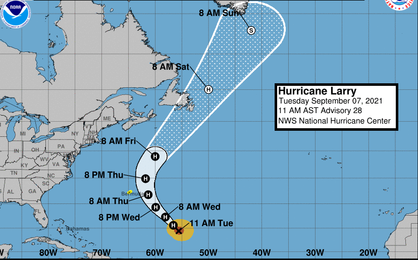
As Larry moves out of US it seems to be going to a party off the SE of Greenland as shown in the fax charts..
Which by late Sunday will have a major effect on the Jet stream and how it might affect the Uk with a long draw from the Artic area as the Jet appears to plunge southwards down the western side of the UK
-
2 hours ago, Alderc said:
I think I counted 7 drops of rain from that convective waste of time.
We got more than you in Poole, we got 16!
-
1
-
-
Well, I'm glad I picked today to paint the shed and ignored the forecasts, 16 drops of rain later, one half the shed done with two coats of wood paint. Tomorrow is hedge hacking time, as I'll ignore the forecast for tomorrow too. Maxed out at 26.6°C at: 12:37..
Beka, you'd be Ok in our house, it's still Current Indoor Temp. 27.6°C, and the windows are still open but the temperature isnt falling away..
-
1
-
-
Well, at least somebody in the area received some rain (even a little too much in a short time)
Thunderstorms cause flash-flooding in Devon
WWW.BBC.CO.UKBusinesses are affected and roads made impassable due to flood water caused by downpours. -
19 minutes ago, mike5900 said:
Cloudy starting to rain.
Same here, 16 drops later it stopped, doh
Spoiler -
Now that gap I was talking about has grown from earlier
And the edge of the cloud has yet to venture that much further
Back to the painting..
-
Phew after a very warm night with the overnight low of 15.3°C at: 06:50, currently 20.4°C with RH70%. Have all the dors and windows open to get some cool air in the house, currently indoors we have 27.3°C! The 11mph breeze in from the SE and cloudier conditions might help to ease that inside temperature, before I have to close everything down to keep the lurking male spiders away, having already found an amourous male of approx 6.5cms across hiding in the kitchen sink..
So how are we looking
....looks interesting to the SW
This sat image shows we are still only sitting on the sidelines
Meanwhile Blitortung looking good for a little later (maybe) but I do see a gap in that, and that'll be the gap that cruises right over us...
-
32 minutes ago, knocker said:
Moderate rain here now
Care to share?
-
19 minutes ago, Jo Farrow said:
HIgh pressure has dominated the UK weather over recent weeks and is feeding the current heat to the UK. A large Atlantic Hurricane is being watched by Bermuda and Newfoundland. Larry is making waves.
Jo.
Looking at the Jetstream chart, it shows the Jet consuming Ex Larry without that much of a ripple..
-
53 minutes ago, Lyn-M said:
These two days have been the warmest September days in my record here which goes back to 2000. Yesterday max was 29.8°C and today's 29.5°C, previous high September max was 28°C.
Always good to see the summer "residents" reaching new records...just think the winter folk coming out of hibernation, have missed all this fun..
-
1
-
-
22 minutes ago, knocker said:
Some quite interesting Ac encroaching this afternoon
This has been hovering out to the west for some hours now
That little "Finger" of cloud appears to be out over Lyme Bay from looking at the Sat image..
-
1
-
-
Nearly the same as yesterday temperature wise, with 27.4°C at: 13:08 as the peak. Light breeze is just knocking the top off the temperatures, a few hours in the New Forest & Lyndhurst, very pleasant..
BUT where did all that traffic come from , the end of the M27 was tailing back on to the Mway, and the A35 at Ringwood was solid right back up beyind Poulner Hill. 20mins queue to get in to Lyndhurst?
Haven't people got work to do, so many caravans on the move into the area.
R & R finishes for me this week, back to work next week, enjoying the sunshine whilst I can..
-
1
-
-
Morning All, after an overnight low of 12.9°C at: 06:33, it's climbing nicely, so far up to 22.3°C with RH72%.
The satellite image shows just how clear England is today, apart from the border oop north, norra cloud to be seen..
The sea mist has also lifted, as Old Harry comes back in to view
-
1
-


South West and Central Southern England Regional Weather Discussion 08 Feb 2021 Onward
in Regional
Posted · Edited by Dorsetbred
Oh I would think as soon as people begin reading the Strat & Polar Vortex thread (which is currently in throat slitting mode)
OR
take time to read,
OR
have read the "Have you turned your heating on yet thread.."
Damn, now I've gone and done it, the winter crew will soon be along now..