


weather eater
-
Posts
2,185 -
Joined
-
Last visited
-
Days Won
4
Content Type
Forums
Blogs
Gallery
Events
Learn About Weather and Meteorology
Community guides
Posts posted by weather eater
-
-
Well a transient ridge on the ECM and then pretty flat, gone is this morning plan it always looked likely to be the case.
-
From the Beeb
Virgin Trains said in a later tweet: "We are advising all customers not to attempt to travel. Customers already on services will be taken to the nearest station."
It also said all services out of London Euston were suspended until further notice due to adverse weather.
And
The M60 Barton High Level Bridge in Greater Manchester is closed in both directions. A lorry has overturned on to a car.
-
 1
1
-
-
The wind is kicking up something fierce here now. Just had two wheely bins chasing each other down the road. I don't think I can ever remember a red warning for NW England for wind before.
Looking at GFS ensembles there is still virtually no support for an ECM/GEM 00z type Easterly forming and even though I wouldn't read too much into that yet I am already getting the feeling we are flogging a dead horse. reverse jinx
My yes massive gust here a few minutes ago, telephone lines just outside are making some weird noises and the conservatory is creaking like a ship in a gale. As for the models it just doesn’t feel like they are going to do more than tease us a little more before winter bows out.
-
1
-
-
Yes the UKMO is not up to much however I still don't rate it at 144hrs anyway. The GFS on the other hand wouldn't have to change much, its certainly got plenty of upgrade potential, besides I prefer a slow evolution, I don't trust wonder charts a 120hrs plus anyway. My word its got windy here in just the last 15 mins.
-
1
-
-
Love this tweet
Danny Savage North of England Correspondent, BBC Newstweets: It is getting car door breakingly breezy. Turning vehicles into the wind before we get out. Otherwise hinges make horrible noise.
-
A months worth of rain during the next few days is a frightening prospect on top of all the current severe flooding, but that's what the models are showing.

And as its quiet I just picked this up from the BBC
A disturbing picture of flooded Britain is revealed in new figures about the saturation of the ground. The British Geological Survey runs 32 boreholes across the country and an astonishing nine of them show record water levels. One has never been so full in its 179 years of operation.
The scientists analysing the data describe it as extraordinary. And these high levels are not just of scientific interest. They mean that the ground is at full capacity, so any more rain inevitably means more flooding. Readings from the rivers are equally alarming. Of 65 river sampling stations, 17 have never seen such high average flows for January. And the worrying development is that these exceptional flows have lasted so long and are likely to continue.
The last thing anyone needs now is more rain but that's exactly what's forecast. As one scientist at the Centre for Ecology and Hydrology put it: "There's literally nowhere for more water to go - the ground is full." That can only worsen the great pulses of floodwater now heading downstream. Most floods are short and severe; this one is in a long-lasting and hazardous league of its own.
-
8
-
-
Yes the 06z fails to back up the ECM but I'm far more interested in the 12z and the UKMO, will they back this morning’s ECM, will this evenings ECM show some continuity with the earlier output. Meanwhile I see the METO have issued some red warnings for parts of the coast of Wales and NW England, it’s certainly gusty here now that the front has gone through. Got distracted doing this post by a Game of thrones season 4 trailer, looking forward to that.
-
Yes must admit over the years my biased towards cold has always affected my judgement of the model output although in recent times I have moderated this.
One concerning aspect if a bitter E,ly should occur is ice especially if the floods do not drain away in time. Shame I cannot play Ice hockey anymore otherwise I could of played a match on the River Nene here.
Still a big freeze up now and the Fenland ice skaters will have a chance on all those flooded fields, they don't get many chances but they were always on About Anglia when I was in my childhood and youth in the 60s and 70s.
-
1
-
-
No model output is infallible. This is why it is wise to use forecasting instinct alongside computers when looking at the medium/long range.
Indeed Dave but by the same token forecasters are not infallible either, that’s been shown on this forum many times over the years by people allowing their hearts to rule their heads and it applies to those with lots of knowledge and to those with a much more modest amount, I include myself in that. When it comes to forecasting in the mid to longer range, a wise head is a sceptical head, I’ll start clapping when the fat lady is in the auditorium and about to come on stage.
-
6
-
-
Well it’s a case of stick or twist with the ridge this morning. Any cold lover myself included will love the ECM, but how will change and evolve over the coming days, can it change for the better or is it just another red herring. Personally I doubt the ECM when it comes to easterlies, but if I’m wrong I will still enjoy my humble pie. Best case scenario the ECM is close, Second best, we get some sort of dryer interlude. The worst case, something like the GFS, which although not bad snow wise for some at times, will just heap more misery on the flooded south.
-
3
-
-
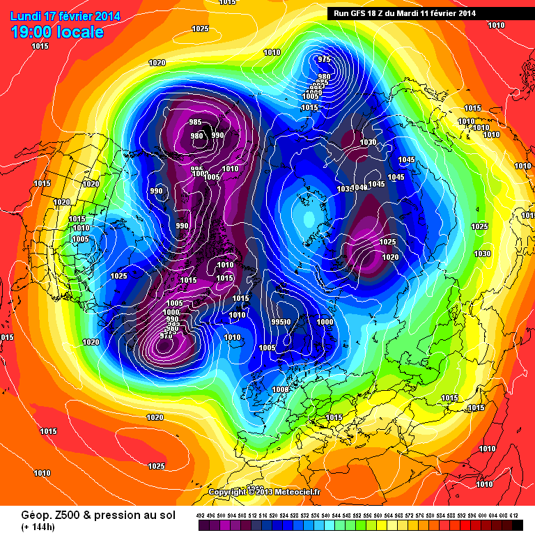
The GFS fanboys should look over the last 24 hours- as that's how long its taken the model to catch the UKMO & JMA / ECM up tonight--
now at 144-
http://modeles.meteociel.fr/modeles/gfs/runs/2014021118/gfsnh-0-144.png?18
NB Ive included the ECM above- because its had the ridge, however its been fast to break it down.
All models close at 120, thereafter differing solutions in terms of how far & how fast east the atlantic progresses. The Grojean (GEM) model being the slowest....
Pretty much last chance saloon for Winter....
GFS fanboys ???? a bit like telling a work colleague you like a couple of songs by a band only to find the next day he’s been telling everyone you are some kind of massive groupie. But I digress, the fact of the matter is that the GFS has only caught up with the ECM/UKMO if the output remains the same and a ridge develops. At the moment all we have are projections at 144hrs that will evolve and change and trust me Steve I would love you to be right and would gladly eat the humble pie if we finally get something to shout about this winter...
-
3
-
-
I think the GEM solution can probably be kicked out as its been useless at that range this winter, the JMA looks more plausible, the GEFS has been criticized for the central USA by NCEP so I'd give those a wide berth. The ECM operational run moves a chunk of low heights across Norway this suppresses the small ridge to the north and isn't supported by any of the other operationals at the T120 to T144hr range.The UKMO is similar to the JMA, I think that combo is the more likely outcome.
It could be Nick, I guess the story of the winter so far has been no matter what we think may happen or whatever the models have shown from time to time the Atlantic just steams back in, I just have a hunch that it’s going to do it to us again and desperately hope I’m wrong. Like it, loathe, find it interesting or not, this winter has been extraordinary, I can’t remember anything like it.
-
3
-
-
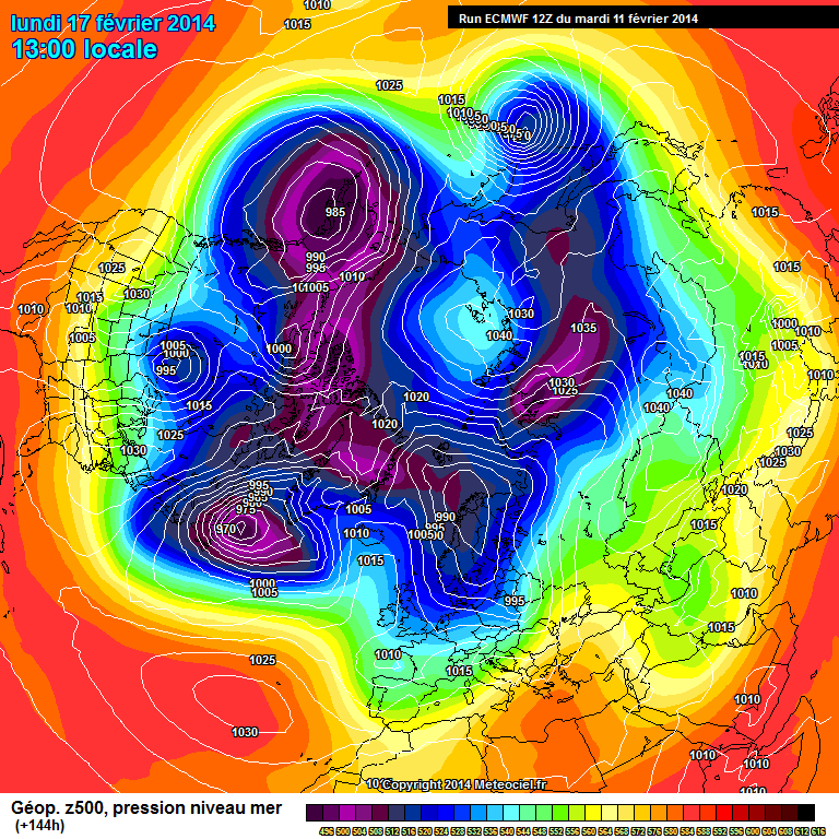
That's a bizarre transition from T120 to T144hrs, I think the ECM may have lost the plot there and goes into my SSO(suspicious synoptic outcome) column as unlikely to verify as shown.
Fishy indeed and it is flat as a pancake in its latter stages, I feel I'm dreaming has it well summed up "slacker zonal flow with intermittent ridging." and while it may get me more flak I suspect the GFS is not far of the mark. The GEM is great but I'd bet my house it won't happen, the UKMO shapes up well but its 144hr output never fills me with confidence.
-
1
-
-
http://www.meteociel.fr/modeles/ecmwf/runs/2014021112/ECH1-144.GIF?11-0
that's as bad as the 120 was good....
Sums up this winter, blink and the darn thing has refused the first hurdle.
-
i think the GEM is trying to demonstrate the potential you mention steve-
what could happen if your potential came to fruition. with a little slider thrown in for good measure!
Yes the GEM is turning into just the kind of thing we want to see, indeed what we have been looking for all winter, a bit of a diamond in fact or Sapphire with all that blue, I just wish I had some faith in it, but I don't.
-
2
-
-
Well a bit of a lifeline thrown out by the UKMO, potential yes, another red herring maybe. The GFS pretty much sticking to its guns, the storm for Saturday has been upgraded, (not a word I want to be using for anything but Cold and snow in winter but there you have it) thereafter as you were, with some easing of the intensity of wind and rain coming our way. Unfortunately towards the end of the run the PV is back big time and with HP over Europe the phrase mild SWlys spring to mind.
-
We have certainly seen some snow today, quite heavy for a while, even down to lower levels, I can't say I've really enjoyed it though, as all it has done is just added to the local swamp conditions, looks pretty on the hill tops I guess.
-
1
-
-
Just seen the BBC forecast and some reasonable cheer for some of us who are looking for a drop of the white stuff, a possibility of snow later today across parts of the midlands and up into EA, we have a rain snow mix here at the moment, mainly snow. Tomorrow very strong winds especially for the midlands north, very heavy rain for all parts followed by the prospects of what looks Blizzard conditions for parts of the North by tomorrow evening.
-
2
-
-
The myth being that the ECM flip flopped on it. All the models dealt with the onset of the 2010 freeze like clockwork.Anyway, a more realistic take on the possible undercutting, given the upstream profile from the 00z runs.
Looking at the archives, it is better than I thought although some runs appear to be missing, so maybe flip flopping is a phrase too far, although it does not alter the fact that the GFS was very good with its modelling of that spell. It also doesn’t alter the point I was actually making, which was that despite the ECMs better verification stats it is foolish to dismiss the GFS on every occasion as the GFS does better than the ECM some of the time. An open mind is always a useful tool provided it’s not so open that your brains dribble out of your ears and as I have said many times I do not rate the GFS over the ECM. In my view the best thing the could happen with the GFS is a dropping of the 06z and 18z runs as IMO they make the GFS look poorer than it actually is.
-
Here's my post from yesterday for the period following the wind and rain of this week.
"My punt would be for still a relatively flat pattern but much less intense in terms of wind and rain than the last couple of weeks, I would not expect the GFS 12z to be a million miles out from the general pattern at 200hrs."
I pretty much think the model suites this morning reflect that this is still a reasonable call.
-
1
-
-
Chaps lets move on please from this debate it happens every year. Rather than debate tirelessly why not research it like Steve has done lots of times. Figures don't lie.
Let's discuss the potential weather coming up and keep this ongoing debate for another thread .
Except there is no debate did I not say the ECM out performs the GFS, have I not said it before, the only point I was making is that it is a mistake to dismiss the GFS over the ECM on every occasion, the weather makes fools of both the models and the knowledgeable it has done so many time over the years on this forum, GPs its coming post from last year a case in point.
-
4
-
-
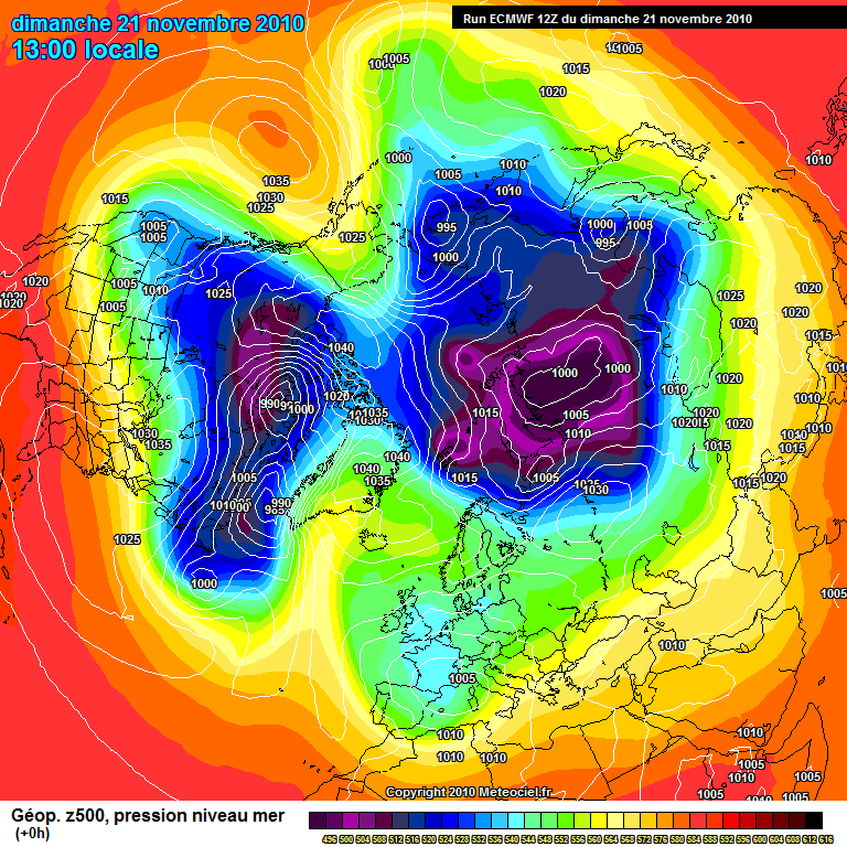
I will concede that the GFS outcomes have been better this year- but it takes a record +AO for the GFS to verify....
I just wish you would populate your posts with facts-
21st November 2010- is the day it started ( start of the Greenland high)
http://www.meteociel.fr/modeles/ecmwf/archives/2010112112/ECH1-0.GIF?12
ECM at 192 8 days before
http://www.meteociel.fr/modeles/ecmwf/archives/2010111312/ECH1-192.GIF?12 perfect WAA over Greenland & then 168 the next day-
http://www.meteociel.fr/modeles/ecmwf/archives/2010111412/ECH1-168.GIF?12 Brilliant accuracy
GFS 192 8 days before
http://modeles.meteociel.fr/modeles/gfs/archives/gfsnh-2010111306-0-192.png?6 a bit flat but in the ball park
http://modeles.meteociel.fr/modeles/gfs/archives/gfsnh-2010111406-0-168.png?6 Much better
So you would say the ECM was more accurate 9/10 GFS 8/10
If your going to cite specific times then at least get the facts correct.
But, going to the first paragraph- the ECM has gone from my 10/10 model this winter with minimal silly errors to just 8/10 with many blocking errors with the GFS about 6/10 - UKMO 7.5/10- JMA 7/10
All it means is where as before we could put confidence in the ECM at 168 with some foundation, now we don't have 1 model that we can really place our trust in- however because it does verify number 1 we always have to review the ECM first.
If it was formula 1 drivers the differences are I would say
ECM Vettel ( BOOOO)
UKMO Hamilton
JMA Alonso
GFS webber - sometimes has his day but most of the time off the pace in forth......
The GEM is like Grojean.....
S
Not bad and here's the GFS for the 21st November, 12z on the on the 10th Nov, the GFS picked it up earlier and was more consistent, I would say for 11 days out pretty good. I would recommend looking at the archives for the GFS 12z run for 11th 12th and 13th Nov 2010, all pretty good given the range, some myth BA
-
1
-
-
GFS
GFS trumped ECM.... lolol-
ECM has tarnished its reputation this winter with creating blocking scenarios at the outer reaches of FI- Ie Day 9 & 10- sometimes even at day 7/8.
However when you remember the run up to the last missed cold spell the GFS was MILES & MILES away from the correct solution where as the Euros trumped the GFS.
1nd of Jan 168
GFS has the store into the Northern Atlantic
ECM
http://www.meteociel.fr/modeles/ecmwf/archives/2014010100/ECH1-168.GIF?00
Massive inland runner - storm over Canada...
Actual outcome
http://modeles.meteociel.fr/modeles/gfs/archives/gfsnh-2014010800-0-6.png
ECM SPOT ON for days. GFS miles away.
infact if you open the actual outcome & the ECM 168 you would think its the same chart.
Theres always selective memory when it comes to the GFS - also perhaps because it runs 4 a day is does actually get the right outcome.
However the GFS did perform better than the fail before Christmas-
Statistically for the NH the ECM is tops-
http://www.emc.ncep.noaa.gov/gmb/STATS/html/new_acz6.html
GFS forth - so really your faith in the GFS is misplaced....
F./F/S
I don't know why I bother on here.
the problem this winter is that ALL the fantastic day 10 charts or even day 6 charts for failed to deliver FOR THE UK, for others though they did deliver as per ECM, like the other day with 40cm of snow over in Denmark etc.
Nothing selective about it, I'm sure if you look across the whole winter you would find that the GFS has performed pretty well and been better at times than the ECM, the last couple of weeks for a start off. Besides its blocking patterns the ECM seems to want to overdo and it’s not just been his year either. Remember 2010 the GFS picked it up that memorable spell way before the ECM, the ECM flapped about all over the place. We all know the ECM out performs the GFS in the verification stats globally I certainly would not dream of saying otherwise, but it’s not a case of, always out performs it in every scenario and if we lull ourselves into the idea that it does, then we end up with a blinkered view. Personally I don’t buy into the either or method of thinking that seems to pervade society, so in terms of models it’s not either the GFS or the ECM it’s more a case of which one has performed best in our back yard at any given time, granted its more likely to be the ECM but not to such a degree that the GFS should always be discounted.
-
3
-
-
Well in the here and now or at least nowish, the song remains the same wind, rain and the continuation of the sinking of the south. As for the ECM, well wonderful if it happens but I have no faith in ECM mid range blocking projections, I said it in December and I’ve seen nothing to change my mind. I have to say whatever the verification stats show, the GFS has trumped the other models for our side of the pond this winter. Difficult to say where we will be in a week’s time, certainly some variation in the models but my punt would be for still a relatively flat pattern but much less intense in terms of wind and rain than the last couple of weeks, i would not expect the GFS 12z to be a million miles out from the general pattern at 200hrs..
-
1
-


North West England Regional Weather Discussion 12/02/14 19z----->
in Regional
Posted
Internet appears to have gone down so had to tether to my phone, drat.