


492
-
Posts
185 -
Joined
-
Last visited
Content Type
Forums
Blogs
Gallery
Events
Learn About Weather and Meteorology
Community guides
Posts posted by 492
-
-
I don't think the met o would do a copy and paste job, thats a bit simplistic teits.
They do have to be cautious though and do not have the luxury to publicly speculate as we do. They will not change their forecast on the strength of the changes in one run but would wait until a more definite trend is evident before updating.
-
Latest UKMO 6-15 haven't change their view on the outlook, carbon copy of yesterdays forecast. Will indeed be interesting what Country file has to say particularly in light of John Hammonds comments this morning â€Christmas week by no means a done deal, watch this spaceâ€
A knife edge situation with GFS less progressive this morning. By T+156 the whole pattern is around 500 miles further west. It is not unknown to get a easterly interlude just before xmas.
-
Hints of troughing over S of UK on 06Z GFS. Is this going to be a slider.
-
John Hammond just said on breakfast news â€Christmas week by no means a done deal, watch this spaceâ€
Not surprised looking at this mornings output!
Yes remarkable turn round in output this morning with several more of the models showing signs of a wobble as early as T+60. Note the cold pool over NW Russia. If anything it appears to be expanding and moving west.
-
High pressure from Siberia to Greenland this morning apart from the low near to Scotland which is moving southeast. I think the models were correct at forecasting this but to see it in reality is quite impressive.
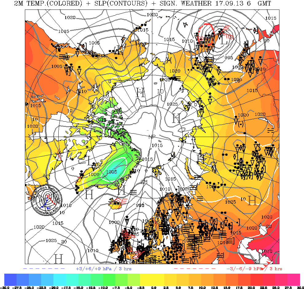
http://www.uni-koeln.de/math-nat-fak/geomet/meteo/winfos/arcisoTTPPWW.gif
-
Existing snow cover and snow currently falling in parts of Western Europe should aid cold pooling over Europe during the coming week. This can help to slow any Atlantic incursions with possible trough disruptions over the SouthWest of the UK as fronts approach from the South West and come up against what looks like becoming a very cold block over and the the east of the UK.
-
Fax charts are very late.
-
Correct me if I'm wrong, but once these systems have moved over land, they will drop a fair bit of snow over the European mainland, increasing the size and depth of the cold pool available when winds are steered in from an easterly quarter.
Yes this is often the case.
-
Thanks Stewart. That's the nearest to exasporated frustration I have sensed in your posts probably ever. Some posters on here cant see the wood for the trees...
Another thing that has to be taken into consideration is that the Artctic high which is already in position is currently driving very cold air towards Scandinavia and ultimately northern Europe and the UK. Once this cold is established it becomes much more difficult for the Atlantic to make inroads into the UK and shortwaves are inclined to run southeastwards into France and into the European trough.
-
This thread seems to have died.
Here's the temperature graphs for the 2011-12 season
This is fascinating as the marked warming in early to mid January appeared to link directly to western moving block over northern Siberia later in the month. The Siberian high migrated westwards at around 60 to 65 N maintaining a central pressure of 1060HPA over a period of a week or more. The result was a very unusual outbreak of Siberian air over the southeast of the UK and intense cold over much of Europe. I would think that actual Siberian air reaching the UK is a very rare event indeed and has probably only occurred on one or two occasions in the last 100 years.
-
A few of the GFS members show either a blocked pattern or things turning much cold/unsettled.
Control run goes for a blocked outlook in FI.
The stratosphere is currently warming quite markedly which appears to increase the chances of northern blocking so to see high pressure to the north in a couple of weeks time would tie in with the theory.
-
The continued predicted warming at 10hpa on GFS results in the PV that has been resident to the east of Greenland for most of the winter being entirely replaced by a significant warm area albeit deep in FI. If it verifies It will facinating to see how much this affects the troposphere during the second half of April.
-
GFS FI has been indicating a marked warming at 10hpa which looks as dramatic as the warming that occurred during January. This predicted warming looks more dramatic than what I would have expected for normal seasonal warming. If it verifies are we likely to end up with a Greeland high later in April with deepish cold air over the UK.
-
I think the question is now when will the final warming happen?
According to GFS 10hpa charts a warming started on the 18 February and is predicted to continue for a couple of weeks. It does not look as strong as the January warming but is nevertheless a warming. What effect this might have on March temperatures remains to be seen. I believe that It is thought that the warming in late December and early January contributed to the anomalous ridge over northern Russia in late January and during the first half of February that led to the extreme cold over Europe. The synoptic pattern during this time was highly unusual with high cells of 1060 hpa moving westwards at around 60 Deg north whilst maintaining their central pressure over a two week period. Was this extreme setup caused by the stratospheric warming or was it only part of the jig saw. The synoptic setup we have just experienced can only have occurred a few times in the last one hundred years. Winds from Siberia do not normally reach the UK but this year they actually did. Are we actually witnessing a more extreme climatic period and is the Stratophere behaving normally.
-
I would like to know what the wavelength is around the northern hemisphere at the moment at 500MB. I seem to remember that if is more than about 4000 miles the waves start moving backwards and we have retrogression. From the charts available it is difficult to measure
-
The predicted cold spell that is not going to happen according to some of the models wasn't going to happen until day 5 anyway and in 5 days time it still might happen - see UKMO 120 FAX with the hint of a block (diffluent/omega - cannot be sure yet) developing close by.
-
BBC monthly outlook from 16-22 Jan is completely at odds with the Meto update for the same period.
Meto saying below average temps and BBC saying mild or very mild!
What is going on!!
Seems strange - maybe the BBC forecaster is a mild ramper using old data and met office forecaster is a coldie using later data or vicer versa.
-
18Z GFS shows the low at T+120 slightly further south compared to the 12Z. I would imagine that during next week a storm surge could start to develop up the English channel. Also spring tides occur early in the week which would coincide with Tuesdays low.
-
A'hem..... its best to take everything after 72hrs with a pinch of salt not just the meto extended forecast..... Everyone should know that things change and can do so pretty fast. Only takes a few days for a pattern to change. Teleconnections including stratosphere can change suddenly too. It wasn't all that long ago we were told that tele's and stratospheric conditions would see us marooned under a renewed euro high and more settled milder conditions.. where's that senario now ?, still locked out in the deepest depths of model FI.
Best we don't to get hung up on dire output and forecasts imo.
You have a point. I was looking forward to the euro high that I am sure was modelled or suggested would appear around the 10 December which would have produced a more settled spell. It is true things change fast and sometimes within T+72. I do not know enough about teleconnections to form an opinion other than that I have observed that when sunspots are high, which they are at the moment, it often appears to be the case that the westerlies around the northern hemisphere seem to speed up. Extreme interludes do still occur and sometimes quite quickly.
The models often perpetuate the conditions that are prevaling at the time. If there is a cold spell they can model the next cold spell which never arrives e.g as happened in January 2011. If we are in a westerly as now the models can continue with this indefinitely then out of the blue something will change and sometimes within the T+96 timeframe.
-
http://www.uni-koeln.de/math-nat-fak/geomet/meteo/winfos/arcisoTTPPWW.gif
With a bit of imagination there is a northerly component in the flow at 60 deg north between the meridian and 90 deg W. Also notice how the flow crosses the pole and heads towards the UK. Greenland has a -40 deg isotherm the same as Siberia. No doubt this was modelled a few days ago but to see it in reality is quite striking.
-
All three main models continue to produce trough disruptions as the Atlantic troughs come up against the persistent ridge. GFS has the flattest shape but 12Z UKMO and 00Z ECM do have a better shape to the high at T+144.
-
The differences this morning start as early as 120hrs with the ECM/UKMO both taking a weak shortwave se off the main troughing, the GFS doesn't do this.It's hard to back against the Euros when they both agree within that range.
Later the ECM does have a more amplified upstream pattern but its hard to trust this model past 168hrs given some of its recent FI swings.
Whether we like it or not the Euro high is going to play a large role in proceedings, its just a case of whether we can get it into a more favourable position to deliver some surface cold.
The much maligned Azores high could play a role in something a little better even with the same overall pattern, slightly more amplification upstream digging that troughing further south, we might be able to carve out a shortwave into Europe from around the high, the Azores ridge moves ne slowing the Atlantic and you may just may get something more interesting, this is a longshot.
In these situations its often like pulling teeth to get the Euro high far enough north as the jet keeps trying to sink it. The ECM this morning is certainly the best output although the baseline isn't very high given some of the disappointing recent model runs and it has behaved more like the GFS in terms of chopping and changing in its FI.
So overall nothing majorly different this morning but a few more crumbs of hope.
Spot on analysis of this mornings output.

-
Inspite of GFS and the flatter ECM pattern this evening the best chance of cold is still with the ridge to the east. A temporary milder interlude later in the week before the ridge reasserts itself and increasingly cooler continental air feeds back across atleast the south and east.
-
UKMO disrupts the trough at around T+96 on 12Z run resulting in a cooling southeasterly for the southern half of the UK by 144. ECM and UKMO are now both tending towards a colder continental flow leaving GFS out on its own.

Winter Model Discussion - The Hunt For Cold -12z 14/12/12
in Spring Weather Discussion
Posted
The evening fax chart for T+72 hold the fronts approaching the UK further back and the Atlantic low further south than the previous run. Also the ridge that extends towards Sotland from the east is marginally stronger. No doubt the morning run will be more progressive once again.