


johnholmes
-
Posts
23,001 -
Joined
-
Last visited
-
Days Won
84
Content Type
Forums
Blogs
Gallery
Events
Learn About Weather and Meteorology
Community guides
Posts posted by johnholmes
-
-
Damp with hick fog; current low is 6.6 C
-
Cloudy with rain at times and a low of 6.9 C
-
Dry with clear skies; fog seems quite widespread E/S/N of here! Lowest temperature is 4.8 C so far
-
A cloudy start with rain at times; a low of 8.6 C
-
Dense fog at dawn, formed about 3am, thinned to about 300M by 8am and is probably about 6-700 M now, still sky obscured; temperature low of 6.1 C
-
Dry with patchy cloud, isol showers showing on radar, currently missing here; a low of 5.3 C
-
1 hour ago, johnholmes said:
Cloudy with ocnl slight rain, still not got rainfall ; a low of 8.7 C currently
Had about half an hour of moderate rain, see radar, once it stops I'll get the steps and have a look in the rain gauge, not sure if I will be able to sort it, just hoping its got something stopping the water draining out
-
Cloudy with ocnl slight rain, still not got rainfall ; a low of 8.7 C currently
-
Still chucking it down here, with the ocnl short spell of almost no rain, no idea how much, see above post, but never seen my main pond so high.
-
1 hour ago, The PIT said:
66.4mm here as well. Only coming down at 1.8mm per hour right now. Needs much more than that to keep rivers like the sheaf going up.
Don't wish for that-by the time the 3 rivers combine into the Don and it gets here things get pretty scary for a lot of folks.
-
2 hours ago, johnholmes said:
Still raining another 2.2 mm and the wind stronger, gusting to 37 mph, almost unheard of in my very sheltered back garden. the wx station is only 12-15 feet above the ground as well.
Davis Rainguage seems to have packed up around 0830, showing 27.0 mm+ 3.6 before midnight. Chucking it down currently is my technical term, certainly not going to go out and try to clear the Davis!
-
1 hour ago, johnholmes said:
Overnight wet and windy and still raining; rainfall from last evening to now=28.6 mm, overnight gust max=24 mph and a low of 12.7 C (currently)
Still raining another 2.2 mm and the wind stronger, gusting to 37 mph, almost unheard of in my very sheltered back garden. the wx station is only 12-15 feet above the ground as well.
-
Overnight wet and windy and still raining; rainfall from last evening to now=28.6 mm, overnight gust max=24 mph and a low of 12.7 C (currently)
Looks like my Davis has packed up with the rain, 0.2 mm in past 45 mins and only brief spells of not raining. For sure I'm not going out in this to try and rectify it!
Looking at the data output, probably suspect from around 0830 at a quick inspection.
-
Dry and cloudy after overnight rain; just 3.0 mm since midnight but 12.8 mm last evening; a low of 12.2 C
-
Dry and mostly cloudy, much milder with a low of 8.2 C
-
Dry with a mainly clear sky and a low of 3.3 C at the moment
-
Not looked in detail at the usual charts since Thursday last week so today
Monday 16 October
First NOAA 6-15 chart
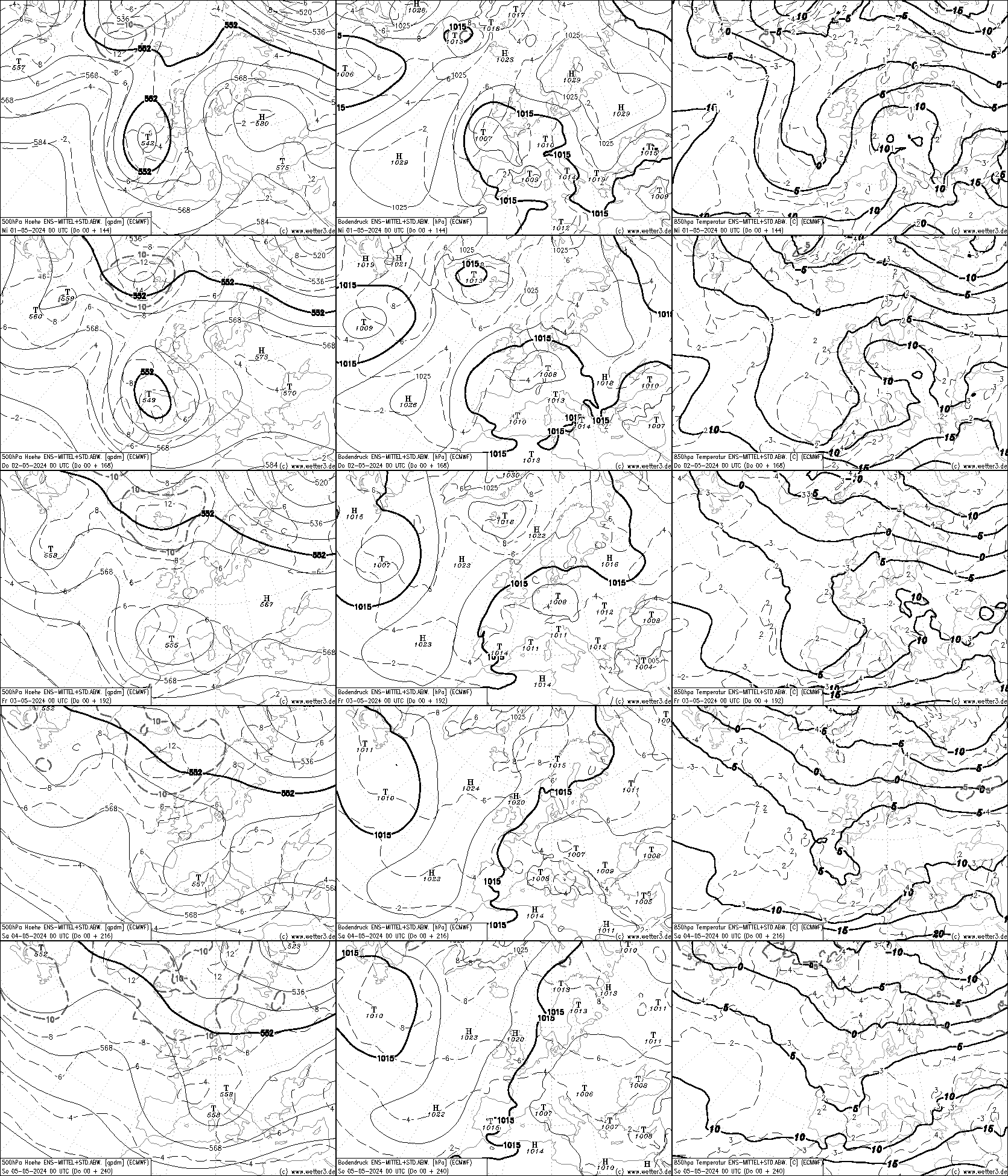
The large +ve values in the east Pacific of the last few days continues with a –ve value beneath this; so we have slight contour ridging where normally there is a trough and a small trough beneath this ridge, into a general weterly flow over N America into the distorted pattern south of Greenland into western Europe, with a marked ridge off western Norway towards Greenland, with a +be anomaly of around 180+ DM. Again this has been showing for several days. The overall pattern across the Atlantic and into much of western Europe is westerly, with a change to a more S’ly over the UK and far NW France/Scandinavia. The 8-14 loses most of the +ve heights along with much of the ridging.
For the ECMWF output for 22-26 October (much the same period as NOAA 6-10) the 500 flow starts with an very similar one to NOAA. It becomes less distorted over time but remains first N of West and then more westerly by 26 th. The 850 temps are generally showing around + 5 C with some warm up towards the end as the +5 C moves into the SE of England.
Overall the two suggest somewhat less cold air slowly developing as the trough slowly warms out slightly. The settled dry spell initially probably becoming less settled with time.
 Climate Prediction Center - 6-10 Day 500mb Outlook
WWW.CPC.NCEP.NOAA.GOV
Climate Prediction Center - 6-10 Day 500mb Outlook
WWW.CPC.NCEP.NOAA.GOV
Original post: https://community.netweather.tv/topic/99428-model-output-discussion-mid-autumn/?do=findComment&comment=4937813 -
- Popular Post
- Popular Post
Not looked in detail at the usual charts since Thursday last week so today
Monday 16 October
First NOAA 6-15 chart
The large +ve values in the east Pacific of the last few days continues with a –ve value beneath this; so we have slight contour ridging where normally there is a trough and a small trough beneath this ridge, into a general weterly flow over N America into the distorted pattern south of Greenland into western Europe, with a marked ridge off western Norway towards Greenland, with a +be anomaly of around 180+ DM. Again this has been showing for several days. The overall pattern across the Atlantic and into much of western Europe is westerly, with a change to a more S’ly over the UK and far NW France/Scandinavia. The 8-14 loses most of the +ve heights along with much of the ridging.
For the ECMWF output for 22-26 October (much the same period as NOAA 6-10) the 500 flow starts with an very similar one to NOAA. It becomes less distorted over time but remains first N of West and then more westerly by 26 th. The 850 temps are generally showing around + 5 C with some warm up towards the end as the +5 C moves into the SE of England.
Overall the two suggest somewhat less cold air slowly developing as the trough slowly warms out slightly. The settled dry spell initially probably becoming less settled with time.
Climate Prediction Center - 6-10 Day 500mb Outlook
WWW.CPC.NCEP.NOAA.GOV
-
 5
5
-
 2
2
-
 4
4
-
Dry with quite a lot of cloud, a low of 1.9 C, so ? if there has been any ground frost, now on 2.3 C
-
Sunday starting with a clear sky and patchy ground frost with a low of 1.6 C, now 2.3 C
-
Dry with variable cloud and a low of 6.2 C
-
After a dry rather bright spell late am more rain now up to 13.6 mm and 11.6 C; this time last Friday it was 22.7 C. Welcome to autumn
-
Rain at times with temps around 11.7 C at their lowest, up to 12.4 C now, rainfall since midnight=10.5 mm
-
Thursday 12 October and another look at NOAA and ECMWF 6-14 days from now
Noaa has a marked build of heights over Scandinavia since Sunday’s chart; the main trough is now over and south of Greenland with a very slack S’ly flow into the UK. The pattern remains much the same on the 8-14 chart with +ve heights showing around 180 DM over the western coast of Norway. This evolution is similar to that from ECMWF with it showing a surface central pressure of 1034 MB just off southern Finland. So it would seem a spell of mostly dry weather with cloud amounts rather variable giving many sunny spells at least with clear spells
overnight=around normal temps by day and rather cold at night with frost in areas away from coasts. Obviously detail will come from the synoptic models over the period=6-14 days.
sorry missed this off about 850's
The 850’s suggest temps below average at the start but rising a bit above by the end, especially southern areas
Climate Prediction Center - 6-10 Day 500mb Outlook
WWW.CPC.NCEP.NOAA.GOV
Original post: https://community.netweather.tv/topic/99428-model-output-discussion-mid-autumn/?do=findComment&comment=4935969


Daily weather observations - October 23rd to October 29th
in Spring Weather Discussion
Posted
Foggy with a current low of 7.1 C