


johnholmes
-
Posts
22,977 -
Joined
-
Last visited
-
Days Won
84
Content Type
Forums
Blogs
Gallery
Events
Learn About Weather and Meteorology
Community guides
Posts posted by johnholmes
-
-
Lovely day here, blue sky hardly any breeze T=12C and Td=9C
-
 2
2
-
-
re the poster asking about Wengen
This is the link to give the local forecast, slope information etc
 Slope data | jungfrau.ch
WWW.JUNGFRAU.CH
Slope data | jungfrau.ch
WWW.JUNGFRAU.CHI skied there for about 32 years from 1988 staying at the Alpenrose. Wonderful area but don't expect massive snowfalls but enough most years to ski from the top of the Lauberhorn into the village, even try the Lauberhorn race track. Not sure if it is open prior to the race in early January. The scenery is really stunning, skiing also at the other two villages, Murren and Grindelwald, Murren is a steeper resort for runs.
Enjoy if you go; going to get mushy this next week. But most models are suggesting a burst of cold air again into Europe in the lead up to Xmas.
If you would like to chat then drop me a line, happy to talk snow and Wengen!
-
1
-
-
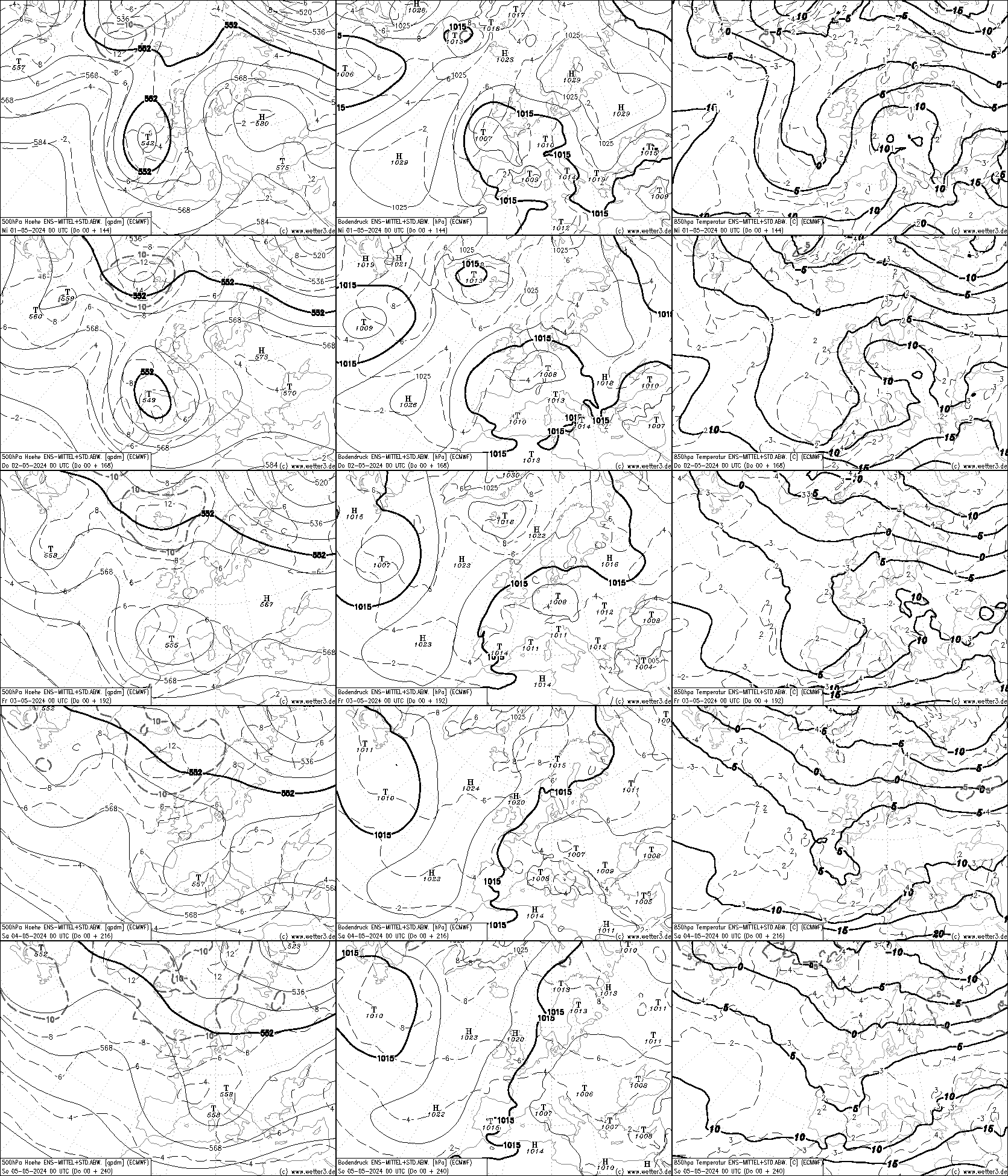
Well some 3 days since I posted the NOAA and ECMWF latest charts, the 6-10 day issue takes us into the Christmas period. I wonder if they suggest a cold one?
NOAA 6-10 out to 23 December and it is showing a very strong westerly into the UK. This from a fairly marked trough off the west coast of north America, into a slight ridging east of this with the westerly over the rest of the chart into the UK. Heights around the Border region are on the lowish side at about 540 DM; (I might be 6DM out as the gradient is so strong making it hard to decipher the actual height). It also suggests, with a large temperature gradient in the east of n America, that there is a good chance of it being a windy and unsettled period in much of the UK. With fairly low heights then wintry type ppn from about the Peak District north on high ground and low ground in the more northern parts of Scotland would be probable. At this distance suggesting anything more detailed is a waste of time. The 8-14 shows 534 DM in the Border area so remaining on the cold side of normal and further disturbed weather likely. That is assuming these two charts are on the correct lines!
Turning to ECMWF, period 20-24 December, and it shows a 500 mb trough just east of the UK, extending SE with a strengthening north of west flow which has backed slightly and also decreased a bit in strength by Xmas Eve. The 850 values are around zero C for much of the country most of the time; the colder air -5C is predicted to be largely well into Europe even in the centre of the extended trough.
Both sets of chart do suggest colder than rather than above normal temperatures. So I’ll be watching how they both develop over the next 3-7 days!
Looking just above my post I see Mike is in about the same place as me!
Climate Prediction Center - 6-10 Day 500mb Outlook
WWW.CPC.NCEP.NOAA.GOV
Original post: https://community.netweather.tv/topic/99584-model-output-discussion-into-winter/?do=findComment&comment=4976321-
1
-
-
- Popular Post
- Popular Post
Well some 3 days since I posted the NOAA and ECMWF latest charts, the 6-10 day issue takes us into the Christmas period. I wonder if they suggest a cold one?
NOAA 6-10 out to 23 December and it is showing a very strong westerly into the UK. This from a fairly marked trough off the west coast of north America, into a slight ridging east of this with the westerly over the rest of the chart into the UK. Heights around the Border region are on the lowish side at about 540 DM; (I might be 6DM out as the gradient is so strong making it hard to decipher the actual height). It also suggests, with a large temperature gradient in the east of n America, that there is a good chance of it being a windy and unsettled period in much of the UK. With fairly low heights then wintry type ppn from about the Peak District north on high ground and low ground in the more northern parts of Scotland would be probable. At this distance suggesting anything more detailed is a waste of time. The 8-14 shows 534 DM in the Border area so remaining on the cold side of normal and further disturbed weather likely. That is assuming these two charts are on the correct lines!
Turning to ECMWF, period 20-24 December, and it shows a 500 mb trough just east of the UK, extending SE with a strengthening north of west flow which has backed slightly and also decreased a bit in strength by Xmas Eve. The 850 values are around zero C for much of the country most of the time; the colder air -5C is predicted to be largely well into Europe even in the centre of the extended trough.
Both sets of chart do suggest colder than rather than above normal temperatures. So I’ll be watching how they both develop over the next 3-7 days!
Looking just above my post I see Mike is in about the same place as me!
Climate Prediction Center - 6-10 Day 500mb Outlook
WWW.CPC.NCEP.NOAA.GOV
-
14
-
 4
4
-
 6
6
-
A ground frost early on with a low of 0.1 C then slight rain with 0.6 mm since midnight, dry now with temperature up to 3.0 C
-
Overcast, dry after slight rain in the early hours; 0.4 mm since midnight, temp is still drifting dow, low currently at 6.2 C
-
Dry now after overnight rain=3.8 mm since midnight; a low of 5.4 C
-
- Popular Post
- Popular Post
No signal for any 'deep' cold on either NOAA or ECMWF, NOAA 6-10 and 8-14. Of course they might be wrong but in 12 years or so using them it is fairly unusual, especially with the 6-10. Anyway I'll post them below for anyone who wants to have a look themselves.
A big thank you from me to snowking also
Climate Prediction Center - 6-10 Day 500mb Outlook
WWW.CPC.NCEP.NOAA.GOV
-
19
-
3
-
Dry and mostly cloudy as far as I can see, 0.2 mm since midnight and a low of 6.8 C
-
Starting with rain (radar suggests several hours more; a low of 5.7 C
-
Mostly clear skies, dry and a low of 5.2 C
-
1509 and almost dark with rain at times, temperature has struggled up to 5.8 C-wonderful!
-
- Popular Post
- Popular Post
4 minutes ago, E17boy said:
Dear High pressure
I am writing with reference to your movement and travels in the coming days. As you know with the news that you are heading to our shore , I would just like to put a special request in for your direction of travell. Many coldies like myself are waiting and watching you as this will have huge future impacts as to where our goods come from in the coming days.
We have many wintry products including ice, severe cold and heavy snow that are in huge demand by the coldie market here in the uk. Our main suppliers East wind in located in Siberia and NE wind in Scandinavia need a good transport infrastructure in order to send these products here.
With all this in mind your role in where you sit will be very important. It is advised that if you could possibly set up base in Scandinavia or Greenland this will open the way to receive our goods here in time for a good Christmas present for our coldies. Your base will be secure and we would like this to be a long term setup as we have only started our sales season which we hope this will be good for the coming next 3 months.
I very much hope you will look into my request with great consideration and fulfill my desire. I look forward to continuation of our relationship in the coming days. My staff GFS, ECM, CFS, UKMO and the Pub run will all be updating me daily on your movement.
Thank you again
Kind regards
Lovely post, so good to have a bit of humour in here but still get the coldie wish across
Lovely to get the coldie message across in such a light hearted
-
14
-
3
-
3 minutes ago, Daniel* said:
Hi John for a netwx legend of course! Hope that’s better.
many thanks Daniel, how do I do that for other charts that get posted please; sorry to be a pain
-
1
-
-
31 minutes ago, Daniel* said:
Yes, here as animation nice bit of retrogression. Seems to align with EC46.
Is it possible to slow it down please then my old eyes might be able to follow what is happening along with the time scale
thanks for any help
-
2
-
-
4 hours ago, SouthYorks said:
Yeah, cold one last night. Interesting though that my ‘overnight low’ actually occurred at 8.14am, when I got to -3.5c
Mine was similar timing. This will be a feature of any frosty mornings until about the end of the 1st week of January when we have full radiation nights and the late sunrise.
-
2
-
-
- Popular Post
- Popular Post
Looking at the ECMWF output from 12-16 th December=upper trough giving way to upper ridge with surface high near by to SW. So generally dry, rather cold becoming less cold, rather above normal for most of the country?
-
8
-
2
-
Clear blue start with another white frost and a low of -2.7; the 4th air frost this month
-
Looking at the NOAA 6-14 day charts and no signal at all for a change to a general westerly upper flow, similar on the ECMWF, time scale on that similar to the NOAA 6-10. Little showing way out west to suggest any change just yet
Climate Prediction Center - 6-10 Day 500mb Outlook
WWW.CPC.NCEP.NOAA.GOV
Original post: https://community.netweather.tv/topic/99584-model-output-discussion-into-winter/?do=findComment&comment=4970389-
2
-
-
- Popular Post
- Popular Post
Looking at the NOAA 6-14 day charts and no signal at all for a change to a general westerly upper flow, similar on the ECMWF, time scale on that similar to the NOAA 6-10. Little showing way out west to suggest any change just yet
Climate Prediction Center - 6-10 Day 500mb Outlook
WWW.CPC.NCEP.NOAA.GOV-
5
-
5
-
5
-
Dry at the moment but a fairly wet night (4.4 mm) following a wet cold day yesterday 11.8 mm and a max of 5.2 C, so far the min overnight shows 5.1 C
-
- Popular Post
- Popular Post
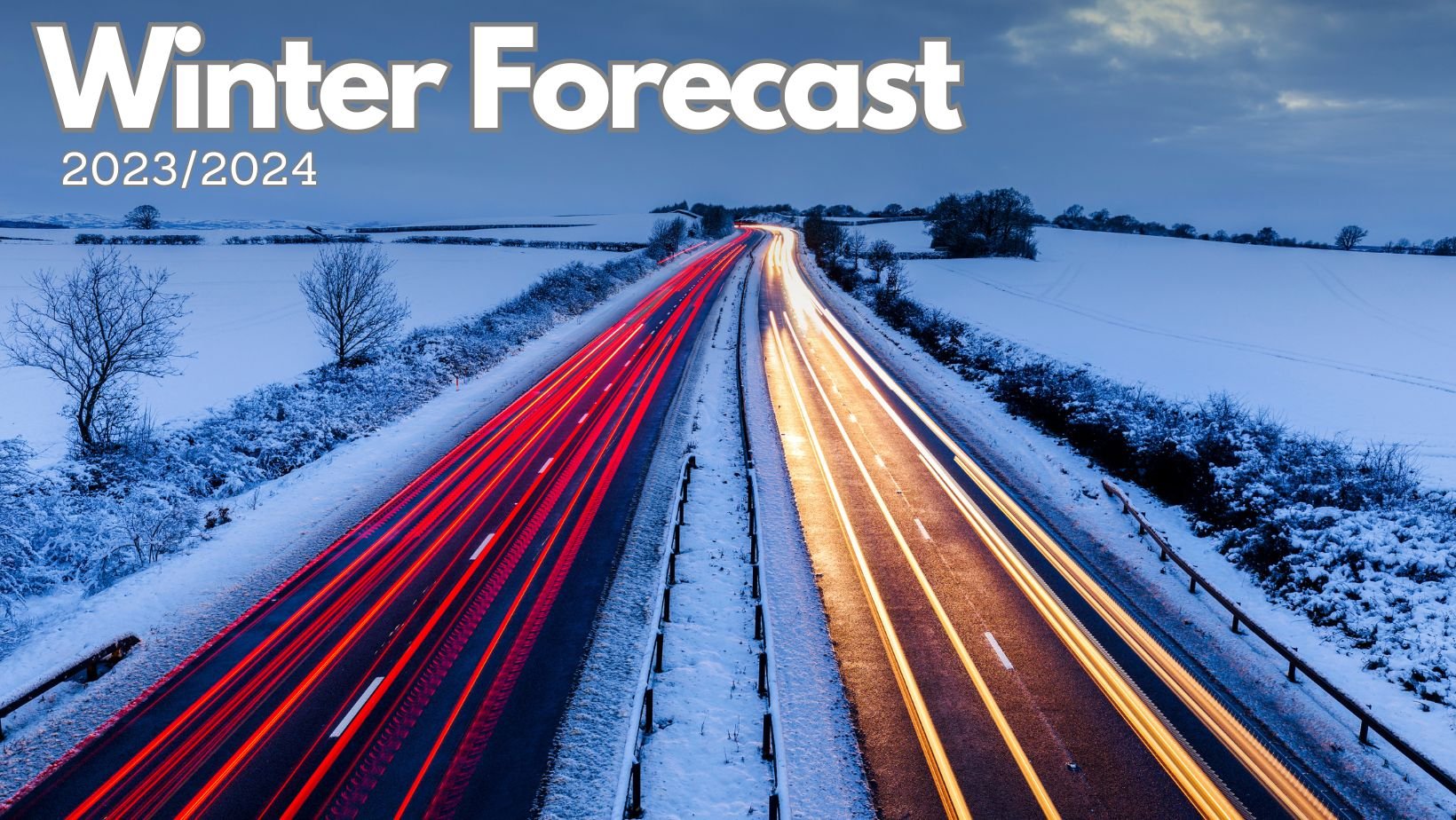
1 hour ago, Jo Farrow said:Nick's Winter outlook is now on the website. A lot of effort and research has gone into this, with perhaps the best setting of falling snow last week whilst it was finished off.
Long Range Weather Forecast - Winter 2023/2024 | Netweather.tv
WWW.NETWEATHER.TV
Long range weather forecast for the UK - Winter 2023/2024. Will it be a cold winter?Wow what a huge task this is, it seems to get larger each year as the knowledge increases. Fantastic Job Nick-thank you. It seems a long time since you first arrived and we used GFS 4x outputs to try and do a daily forecast!
-
34
-
Raining again, 7.2 mm since midnight but some might be melted snow from 24 hours ago, from a low of 1.4 C at midnight it has risen to 4.3 C and still edging up
-
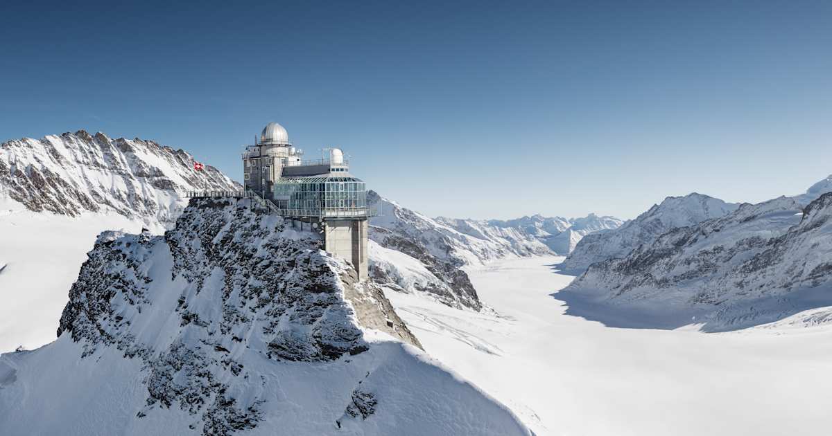
This at the Lauberhorn start area, think there are 4 or 5 lifts open this weekend
https://www.jungfrau.ch/webcams/lauberhorn/#/
-
1
-


Winter 2023/24 Chat and Discussion
in Spring Weather Discussion
Posted
My favourite spot, if only I was 10 years younger, lovely day there