


Virtual Chase Thread 2011
-
Recently Browsing 0 members
- No registered users viewing this page.
-
Our picks
-

Birth of a thunderstorm
Sky Full posted a gallery image in Member's Gallery,
Birth of a thunderstorm - captured by Sky Full-
-
- 0 replies

Picked By
Paul, -
-
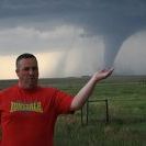
TOUR 2 Tornado Alley
Tom Lynch posted a topic in Storm Chase USA,
Tour 2 of the USA storm chase is currently underway, and the team has already witnessed a one-mile-wide tornado.-
- 9 replies
Picked By
Paul, -
-
Storm Chase Tour 1 2024 - Photos and Highlights
Paul H posted a post in a topic,
Highlights and photos from tour 1 of the WeatherHolidays USA storm chase - including bonus Northern Lights.
Picked By
Paul, -
-
Northern lights spectacular May 2024
Eagle Eye posted a post in a topic,
Amazing Aurora photos from last night.
Picked By
Paul, -
-
Major USA tornado outbreak possible
WeatherArc posted a post in a topic,
A major tornado outbreak is possible in Kansas and Oklahoma on Sunday 6th, May.
Picked By
Paul, -
-
-
Latest Weather News
UK weather for 4th July after the soggy General Election announcement
The UK General Election announcement had a few distractions including pouring rain. The 4th July date gives hope of summer sunshine and warmth but that is not always the case Read more here

Bank Holiday weekend weather update. A showery Sunday
No heatwave or washout for the Bank Holiday weekend but there will be warm sunny spells but plenty of showers, particularly on Sunday. Read the full update here

WeatherHolidays Tour 2 seeing plenty of action including tornadoes this week
I'm catching up with tour 2 of WeatherHolidays storm chase, which is out in the US Plains at the moment. They've had plenty of action in the first five days of the tour, including several tornadoes in Iowa and Oklahoma. View the full blog here


Recommended Posts
Create an account or sign in to comment
You need to be a member in order to leave a comment
Create an account
Sign up for a new account in our community. It's easy!
Register a new accountSign in
Already have an account? Sign in here.
Sign In Now