-
Posts
2,179 -
Joined
-
Last visited
Content Type
Forums
Blogs
Gallery
Events
Learn About Weather and Meteorology
Community guides
Posts posted by Jason M
-
-
GEFS just hinting at possibility of easterly in deep FI. Be very wary of this signal IMHO as from experience likely route forward from around day 12 would be mid lat high with bulk of any cold eventually sinking away to our SE.
Only route I see for proper cold would be a cold pool dragged westwards round the base of a mid lat high to our east. In essence an E/SE wind off the continent. Can happen at this time of year.
I reckon we will see some big easterlies modelled in the next few days, but I won't be buying as I think we are destined for a watered down version.
-
 1
1
-
-
-
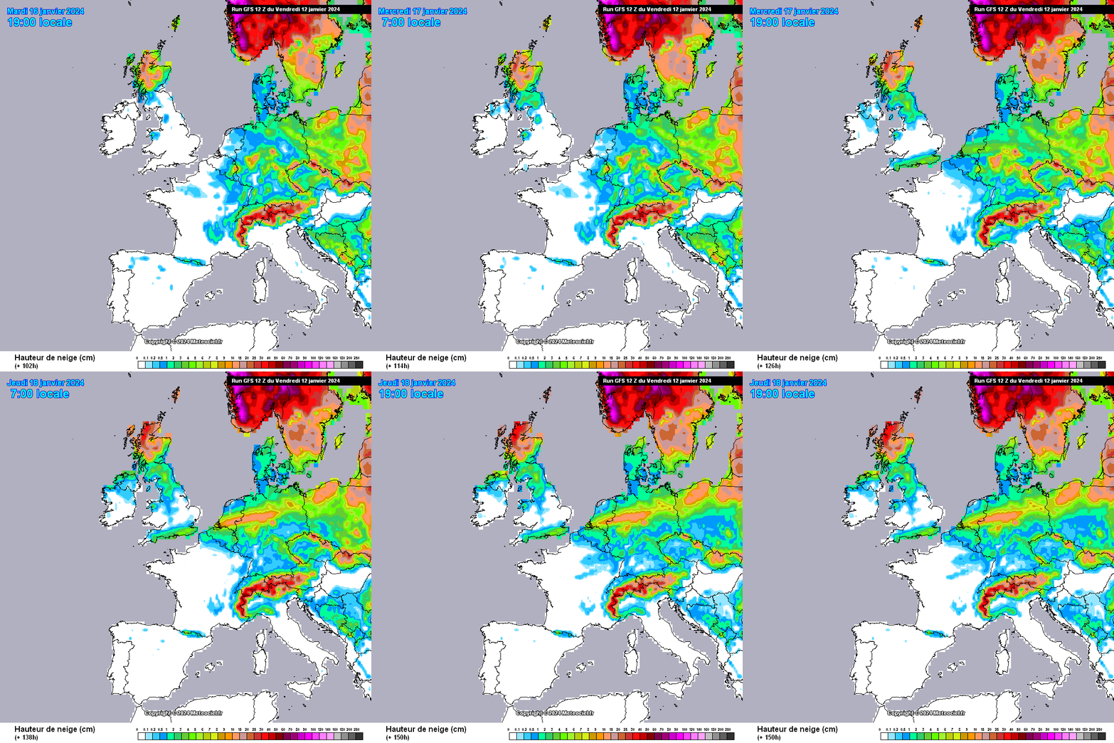
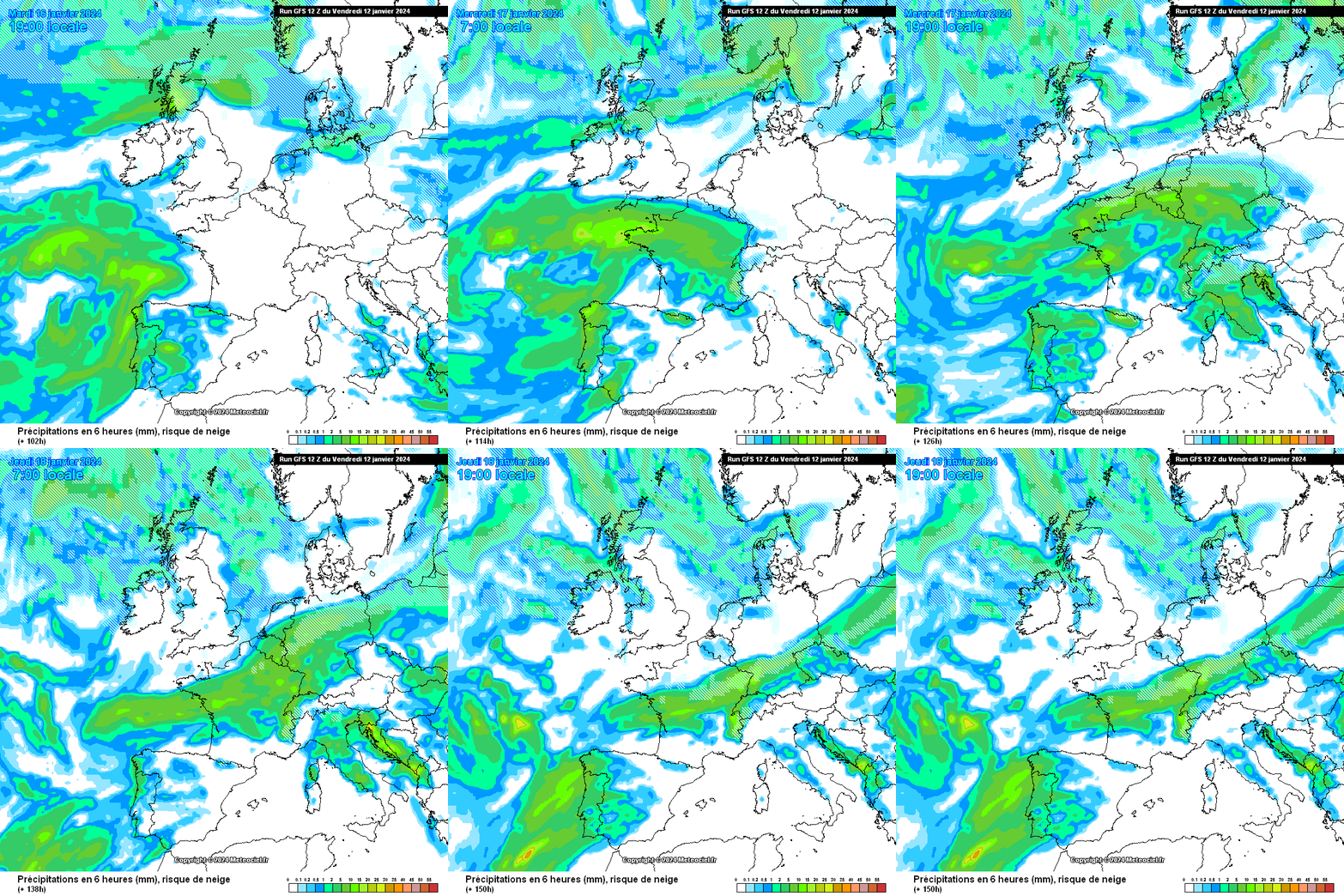
GEFS out to 108 and there is still a lot of uncertainty around that time frame with the chance of snow in the south.
Its one of those weird situations where there is a lot of short term uncertainty but the longer term position is much clearer.
-
 9
9
-
-
Just now, Kasim Awan said:
Never once looked favourable for more than 4-5 days of cold / snow in the North.
I largely agree. We may still have some drama midweek with the low and its exact track in the south / midlands.
Seeing an increasing tendency for height rises to our south after next week and if that comes to pass, there is only one outcome from that.
-
 2
2
-
-
20 minutes ago, IDO said:
A lot of warmth is also present though and snow band on northern edge will be narrow. Its a system formed from a very long way south.
-
 1
1
-
-
Just looked through latest GEFS out to 240.
Ensemble member 7 shows a seamless transition into a potent easterly (which does make sense). Its a lone ranger though within the suite and most show a move to milder with a strong build in heights to our south.
-
One of those situations where lots of short term inconsistency and different routes that can be taken, but all roads seem to be leading to the same place by next weekend.
I suspect next week won't be quite as dry as the charts currently look. Thereafter I was hoping to see height rises towards Scandi but the window for that seems to be closing rapidly and we are not really seeing much if any suggestions of it happening in a meaningful way in any of the ensemble suits (not seen the latest GEFS yet).
So, in summary a decent winter cold spell with some snow about but right now its not looking like anything memorable for most people (deliberate use of 'most' here instead of 'all' before any toys are thrown!). Snow potential could increase next week though and I wouldn't be surprised to see some shortwaves get modelled through the channel even if the main low stays well south.
Longer term modelling is suggesting strongly a much milder, wetter end to the month and it will be interesting to see how that plays out against the background drivers being discussed on here. Place your bets!
-
 5
5
-
-
Just now, Jason T said:
Blimey' reading through the last 5 pages I'm more confused now than when I started reading the first page. Anyone shed some laymen terms on where we are. On' off' on 'off' snow' rain' no shortwave' now a shortwave' disombobulatded
That's as good a summary of the situation as you will get

-
 6
6
-
 1
1
-
 1
1
-
-
5 minutes ago, GokouD said:
Wow, that would be genuinely heart-breaking IMBY... I'll just have to try and be happy for the Southerners haha.
Yes, you will be missing out on all that rain

Lot of warmth tied in with this system. Somewhere is going to get lucky but there is going to be some pretty warm air in with that system so its not a channel runner in the traditional sense. Band of snow on its northern flank could be quite narrow.
-
Well, looking through the GEFS and just taking a snapshot of where each member is at 192 hours, good luck to anyone who thinks they can make a forecast with any confidence

Most are cold, but beyond that chaos reigns.
-
 7
7
-
 1
1
-
-
We want the low to go south. This is a really pivotal moment in the season and if we can get the low south many more snow chances will follow for all I suspect.
-
 2
2
-
-
Just now, ICE COLD said:
The control is just another ensemble member , ran at the same resolution as the other ensemble members I believe. The op is higher resolution than the rest .
But starts with the same data as the opp.
I'm not saying it will be right. I'm just saying don't discount it.
-
Just now, SussexSnow said:
There's the reason, a 17C range - with the GFS Op right at the top of the spread.
Yes, but control and Opp running together at day 8 cannot be ignored.
-
2 hours ago, Bricriu said:
It looks like a lot of ensembles are trending the wrong way in fi contrary to the op runs. It's a long way out anyway to worry about it. Also there is a chance they could change to extending the cold. As long as the UKMO update remains bullish about the long range I am happy enough.
100%. I was just explaining why they were not great.
The GFS opp was a huge cold outlier but it made sense to me so although anything that far out is complete guesswork for our tiny Island, I'm thinking the opp made more sense than GEFS.
-
 1
1
-
 1
1
-
-
- Popular Post
- Popular Post
2 minutes ago, johnholmes said:Is it me, perhaps I'm seeing something that is not correct?
Most avid followers seem in despair after each 00z GFS run, fairly elated then after almost each 06Z and 12Z runs?
Always been the way.
18z provides the booze
00z gives a hangover
06z provides the Nurofen
-
 33
33
-
-
Anything after day 10 is a waste of pixels IMHO. Right now probably anything after day 5!!!
However, that said, the GFS opp run all the way out to the end is actually very plausible. Not saying it will be right or even close to correct, but it does make logical sense in its evolution to me

-
 2
2
-
-
Just ran through the GEFS at 192.
Anyone wanting to make any sense out of them is going to be a better man than me!!
Colder than last set, but clearly very high levels of uncertainty and I suspect across all output we may see wild swings in coming days.
-
 2
2
-
-
Just now, Cableguy said:
How is it that thoughts on UKWW forum are totally at odds with what's being said here?
Confused!
Do share what those thoughts are?
-
 4
4
-
-
2 minutes ago, Ali1977 said:
Full on snow that I’d say
Yep, running into established cold air, anywhere with 850s below zero is seeing snow at that point IMHO.
-
 5
5
-
-
45 minutes ago, northwestsnow said:
My preference is the snowline stays south of the Midlands actually.
That way more people see snow and those of us North of the snow will hopefully see lots of snow showers and frosty nights.
Think your right about this. If it gets up as far as you its going to be snow to rain and the fat lady will be belting out her latest hits.
-
 1
1
-
-
11 minutes ago, TillyS said:
If there are insufficiently cold uppers in advance of the low it will be another ‘meh,’ which is how I’ve been feeling generally about this cold spell. It promised much but hasn’t so far produced a lot.
I’m not convinced this northerly is going to be potent, or advance far enough south in terms of deep cold, to get too excited about this. The number of times northerlies get watered down is myriad.
My weariness with this cold spell comes from watching the ensemble trends. But perhaps things will change. There’s still lots of time and the fact that the UKMO is uniquely holding out (not even the ECM does now*) is quite something.
*Re the ECM: as John Holmes has just posted
Its really only felt like a couple of days worth of Cold Northerly to me, so were in the same camp I suspect.
There is still the chance though that this low will stay South and that could really dramatically impact things going forward.
Even if the low comes north I think it will be a slow process so we could see quite a few hours snow before it all goes back to rain.
-
 3
3
-
-
3 minutes ago, northwestsnow said:
I suspect t the Exeter update will reveal if they are going with GFS/GEM V UKMO /EC..
I'd suggest the envelope for the sweet spot is somewhere around the Scottish Borders to Birmingham as it stands -
That might move north or south as the envelope narrows ..
In set ups like this (from experience), the low will either miss us to the south or its game over for everyone (i.e. snow to rain event for all).
If the low comes north its going to be a very concerning time re floods because it looks to me that in the week or so after we will see enormous rainfall totals. So for both coldies and people near rivers I hope the whole lot ends up in northern France on this occasion.
-
 7
7
-
-
I've just looked through the GEFS at 216 hours.
There are some stonkers in amongst them. The 00Z GEFS were dreadful but this set is much better around that timescale.
This is going to be an extremely tight run thing. A difference of a couple of hundred miles in the pattern is going to have very big ramifications.
-
 6
6
-


.thumb.png.30fc48c10426cf6c0ece4b4c1ff77a30.png)

Model Output Discussion - Colder but how cold and for how long?
in Forecast Model Discussion
Posted
They are going mid lat route. High sat over say Germany / Low Countries. I think they will be right. Just cannot see a genuine high lat block setting up.