


gareth moo
-
Posts
176 -
Joined
-
Last visited
Content Type
Forums
Blogs
Gallery
Events
Learn About Weather and Meteorology
Community guides
Posts posted by gareth moo
-
-
Magic ECM output this evening showing decent frontal snow for Wales next weekend. Fingers crossed for upgrades because its marginal as always!
-
Some great charts showing up for next week. Colder and colder air flooding in and plenty of instability too.
Lamp posts at the ready?!
-
Growing excitement in the model thread today. (They'll probably be back to wrist slitting tomorrow!)
Looks like some kind of Atlantic block is on the cards for this weekend onwards. Some early talk of Northerly air and white stuff.
Could this be the year when we are eventually 'the right side of marginal' in Wales? Time will tell.
-
Incredible and weird sky this morning out there. So dark. All building and street lights piercing through the gloom at 10.30am but no rainfall around.
Guess it must be the result of Ophelia and maybe some Saharan sand thrown in the mix from the Southerly flow?
-
3 hours ago, Blessed Weather said:
Blue sky this morning!!!

Avalanche cannons have been booming away from first light and clearly the resort is taking no chances as we've been watching a helicopter flying around the mountain also dropping explosives onto any area that might pose an avalanche risk. But it's looking promising - hopefully most areas of the mountain will be open today.
Jealous! x100.
Remember what's always socially acceptable - "No friends on a powder day!"
-
 1
1
-
-
Thanks for the update. Looks amazing. Hope the sun shines for you later in the week but stay safe. I would expect avalanche warning upgrades to level 5 tomorrow!!
-
1
-
-
On 05/03/2017 at 21:08, Blessed Weather said:
Yes, exceptionally quiet on the pistes today. Usually it's busy on a Sunday as you get weekend skiers from local towns in France, plus a fair contingent coming over from Italy. We reckon they all read the forecasts of heavy snow and stayed in bed!!
It's still snowing very nicely this evening, so maybe the forecasts of a good fall are finally coming right!
A photo of Lanslevillard 'old town' this evening (where we stay). Lanslevillard at 1,450m is one of several small villages that make up the resort of Val Cenis.
How's today's storm developing there Malcolm? My friend who is living in Les Arcs has reported an almighty dumping with thunder snow! Radar looks interesting!
-
34 minutes ago, seaside 60 said:
Yet in Katschberg (Austria) I only see under 6cm after tonight until sunday and thats at 2200m.
Are you sure thats not dodgy data or forecast for 3500m, as freezing level is around 1900m and not going above -4c.
Ok just had a chance to check the facts.
You have cherry picked 2700m lol, at 1650m you have 3 days rain and around 50cm of snow.No cherry picking at all lol. I'm not going there anyway.
Just pointing out to the good folks in here that some areas are going to do very well in the next week.
On the topic of Vaujany, it's a great village that has expanded hugely in the last few years but has kept it's traditional feel. I've been going there for 20+ years and will be back at Easter for a fortnight with both skis and MTB. Outstanding ESF ski school and regular open races (for kids and adults) with coaching if that's your bag.
-
1
-
-
Mid station forecast. Yes very high altitude at 2700m. Top of Glacier Express gondola probably. Top of Klein Matt lift is 3820m though and showing even more!
-
Wow! The GFS data on Snow forecast.com has somewhere over 200cm forecast for Zermatt in the next 6 days.
-
1
-
-
100% spring conditions in Alpe d'Huez this week. Poor snow base has bare patches showing even at 2000m. Without significant natural snowfall within the next few weeks, there is little chance of them making it to what is a late Easter.
-
Anyone on here in or between Builth Wells and Hay on Wye? There's elevation there, its inland and in the path of the best streamer so far. Would imagine that it's going to be pretty good viewing up that way?
-
59 minutes ago, gareth moo said:
Would be great to see some snow this week but next week is where its at folks.
Battleground potential for sure. More output needed but will be exciting to watch it unfold.
I take it back. GFS has just thrown us a Thursday afternoon and evening surprise. PPN pushed further north therefore rain turning readily to snow, particularly in SE Wales.
-
2
-
-
Would be great to see some snow this week but next week is where its at folks.
Battleground potential for sure. More output needed but will be exciting to watch it unfold.
-
1
-
-
Just a minor 110cm of snow forecast for Avoriaz in the next 5 days or so !!!!!!!!
(Based on GFS precip charts!)
-
1
-
-
7 hours ago, WINTRY WALES said:
Morning Gareth
We have ended up booking a place down in La Brevieres which I understand is at the bottom of Tignes. This basically due to availability and price plus the Mrs wanted some spa facilities in the hotel
. Any how looking at the forecast this week some much needed snow on the way (if I read the charts correct haha) plus we have a car so we can get around an explore. Well here's hoping all of us who's travelling get lucky with some fresh dumps soon...and who knows we may have a taster ourselves this week in the UK!
Cheers
WW
Great choice- certainly a more authentic Alpine village. Love it down in Le Brev between the trees. Snow fortunes looking better too!
P.S. The bar next to the gondola just over the river bridge on the left has top quality vin chaud!
-
1
-
-
12 hours ago, keithlucky said:
Nice to so see possibilties of some cold Nwesterly flow with some heavy prolonged wintry showers on its way thorsday Friday next week
But what i find even more intersting is that the met are struggling to handle further outlook beyoud 6days ,The models cannot seem to handle a possible complete turn around to East or a N east flow ,expect some excited model forun watches next week.
Yes Keith. Things firming up for potential late next week into weekend. It's only potential as yet and as always since 2010 'Marginal' is the key word. However, we often do well from a NW flow - streamer time maybe??
-
2
-
-
Yep. I think that 30cm was a snow-starved exaggeration although there may have been something more reasonable on the Aiguille Rouge. He's been there over a month and hasn't been off piste yet!!
Tuesday looks like the next good opportunity for Savoie and Isere. Fingers crossed.
-
2
-
-
On 04/01/2017 at 15:18, WINTRY WALES said:
Hey great to hear off you all again any some details of your trips! Much appreciated.
Out of interest I am thinking of going to Val D'isere (expensive option) or neighbouring village Tignes (cheaper) in around 2 weeks.
Anyone tried these resorts??
Cheers
WW
Tignes is a fantastic all round resort with a huge variety of skiing - with some amazing off piste areas if that's what your looking for. I also agree with Malcolm that Le Lac, although not pretty, is the best place to stay if you want access to the whole area including Val d'Isere. La Folie Douce is completely mental and always worth a visit especially after 3pm when it really starts bouncing. (I have also paid a visit to the equally insane Alpe d'Huez and Val Thorens branches of the chain). However, if you're staying in Le Lac don't be late back to the Tommeuses chair as it closes at 4.45 I think. The black run back home in the twilight with a few beverages on board is generally quite 'eventful.' Tignes is an open bowl area so visibility can be compromised in poor weather although there are some lovely tree lined runs down towards La Brevieres and on the lower slopes in Val at La Daile, Fornet and Solaise. Highly recommended - and the central private accommodation agency is super efficient via their website if you want to go independenly.
-
3
-
-
Good news. 30cm of fresh snow reported from my friend who is doing a season in Les Arcs. Don't know where this came from because the models were looking pretty dry.
-
1
-
-
7 hours ago, whiskers said:
I'm so cofused!! I was all excited coz of the best winter cold setup,that went,that was gutting,in the forum there's lots of confusion there is cold there's not cold,what's going on???
Patience. It's coming.... Loads of background signals and proper cold now knocking upon the European door. If the deep cold invades Europe, we can pick up a cold source from an additional bearing. Just need to get rid of this stubborn lingering HP to our South.
-
Eastern Austria is the place to be currently. World Cup from Semmering held in blizzard conditions this week.
Looking ahead, it seems the big computers have sniffed out changing fortunes for other parched Alpine areas. Fingers crossed for all January skiers.
-
1
-
-
1 hour ago, andymusic said:
GFS 6z today - wowish - blizzards - major ICE days - all thrown in today as from about the 7th - 8th of Jan onwards - do we dare believe it?????????????????????????????
Bonkers charts from the GFS. Nearly all the UK in minus double figures daytime surface air temps!!
Surely it won't happen Andy????? !!!!!!!
-
1
-
-
You know that something is afoot out there in FI when the usual posters in the Model thread start spitting their dummies out and disparaging each other!
Nonetheless a new year packed with cold potential on the way.


 . Any how looking at the forecast this week some much needed snow on the way (if I read the charts correct haha) plus we have a car so we can get around an explore. Well here's hoping all of us who's travelling get lucky with some fresh dumps soon...and who knows we may have a taster ourselves this week in the UK!
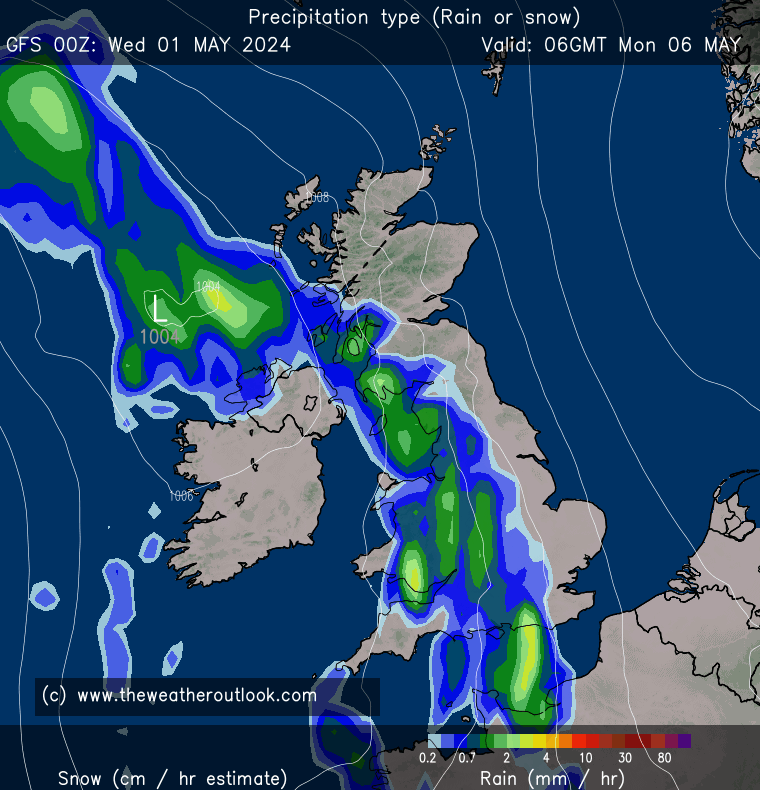

Wales/Cymru Regional Weather Discussion
in Regional
Posted
Sliding Low from the North West could be good if angle and trajectory are favourable. The forecast lows on Sunday / Monday looked a little too North for us to be on the cold Northern side therefore suffering from warm sector air. Ideally we want to see that carried further South by the jet before tracking Easterly putting us firmly on the cold side. If the Atlantic blocking ridge moves a little further West it will put us in the firing line for sliders like this, channel lows or NW steamer opportunities. Hoping for upgrades ahead of next week!