


robt
-
Posts
543 -
Joined
-
Last visited
-
Days Won
2
Content Type
Forums
Blogs
Gallery
Events
Learn About Weather and Meteorology
Community guides
Posts posted by robt
-
-
The most interesting storm at the moment is the one near Paducah, best CAPE down here too - 3000 j/kg on hourly meso just ahead of dryline. Good rain-free base around the meso too.
It appears that Wacky Races have broken out towards Quanauh and Eldorado as everyone goes after it.
-
 1
1
-
-
Theres a storm to the south of the Red River that may be interesting. Just passing Paducah...
-
New Tornado Watch issued..
http://www.spc.noaa.gov/products/md/md0666.html
MESOSCALE DISCUSSION 0666
NWS STORM PREDICTION CENTER NORMAN OK
0341 PM CDT SAT MAY 16 2015
AREAS AFFECTED...CNTRL/ERN TX/OK PANHANDLES...FAR NW AND N
TX...WRN/CNTRL OK
CONCERNING...TORNADO WATCH 175...
VALID 162041Z - 162215Z
THE SEVERE WEATHER THREAT FOR TORNADO WATCH 175 CONTINUES.
SUMMARY...A BROKEN LINE OF INTENSE TSTMS IS PROGRESSING NEWD ACROSS
THE ERN TX PANHANDLE AND NW TX. THE DOWNSHEAR ENVIRONMENT ACROSS OK
IS BECOMING INCREASINGLY FAVORABLE FOR TORNADO POTENTIAL /POSSIBLY
STRONG/. A NEW TORNADO WILL BE ISSUED SOON FOR WRN/CNTRL OK AND
POSSIBLY PARTS OF NORTH TX.
DISCUSSION...A BROKEN LINE OF INTENSE TSTMS WITH A FEW EMBEDDED
SUPERCELLS CONTINUES TO MOVE NEWD ACROSS THE ERN TX PANHANDLE AND
THE ROLLING PLAINS OF NWRN TX...WITH REPORTS RECEIVED RECENTLY OF
LARGE HAIL AND A COUPLE TORNADOES. ADDITIONAL TSTMS ARE DEVELOPING
FARTHER W WITHIN TORNADO WATCH 175...BUT WITH VEERED LOW-LEVEL WINDS
AND A DRIER BOUNDARY-LAYER...LARGE HAIL AND DMGG WINDS WILL BE THE
PRIMARY THREATS.
THE ENVIRONMENT ACROSS WRN/CNTRL OK IS ONLY MARGINALLY TO MODERATELY
UNSTABLE /PER 18Z OUN AND LMN SOUNDINGS/...AND STILL CAPPED WITH A
WARM LAYER NOTED NEAR 1.5 KM AGL. EXTENSIVE CLOUD COVER HAS ALSO
LIMITED DIABATIC HEATING ACROSS CNTRL OK...WITH TEMPERATURES
REMAINING IN THE LOW-MID 70S. DESPITE THESE POTENTIAL LIMITING
FACTORS...LOW-LEVEL SHEAR WILL CONTINUE TO INCREASE INTO THE
EVENING...AND WILL FAVOR THE RISK FOR TORNADOES /SOME POTENTIALLY
STRONG/ ACCOMPANYING DISCRETE SUPERCELLS ACROSS WRN/CNTRL OK AND
POSSIBLY INTO PORTIONS OF N TX. AS A RESULT...A NEW TORNADO WATCH
WILL BE ISSUED SOON.
..ROGERS/DIAL.. 05/16/2015 -
Looks like most are heading to Texola.
-
Basehunters/Nick Drieschman say possible Tornado on the Shamrock cell..
Although, Basehunters have just driven through the RFD on the cell, and not had much.
-
Serious lightning in the tornado warned storm. Kelley Williamsons stream is covering this very well.
Yep.
Nick Drieschman is repositioning pretty close to it.
-
Similar weirdness here,a North-westerly breeze yet still very humid with dewpoints around 17c.
Dewpoint now at 16c, with a really soft breeze blowing. Humidity still above 70%
-
Just under 80% humidity here this morning. Very, very weird feeling to it all.
-
Just had an absolute torrent of rain here, with some lovely deep rumbles of thunder. If I hadn't had a skinful yesterday, I'd be sat in a field somewhere watching this one.
-
Skies up here have clouded over and taken on a really strange hue... Its getting wierd..
-
BINGO!!!! Lightning sighted miles to the north-west of here, just lit up the sky, I suspect around Aylesbury. Anyone over Milton Keynes, Northampton way, keep a lookout!!!
Lightning map says strike to the N of Aylesbury,
-
This is of course the main event getting going right? About midnight-2am or so??
Yes. Probably nearer 4am for me if its still bimbling north.
-
1
-
-
woah... so they abandoned coverage because of the "tornado" ?
They abandoned because of the storm first, then mentioned the other stuff.
-
Can someone in Basildon get a photo of the wall cloud passing over, it's awesome but my wife has nicked my camera!
Mate of mine is out there at the moment, so if he's back in time, I'll nick it.
-
Shelf cloud over Cap Griz Nez (northern France), an hour or so ago..

-
8
-
-
Slightly mental wind strength at Canterbury for the cricket...
-
The skies on Sky Sports 2 are unreal at the cricketIt shows the mothership if I'm not mistaken
Shown a few angles of the edge of it, and its got a serious overhang on it...
-
That sky is unreal on the Kent v Somerset T20 Blast game
Absolutely pitch black to the south, yet still brightish to the north...
-
First time in a very long time that I've been under a Level 2...
-
The one behind it looking like another in france going up too could they join not far behind.
Almost looks like it may 'stall' and transit up the east coast...
-
T20 match live on Sky Sports 2 at Canterbury and you can see the storm approaching. Commentators already said there is a storm closing in.
Gone very dark, very quickly there too.
-
It feels very muggy and very 'staticy' at the moment. When this storm bangs, its going to be big.
-
A couple of intense showers to the north. One over Sheffield, the other bigger one near Leeds. No sferics yet.
Been watching the one to the west of me build for the last hour. Now gone very, very dark that way.
-
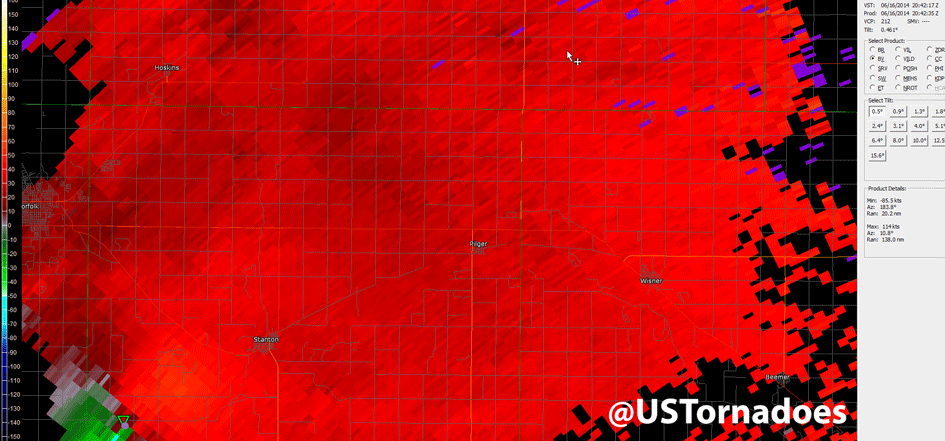
Vorticity loop showing the tornadoes..
http://www.ustornadoes.com/wp-content/uploads/2014/06/20140616_NEtwinTornadoes_radar.gif


Chase Day 10 - Discussion West Texas
in Storm Chase USA
Posted
Tom and Chicken just on Camera...