


shedhead
-
Posts
2,572 -
Joined
-
Last visited
-
Days Won
1
Content Type
Forums
Blogs
Gallery
Events
Learn About Weather and Meteorology
Community guides
Posts posted by shedhead
-
-
- Popular Post
It's done and dusted, very wintry spell is in the bag. even the met office are going with a much colder spell now. I will make this prediction for next week, a bucket load of gold stars for fergieweather and steve, and significant snow, ice, frost & drifting for all of us..thank you to the weather gods for smiling on the long suffering coldies at last.

Hope that post is 'tongue in cheek' Frosty, because otherwise it has 'kiss of death' written right through it....
-
 15
15
-
From here on the term 'battleground Britain' does seem a fair one to use. IF the 06 GFS were to verify as shown some parts of the UK would see shedloads of snow (no pun intended!) from later next week onwards, but equally there could be a lot of rain around at times too for those on the wrong side of a fluctuating boundary.
As far as I'm concerned the most important thing (apart from rain across the next couple of days) is getting the proper cold air in from the NE midweek, because if that happens it will be much more difficult for fronts to push east and we would probably start to see more snow than rain. The alternative is clearly not the kind of Atlantic based set up we saw in Dec, but rather similar to what we are seeing now, with probably more rain than snow.
More runs needed, but for now trend is our friend imo.
-
2
-
-
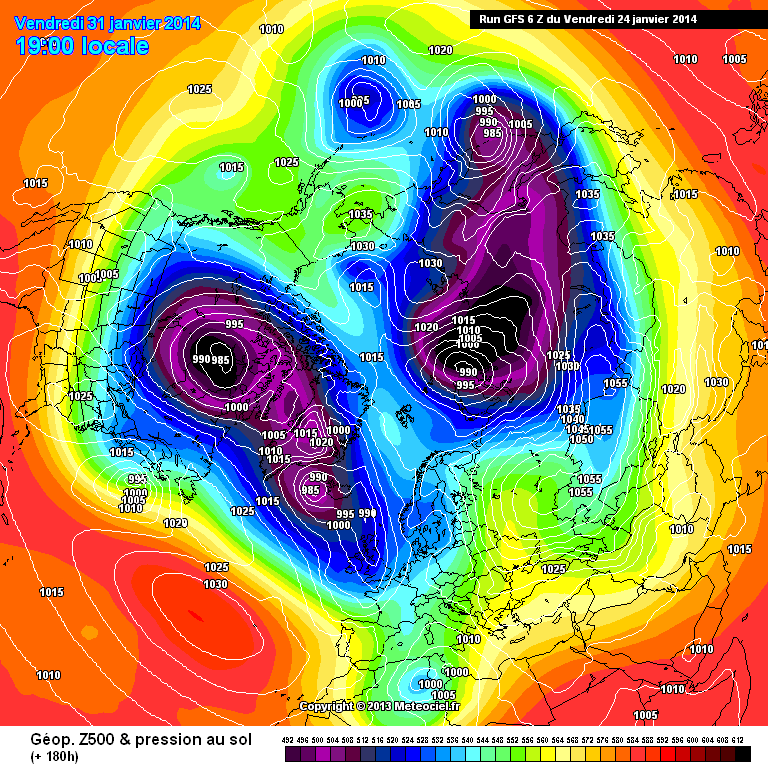
Well If you take the fact the GFS is poor in blocked scenarios, the fact it has a eastward bias , The fact that it models 850's to high to the east, the fact its the 06z then your left with probably the most eastward solution.
http://modeles.meteociel.fr/modeles/gfs/runs/2014012406/gfsnh-0-180.png?6
pretty good there.
Who wants a vitual sportsmans bet that the slider doesn't get east past Ireland......
S
IF the cold gets established as shown midweek, then that will be increasingly likely imo.
-
1
-
-
Given what extended Autumn has delivered so far, it's hard to see how anyone can be disappointed with this T+144hrs, if for no other reason than a dry perspective....
-
4
-
-
- Popular Post
Perhaps its time for a 'new' head, shed.
Consider it done...now watch every model implode across the next 24hrs, with a raging blowtorch for next week....
-
12
-
- Popular Post
Another step in the right direction for cold next week, with the chances of snow having increased quite a bit on the overnight runs, especially across the northern half of the country. No need to look any farther than today to see just how much trouble the models have when trying to bring rain eastwards into a cold block, even one that is centred 1500 miles NE of us, with the MO's forecast from only 12 hours ago pretty much bust as far as timings are concerned.
As of now though rain remains the main concern. Stalling fronts well might be great news if your #1 priority is an increased chance of sleet or wet snow, but areas that do not need the rain could really do with them pushing though as quickly as possible. Hopefully Sundays will be the last one, with Tuesdays diving SE into France....sorry Nick.
Edit-: Having declared my original cold, wintry Feb forecast dead, I would now like to officially reincarnate it...
-
21
-
- Popular Post
Posted Today, 16:32
fergieweather, on 23 Jan 2014 - 16:20, said:
Correct - and I've just come of a conference with UKMO who remain confident on that ultimate outcome (and they aren't expecting any issues re lowland snow across southern England next week, as everything currently sits model-wise, but I think we'd all gathered that from the models ourselves). The rain issues, on the other hand, are top of the agenda. Tomorrow offers e.g. 10-15mm 30%PROB 20mm Somerset Levels; same area Sunday 15-25mm with to 35mm possible locally. EA have raised to Amber there too.
Glenn W
Hmmm.. How does one have high confidence circa 10 days in advance to a return of Zonal & no issues regards lowland snow, but a 30% probability of 10-15mm of rain for the next day?
I would take it with a pinch of salt re snow issues next week, especially amounts/quantities. I can count a lot of times the forecast has been "Little snow" and turned out to be quite a lot.
In view of responses to Ian F's professional input I think we are very lucky indeed that he continues to post in here...some people seem hell bent on arguing with just about anything and everything that doesn't scream snowmamadden...
-
20
-
now that's what I'm talking about!
Can you imagine what this place would be like now given similar synoptics to those? Frosty would have ran out of superlatives ages ago....
-
5
-
-
This is a good point. Battleground scenarios do work best when the cold is already in place, imo. This needs to be factored in when we see charts that have delivered snow in the past - they may not deliver in the same way this time due to lack of cold in situ. Many charts we are seeing at the moment might fall into that category?
Yes, it is a very important factor, if you already have the cold air in place, along with frozen ground and a frigid N Europe the difference is as stark as night and day. If the synoptics across the last week had
been similar to the last week in 79, even what we might see next week would probably have resulted in a significant wintry spell, but with things as they are (and have been) it's all the more vital that we get the proper cold in situ overhead and not just sat c.500 miles to our northeast. Bit like building a house actually, you can have the best building materials money can buy, but if your foundations are crapp then your house probably won't last very long... despite not looking too bad on the face of things.
-
2
-
-
All talk of battleground snow events are a tad premature imo and until we get a cold block in place over us I think thats how they will remain. Here is a classic battleground snow set up for the south way back when, though I remember it well, it was a rip snorter...
-
2
-
-
Looking at the 06 ENS the Op never really drifts far from the mean within the high res and even in the low res part of the run most members band between about -5c and +2c. Therefore any suggestion of potential huge variations in possible outcomes for early Feb are not really franked here.
-
1
-
-
But it is still valid model discussion.
As is everything else within the model suite, but that tends to get forgotten, however often Paul or any other mods make the point.
On that note, IF the 06 is correct it does't look like we have much of a gap early next week before the next lump of rain comes crashing in off of the Atlantic....whether it can come in at a more favourable angle to give some snow away from northern hills remains to be seen.
-
Impossible to be prescriptive. Even next week is tricky enough and no-one at UKMO will discount more wintry possibility given ongoing variance in model handling of low track/shape, entrainment of colder air etc. But that is still a few days away, so not a pressing forecast issue.
Thanks Ian...I'm sure you can understand the on going concerns here and why chasing a few wet snowflakes around 5 or 6 days hence is not exactly the main priority. Frankly I'd settled for a strong, dry cold E'erly that would just hoover the moisture out the ground but not freeze it...that however still looks like a hope rather than an expectation for now. Cheers again.
-
2
-
-
Nope.UKMO assessment on 00z suites as previous. Snow NE especially Tues-Thurs etc; perhaps spell of snow W/NW later in week as westerly mobility returns. Low confidence on detail/timing with marked entropy spike d8-9. Thereafter high confidence on return to broadly zonal pattern "as seen so far this winter" albeit with around 10% EPS/MOGREPS showing varied interruptions through deep lows etc, some with easterly components. Anyway, detail Tues-Sat trickiest but UKMO not currently concerned re major snow threat for e.g. southern England (but it is too far away anyway to be given much detailed attention). In any case, all their focus on disruptive weather is tomorrow and Sunday, understandably.
Oh dear, does that possible return to a zonal pattern carry the same level of rain risk down here Ian, or does it want to lift the bigger totals farther north and give us some Azores ridging?
-
ecm ens pattern is firming up on a continuation of the status quo. canadian vortex, alsakan ridge, scandi ridge, azores high which waxes and wanes with the next system that comes off the eastern seaboard in association with another burst from the vortex. the systems traversing the ridge and dropping into europe. each episode begins with the ens mean progging the track east of the uk and this then corrects slowly west so that the anomolys drop through the uk. we now see next week agreed upon and although the ops seemed to want to drive the jet ne, the ens are firming up on the next trough dropping in and the ops slowly catching on. so next weeks set up likely to be broadly repeated days 9 through 12. interestingly, the anomoly to follow this one seems to be able to come in on a flatter trajectory (not iceland se towards us) as the atlantic ridge seems to back west somewhat. should the same corrections apply due to the blocking being stronger we may well see some more obvious battleground charts cropping up soon in week 2.
Agree, still looks like the best we can hope for at this stage, but unfortuantely this kind of set up could well worsen the prospects for further flooding in this neck of the woods, as Atlantic fronts become slow moving and maybe even stall. However at this stage any stalling looks most likely to occur farther eastwards.
-
Hi Im not a regular poster, but as the jet dives south right over the U.K, wouldn't that aid in the diversion of low pressure south under any block to the east? Thanks in advance
In the ideal world you want it diving SE'wards to the SW if us, but not so far as to keep the LP's out of range.
-
It does look as though any return to the 'Atlantic train' will be heavily influenced by the blocking to our north/northeast, which opens up the possibility of some major snowfalls, either through February '96 style trough disruption or through Arctic sourced northwesterlies. Either way, I don't see an easy route to anything especially 'mild' in the medium term even if we can't quite manage a full blown easterly. This is obviously more promising the further north you are (although far from exclusively so and the outlook could shift the pattern further south), and isn't good news for those affected by flooding as any big marginal snowfall events are likely to only make matters worse for low lying areas.
Exactly LS...most of us realise that the return of the Atlantic or the dominance of the Atlantic does not mean there will be no wintry weather, in fact all the heaviest snowfalls in the UK occur when the Atlantic tries to make inroads into a cold block. That to me looks the most likely set up now going forward, it's all about where that boundry lies as regards to who gets snow and who gets rain. However as far as sustained cold is concerned. i.e the kind of cold provided by a long drawn E'erly, I think that remains the rank outsider.
-
5
-
-
Looking at that alone though how likely is it to be right at this time frame? The 06z is so progressive that's what it's famous for , so if it struggles with things inside the 100hr time frame how much more so is it likely to struggle after t144?
The models are slowly getting to grips with a pattern change and expect more flip flopping over the coming runs , the Russian high is an absolute beast , if the gfs was right a week ago we would have swept the Russian high aside as soon as it made its first appearance .
All in all a very big step this morning toward cold and snow , that's not dressing anything up , its how it is .
Well the ECM also has another system bowling towards UK at the same time, on what looks to be a flattening and increasingly powerful Jet, so for now it looks rather more likely than not to me I'm afraid. Until I see something sustained that suggests the contrary I'm going to stick with it.
-
1
-
-
I think Gibby's post was balanced enough. By T+144 the latest UKMO assessment (just issued) has concerns re snow in NE/E Scotland but not elsewhere. Shannon Entropy highest d9 re timing of broadly zonal return (but confidence fairly high re latter eventually). Into 10-15d trend, broadly westerly mobility expected but ca 10% EC EPS & MOGREPS solutions showing periodic easterlies. Further trend update expected around 1130am.
Any more thoughs on Sunday's event Ian and do UKMO have concerns further down the line re rainfall, because regrettably it looks as though the Atlantic train is going to keep rolling.
-
Jet looks set to power up significantly on this run, so IF correct there looks a real danger that the Atlantic could come crashing on through later next week. Any sort of sustained cold looks very unlikely based on this.
-
4
-
-
On a positive note the 06 suggests the block will remain weak enough and sufficiently far east to allow the rain on Sunday to clear through rather than stall...hope that evolution continues to be supported on subsequent runs, but it must be said totals across the SW do look worryingly high.
-
1
-
-
This is what you call proper winter, not the crud we get 95% of the time.
-
Once again this morning things remain very finely balanced, but unlike yesterday when the overall trend was towards milder conditions, this morning that trend is towards colder. However, whether we are any closer to nailing any one particular set up remains a mute point. On the face of it the consistancy shown by UKMO in the 120-144hr range is encouraging, but after what Ian said yesterday about Exeter's thoughts on their own model in the longer term it's probably wise to see if he has similar things to report today.
In my opinion it's events across the coming weekend that should still hold center stage for now though, because the potential is certainly there for places in this part of the world to see some very serious flooding....to add to the already very serious flooding that simply refuses to go away.
-
4
-
-
As of a few minutes ago (!) the consensus opinion from UKMO colleagues does remain one of Atlantic superiority returning at some stage next week (intense cold leaking ad-infinitum from Canada ensures that likelihood), but we shall see.
Hardly a surprise really Ian given what you have been saying consistently for several days, along with the fact not one model suggests anything other than a return to Atlantic dominance once the briefest of brief cold NE'erly shot is over next week - that's if at actually appears at all.
It looks increasingly likely to me that any snow will come from between W and N around the turn of the month, rather than from between N and E, indeed hoping the block will get boosted by the Arctic high and extend sufficiently west to put us in the freezer appears increasingly forlorn imo....which is very annoying because it pretty much destroys my cold late Winter forecast
-
2
-


Model Output Discussion 19th January 2014-18z onwards.
in Forecast Model Discussion
Posted
Let's try to remember there is room for all views in here and certainly no need for name calling....agree re it being something that I'm coming on board, but I still have one foot on the harbour wall for now too..