


shedhead
-
Posts
2,572 -
Joined
-
Last visited
-
Days Won
1
Content Type
Forums
Blogs
Gallery
Events
Learn About Weather and Meteorology
Community guides
Posts posted by shedhead
-
-
But what if the zonal express is replaced by a Bartlett high? Coldies worst nightmare. However, I agree with those who think the outlook is more encouraging from a cold perspective than at any stage of this woeful winter so far.
That would have to be weighed up against the prospect of further very wet weather though Frosty IF the cold fails to deliver. At least a Bartlett would mean a lot more drier weather for the exceptionally soggy south, so I guess given the option of that or a repeat of Dec most would now choose the former...especially those with a high tide mark half way up their living room wall!!
-
 2
2
-
-
ECM op is from the progressive side of the ens this morning with the trough disruption just a bit far ne but still ne UK looks open to wintry conditions next week.
Note that whist the x model T96-T192 period looks difficult, the days 9/10 charts seem to be settling on the strong jet streak taking the depression through (at what track unknown). The polar profile then dictates what follows and it could be very wintry if the current trend continues. not surprised by some of the posts this morning but you need to stand back a bit and look at th NH as well as Atlantic.
You are rapidly becoming the new Frosty ba...
 Agree though that if there has ever been a time during this extended Autumn to step back and look at the bigger picture, then this is it. On the face of it the charts still look far from inspiring within 1500 miles of the UK, but towards months end the Arctic pattern is being progged to undergo significant changes, which are not ones that will takes weeks to make themselves felt across the UK. Said in the Moans thread yesterday that the next week to 10 day represents the pivitol point for the rest of Winter and this morning I'm again rather more encouraged that things will fall on the right side of the fence.
 -
3
-
-
I think we are now closing in on a tipping point across the next 7-10 days, which will dictate the direction of travel for the remainder of what has so far been nothing more that extended Autumn.
Personally I do not see any kind of half way house here, we are either going back to an Atlantic pattern, albeit not as vigorous as December's, or the block is going to win out and give us a much colder and at times wintry Feb.
Up until recently and since late Oct in fact I've been firmly in the latter option camp, now I'm probably 70-30 in favour of the former, but imo we do not have long to wait now for this to be settled.
-
Rather depressingly today is day one of the second half of official Winter and it finds most of us still awaiting the first snowflake and some of us even still awaiting the first air frost, so I guess the glass half full view must be that things can only get better...hopefully.
As Nick F's excellent post said however prospects for the next week or so and perhaps even the remainder or Jan do not look encouraging as far a deep cold is concerned, with only enough minor changes in the overall pattern to slow and weaken the hiterto raging Atlantic train, rather than fully derail it. GFS does again look rather to progressive with it's return to a flatter pattern next week, but using recent longer term charts as a guide ECM could again be introducing to much amplification to the pattern, with something of a half way house blend probably being how things will end up later next week.
Beyond that we are getting dangerously close to the start of Feb and the last third of official winter, so we really do need to see some tangible signs of a proper and sustainable pattern change across the next couple of weeks if winter 2013/2014 is not to be remembered for all the wrong reasons...well at least as far as this place is concerned!
-
1
-
-
The horror show just gets worse and worse. Yesterday I had to walk to work in rank 2C cold rain. Today I was blasted by drizzle and a vile S.E. wind and there's still barely any signs of it actually getting light due to the driving drizzle and gloom. Truly the worst winter weather anywhere on the planet. It's soul destroying
Had a good snowfall on 19th Jan 1998 so non-winter 2013/14 will soon surpass that as the worst start to a winter I can remember. A desperately poor season. 13 hours below freezing in almost 6 weeks and can't even get the 2 day northerlies that were common in the 90s. It's not even as if there's been any real mild weather. None of the foehn effects that were common in the late 80s and 90s just a ridiculously narrow range of temperature and pathetically low diurnal ranges. One insipid day blending into another with nothing to differentiate. Nothing to go out and photograph. About the most pitifully boring and uninteresting season I've experienced
Top quality ranting....
-
2
-
-
So here we are again with differences between GFS and ECM with regards to the upper flow post t+168, ECM amplifies the flow upstream over the N Atlantic - which allow the trough over western Europe to disrupt into a cut off low with pressure/height rises to the north, GFS keeps the upper flow flat and thus no disruption.
The ECM disruption brings the Scandi block back into the frame, which may help block further attempts at the Atlantic regaining a foothold. But the crucial period for potential disruption T+168 and after, so more runs needed to see if ECM has picked up on something. Certainly wouldn't throw the towel in just yet in defeat to the Atlantic, but it's becoming a rather long-drawn out affair this east vs west battle!
Agreed Nick, but let's face it it's rarely any different.
Looking at the T+168hr from GFS, it's not hard to see how with some fairly minor changes the latter part of it's high res run could have ended up looking far more ECM like...the trouble is the same could pretty much be said about the opposite. To my mind the most important thing is to get the block in place first, at which point modelling it's future evolution should become a bit easier and more consistent....perhaps with a few welcome surprises too.
-
5
-
-
http://www.wetterzentrale.de/pics/Recm1681.gifIf only the ECM was right, we 'd get an easterly in a week... (Uppers aren't much but hey!)
Wouldn't mind a tenner for every time I'd heard or seen this said GP. Easterlies modelled post T+144hrs probably fail to materialise 9 times out of 10, so whilst it's encouraging to see ECM has not given up completely on the idea I think it's prudent to assume it won't happen at this stage. That said we are now entering a period where the synoptics will be much more favourable than they have been all winter for this type of set up to develop, with what look like small short term changes possibly resulting in large term implication farther down the line, so if nothing else we do at least now have some interest/potential.
-
4
-
-
I spent a fair amount of time in Arctic Norway and I can tell you the experience of seeing an active Winter cold front go through is on another level to here.
On many occasions I witnessed a 10c drop of temps inside 30 mins, but the most noticeable ones were close 15c, which meant you could literally watch ice
forming on the puddles in the snow. On one or two occasions I saw all rain turn to all snow in a matter of seconds, a process that can take several hours to
complete here at times....now that's proper weather which incidently most often occurred in their mildest winters.
-
1
-
-
The "people shouldn't wish for x type of weather" argument really grates on me. The weather will do as it pleases. If we all stopped wishing for our favourite types of weather because someone else is inconvenienced by it, we'd all have to be thoroughly miserable through every type of weather.
There is nothing wrong with hoping for a certain kind of weather.
Absolutely right, I and I bet everyone else in this forum has wished/hoped for a certain type of weather at some stage, as will most of the population have. We all know we can't control it, but there would be something a bit odd if for instance you set off for a weeks summer holiday in Newquay with your kids and didn't hope it would be dry...if for no other reason than rain = £££!
Wish for what you like, but don't think wishing hard enough will make something happen...we see that daily in the MDT and it ain't happened yet...
-
cheeky_monkey, on 10 Jan 2014 - 14:11, said:
Its not an opinion its a fact...as is having lots of rain and wind..both as bad as each other
Cheese
Clearly it isn't a fact, so I shan't waste my time debating something so ridiculous with you.
The fact is any particular weather type can become a pain if you are stuck in it for an inordinate amount of time. I love dry, hot and sunny summer weather, but a fortnight of that on the bounce and I'd be looking to see a change. I think a good variety of weather is always welcome, but unfortunately compared to Alberta our weather is pretty much boring full stop.
-
a realistic look at the various types of model output this morning to 240h-are they consistent, has too much been hoped for rather than realism?
read my pdf
A good, informative read John, which puts the goalposts exactly where they should be...for now.
Turning colder yes (to be fair It couldn't really become much milder), some if not a fair amount of optimism for cold eventually developing from much more promising synoptis than seen thus far all winter, but nothing currently to suggest the kind of more extreme senarios recently modelled will come to fruition any time soon. In other words...pretty much where we've actually been for several days now.
-
2
-
-
I think the root of this poor output seems to stem from the less than favourable movement of the block to our N and eventually NE. It starts off around Spitsbergen, drifts south into the GIN corridor, which is a good position, then drifts SE into NE Europe - which then allows low pressure to drop too far north just to our west, which leaves us in a not so cold SE flow from southern Europe.
Would want to see the Atlantic troughing disrupt into a cut-off low across SW Europe quicker than shown on GFS and ECM, by which time it's too late with any easterly, as the deep cold pool is out of reach to tap into. Ideally need to see more amplification in the upper flow upstream over the NW Atlantic for a quicker trough disruption. Still chance that the models aren't handling the block too well and we may also get better amplification upstream to disrupt Atlantic troughing to allow height rises to our north. But for now, a pretty somber reflection of the models.
Agree Nick - it's easy to see where this appears to be going wrong as far as getting cold in UK, but exactly why it's going wrong is rather more difficult to nail down. The devil really does look to be in the detail here and as ever that will continue to chop and change, but for now I still think it wise just to focus on the fact all the big 3 build pressure solidly to our northeast by 120hrs....again that will do for now imho
ECM
GFS
UKMO
-
1
-
-
Fair to say the 12 GFS has all appeal of a pound of chillies in your boxers, but UKMO is still half decent to say the least at 144hrs, with the potential to develop into something cold if it went to 168-192hrs.
For now though all eyes turn to ECM, will it be Bollinger or Boddingtons? We don't have long til we find out.
-
4
-
-
It's frustrating but to be honest I was expecting this go the way of the pear, yes we have a strong block to our NE and lowering heights over the Med but we still need heights to build towards Greenland for anything sustained and for that we have to rely on a SSW, which may or may not happen and even if it does we still need some luck for it to fall into a favourable position.
The 144hr I posted shows decent ridging into Eastern Greeny at 144hrs, so IF that happens as shown I think there is more than a fair chance of some proper cold synoptics farther down the line. You know how difficult it is to get an Easterly set up and that difficulty is shared by the models in trying to nail the evolution of one, so expect there to be much more chopping and changing of the detail...as the last 24hrs has seen. However the big picture remains pretty much the same, so until that changes (as well it might) I wouldn't write anything off.
-
Lol, we've just wasted 72 hours of chasing phantom easterlies, again. Looks like the MetO cautionary approach was fully justified with the majority of the UK just seeing a colder but still a wet week and then the prospects of more unsettled but milder weather. Roll on spring!
Come on SI, most unlike you to throw the metaphorical towel into the ring. Just think where we were this time last week, with the only chance of snow being on the summit of Ben Nevis for 10 mins overnight. The first bite at the cold cherry always looked to be a bit iffy, but at least it's going to turn colder and the pattern at T+144hrs is more than acceptable if we're prepared to be a little more patient.
And yes before anyone asks...I am feeling OK
-
6
-
-
I agree 100% It is a bit dissapointing that yesterday we were taling about snow for early next week, now it is the end of next week. Often we see cold spells getting pushed back and the longevity shortened until all we get is a few sleety showers on the east coast. Singers crossed this cold spell wont take that oath but you never know!
Indeed Tim, you only have to think back to the northerly that never was in late November for a perfect example. What looked like providing a widespread snow event for the north and even some wintryness for the south only 3 or 4 days prior ended up as a few sleet showers in Shetland, so we have to remain guarded. Looking at the latest T+144hr though (which is still as far ahead as I feel it's prudent to look) the overall pattern still looks pretty good for cold imo, with the Scandi HP ridging west into Greenland...that will do for now.
-
4
-
-
06a delivers in the end. By next Sunday the block has orientated sufficiently to give a NE flow under -8c uppers giving widespread snow showers to most. looks like the PV to our north is strong enough to evebtualy topple the block though unfortunately. If we had seen this run 3 weeks ago though we would be jumping for joy!
Not singling you out in any way here Tim, but how often do we see this type of post in this type of situation? What we definately do not want to see here is any really good synopotics flatly refusing to come inside T+144hrs, because when that kind of trend develops it tends to lock itself in, so as others have said the coming 24-36hrs looks pivotal in deciding what kind of bite this first cherry of Winter gets.
-
1
-
-
has anyone else noticed the issue with the 00z ensembles (GFS), certainly the operational doesn't tie in?
If you look closely at the Op line it splits into 2 at 00hrs on 15th.
-
Can I ask, I see quite a lot of people showing the GEM model over the past few days. Whereas only a month ago it was ECM, GFS and MET that people looked at. Has the GEM become a lot better recently or is it just showing what people want to see? Serious question.
I think it's a bit of both to be honest, but to my mind the GEM is not consistently good enough despite appearing extremely good from time to time - the difficulty is picking out those 'extremerly good phases, which is one of the main reasons why I only give it a cursory glance each run.
-
1
-
-
Couple of points from 00Zs:
1. Uppers not quite as important when the feed is off the continent (though snow cover over low countries would be handy)
2. Small changes to model output will decide whether it snows or not in any location. While the charts look like they do this morning, no-one (north or south) will have any great confidence in whether they will see snow or not until T72. Quite frankly, at the moment it doesn't really matter whether the charts say snow over your house or 300 miles away - they will probably show something different tomorrow!
More like in another 90 mins...
-
2
-
-
'It's all relative' seems the most apt term this morning, because whilst the overall sense of disappointment is understandable, I don't think one of us would have refused the overnight runs this time last week. What we've seen slowly develop across the last 24hrs is nothing more than an adjustment to the original signal, the overall pattern going forward remains largely unchanged, but it does perfectly highlight just how the MO and this forurm handle potential cold spells post T +144hrs in diametrically opposing ways.
-
2
-
-
just follow the 1010mb isobar to see where the air has actually originated from?
Fair point JH, not saying this is coming right off the Steppes quite yet, but I'd rather have air sourced from the Balkans than Barbados that's for sure..
-
1
-
-
HMMMM Reverse zonality http://www.wetterzentrale.de/pics/Rtavn1801.png!! Almost has a look of 47 about it!!
I did a similar exercise last week, but perhaps worth repeating. It all happen in a week or so then and it may well do the same now.
16th Jan 47
24th Jan 47
Today
16th Jan 14
-
Yes the Tim henman of models is there now...
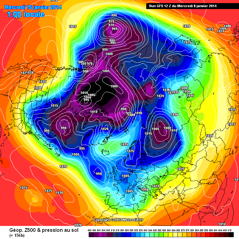
T156 the train is coming
Heights down to 532 from 540 indicating greater instability
http://modeles.meteociel.fr/modeles/gfs/runs/2014010812/gfsnh-0-156.png?12
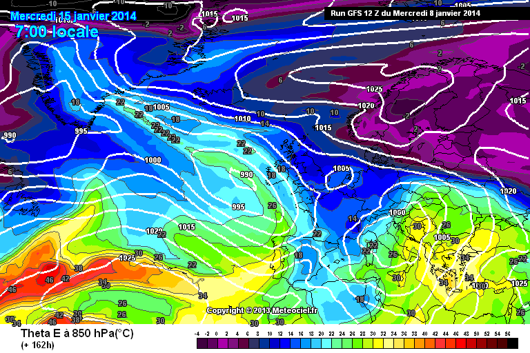
Theta E chart down to 12c
http://modeles.meteociel.fr/modeles/gfs/runs/2014010812/gfs-6-162.png?12
& the atlantic approaching...
S
It's starting to look rather more Djokovic imo...with a bit of Federer thrown in too....
January 15th will be 2 days, both the 1st and 46th day of winter!

 Agree though that if there has ever been a time during this extended Autumn to step back and look at the bigger picture, then this is it. On the face of it the charts still look far from inspiring within 1500 miles of the UK, but towards months end the Arctic pattern is being progged to undergo significant changes, which are not ones that will takes weeks to make themselves felt across the UK. Said in the Moans thread yesterday that the next week to 10 day represents the pivitol point for the rest of Winter and this morning I'm again rather more encouraged that things will fall on the right side of the fence.


Model Output Discussion - 10th Jan Onwards
in Forecast Model Discussion
Posted
Indeed, NAVGEM is significantly quicker in building heights towards the Pole and although it's not a hugely consistent model (tho better than when it was NOGAPS) it does show just how quickly things can change way ooooop N.