ChezWeather
-
Posts
1,972 -
Joined
-
Last visited
-
Days Won
1
Content Type
Forums
Blogs
Gallery
Events
Learn About Weather and Meteorology
Community guides
Everything posted by ChezWeather
-
Have faith people! Its heading this way, the general direction is SW but the eastern edge is filling out with more precip
-

The Midlands Regional Weather Discussion 19/01/2018 Onwards
ChezWeather replied to BlueHedgehog074's topic in Regional
It is, the met office precip graphic is indeed a prediction, however it highlights the chance that this low could expand into a much larger area of precipitation I could have probably worded that post a little better -
The Midlands Regional Weather Discussion 19/01/2018 Onwards
ChezWeather replied to BlueHedgehog074's topic in Regional
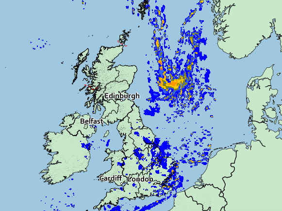
Theres more to this low that what we can currently see on radar (Met Office Precip vs NW radar) -
Theres more to this low that what we can currently see on radar (Met Office Precip vs NW radar)

-
Forecasts & Precip charts go out of the window now folks, its time for some good old radar watching, see you all on the other side, hopefully with some snow
-
Im guilty of it myself, but we shouldn't really be comparing things to Mega events such as 2010 where large parts of the region had almost 2ft of snow, even 2013 was something special in regards to how much snow actually fell
-
Well tonights 18z run will be the one to watch regarding tomorrow morning, hopefully that large mass of precip is shifted slightly eastwards
-
Amber Warning now updated, shifted North and West, includes S Yorks and the Peak District
-
Netweathers radar is by far the best avaliable
-
Dont write it off yet, plenty of time for the models to change, and as we know, snow events are notoriously difficult to pinpoint.
-
Lets hope it snowballs in size and blankets the entire region
-
Well would you believe it, latest MetO prediction sends the heavyiest area of Precip over the North West tomorrow morning, completely missing most South Yorks and most of West Yorks We need it to be shifted back east!
-
High likelihood of the Amber warning being chopped and changed over the next 24 hours, im hoping these showers can hold off tomorrow, id like to make it into work at least one day this week!
-
Well, the latest GFS precip charts are just incredible for this part of the world
-
Tuesday morning now looking very interesting
-
The Midlands Regional Weather Discussion 19/01/2018 Onwards
ChezWeather replied to BlueHedgehog074's topic in Regional
EURO4 for mid-day on Monday -
EURO4 for mid-day on Monday
-
The Midlands Regional Weather Discussion 19/01/2018 Onwards
ChezWeather replied to BlueHedgehog074's topic in Regional
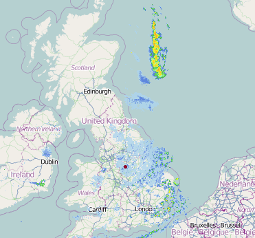
Posted these same pictures a few pages back, but this radar shot from the archives shows the aforementioned Wash streamer you speak of, and the biblical amount of snow that it dropped here. My memory of March 2013 is foggy, probably because id just turned 18 but that picture you have posted is incredible, where was this if you dont mind me asking? I now have to commute to Matlock every day so next week should be fun!
-
Model output discussion - here comes the beast!
ChezWeather replied to Paul's topic in Forecast Model Discussion
Don't take any precip accumulation chart as gospel at this range, they are all likely to be well off, wait until Sunday when the EURO4 comes into play -
Looks like we are in a good spot for this one, harps back to 2010!
-
The Midlands Regional Weather Discussion 19/01/2018 Onwards
ChezWeather replied to BlueHedgehog074's topic in Regional
We should be in a favourable spot for some decent snow next week, looking at similar events of recent times (2010, 2013) Gotta remember that those lot down south see snow alot less than even our region does, and its not all that common here -
Model output discussion - winter proper underway
ChezWeather replied to Paul's topic in Forecast Model Discussion
As much as im sure most of us would love a 62/63 style freeze for the next 3 months its highly unlikely to happen, mild spells will occur and the Atlantic will always be trying to knock at the door, but theres plenty of time yet for the cold to return this winter. In the short term, some very cold temperatures over the next couple of days especially Tuesday -
None of the models picked this up, its developed out of nowhere Id be interested to know the reason why
-
Well guys, this shows how un-predictable these kinds of events are
-
Radar looking good, heavy snow falling here, some-what un-foretasted as well which is always nice and just shows how difficult it is the predict how snow events will unfold