


TheBigFreeze
-
Posts
171 -
Joined
-
Last visited
Content Type
Forums
Blogs
Gallery
Events
Learn About Weather and Meteorology
Community guides
Posts posted by TheBigFreeze
-
-
as we get closer, the downgrades continue. maybe best not to expect too much from tomorrow and then wait for tues/wed when the air will be cold enough to support anything falling from the sky being white. the further north and east in the area the best chance to get a decent covering but then i wonder how much there will actually be on this second front and how quickly it will go through. (i'm ignoring the first one now - it seems to be nothing more than a flurry maker)
This is what I was thinking/saying earlier....that first front weakens so much but might still give a dusting for Norfolk/cambridgeshire, with the fun starting about 11a.m BUT that second front could move through in about 6 hours?? a few showers for Tuesday, but Wed/Thu we could see some heavy connective showers?? what do you think?
-
Take a look at post 569 in the SW regional thread, Ian F has very kindly given us a chart from Exeter regarding Thursday.

just grabbed this from the main model thread.....i'm no expert, but this is looking good for our region isn't it? That is a chart that Ian Ferguson posted in the SW thread
-
read in the model forum that the front could be moving faster than expected so that snow could be here sooner than expected!
-
The region is covered from about 11 a.m, this would possibly be falling on top of slight accumulations from the 1st front which weakens as it passes us
-
just watched the live BBC forecast on the Andrew Marr show and........BBC all is forgiven lol, it showed a little snow possibly overnight, but the whole of east anglia is in a white out from 12 p.m onward
-
As much as I love snow...i'm in two minds as to how much I want, I have a small holding about 10 miles from my home, all the roads are winding back roads in an area that acts like a snow trap when we see snow, could make it very difficult getting there to feed the animals
actually stuff it....give me snowmageddon and i'll borrow the father-in-laws 4x4
1mm? That's nothing isn't it?
isn't 1mm of precipitation = to 1cm of snow??
-
East of England
Days 1 to 5
- Regional forecast
Day 1 to 5 - UK forecast
Day 1 to 5 - UK forecast
Day 6 to 30
Headline:
Bright but very cold. Wintry showers in Norfolk.
Today:
Some bright or sunny spells but staying cold after a widespread frost early on, and with some wintry showers likely, particularly across parts of Norfolk. Maximum Temperature 2 °C.
Tonight:
Staying very cold. Gradually clouding over with snow spreading from the northwest to all parts. This will lead to some accumulations, especially later, also some very icy conditions. Minimum Temperature -3 °C.
Monday:
Cloudy and very cold, the early snow clearing for a time, but then further snow arriving during the afternoon. Some accumulations and remaining icy in places. Maximum Temperature 1 °C.
Outlook for Tuesday to Thursday:
Tuesday, very cold, bright or sunny intervals and snow showers, some possibly heavy near coasts. Wednesday and Thursday, very cold with a biting northeasterly wind and heavy snow showers.
Issued at: 0400 on Sun 13 Jan 2013
Meto appear to have some snow for tonight, but the main snow event will be Wed into Thursday
- Regional forecast
-
could someone explain why so many people say "ignore the BBC's forecast" when if you consider that is probably one of the main sources of weather information for a majority of the UK....wouldn't you expect that to be one of the most accurate?
-
hope no one watched the 04:00 bbc weather forecast....it would become mightily depressive for snow lovers...they have the snow totally miss us, well especially Norfolk, Suffolk...lets hope that they haven't got a scooby and are way off the mark!!!
-
Evening all and hi to the Norfolk(s)! I live in one of those zones that's too far inland for coastal snow and too close to the coast for inland snow. I'm hoping this event will cover both bases. Well a man can dream!
i'm about 20 miles west of you, and sometimes it's like a snow trap here, others...a snow repellant lol
-
shouts!!!!! and listens to the echo, echo, echo, echo
-
For the more southerly easterns.....
so where do us Norfolkians go to discuss the weather please?
-
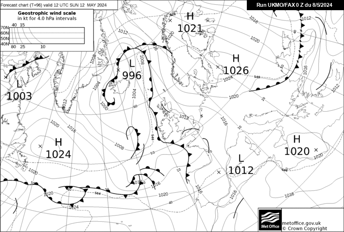
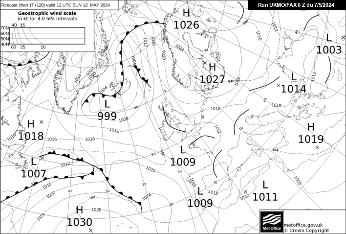
are these the latest fax charts John?
-
I disagree Chris. GFS looks very snowy from midnight sunday through to the early hours of Tues morning
Sorry, but what are you talking about ?
I must be looking at a different set of charts.
with this forum section covering such a large area I think it depends where you live to how good / bad this run is
-
GFS 18z has snow over the majority of Norfolk for most of Tuesday as well
-
I've just signed up for the radar...love it so far...even more when it eventually [hopefully] shows epic snow heading my way lol
-
so what should the dewpoint be to have the best chance of snow?
-
Do you mean the model run or in a text update?
The 5 day forecast
-
Paul- you know sleet was a wind up-
the chance of sleet is currently along a line west of london curve sse away down to west sussex where the slightly milder air bends on the curvature of the isolines-
essex / suffolk all fine, kent fine, surrey/hampshire/west london etc possibly borderline
S
Norfolk??
-
meto 17:00 update is now showing increased snow across Mon,Tue & Wed
-
http://www.netweather.tv/index.cgi?action=10day;sess=
what data do they use to compile these forecasts?
-
current temp 1 degree. dewpoint -2 [is that good?]
-
dose of reality
I'd take this
-
As someone pointed out earlier, the BBC TV forecasts are saying the first front will be too weak, and the second front will fall as rain/sleet in our region..
I will bl**dy spit Frisbee's if that happens!! lol


East Anglia & Three Counties Regional Discussion
in Regional
Posted · Edited by TheBigFreeze