


manutdmatt1986
-
Posts
500 -
Joined
-
Last visited
Content Type
Forums
Blogs
Gallery
Events
Learn About Weather and Meteorology
Community guides
Posts posted by manutdmatt1986
-
-
Maybe they've changed their thinking since my chat with them last night. Will hear Chief's thoughts in hour. Anyway: weather will do what weather will do! Joys of forecasting such stuff on our little insular nation!!
Not much joy if I end up with rain whilst all other eastern and central areas (including my home town in London) get a good dumping of snow, haha!
Thanks, Ian.
Do you have a link?
-
Looks like it's been modelled incorrectly to rise hence why some forecasts showing raw data have it as rain.
The latest BBC video forecasts also have it as rain to the south of London on their graphics.
-
It can't be though as they have manually written that it will turn to rain in their warnings and forecasts. If they thought it was an error then they wouldn't have amended their forecast surely?
Maybe that's just because there's a bit of uncertainty? I don't know, I'm confused.
-
Yes. It's an anomalous rise in WBFL: UKMO-GM had same issue yesterday for same time and area and was manually amended.
So are you saying you are currently expecting rain south of London, Ian?
-
Quote from UKMO for Monday: An area of sleet and snow will come eastwards across England during the early morning, probably becoming light and patchy later in the morning as it slows down over eastern areas. However, later in the day it is expected to intensify again, at the same time turning back to rain in places. Through the day there is the risk of 5 cm accumulations in places, and more than that above 200 m. However, there is greater than average uncertainty at this range, especially in the extent to which snow affects southern counties, and it is quite possible that the Alert will be upgraded to an amber Warning if confidence increases.
I suspect that caveat is more to do with the fronts stalling. At the moment the suggestion is that the second front will slow/stall in the SE ( and linger on Tuesday in the far SE). However the first front is being modelled to be less of an event for the south, stalling north of this area. Probably will not know till Sunday afternoon. These snow events can upgrade or downgrade very quickly. The closer you are to the coast the less likely for lying snow I would have thought.
liamdutton
Still uncertainty about Monday's snow, but Scotland, central, N'ern & E'ern Eng most at risk. 3-7cm low levels, more hills. #uksnow #c4news
A recent tweet again highlighting uncertainty for south/SE.
There seems to be a warm sector on the second low which looks like hitting areas to the south of London, potentially ruining what would otherwise be a good snow event for me.
-
I've noticed that the GFS has consistently shown Monday's snow to change to rain for a time to the south of London only to then turn back to snow. Does anyone know why this might be?
-
Snow for Wales and the South West Tuesday morning?
-
Just catching up with the posts and I have to laugh at a comment in the previous thread saying the latest NAE is a damp squid for the SE. Talk about not looking at the charts properly.
The main core of precip hasn't even reached the SE at +48 and remains across the spine of England.
http://expert-images...011406_1206.gif
As the front is moving SE the 12Z NAE at +48 will illustrate my point.
Just add if the 06Z is similar to the 0Z with regards to prolonging this cold spell then thats a very good omen as I shall explain later.
I think the band of precipitation showing up on the NAE is a very weak dying frontal system that probably won't even reach the South East. A second, much more active frontal system then follows on behind.
Edit. I think that's kind of what you were saying?
-
Latest NAE update is out to 42 hours and has -8 to -10 uppers over London, the South East and East Anglia, -7's over the Midlands and central southern england, and -5's over Wales.
Should make Monday's snowfall less marginal and perhaps more widespread.
Sorry, I don't know how to post a link to it.
-
I've always loved that CFS Model!!

Shows the building of a Scandinavian High instead of the high collapsing over us. It then retrogresses the heigh toward Greenland.
Another possible development further down the line and not beyond the realms of possibility. That is way way into FI though ofcourse.
-
Latest NAE appears to bring Mondays even forward... Half the uk under the front by sun eve? http://www.weatheron...=0&WMO=&PERIOD=
Another snow even yawn lol. http://www.meteociel...&ech=162&mode=2
The NAE could be showing the first, weaker front infront of the more active front?
-
http://www.knmi.nl/e...agse/index.html
Just a quick one before the 18z-
You will note where the PPN spike is on the OP run for mondays snow- indicates to me its also an 'easterly' outlier- where most of the ensembles have the snow further west..
Steve
Do you you mean the snow risk extended west or the whole front shunted westward, Steve?
-
GEM 12z 168hrs:
And 180hrs:
Very tastey looking charts, loads of potential.
Looks like a good dumping of snow for southern areas on that run, especially the south west.
-
manutdmatt totally agree with you cant believe your still about after our days over at the mail and the moving planet forum! Nice to see someone i know
Hi Rapodo. I remember you from that forum but I don't go on there anymore.
I would also like to add that the ECM actually shows another blast of cold air from the North East right at the end of FI. Hardly Atlantic driven!
-
A poor attempt at a wind up, obviously you couldn't be bothered to look at the latter stages of the ECM.
You mean the stages that are well beyond the reliable time frame? Nevermind that the ECM is just one model and only the other day was showing a prolonged cold spell on the scale of 1947 in FI. Christ
The early stages of next week are still uncertain so how can prospects beyond that be certain?
-
A somewhat misleading post.
Positive NAO and Atlantic dominance for the foreseeable future after mid week? The details for the beginning of the week aren't even sorted yet!
-
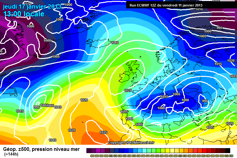
http://www.meteociel...M1-144.GIF?11-0
2 runs the ECM has done that- lets hope the UKMo way of thinking is correct...
S
Looks ok to me. Very cold but mostly dry. Heights rising a bit to our north.
-
Just viewed a GFS run that is full of snow potential with central and eastern areas being absolutely buried yet all I see on here is negative comments.
UKMO also looks ok to me.
-
Hi All. I have created my own weather page on facebook and would be grateful if you would have a look :-)


Winter Model Discussion - 12/01/13 06z Onwards
in Spring Weather Discussion
Posted
That's from the 6z (bottom right hand corner).