
- Popular Post


WhiteFox
-
Posts
1,181 -
Joined
-
Last visited
Content Type
Forums
Blogs
Gallery
Events
Learn About Weather and Meteorology
Community guides
Posts posted by WhiteFox
-
-
17 minutes ago, bluearmy said:
Good analysis @IDO -
i think the Canadian stays just strong enough to keep the euro trough fed out to the end of eeek 2 and the developing scandi ridging should mean the uk is in the battle ground area - by that time the wild card of downwelling is thrown into the mix
Yes. Need to watch developments for early next week as it looks like being a bit of a forecaster's nightmare by Monday. Still a lot of detail to resolve. Excellent analysis as always Knocker.
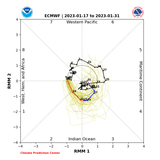
MJO continues to show a push through phase 6 and trying to get into phase 7. At the very least you would be hopeful that the signals are not counteracting each other as they have been recently. If we can get to day 4 as modelled then perhaps with a little help from tropical forcing we make see the Canadian PV lobe start to relax its grip on our winter and enable pressure to build to NE?
Downwelling of SSW has to happen sometime (it can't just disappear into the ether), so as Catacol said yesterday, maybe we do just need a bit of luck!

-
 2
2
-
-
7 minutes ago, sorepaw1 said:
Tonight's 18z for this Sunday night
I'm surprised no one is talking about it .
It could be potentially quite disruptive
For northern areas eastern area's and the south east.
One to keep an eye on. Gale Force winds and frequent rapid shower activity.
Below freezing at night in a bitterly cold wind.
Drifting snow even to lower levels is possible no guarantee but possible
Locally disruptive to hills and steep slopes .
Unable to sleep? Looking at a weather model will help. So my insomnia led me to the t+120 fax. It's a lovely chart for those who like it cold. An occluded front pushing in to cold air with sub 528 air thickness.
So, hopefully some wintry PPN blown in on gale force WNW winds, certainly snow on the hills from that. For the second course, a secondary low moving SE from Iceland....
Sometimes we worry too much about things way in the future. The end of this weekend has more than a little interest and in winters past we'd have taken it as a stunning chart (if you are that way inclined of course)!
-
6
-
-
3 minutes ago, snowbob said:
Is that a predicted 7
sorry if wrong
only just learning mjo this week
It looks increasingly probable that it will make it into phase 7 at a reasonable amplitude. Positive for blocking in better positions for us ..
-
2
-
 2
2
-
-
3 minutes ago, kold weather said:
Also, the Arctic forecast has gone right down the pan as well recently, the upper high not making any near as much inroads.
Yes, that really stands out. The models keep showing a negative AO on the cards, yet it keeps failing. All lessons for future events I guess!
-
2
-
-
1 hour ago, IDO said:
A lot of the experts viz background signals are suggesting from late Jan the MJO will help with a Pacific wave. The mean above is, in fact, contrary, with a Pacific Trough. The GEFS have been picking this up for a day or so and bringing it forward and more defined. We wait to see if other models change their MJO signal.
It's all a bit muddy right?
The trade winds burst has eased through and it looks like forecasts for MJO progress further through phase 6 and on towards phase 7 than was the case a few days ago. Possibly leading to more of an EN rather than LN imprint over the Pacific and PNA?
Increase in Frictional and Mountain Torque also may help to shift pattern somewhat. Been trying to get to grips with this with Tamara's assistance, so hopefully starting to get a bit more idea on what on earth it all means!
In which case, suggestive of blocking possible to NE at some stage, especially if MJO can continue at a decent amplitude to phase 7. Of course, a lot depends on how the PV lobe over Canada behaves and further impacts of SSW...
A waiting game, but hopefully it won't take until the tail end of February!
-
5
-
-
4 minutes ago, Johnp said:
I think people have gone a little stir crazy due to this poxy winter so far.
I'm still trying to get my head around how certain people think this is a poor chart
I remember in the past, the above chart would have sent weather forums into meltdown!
Back in 2003 we'd have banked that chart in a heartbeat! I guess last year has raised expectations!
-
2
-
-
21 minutes ago, Severe Siberian icy blast said:
What a silly post, 5c and cold rain on low ground doesn't quite spell a cold spell in January does it?
Oh I have 0.3cm on the floor that's melting before sun rise. Great cold spell
Looks like a wintry scene to me, and it's better than we get here most winters these days!
We are in a cold spell at the moment that is supportive of snow. Countrywide snow events are a rarity in this country, and it is what everybody's searching for on here, but I think it's a little inaccurate to say we are not in a cold spell!
-
3
-
-
1 hour ago, chris55 said:
This could be an omen.....when the recent easterly suddenly disappeared it was the lesser ICON model that first picked it up, around 120 IIRC. Then ECM followed.
Not entirely true. ICON was one of the last to show the easterly, but did show it just before the ECM moved away, and then the ICON flipped back. There was a brief period of a few hours where all the models showed the easterly including the ICON. I don't really buy into this whole ICON being the bee's knees business. The GFS on the other hand was pretty resolute on the easterly for a long time but the parallell was not. I'd probably take the GFSp over the ICON to be honest.
-
1
-
-
Best hit I've seen from a NW flow here in a long time! Air temp still 0.7, dp 0.
-
2
-
-
Heavy PPN doing its job and freezing the surface... Temp 0.8 dp 0.
-
3
-
-
Temp 0.9 dp 0, but no PPN... Hoping brighter echo to west makes it across.
-
Light to moderate snow. Temp 2.2 dp 1.
-
Sleet now. Temp and dewpoint falling...
-
1 minute ago, jtay said:
The word from the office in Stokenchurch is that it's snowing heavily there and settling.
The radar suggests that it should be rain/sleet up there.
It also suggests that conditions should support snow here. Not happening, I'm afraid.
Doesn't surprise me. It's my go-to place in the area if it's marginal and I need a snow fix! Always drive up towards Christmas Common.
-
17 minutes ago, Ben Sainsbury said:
Now just starting snowing in Reading with big flakes!
Hmm. Must be PPN intensity lowering the freezing level. Just south of Reading here and missing out on heavier PPN bursts. Drizzly with temp of 3.4 and dewpoint of 2.
-
45 minutes ago, kold weather said:
Got to say the GFS is proving utterly useless when it comes to the Arctic at the moment. 4 runs today and 4 wildly different solutions. 00z has an arctic high that links to the Azores high ridge, the 06z attempts a cross polar flow from US+Russia then pumps up a strong high from Russia, the 12z doesn't even bother at all with the first arctic high, then eventually creates one at the death of the run and the 18z develops 2 highs via ridges in the Pacific.
Indeed the GFS has really struggled with the Arctic setup; AO charts have swing about quite a bit and if you look at the latest set showing observed v forecast it actually sits above the spread from previous forecasts.
If we do finally see the SSW moving down then I don't really have a lot of confidence in how it's handled by the GFS going forward.
-
1
-
-
- Popular Post
- Popular Post
1 hour ago, SLEETY said:even in an average winter ,you would expect one decent snowfall.Unless things change fairly quickly this winter is going to end up a complete shambles and hopefully the end of long range seasonal forecasting ,as it proven time and time again ,their are too many variables in the U.K. climate to forecast weeks,months ahead.
When FitzRoy first started providing "forecasts" back in the mid-nineteenth century, there were plenty of detractors who said it was a waste of time: the weather would do whatever it wanted.
FitzRoy, of course, was totally reliant on observations telegraphed to him from a relatively small number of sites around the country and he had to collate it all by hand.
Now we are able to produce reasonable forecasts a few days ahead, of course we are going to try and look further forward. We find ourselves in not too dissimilar a position to FitzRoy: we have some information, but are not yet sure how it all fits together. That will come with applying and testing theories and refining theories when they do not work out as expected.
I suppose part of that involves putting yourself up for criticism when things do not work out as you perhaps would have forecast. But if it wasn't for the pioneers willing to risk their reputation back in the early days of forecasting (or indeed in any science), then we would not be so advanced as we are.
It is easy to sit back and criticise others when things don't go as forecast, but you just have to accept that a lot of this theory is still fairly young. Those who find it an interesting line of inquiry will continue to pursue it despite the detractors. If you choose to ignore forecasts in the future then so be it; just don't whine about it!
-
13
-
3
-
44 minutes ago, bluearmy said:
Eps extended are less flatter jet again to our west with more of a mean ridge again .... nothing spectacular..... need the clusters to show how the probabilities sit
just a wonder that now the downwelling wave is approaching the trop, is the modelling going to be prone to even less reliability ?. Not that it’s been great for the past week or so but at least we know what went wrong with the east American low not behaving .....
It's a fair question and will all add to our knowledge for future events! I guess it would be too much to ask for three consecutive years with an SSW so we may have to wait a while to put the lessons from this one into practice! Will have to go through some of the older threads and take copies of the various charts from the start to compare for the future.
-
1
-
-
14 minutes ago, Singularity said:
Good to see the enthusiasm
This is a good site for keeping an eye on things. Some educational value too:
Thanks, duly bookmarked! A lot of the US sites Google directs me to are currently unavailable for obvious reasons!
It seems that this year's SSW is almost the opposite from last year in terms of affecting our weather. Should still be a good chance of something exciting cropping up soon!
-
3
-
-
16 minutes ago, Singularity said:
Positive signs today for both trade wind burst ceasing soon and MJO making more progress into P6 before being subdued. Both being intertwined.
The additional delay toward the final days of the month of the stratospheric downwell into the troposphere may actually have helped here; the MJO suppression is largely in response to that taking place.
Interesting! It's new to me, so trying to get my head around it all!
BTW, where did you get the Hovmoller chart?
-
1 hour ago, Singularity said:
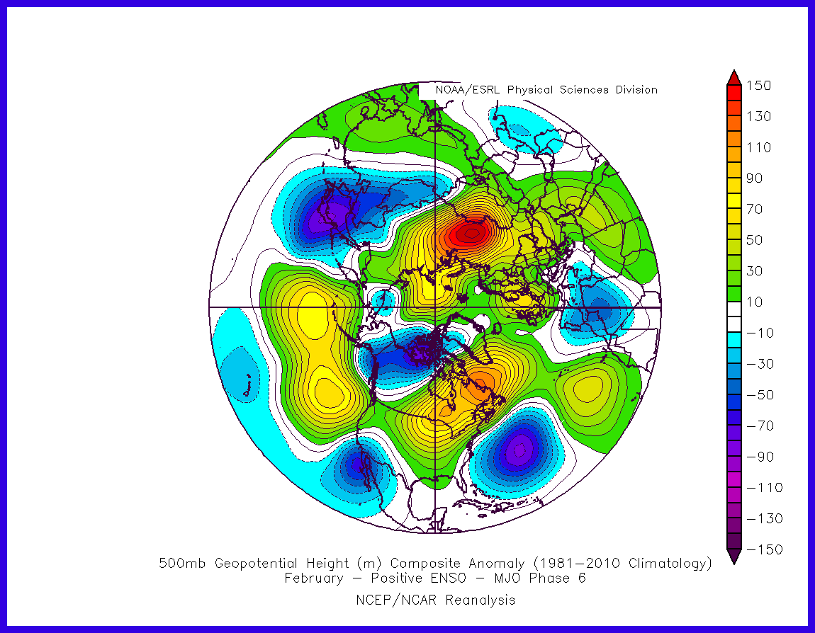
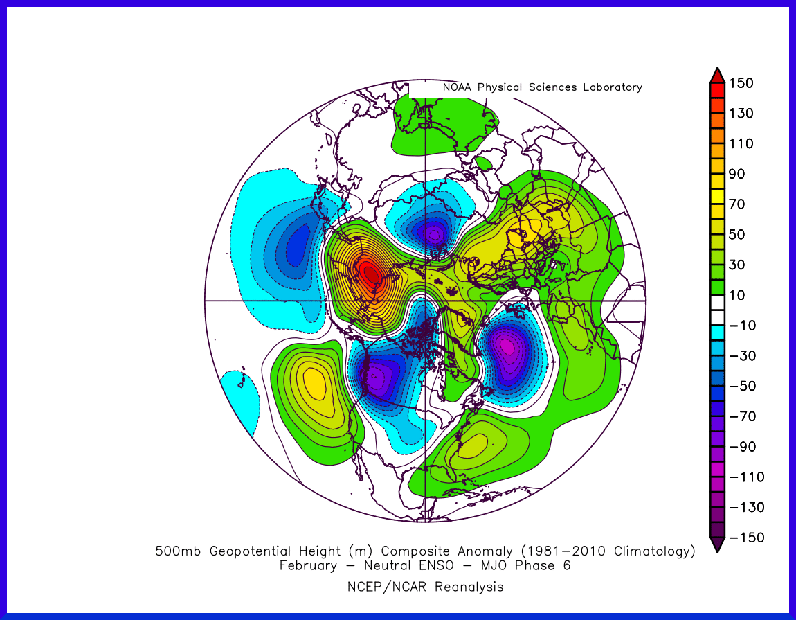
Agreed regarding a Scrussian ridge pattern gaining ground as we see the Azores High increasingly subdued. It may have some relation to the MJO struggling to make it past P6; with a Nino background the composite looks supportive while with a neutral one it also is but without the crucial low heights over Europe for us so let's hope the Nino state puts up enough of a fight;
...not that these are to be taken too directly anyway, but I do think they can be of some use when considering the validity of certain model trends.
If we are to be heading down that route, then reasonable to expect that GFS will lag UKMO and ECM as it's always had trouble with splitting the jet around such features. GEM tends to be on-and-off but when 'on' it tends to outperform GFS quite a bit - which makes the D5+ progression of the 12z of great interest, albeit after allowing for the overcooked N. Atlantic troughs when it comes to D7+.
Interesting that the P6 ENSO+ MJO composite is friendly to mid-Atlantic ridges making it a good way north - it suggests that GFS' repeated attempts of late may in fact represent the model seeing the Atlantic part of a combined route forward that sees troughs becoming temporarily 'enclosed' across mainland Europe by ridges on both sides and to some extent to the north, with the transfers from the Canadian vortex separated by longer pauses during which more of a cold continental feed can feature for the UK.
Doesn't this appear to be part of the problem though? The Pacific pattern seems to have been stuck in more of a LN rather than EN state with a PNA only oscillating between slightly positive and slightly neutral.
Also, the trade wind burst over the IDL leading to the MJO becoming subdued in phase 6 may impede blocking progress upstream.
Have to wait for the trade winds burst to work through before seeing a more favourable upstream pattern perhaps. Just musing....
-
Here is the GEFS MJO plot for balance. Barely gets into phase 6 before falling back. Of course, it is only the GEFS extended range, so nothing set in stone there, and a weakening phase 6 is far better than a strengthening phase 4 that we are currently seeing!
-
2
-
-
13 minutes ago, Penicuikblizzard said:
this has been a very typical 1990s winter with the uk high pressure dominated and mild
I keep seeing this, but my recollection is that the 2000s were worse than the 1990s, until we reached the end of the 2000s at least.
Down south the 1990s were far better for cold and snow: Feb 1991, 1994, Jan/Feb 1996 immediately spring to mind and in Nottingham Dec 1996 and Dec 1997 brought some good falls of snow.
The period from Jan 2001 to Dec 2009 brought nothing but very transient falls for the south. That was when the term "large teapot" came to the fore!
-
2
-
-
31 minutes ago, northwestsnow said:
I'm pondering about the MJO at the moment-
Does anyone have the latest plots? Suspect we might be getting a bit of assistance looking at the 00z runs broadly..
ECM forecast to move into phase 6 around the 23rd. Think part of the reason we saw the easterly blow up is that it was forecast to edge into late phase 4 and then cycle fairly quickly through to 6, but last few days have seen a trend towards earlier in phase 4.
Not sure it's worth posting in here anyway as it just gets lost amongst the other noise!
Also, maybe worth noting that GEFS loses the phase 6 signal fairly quickly and it descends back into the COD. Worth keeping an eye on...
-
1
-
2
-


Focussed Model Discussion
in Spring Weather Discussion
Posted · Edited by WhiteFox
typo
I know what you mean KW, and as has been amply proved this winter, each SSW is different. I think the most we can say for now is that the NWP models struggle hugely with the dynamics at play. Looking back through some of my archive charts of zonal wind means, we have seen many forecasts show that the reversals are set to propagate down to the troposphere, only to see them back off as we get closer to the time. This would seem to back up evidence that suggests that an SSW does not always impact the NAM in a way that drives cold air to our latititude (and longitude!).
Is this bcause of the particular setup of the QBO at the current time?
As we know, we are in a period where the QBO is descending Westerly, so is this causing the painfully slow downwelling of the SSW? Last winter we had a descending Easterly, so it could be that for future SSW events we look for a combination of descending Easterly QBO + Warming to bring a faster response to the Troposphere. If we do not see much of a reaction, then perhaps this year can be added to the evidence pile for future reference.
On the other hand, as Singularity has noted, the Pacific has also been behaving a little unexpectedly. As we move towards an EN event we should be starting to see this reflected with more of an EN imprint on the PNA which, suggests a stronger Azores High and troughing to the East (taken directly from https://climate.ncsu.edu/climate/patterns/pna as I'm away from my desktop and don't have access to my usual archives!) :
But, according to the CPC, "ENSO - neutral conditions are present.*", although the forecast remains for EN to develop and SSTs are anomalously high. Having said that, the 14th January update states that SSTs have actually slightly cooled. So we seem to be in a neutral ENSO, although still forecast to push towards EN+. Unfortunately, I cannot access the site to produce the anomaly charts for such a setup due to the US shutdown, so I am left with pondering (unless someone has some other links for such plots?).
But, what is the PNA actually showing?
For much of winter it has been slightly positive to neutral, but is forecast to trend negative. It would appear that perhaps the move towards EN+ has not had a great impact on the PNA as yet, but we are seeing some effects on our side WRT an anomalously strong PV over central N Canada and an anomalously strong Azores High? GFS NH500 chart:
Further to that, we do see heights building in the Arctic (segueing neatly back to the SSW impact), but again in the 6z GFS run and in the 0z ECM, we see the strongly negative AO signal disappear in the middle of the run only to reappear later on - jam tomorrow as the cliche goes on this forum.
Amidst all this, perhaps Catacol is correct: we just need a bit of luck to get some deep cold to come our way. Meteorology is a science, but I'm sure everyone finds themselves looking at a chart sometimes and thinking, "If only.."
Apologies if this is a load of garbage; as I've previously said, I've been studying this a lot recently and thanks to Tamara and Singularity for pointing me to lots of charts which have probably sent my head into a spin. But, if nothing else, there are plenty of topics for debate right?