


Smiler1709
-
Posts
295 -
Joined
-
Last visited
Content Type
Forums
Blogs
Gallery
Events
Learn About Weather and Meteorology
Community guides
Posts posted by Smiler1709
-
-
Afternoon folks
looking forward to cold week ahead and hopefully some snow. After looking at the latest GFS I think we can expect which path the low will take. Was hoping it would take a more northern France path but the models seemed to all be singing off the same hymn sheet.
With low heights in the med I couldn't work out why the low was heading straight for Blighty. Checking then jet profile I found the answer. Still going to be cold for most but snow will be restricted to northern areas. Still time to change fingers crossed. Hope everyone is well

-
 2
2
-
-
do a beast from the east followed by the wimp from the west ?
-
Im on the fence here tbh, going to enjoy the next few days with my little one and hopefully she gets some snow. I hope the models correct themselves by tomorrow's runs otherwise it could be the new trend. Have a nice evening folks
-
Anyone living below the dreaded m4 line would ideally like GEFS perb 20 as a example, low pressure running up France dragging the cold uppers over the uk keeping any precipitation as snow and lots of it to.
-
5
-
-
Most of the other models disagree with what the GFS is doing with the low system, apart from the UKMO to some degree, from past experience I'd say the GFS is wrong and will correct the low running through France. Seems to always be the model which is a massive Atlantic fan and loves to bring it back in early only for it to then push it back day by day by day.
-
3
-
-
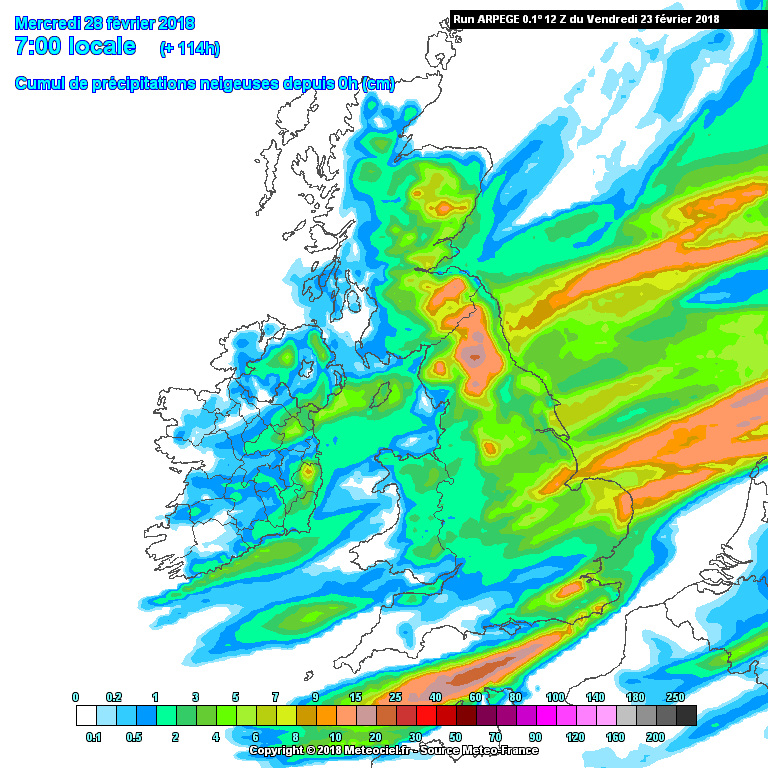
2 minutes ago, Man With Beard said:
I don't know if perhaps this kind of micro-analysis of the snow potential needs moving into the dedicated cold spell thread ... but just thought I'd post the latest ARGEPE snow chart as to me it seems a reasonable idea of what to expect on the ground by Wednesday morning:
Seems very plausible, I think depths will be deeper but those areas do seem the most likely places. Shower bands will track from NE to SW across the country, some will strike gold and others will be left dry but really cold. I reckon a few unexpected troughs will form at short notice and bury some places that are expecting little.
if I was a betting man I'd say a band through the Thames running SW over the South Downs and exiting between Portsmouth and Southampton ?❄️
-
1
-
-
5 minutes ago, offerman said:
Just looked at GFS charts, what a let down for Thursday. Mild incoming and moment north of it with cold ( no where near as cold) elements moving around it.
Bit of a let-down much shortened cold spell regarding GFS hope it reverts back to lengthening it on the next run though.
Gfs will correct itself, it loves to introduce mild weather. I think in the next 24-48 hours it will correct that low pressure south.
-
2
-
-
4 minutes ago, Nick L said:
What in god's name is the GFS doing in FI?
Losing the plot? ?
-
1
-
-
22 minutes ago, snowray said:
Yes I make you right there, tomorrows runs will make everything a lot clearer I'd say.....
Well maybe?
Hope so, ideally I'd like the high pressure over Scandinavia so we can squeeze that easterly for longer ?
-
 1
1
-
-
3 minutes ago, weirpig said:
Short ensembles. A couple of mild outliers that are distorting the mean. Some very cold runs in there
I'd say those milder runs are the ones where the high pressure is to close to the uk and therefore the coldest air is dragged into mainland Europe.
-
Noticed that a few GEFS members have the high set up over Scandinavia which in the long run if we want a more sustained easterly that's the path we need. I'm not taking anything after 144 hrs on the GFS ATM. It's throw out different solutions every run. Looking forward to some biting cold days ahead ?
-
1 minute ago, Summer Sun said:
UKMO 12z has the -12 line in the SE corner at t144 with the -8 line around the Scottish borders
00z had the entire country under the -8's with Lincolnshire south under -12's?
Obviously, the time frame is different but that is definitely a shift south for the coldest air - not that the UK would be all that warm anyway
Shifting south seems to be the trend, I've noticed the last few days that the ARPEGE has modelled the high to sit off the north west coast of Ireland. Giving us more of a dry cold rather than very cold maybe snow. Hopefully ECM keeps the high further north over Iceland/Greenland. How do you reckon this spell is going to unfold?
-
Been abit worried that the models seem to be pushing the real cold back by a day, seems like it's arriving on Monday now. From this mornings runs that seems to be the favoured day compared to recently when Saturday night/Sunday was forecasted. Is this something to worry about or is this the models just getting to grips with exactly where the high pressure will set up?
-
I just knew the downgrades were coming ?
-
just spoke to my mate from council and blew every chance of this cold coming when I said it's going to get cold. what he told me next has sort of put my mind at rest considering if we are going to have this cold spell. All he said was the high ways lads (gritters) are on double shifts from Saturday. i think this is actually going to happen. he didn't tell me any more because I interrupted his football ?
Cant believe what the GFS 18z has shown it looks great for all of us. ?
-
1
-
-
Question for the pros.
say if the current GFS and ECM are on the money, will snow events come up in short notice? I remember in 2010 when we had 20cms down here on the south coast and the forecasters only really knew about it at short notice.
can you see these type of scenario's happening with a set up like this? Sorry for lack of knowledge.
-
3
-
1
-
-
1 minute ago, bradythemole said:
GFS going for massive blizzard for the south at Day 9-10
Turning to rain though as it pushes milder air back in. All FI though so will definitely change. Looking great for some proper cold though
-
1 minute ago, Ice Man 85 said:
doesn't have as much support as the OP does though which is a shame. Not really a fan of "short and sweet".
Mate go to bed, this could be the most severe cold weather the uk has experienced for years, once the cold is in I will bet that the mild gets pushed back with each run. With snow cover and a extensive cold pool it really will take a lot to budge. That's if the mild even gets in. It's one run and is going against the trend even if it is FI.
-
4
-
1
-
-
Much better from GFS 6z, much better position for the high pressure ?❄️
-
2 minutes ago, LRD said:
I'm confident because what we know about the background drivers and the long wave pattern makes the output feel 'right'. Ordinarily, I'd be negative but not this time
Hopefully mate, very limited knowledge in weather so purely commenting on what I see in the models this morning.
-
2
-
-
4 minutes ago, Weathizard said:
Not great ensembles?
Yea certainly has put me back my feet this morning, hard not to be abit negative when there are many different solutions. I got a feeling this is going to be a lottery with the weather gods. GFS will hopefully correct itself on the 6z.
-
GEFS are not great this morning for deap cold, some struggle to bring in the easterly at all, others place the high latitude blocking to high and we're left with just a chilly SE breeze. I really want the ECM to be right and I know there are many more runs needed. Sitting on the fence here because it's been a shocking winter down here on the south coast and we really need the omega of runs to get us snow to finish winter. Looking forward to a day of ups and downs in the model thread.
-
Heavy snow here at box hill Surrey, about 2cms in ground
-
GFS 18z havin none of a Scandi high in the latter stages. Hopefully it sorts itself it tomorrow otherwise are be having a right old word with it.
-
1
-


South West and Central Southern England Regional Weather Discussion 22/02/2018 Onwards
in Regional
Posted
Really coming down hard here at the moment. ?