


ALL ABOARD
-
Posts
537 -
Joined
-
Last visited
Content Type
Forums
Blogs
Gallery
Events
Learn About Weather and Meteorology
Community guides
Posts posted by ALL ABOARD
-
-
12z has Atlantic mobility returned by just 84 hours?

Either its so far in over its head its unbelievable or the met are wrong??
-
3 minutes ago, lambgregg1977 said:
Why the charts are showing us these tease frames is annoying. The trend is already set to become less cold next week.
I dont know what your basing this on? If its the met outlook then just remember this 'cold spell' was only supposed to last two days
They have to be careful what they write but as fergie's comments earlier have shown they aren't sure 'when' or even 'if' this break down will happen.
-
 3
3
-
-
If someone said to me high pressure frosts and very cold nights with a long way back to anything remotely warm i'd have taken it!!!
6hrs difference!!
-
2
-
-
- Popular Post
- Popular Post
Atlantic pushing through early next week?
What Atlantic??????? GFS then sets us up with bitterly cold air coming from the continent?
-
12
-
You can clearly see how it is prolonging the cold day by day.
-
4
-
-
14 minutes ago, bluearmy said:
ALL ABROAD, the tweet says that 40% of the eps 'maintain or even retrogress cold block'. not quite the same as your post.
Sorry yes I stand corrected !
-
12 minutes ago, fergieweather said:
It's broad-brush catering for wet snow Thurs daytime in parts of south as any heavier pulses of ppn backwash runs S associated with WBFL dropping down steadily <400m. Areal probability of snow actually settling to meaningful amounts in SE third of UK currently rated about 20%, however. Modified E4 with WBFL here to illustrate progression:
So nice to see you back
I can stop using my girlfriends twitter now to keep up to date with all your tweets haha. Just reading your latest one that 40% of EC-ENS,retrogress the block? Would it be fair to say over the past few days this has steadily gone up?
As for the GFS it's seems its up to its old tricks again, the variance in theme in a six hour gap is well 'confusing' and is slowly going to lead me into an early grave.
For me it goes wrong or right given your take on things as early as just t78 as the low pressure stops and thinks I'll head north east instead.
-
1
-
-
2 minutes ago, Timmytour said:
Would I be wrong in thinking that about the same time last year we had the same thing? And, in line with what the Met said at the time, rather than what we all hoped, all we got out of it was a 7 day cold spell at the beginning of Feb in an otherwise write-off winter for those of us coldlovers down south?
I'm no expert and I've only just started learning about the strat and what implications a SSW has on us. A SSW doesn't necessarily mean freezing cold and snowy for us, although it does increase our chances. Its interesting at the moment to watch the gfs bring the temperature increase forward by 6hrs over the past few runs. Im sure the more knowledgeable posters in here can answer any further questions for you
-
Its getting quite toasty up there !!!!
-
1 hour ago, CreweCold said:
Oh my UKMO why do you keep doing this to us?! Best day 6 chart for a couple of days
Gem isnt far behind at 144 !
-
1
-
-
Gem and ukmo both rebuild the greenland heights!!!! Gfs has a go but does not quite get there. Interesting ecm coming up!
That should read links the greenland heights with atlantic heights.
-
1 hour ago, feb1991blizzard said:
Something interesting is going to happen on the last few frames of GFS 18z, anyone guess? I will reveal all in a few minutes.
Strat warming up? In all seriousness 18z is a much better run. Keep an eye on the strat temps over the next couple of days apparently its supposed to get quite toasty.
-
1
-
-
9 minutes ago, winterof79 said:
I have splinters in my fingers.The UKMO chart has more of a pronounced greenland ridge on its eastern flank looking at that.The s/e extent of the low toward s/w Greenland looks very similar on both
I agree that there is more of a pronounced ridge but IMO the ridge is better because the low heads n/e allowing a better ridge to form, I may be incorrect but that's my take on it.
If you fast forward to 144 on both you can see how the UKMO ridge is far better as the main energy has headed north east?
-
- Popular Post
Here's a little sketch to explain in simpler terms about what Steve is speaking about
This is the ECMWF for 96 hours and 120 hours!
We can see that the energy heads south east and its game over from there in terms of long term potential.
Now here's the UKMO for 96hours and 120 hours!
The energy heads north east and allows a more favorable setup to emerge.
p.s ignore the overlay on the ukmo 120 hour chart forgot to delete the previous one.
-
15
-
8 minutes ago, Timmytour said:
The most frustrating thing with the models at the moment is trying to remove a quote that you intended to replying to the night before but changed your mind, from a post you want to make now!!!!!
Worth remembering for anyone worrying when they read someone say that the models are bringing in an end to a cold spell in eight days time that eight days ago they weren't showing us a cold snap!Hello, If you hold 'CTRL' and right click on the quote it gives you the option to remove it
hope this helps!
-
3
-
-
6 minutes ago, winterof79 said:
I do not see 8 westerly based scenarios there and they are cold
http://www.meteociel.fr/cartes_obs/gens_panel.php?modele=0&mode=0&ech=204
I agree I was talking in reference to the pattern that would evolve from these. Still all to play for but maybe thats why the met are holding off on a long spell as apparently around 20% of ec ens agreed.
If you skip through to 228 you'll see what im talking about
-
6 members of the gfs ensembles have that low affecting our weather by 204 and bringing in mild dross again! and after Fergies tweet this must be where they are struggling with the longevity of the cold.
-
Not as quick at getting the cold in but surely people must be happy with this chart i.e long term for cold. The heights across Greenland just build and build!! No easy way back to warm from there imo!!
-
4
-
-
As i have mentioned previously the arctic high is once again more robust !! slight upgrade so far for me
Comparison for the same time! almost 10mb in difference
-
1
-
-
@paul78310011 ...but my hunch is it probably returns mobility too easily. Often an issue in these situations. But hey-ho, time will tell!Regarding the 18z...Is there a sneaky hint in there?Dissapointing 18z ensembles btw. I dont know wether to laugh or cry! Not as prounouced as the 12z and after the ecm I was expecting to see some follow this pattern. Im going to be diagnosed with vertigo soon with all these ups and downs!
-
I give you perturbation 7!!!!
anyone want to raise me? in all fairness though scrolling through the ensembles and there are a wide variety of options. Most of them takes us into the freezer though and keeps us there!!!!
-
8
-
-
- Popular Post
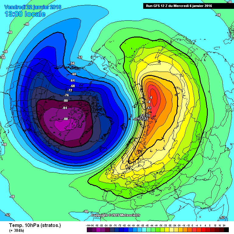
GFS also gives us this towards the end of the run?
Major strat warming there!!!!!!
This is for around the 22nd of January.. cards are starting to fall into the 'cold' category.
-
11
-
Nice to see the pressure rising over Greenland already by 24 hours on 12z its already up to 1040 mb
on the 6z it takes 120 hours to achieve this..
small upgrades?
-
1
-
-
32 minutes ago, joggs said:
Maybe I fergieweather could she's some light on tge glosea))))
Unfortunetly to my understanding Fergie weather will not be posting on here anymore due to reasons of ummm well....
Back to the charts and I said when I was watching the 00zs gfs come out, the gfs is pushing more and more heights not only into Greenland but it is building them more into the arctic. This allows the heights to link better with the Greenland heights. This is something i'll be looking for when the 12z starts rolling out.
-
2
-


Model output discussion pm 13/01/2016
in Forecast Model Discussion
Posted
I can never in all my time ever remember difference like this at T96! INCREDIBLEEEEEEEEE!!!!!!!!