


vladthemert
-
Posts
572 -
Joined
-
Last visited
Content Type
Forums
Blogs
Gallery
Events
Learn About Weather and Meteorology
Community guides
Posts posted by vladthemert
-
-
seems it has developed here. Reports of tornado in Cleethorpes this morning.
Also reports tornado in east riding near hull done damage.
 Live updates as 'tornado' hits Humberston damaging homes and vehicles - Grimsby Live
WWW.GRIMSBYTELEGRAPH.CO.UKVehicles have been flipped onto their sides and many homes damaged following what is understood to be a 'tornado'
Live updates as 'tornado' hits Humberston damaging homes and vehicles - Grimsby Live
WWW.GRIMSBYTELEGRAPH.CO.UKVehicles have been flipped onto their sides and many homes damaged following what is understood to be a 'tornado'-
 2
2
-
-
Don't think been complete bust Mapantz here we did get hail storm last Tuesday I think it was I read also hit Sheffield also got it. I don't know if Lincolnshire still got chance of early morning activity from Netherlands, Belgium storms drifting in still.
-
20 minutes ago, Winter Cold said:
Yes hail showers in Sheffield today, can see the hail coming out of this one that I caught while at work this afternoon

That might been same one hit us around 4 pm one cloud looked to have rotation as it had turned on itself it was windy as it passed
-
1
-
-
Had hailstorm here not too large in diameter 3 to 4 mm sized hail. Saw a beautiful cloud looked to have frontage rotation as it was turned inside itself was windy as it passed. I would assume updraft. Roughly about 4 pm although don't exact time must been good to see on radar.
-
1
-
-
21 minutes ago, Summer Sun said:
Euro 4 for Tuesday strangely has some rain in places
Around the Hull area could be in the sweet spot on Tuesday morning
6am Noon
That's looking nasty for my location I may need to send out
. can I ask if this came off below could this be very bad for my location would the line just keep feeding and stall.
-
Posted on Lincolnshire thread in regional strange day warm then short Hailstorm with followed short burst heavy rainfall then as quick started back to warm.
-
Not sure what happened yesterday at my location it was warm yet suddenly severe hailstorm hit around 3 mill in diameter. Noticed on radar looked like a small squall line from Goole to just off the coast into north sea. Then suddenly really heavy outburst of rain only lasted few minutes but strange convection. Noticed nobody else reporting this so very localized. Did anybody else get this yesterday think it was just gone 1pm.
-
wow lightening sounds ominous. Lets hope everyone stays safe. I did not know the storm the little bins are out.
-
Cant wait I want to stay up but doubt I can as not due here till early hours.
-
Thats typical of gutter rags though
-
3
-
-
Thanks Hurricane Andrew One thing here, don't take a lot for trees to go down they just not used to big winds. My app says 44 mph Gusts for my location but don't know if it updated to latest models. Never had Police warning don't drive with previous storms, which makes you worry and sit up. Saying that at least we not over the pond with the situation their facing.
-
Sounds fun for the region. Our paper police warning people not to drive around 2am to 4am. Big tree in the back hope it stays up.
-
1
-
-
Seems met no confidence today but have put weather warning Norfolk, Suffolk, Essex and Kent for monday
-
some beautiful plumes here. This slight warning was justified. This been quite year so far, Northern half of Lincolnshire tends to just miss out but not this year I think we been in the action just much as the south of the county.
-
cant be greedy second storm this year so far. there tomorrow looking promising. see you all tomorrow.
-
yes GlennP2 first hammering just hit my location as you speak. they just been north slightly Immingham Grimsby
-
been one or two flashes here
-
1
-
-
Summer Sun nice summery. Got ask is there hint of the middle finger to Lincolnshire.
-
just looking at the rain radar. Has this front stalled over the east coast Lincolnshire. My location has had quite a bit rainfall all day.
-
Grimsby had short heavy burst today with Hail, would say couple mm in diameter. Was not aware any convection today happened roughly 1 pm.
-
They always say swings and round-abouts
. Then again you might be on a roll. .
I dont know why it was bad seem according to ease we was going to miss it but seem to concentrate in our area.
-
1
-
-
On 6/28/2016 at 12:05, Azazel said:
complex set-up today, so my map looks like a picasso painting but these are the areas I would go for.
Hats of for getting our region red square right on the east coast
-
3
-
-
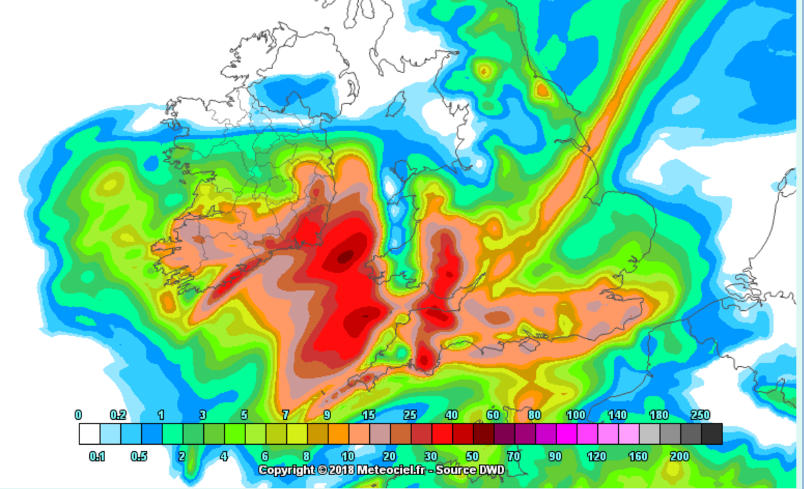
crazy rainfalls in last 20 mins here in the area rain today. Looking like 70 mm registered on the live radar I thought my weather station was playing up the road was like a river for short spell as trundled down the hill. amazing only time saw that was few years back when it rained for more spell closed roads of in all over Grimsby.
-
looks like squall line from sheffield to boston developing


 . can I ask if this came off below could this be very bad for my location would the line just keep feeding and stall.

 .
.

Storms and Convective discussion - 25th July 2021 onwards
in Storms & Severe Weather
Posted
wow just read Nick F warning for next 24 hrs going be worry if that severe warning comes off.