


mhielte
-
Posts
216 -
Joined
-
Last visited
Content Type
Forums
Blogs
Gallery
Events
Learn About Weather and Meteorology
Community guides
Posts posted by mhielte
-
-
1 minute ago, Summer Sun said:
Op and mean both go on the warm side of the mean (black and blue lines)

Huge scatter after the 7th though. Really anything could happen! Exciting but nerve-wracking all the same.
-
 2
2
-
-
7 minutes ago, Singularity said:
When it comes down to it, the upstream amplification is what really counts for the longer-term, and it will take a further substantial shift for the Azores low to cause enough trouble to prevent that from doing the job. UKMO might well be at that point which is alarming, though as implied earlier it has enough of a hang-down of lower heights to place an undercut of the high at just +168 hours on the table. Not something I'd bet on, but you never know - we should see what the run gets up to later this evening via that alternative view people have started making use of.
Regarding the Azores low strength in the mid-range, something I noticed with the 12z GFS was that there was much more wave development along the frontal boundary moving south 1st-2nd Jan. This tricky feature could be important for determining how much development potential then exists for the Azores low to work with. Further swings may be possible in the 24-72 hour range, which is unusually close in time,
Really value analysis like this. Great post
That said maybe we know too much sometimes. I'm sure I was far less stressed than this viewing the 5-day forecast on Ceefax back in the day. Page 406 I think it was
-
5
-
-
5 minutes ago, Banbury said:
How can Matt say on the one hand GFS 12z wont be any good for coldies out there and then say wait for full data set before drawing a conclusion ????
Well he can, and he did. However the GFS op is way out on its own after the 6th. Matt is a knowledgeable chap but he jumped the gun a little on this one!
-
2
-
-
2 minutes ago, Mucka said:
A slack continental flow with ice days and UK the battleground between Atlantic and Euro cold - I'd bank it in a heartbeat Crew.
Yep temps below freezing for inland areas at 12pm.
-
2
-
-
6 minutes ago, mountain shadow said:
No, because the ECM is not consistently garbage.
Neither is the GFS. You forget that when the ECM ballsed up the Dec 2012 easterly, the GFS correctly predicted the Atlantic making inroads. We can rank and slate the models all we like, but ignore any output at your peril.
-
5
-
-
17 minutes ago, Paul said:
The GFS has often had a thing about overdoing cold temps over snow, I suspect that chart is a good example of it!
Two 6z runs in a row! Tells you it's not wise to drink early
#newpubrun
-
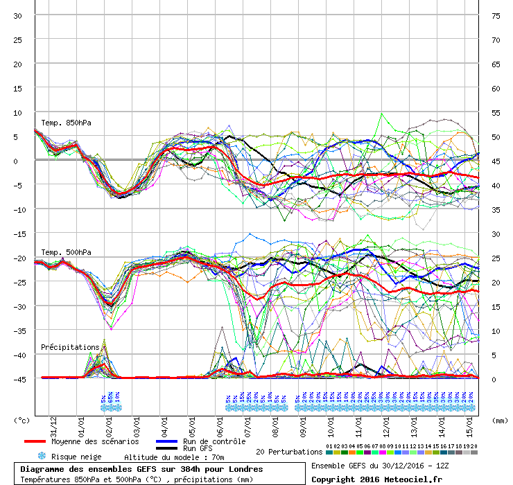
With the inevitable downgrade coming on the 12z (just how much?) I thought one of these might help this afternoon
I'll be happy as Larry if the downward trend in 850s remains from the 7th onwards. Doesn't matter too much if the next op is on the milder side as long as we have the same (or more) clusters supporting a cold and snowy evolution in the 12z ens
-
1
-
-
1 minute ago, pip22 said:
New thread anyone?
New pants more like
Next we'll see just how much of an outlier this epic run is
Good to see the GFS maintain rather than sink the Atlantic ridging closer to the reliable timeframe. That straight tongue of WAA to Greenland is what we need going forward.
-
3
-
-
Just now, abbie123 said:
Hi could this chart bring snow down to the south east England in this setup thanks.
Absolutely, as could the rest of the run thereafter!
-
1
-
-
- Popular Post
- Popular Post
Whatever happens let us enjoy this run for the spectacle it provides. FI or not these are charts worth archiving!
-
10
-
Just now, Summer Sun said:
A cold start to 2017 then a slight recovery around the 4th to 6th before the 850's fall away again
Good to see the clustering from the 6th-9th Jan of falling 850s indicating another surge of cold from the NW/N
-
37 minutes ago, Ali1977 said:
The ENS do not support the Op and look much better at day 8. No spoiler low
Day 10 and there are some lovely northerners, mean back down do -5c again, not sure why so negative in here.
I can only imagine it is due to repeated failures in the past! We feel less disappointed if we 'expect' the worst to happen
GEFS looks great with the op out on its own. Perhaps it is on to something, perhaps not. Good to see repeated signals for more incursions from the north...again
It'll be very interesting to see where the ECM goes this evening...
-
3 minutes ago, mountain shadow said:
As I mentioned last week, I was fairly certain that the initial Northerly would be a brief affair and that appears will be the case. Will the second shot be anymore likely?
I say no, as the AAM, MJO and PV strength do not support it. I would again therefore caution against believing any model output showing a HLB favourable for snow to our islands.
Interesting guess/prediction. I'll save this for future reference
Good to see the northerly plunge still on for the UK despite you saying otherwise on the 23rd. I'll take my chances and pin my hopes on January being a colder than average month with some snowfall
-
7
-
-
2 hours ago, feb1991blizzard said:
There were lots of GEFS members showing uppers very cold for days a few runs ago, they are fast disappearing and with the Met Office outlook not suggesting much PPN after some very insignificant back edge snow on the weekend, it looks like another garden path job again, mind you the background signals never really suggested HLB in the first place. Well at least we can look forward to some frosty clear days and interesting weather .
zzzzzzzzzzzzzzzzzzzzzzzzzzzzzzzzzzzzzzzzzzzzzzzzzzzzzzzzzzz.
I'm shocked that you can call the future with any confidence given the variance in the model output especially after t120. We have a cold snap to look forward to to begin the new year and after that, who knows? All we can do is comment on the potential, whichever way it may lean.
As it happens, the potential is for the cold to stay for a while longer with the prospect of reloads from the north or even north-east if you believe some models this evening. What isn't wise is to dismiss the prospects entirely based on unreliable long-term forecasts and the odd dodgy run. The GFS 12z ensembles show a noticeable upgrade compared to the 6z. Am I calling a snowy month based on that alone? Of course not!
There are plenty of people who read this thread as an education (myself included) and posts like the one quoted are extremely misleading. Is it that hard to view the models with a modicum of impartiality?
edit: I recognise posts in a similar vein to mine have been removed. I understand and respect if mine goes the same route but I feel it is an important message to get across
-
8
-
-
6 minutes ago, Summer Sun said:
Given the performance of the long range models so far I'm urging caution to believing the background signals!
However I will concede we are far from agreement on January prospects after the initial northerly.
-
1
-
-
1 minute ago, Matthew Wilson said:
Yes where's the ECM wandering towards January
:
Exactly where the MetO wants it to wander to?...
"There is also the potential, although with very little confidence attached to it, that pressure may also build to the west of the UK across the Atlantic, and this would bring a high chance of seeing a colder interlude develop." from their extended outlook
-
6
-
-
16 minutes ago, Frosty. said:
Hmm not what I was hoping for..oh well it is winter after all!
Good job you live in West Yorkshire then! Potential wintry showers depending on your elevation.
-
4
-
-
- Popular Post
- Popular Post
7 minutes ago, offerman said:Charts still showing a mild Christmas on the way :-(
I'd be more concerned if it was Christmas tomorrow.
As it happens, it's two weeks away, so put the kettle on and stop worrying
-
13
-
Just now, Gael_Force said:
I'm not criticising Matt or saying he is looking for snow but a lot of the folk on here are. I personally agree that the likelihood is for repeated ridges through the UK but you need something to close them off or it's mild or the much maligned faux cold.
Yes agreed. FWIW I know you weren't criticising Matt
But worth you pointing out others are looking for snowier signals in the anomalies that aren't present at the moment -
1
-
-
3 minutes ago, Gael_Force said:
You need to be careful with those anomalies; that's not much different to what we have just had with the strongest positive between Scotland and Iceland. It just reflects there is normally a big low there.
If people are looking for a cold snowy easterly there would need to be blues through Iberia: pink just shows it is the usual high pressure down there.
True, but in fairness Matt isn't looking for easterlies, more a discontinuation to the mobile westerly pattern later this month
-
4
-
-
1 minute ago, Ali1977 said:
I think the forum needs some positive news from the EC46 and hopefully a day of better ECM and GFS ENS, lets hope that's the case. Yesterday was pretty depressing reading !! Lets not chase snow in the next 10 days, it's not happening and we are to get slightly milder for now.
The milder spell has been a consistent signal for a while now and reflects the recent MetO further outlooks. I agree with @KTtom that it's what happens after this that will determine how December pans out. There are plenty of reasons to be encouraged though, many of which have already been outlined such as the lack of zonality and a still weak jet. I am happy to put my trust in the longer-term outlooks which broadly suggest a return to a blocked/colder pattern as we head towards mid-December + + +
-
5
-
-
There was me thinking we were in a cool/cold pattern already?
850s 4 or 8c above average won't push the temperatures up much lets be honest (worth mentioning that it'll doubtless evolve differently anyway).
-
3
-
-
32 minutes ago, I remember Atlantic 252 said:
I wouldn't even say GFS holds on to the heat? Tuesday warmest for me 19°, not what I'd call hot
It's worth noting the 00z operational was one of the cooler options for western areas in particular.
-
1
-
-
2 hours ago, ajpoolshark said:
personally, I'll just continue monitoring the model outputs over the next 2-3 days before passing any personal judgement on what may or may not happen next week....To write off weather a week before it's happened is foolhardy IMHO. The model output can and possibly will change between now and then
Absolutely.
I'm surprised at some of the more prolific posters in this thread seemingly living and dying with each run. Look to the ensembles for consistency and agreement, rather than accepting every operational chart as gospel.
-
9
-


 #newpubrun


 zzzzzzzzzzzzzzzzzzzzzzzzzzzzzzzzzzzzzzzzzzzzzzzzzzzzzzzzzzz.


Model Moans, Ramps and Banter
in Forecast Model Discussion
Posted
Credit to you if you can call two weeks ahead so confidently! Sod's law might back you though...