


marksiwnc
-
Posts
219 -
Joined
-
Last visited
Content Type
Forums
Blogs
Gallery
Events
Learn About Weather and Meteorology
Community guides
Posts posted by marksiwnc
-
-
2 minutes ago, Glacier Point said:
Fascinating circumstances and prospects right now.
First week of December coming into view, and, with not all the ducks properly aligned (just yet), we are looking at below average temps for much of UK, more so Scotland.
The convective anomaly centred over the Indian Ocean is showing eastward propagation. Slow, but steady.

As soon as that hits the Maritimes, we should see a more amplified hemispheric pattern develop centred on a poleward displaced North Pacific ridge. We are already beginning to see this in the extended range modelling.
The mid Atlantic ridge also likely to gain traction under this regime.
Angular momentum will also spike once the convective wave pushes into the West Pacific with a +ve mountain torque, with likely hemispheric reinforcement of Rossby Wave pattern.
The stratosphere also holding deep interest. That ridge associated with the initial warming phase is starting to look like it will drift around the Arctic basin, becoming Atlantic based week 2-3. With another warming over Siberia, the Aleutian stratospheric ridge likely to be in play over the top of a tropospheric ridge - could well be a sizeable height anomaly developing in the North Pacific through Alaska during that time. So that means we may well have two ridges peprendicular to the Pole - ripe conditions to support tropospheric cross polar ridges. Keep an eye on the GFS and GEFS as they are just starting to advertise early stages of this.
That sounds a lot more promising. I remember our conversation from last week for the fun and games to start dec10th ish. Looks like your going to be close and with @fergieweather informing us of mid December being on the cold side then hopefully we will see some lovely winter charts with a few snow opportunities (I think more especially coastal areas prone to showers from N/NW/NE.) let's hope so.
-
 3
3
-
-
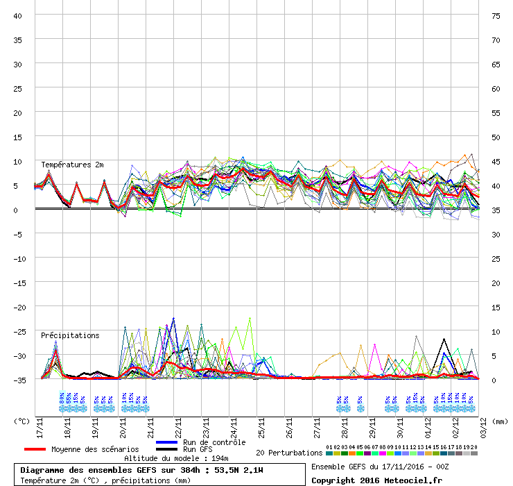
Surely between 140hrs and 240hrs the high pressure would stand up against the low a bit more than shown on the 00z. it seems to shunt it East a bit easy. it moves about 1500 miles in two days lol
-
Heavy rain here all day. flooding an issue along the a55 and heavy snow a problem between Bala and Trawsfynydd
https://mobile.twitter.com/gareth78roberts/status/800799769492942849
-
18 minutes ago, Glacier Point said:
Just outside my 'embargo' period I'm afraid.
Hahahhaha I was expecting that tbh. one things for sure.. weather forecasting will be very hard over the next few weeks or even months with probably a quite rare setup in the northern hemisphere at the moment
-
19 minutes ago, Glacier Point said:
Another run, another ensemble mean suggesting quite an aggressive +ve height anomaly developing over Hudson Bay in the week 2 period with a switch in the flow to the southern arm of the jet over the US. Western Europe left under a weakish upper trough signal (temps marginally below average).
Two things to ponder here.
What's to stop the westward movement of the upper ridge over the Canadian Arctic ? There may be some stratospheric-tropospheric coupling going on, but over time we would normally expect such features to shift their position westwards. That allows for the controlling influence of the Canadian ridge to be negated downstream. With the pattern of tropical convective rainfall beginning to creep back towards the Maritime Continent (non-MJO component), this suggest mid Atlantic / possibly Barents Sea / Scandinavia area modest ridge development. These won't be too obvious on week 2 means or even spreads, but small scale mid to high latitude ridges developing within a flow which is well displaced of its norm would be interesting.
Within this context, stratospheric warming impacts will be around the week 3 / week 4 periods. The tell tale signature for vortex splits is very cold 850 values pouring into NW Russia and Northern Scandinavia. Helsinki, Moscow and Murmansk the locations to keep an eye on for extended range ensembles. Some twitching of ensembles for these locations staring to occur but nothing stark just yet.
Intriguing times.
Gp I know you used to provide an in depth summary of the weather for winter especially. but if you were to place a bet. where would your money be on the likelihood of a very cold snowy outbreak around mid December (or give some kind of percentage wise)
-
2
-
-
29 minutes ago, Man With Beard said:
Still looking at that D10-D15 period ... regardless of uppers, fairly cold at the surface on both ECM (De Bilt) and GEFS (central England) - that ECM control run looks frigid.
Got a gut feeling though that, slightly along the lines of the ECM, we may see another trough slip through the Atlantic block between T192 and T264, and a fresh build of pressure towards Greenland behind? In other words, a repeat of the D1-D5 scenario?
Temps seem to be dropping at the end too which is nice to see. Remember around the 10th Dec is when I expect the fun and games to start
-
3 minutes ago, fergieweather said:
The period by late Nov / early Dec is certainly not without interest, but whether we see technical SSW is another matter. In a way it's by-the-by, because the underpinning signal is conclusively for an exceptionally weakened/disturbed PV into that period and hemispherically, the 300hPa GPH fields really couldn't paint a picture more foretelling of the enhanced blocking potential.
I have a sneaky feeling that Ian has more info that he can't confirm at present but the chances of quite a substantial cold spell happening from 29/30 onwards is quite big. I've said this since end of October.. I think December will get colder through the month but not masses of snow only glancing blows from the Atlantic for south Western areas and Ireland. anyway let's hope
-
3
-
-
Up to 87hrs and there's hardly any change. this is fascinating weather watching. which one is correct. my money is on GFS (again) this has happened over the last few months and I think will happen until the vortex behaves luke it should do. (hopefully not until March
-
1
-
-
1 hour ago, BLAST FROM THE PAST said:
Newcastle at 5/1 is a stormer of a bet. I have £100 on Aberdeen. My LRF later this week will reflect this but Glasgow superb at 7/2!!
BFTP
Never mind that blast what about Leeds 6/1???
-
1 minute ago, Ali1977 said:
Now this is an update - a while away yet but this could be quite some December we have coming if this came to fruition !!
Hahahahha Fergie playing the game surely is a good omen. I think that weather systems pushing up against a strong block over the north of the British Isles would and hopefully will provide some snow at least although hopefully nothing major as I don't know how this country would cope to be honest.
-
3
-
-
2 minutes ago, Froze were the Days said:
hhhmmmm...personally can't see anything in the way of +ve height anomalies to the W/NW as per GloSea/EC of the UK going by the last few op runs from both GFS/ECM heading towards the last 1/3rd of the month, possible blocking to the east yes but unfortunately we could be the 'buffers' for a period and lots of cool wet weather. Nothing too appealing in my eyes.
As Fergie mentioned no Atlantic train as per previous winters just something a bit different with a varying jetstream.
I'm sure the blocking is not until start of December or last few days of November. I might be wrong. interesting model viewing at the moment
-
6
-
-
1 minute ago, Ravelin said:
GFS blowing up one of it's trademark dartboard lows off the tip of Greenland starting at d7. Looks too extreme to be a probable evolution.
Ian f did say that there could be a few windy spells before the transition. this could be what he had in mind maybe??
-
2
-
-
I remember the models were flipping and flopping prior to the major cold in 2010 and to have the met office on board surely is enough confirmation that's it's going to be colder. especially after their outlook update today with the month getting colder and snow to even low levels in the north. I expect the south and especially central parts to be hit by some of the white stuff by the end of this month. time will tell I suppose
-
6
-
-
1 minute ago, fergieweather said:
...albeit equally interesting how we now have an emergent if presently minority cluster (circa 10% in 12z ENS) from the 19th, which - rather than raise heights over Greenland - instead do so markedly above Scandinavia and the White Sea, with a cut-off vortex to our south and a resultant net easterly flow. Varied medium-range shenanigans loom (persist!?), methinks
Hahahahah Ian you know how to wind the coldies up lmao.. I can see December being cold with a wishbone effect on some costs resulting in quite a dumping of snow on exposed coasts. that's my pounds worth. interspersed with drier colder weather in-between. also a few weather systems brushing the south at times. .. see if I'm right come Christmas
1 minute ago, fergieweather said:-
1
-
-
21 minutes ago, vase1234 said:1 hour ago, Glacier Point said:
To be honest gp I am getting lost in translation or I'm failing to understand what consequences this may have. any chance of a round up of what you expect in the next 6 weeks ish??
-
4
-
-
2 hours ago, BLAST FROM THE PAST said:
HP to W and NW. Displaced PV towards Scandinavia at times....Dec. Flow mainly N of West with some potent shots from the north. General early theme. Not a constant freeze out. Early thoughts...
BFTP
Is this your preliminary thought for the start of winter then mate?? anyone would take this anyday surely. any chance of a detailed summary??
-
Ruben stop it now lol. Everything seems a bit odd weather wise this autumn. Maybe were on to something totally new to the world weather. A big change on the way maybe?? Who knows. All I want is some cold ❄ ❄
-
2
-
-
Having read gp and rubens in depth summary of the stratosphere. What is the most likely scenario weather wise out of this weak vortex?? Or like most on netweather need to know. Will this provide a cold and snowy outlook in the nxt few months. Hope so
-
7 hours ago, pip22 said:
Volcanologists fear infamous Tenerife volcano will erupt after 100 earthquakes are recorded
Experts warning pattern of earthquakes across the south-west of the Island could cause Mount Teide to erupt.
A swell of seismic activity on Tenerife could indicate a long-dormant volcano on the holiday island could be about to blow, with volcanologists warning nearly 100 mini-tremors could signify an upcoming eruption.
Mount Teide, a 3km-high volcano in the south of Tenerife, last erupted in 1909, with an earlier eruption in the 18th Century destroying the town and principal port of Garachico, as well as several smaller villages.
Now volcanic experts are warning that a pattern of almost imperceptible earthquakes across the south-west of the island could cause Mount Teide to erupt once again.
"We are registering an important seismic rally on the island of Tenerife," Involcan, The Volcanology Institute of the Canary Islands said in a statement.
"In principle, these earthquakes are very low magnitude, consistent with those that occur in active volcanoes.
"The number of earthquakes is provisional pending the analysis of the signals more closely, but we can qualify this activity as a seismic swarm whose pattern is an alignment with prevailing direction north-east to south-west ".
Other worrying indicators include an "abnormal" amount of carbon dioxide coming from the volcano and surrounding areas as the earthquakes take place some 13km underground.
Aroa Gonzales, a reservations manager for Ritz Carlton in Tenerife which is near where the seismic activity is taking place, told IBTimes UK the earthquakes were too small to be felt but news of the possible eruption had swept across the island.
"The small earthquakes are very low ... I wouldn't say that because of these we are expecting a volcanic eruption. It is very, very, small activity and we are not preoccupied by it," she said.
Gonzales added that the micro earthquakes were not going to be a concern into the future and there had been no changes to reservations at the hotel, particularly over Christmas. which was a busy period.
"For Christmas we are almost fully booked. It is high season for us and our reservations numbers are very good," she explained.
I'm still over here until Monday and although some panic was Raised by that rubbish newspaper s*n there has been no stress here. What was weird was that the earth tremors were not in teide itself. They were above adeje which is significantly lower down so it could be brewing from low down.
-
Part of me wants it to erupt so my stay abroad can me lengthened. On a more scary note is the amount of tremors that have hit here (tenerife) last few days. I haven't felt any in Las Americas. Could be that teide is preparing herself for an eruption too. Hopefully nothing major. What would be the affects on this volcano erupting??
-
Looks like a few surprises today weather wise
Amazing sunny skies here and real warmth. And you've guessed it met office shows cloudy all day. Shockingly crap computers
-
3
-
-
Just now, kar999 said:
Occasional light snow flurries coming in from the north now. Radar shows more intense picture.
Rain/sleet here
-
Looks very snowy on snowdon this week
-
Just an update on the snow for a few have been fortunate. Snow has fallen to less than a 100 meters tonight in North West Wales. Even to sea level nearly. Sorry mods but I'd seen a few posts above on snow details.
-
3
-


Model Output Discussions 06z 04/11/16
in Forecast Model Discussion
Posted
Hi Ian is Nxt weeks breakdown from the west /NW a guarantee according to your models or are they like all other models getting conflicting info and anything is virtually up in the air?