


Pat Butcher
-
Posts
159 -
Joined
-
Last visited
Content Type
Forums
Blogs
Gallery
Events
Learn About Weather and Meteorology
Community guides
Posts posted by Pat Butcher
-
-
Just now, Weather-history said:
The latest Met Office forecast looks out. Screenshot for 2pm

Miles off - which is a good thing, that forecast was pretty dull IMO
-
 1
1
-
-
Is anyone else quite surprised at the squall that's popped up around Shrewsbury?
-
2
-
-
Fairly optimistic - the cold front is slightly slower than forecast, and the Met Office have extended their warning area westwards towards Manchester. East of the Pennines plausibly looks in the firing line.
-
2
-
 1
1
-
-
1 minute ago, Ian Ballinger said:
For the past 20 mins now we have had a deep constant rumble, what type of thunder is that?
Probably many lightning strikes over Blaenau Ffestiniog. At 10ish miles away, the middling frequencies that give the thunderclap definition are rather attenuated, and the low frequencies are probably smeared together by reverberation off the mountains.
-
2
-
-
UK weather warnings
WWW.METOFFICE.GOV.UKMet Office UK weather warnings for rain, snow, wind, fog and ice. Choose your location to keep up to date with local weather warnings.
Surprisey thunderstorm warning from Met Office. I wonder what they're seeing that I'm not - there's no evidence of modelled precip popping up on radar so far.
-
2
-
-
9 minutes ago, Snowy L said:
A good 100+ mile shift East by the 12z UKMO compared to the 00z, but will still give many central and eastern areas opportunity to break the record, same with GFS. ICON is getting very close to moving it all before 3pm apart from a small corner on the East coast. We are just about at the limit of eastward correction before extreme temperatures are mostly removed from the UK by Tuesday pm.
This is good news. Personally, I don't think this is a thrilling weather anomaly that will be interesting to experience - I'm in fact very anxious about it. The sooner it clears off, the better.
-
3
-
-
Apologies for the newbie question - within an ensemble run, should the operational run be given more weight than its ensemble counterparts? i.e. is that extreme outlier operational run as equally 'likely' as the other ensemble runs, or is it more likely because it's the operational?
-
8 minutes ago, Iceman2606 said:
ECM 12z taken some major roids this evening...
Love it. Still FI but this feature has popped up in quite a few runs now...
-
1
-
-
- Popular Post
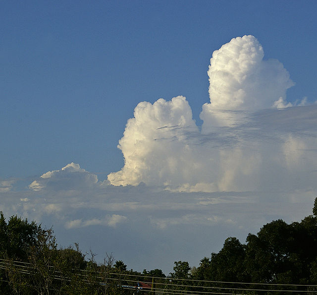
16 minutes ago, Zak M said:The cloudscapes here in Leeds are looking quite convective.

-
21
-
36 minutes ago, ResonantChannelThunder said:
Looking ahead, ECM is teasing with a nice looking plume in 8 days' time. Only mentioning it as it's been shown on both of its most recent runs rather than being a one off
I saw that! Total FI stuff, but as I recall there was a huge MCS that engulfed most of England in that run.
-
3
-
-
2 hours ago, Snowycat said:
Is the storm potential still around for Friday/Saturday or is it looking more like a lame duck end to the hot spell? There have been knowledgable opinions on both of these scenarios over the last few days.
I do enjoy the spectacle of a good storm although admit to hiding under the bed clothes if it starts to get a little violent
We had little or no thunder last summer to speak of and nothing at all so far this year.
In my unprofessional opinion it's too early to tell. The models all tell a different story. In particular, the GFS varies from run to run in terms of its CIN chart. We know that capping plays a huge role in setups like this one, so it might be an on-the-day job once there's more certainty as to likely affected areas.
-
2
-
1
-
-
Bognor looking pretty spicy at the moment:
Bognor Regis WestCam - Live webcam view with sound of West Beach Bognor Regis
WWW.BOGNOR.TODAYBognor Regis beach live webcam from the Pier at Bognor Regis, West Sussex UK. Live HD streaming webcam view of West Beach looking towards Aldwick, Pagham and Selsey.-
1
-
-
17 minutes ago, Jamie M said:
Thank you mate, trying to keep it simple otherwise my laptop will throw a hissy fit!
Yeah that's top drawer Jamie, nice one - saves having to scrabble around these nonsense webcam sites if it all kicks off. Good luck, hope you get a pelter!
-
2
-
-
Highly unlikely - a thunderclap is around 120dB, with 150dB required to shatter eardrums.
Noise Comparisons
WWW.CHEM.PURDUE.EDUAny prolonged exposure to 120dB is enough to damage hearing - the tinnitus you get after attending a loud gig is a consequence of this damage. However, the nature of the damage tends to be that it builds over time, and results in degraded hearing and tinnitus later in life, as opposed to the immediate and catastrophic impairment that you describe.
-
6 minutes ago, Cheese Rice said:
Just had a gust of 70mph.
Sorry mate, London or LBA? I live near LBA and it's a pretty standard Westerly gale right now - yellow warning is about bob on.
-
1
-
-
2 minutes ago, Dbarb said:
The BBC is now showing me 7 hours of winds gusting over 70mph approaching 80mph at times. Many trees won't be able to stand this
BBC is Meteoblue, right?
-
1 minute ago, Sainsbo said:
Possibly some further evidence of a sting jet on the AROME 0z: Vertical cross section shows air from ~800hPa descending to the surface collocated with the wind maxima.
Wow. Good find!
-
24 minutes ago, Liam Burge said:
Very interesting feature setting up here at 2pm on Friday. A few models have started to show a similar pattern to this.
This is the same feature two hours earlier on the AROME model on Windy.
Out of interest, is that abrupt 'wall' of wind and change in direction textbook sting jet?
-
2
-
-
11 minutes ago, weirpig said:
Latest UKMO few snapsots
Crikey, this brings Northern England right into the mix during rush hour. I'd expect the Amber to run all the way up to the Borders should this become more likely.
9 minutes ago, Marcus_surfer said:I'm travelling by train Friday at 9am to London from Swansea....its not looking good and I'm very concerned about traveling and the disruption
I'd put whoever you're meeting in London on notice that you may not make it if the weather's bad. I think the odds of that train service going ahead are <5% at this point.
-
2
-
-
6 minutes ago, Snowandrocks said:
There are differences in the building standards across the UK. There are standard exposure maps that are used to try to make sure the houses are suitable for the conditions they are likely to experience.
Practical examples include
1) It is standard practice in Scotland to fully board out the roof with sarking boards before attaching slates or tiles. I believe in England they just use battens. The sarking stiffens up the whole roof structure.
2) When I recently ordered some roof trusses, they asked for my postcode so they could engineer the strength of them to suit the likely maximum snow load. In my instance, the trusses were pretty substantial as I'm halfway up a North facing hillside in Aberdeenshire!
That's really interesting, thank you for the insight!
-
1
-
-
5 minutes ago, matty40s said:
Older houses, and houses Oop Norf are built to stand the conditions, darn Sarf, especially all these new thrown up housing estates, its not built as well as it doesnt need to be on a normal basis. Indoubt climate change figures highly in the planning of housing estate profit margin management.
I was wondering about this. I would expect that a Hebridean shepherd's cottage can withstand a lot more than a newbuild in the Fens, but is there anything codified in the building codes as to what level of resilience is standard?
-
57 minutes ago, joggs said:
My daughter is flying back from Krakow to Leeds Bradford at half nine tonight.
Has anyone got any experience if I can expect a diversion?
Tia
I live near Leeds Bradford, and it's bloody blowing, I tell you.
Open to correction from aviation anoraks here but it's blowing straight down/up the runway, I think the limits on headwinds/tailwinds are much tighter than they are crosswinds.
-
1
-
-
52 minutes ago, Atmogenic said:
My friend from Aberdeenshire is saying that buses are cancelled, 3hr waits for taxis, his work place is flooding with the lights flicking and car alarms are going off.
edit: now he has seen some smashed cars
I appreciate it's not your mate's fault, but in general the blasé attitude to weather in this country is ridiculous. In my opinion, a Red warning should be grounds for all non-essential workplaces to close for the day.
-
1
-
-
8 minutes ago, mike57 said:
Looking at predictions for wind speed / gusts on here Berwick-on-Tweed looks to be in the firing line for the worst of it currently, I have never seen 90mph+ predictions before. We are right on the edge of the Amber warning here, and I think the exact track is going to make all the difference, a few miles either way is going to be the difference between a big impact event and a typical winter gale.
This is exceptional stuff, there seems to be model agreement for 90+mph gusts too.


Storms and Convective discussion - June 2023
in Storms & Severe Weather
Posted
Yep, I saw the top of the cell that's over the North York Moors when sferics began around Castleford. It had a cauliflower top, and wasn't making any effort to flatten into an anvil.