


coldcomfort
-
Posts
1,525 -
Joined
-
Last visited
-
Days Won
10
Content Type
Forums
Blogs
Gallery
Events
Learn About Weather and Meteorology
Community guides
Posts posted by coldcomfort
-
-
1 minute ago, fergieweather said:
True (as 2013 attested). Indeed, as the UKMO 3-month outlook (issued this morning, to ensure proper assimilation of the ongoing stratospheric developments) alludes, re overall temperature signal from late Feb into/through March.
Why am I not surprised that the start of meteorological spring will probably bring the best chance of widespread wintry weather...as I said yesterday in the moans thread, the line on the UK weather headstone will read ' right synoptics, wrong time of year'
-
 6
6
-
-
2 minutes ago, Man With Beard said:
Not been able to post much recently but a small window now, so here's my assessment.
Forecasting on here comes in two types - what could happen, and what probably will happen. Singularity is doing a fantastic job in flagging up some of the longer-term "coulds" - keep them coming please! - personally, my level of long-term forecasting expertise is pretty close to zero, so I'm left to say what I see in the models.
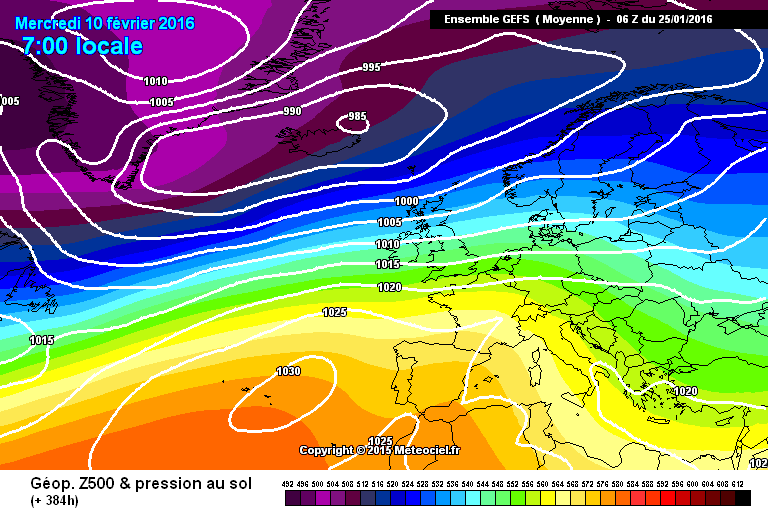
GEFS T384 mean

Not a surprise to see the Azores High in that position, but 1030mb sits off the coast of Portugal for more or less the entire run.
Highest uncertainty is over the UK from T240 onwards - looking at the ensembles individually, I'd say that's more down to timing issues of pssing lows. More importantly, fairly low uncertainty with regards troughing to the north, so very little chance given of a height rise to our north in the next 15 days:
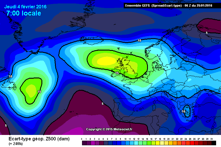
ECM ensembles for London - trending a little cooler in the D10-D15 period, but this is probably explained by the GEFS charts - passing lows, temporary WNW flow after the exit of cold fronts causing fluctuations between mild and slightly below average conditions - not properly wintry at least in the south:
And so this takes us out to the 9th February. Verdict - seeing any snow at all south of the Pennines and below 400m would be quite a surprise. Instead, we have a fair amount of rain:
and the odd gale, though nothing too extreme likely away from the far NW
Now it seems everyone is looking at the mid-February period onwards. Some of our top long-range forecasters (or those with access to long-range models) have banged a bit of a drum about the prospect of a cold flip around this time. We need caution here. Predictions at D20 and beyond can only be categorised in the "could happen" category. I caution anyone against putting them in the "will probably" category.
The truth is, if we get to February 10th in the way it seems we will, we will still be in need of dominoes falling in a favourable fashion to get a proper cold snap to the UK. And of course, if the charts are still zonal on February 10th, even a change in pattern may require an extra 5-10 days to filter through to the UK, taking us up to February 20th - and by that time, synoptics are increasingly required to be optimum to get cold/snow to our shores.
So my verdict is - I don't rule out the possibility of wintry weather returning to the UK - but if I was forced to say one way or another, my feeling is 60:40 that many southern areas may again miss out on proper wintry cold within the optimum winter period - those lucky enough to have seen snow last week may have scooped all in the prize fund. Further north may get lucky on a weak PM shot, but don't expect anything white lying on your ground for too long. Sorry.
Great post mwab, but quite why you or anyone else feels the need to apologise just for saying things as they are is kind of weird....unless you have a weather machine and have deliberately set it to 'mild til March' that is....
-
2
-
-
25 minutes ago, snow freak said:
yes I am sure that knowing the way the UK weather patterns go we will start getting the right 'cold' patterns appearing in April/May, when they are no use to anyone and we will have a cold spring which will just be an extension of what we are experiencing now. Why the UK always produces what we want, but at the wrong times of the year is just so annoying. I give up with this countries weather now.
Indeed, if ever there was a sentence that perfectly encapsulates things for the UK it has to be' right synoptics, wrong time of year' During May/June will will almost certainly see N winds progged to blast down across us at T+240hr and come the day there will have been no eastward correction whatsoever, meaning we will find ourselves directly under a 400 mile wide sausage of -5c 850's, that stop in the middle of the English Channel and then helps pump +10c 850's back up into Iceland. The UK has always had what I would call a largely 'uninteresting, climate, unless of course wind and rain is of interest then you are in Nirvana, but from what I can see unfolding the current changes are only going to make things even worse...if that is possible!
-
1
-
-
Winter is over imo....there I said it, not to grind folks gears as I'm sure will be the accusation, but because I genuinely think it is.
-
1
-
-
5.4c plz
-
1
-
-
Still some positivity re a change to cold come Feb in the MOD and it must be said plenty of it floating around on social media, but having just looked through the full overnight suite I'm still struggling just as much as ever to see why.
-
26 minutes ago, Certain kind of fool said:
it is disappointing really. I've absolutely loved the last couple of days - hard frosts, beautiful crisp, clear sunny days, stunning fiery sunsets...now back to the same old bilge water we had before Christmas. Given the excitement initially generated of "tanking NAOs" and "shredded vortexes" etc it was a pretty run of the mill cold snap. Just shows you how far we've fallen in recent winters!
No point in February if it's going to be grey, mild dirge. Roll on spring....and the inevitable below average, wet and windy second half of April/all of May.
Very much so...the spell that initially promised so much actually delivered very little, though anything was welcomed and the fact it emerged pretty much out of the blue has to at least give some encouragement going into Feb. Personally I'm a fan of first half winter cold, when the long nights give us a good chance of seeing some bitter weather, I find come Feb the much longer days mean the synoptics have to be that much better again to deliver... plus once it's light until almost 6pm you get the feel of Spring if it's sunny, almost regardless of the temperature. Hey ho, there's always winter 16/17 to look forward too
-
4
-
-
Good one Knocks....
Well the overnight runs if correct pretty much kill off any hope of cold before months end, so now we turn to Feb and the first thing to be thankful for is there are 29 days of it this year
Whilst none of us can be sure what Feb will deliver the MOD is a good place for at least gauging the mood/expectation, not just by the posts in there, but also by the number of members watching/posting. Currently the number is pretty few by comparison to recent days, but perhaps most telling of the mood is a post made 1/2hr ago that states 'GP said a few days ago anyone thinking a mild shot early Feb might be in for a shock'...the 1 like so far for that post pretty much says it all imo.
-
Well having perused all the latest available data, I conclude the hunt for Nessie would probably be easier and more fruitful than the hunt for cold atm. Clearly things can change and I very much hope they do asap, but I can't help thinking that fabled torpedo might well be away and running, but it's guidance system has failed miserable and it's now rapidly heading back in our direction.....INCOMING!!!!!!!
-
14 minutes ago, I remember Atlantic 252 said:
06Z not far away from record breaking warmth, similar to Feb '98, won't let me post charts bug on forum?
Indeed.....were the 06 to verify I don't think a 15 or even a 16c would be out of the question next week across sheltered E or NE areas. Frankly if we can't have the cold, then record breaking warmth that is actually accompanied by bags of sunshine rather than ark building levels of rain will do as a substitute......but of course knowing our luck it will only lead for a very blocky, cold Apr-Jun
-
06 GFS shaping up to be even milder at 168hrs - Euro slug back in position, double digit highs for most, but on the positive side plenty of dry weather in the offing. Looks like a long route to cold from there if it verifies and with only 5 weeks of official winter left it don't look too pretty imo.
-
14 hours ago, northwestsnow said:
Finish off winter?
LOL.
Whilst it's always easy and indeed popular to laugh off suggestions such as winter is over with 5 or 6 weeks to run, the latest ECM32 suggests if not probable, it's certainly possible. The overnight runs hold little if any hope of an imminent return to cold after tomorrow, with the long draw SW'erlies likely to produce some double digit maxima for most of us early next week. By the time the next 'milder' phase is over we will imo be well into week one of Feb, meaning only another 3 weeks of official meteorological winter will then remain....so to suggest those 3 weeks won't produce a notable cold spell doesn't seem too much of a stretch to me....though hopefully that will not prove to be the case.
-
1
-
-
2 hours ago, emotional rollercoaster said:
I think you should post more often because the models are forever making me look stupid but hey that's why model watching is so addictive especially lately best charts popping up since 2013 09/10 so 1 easterly for 1 day with snow id be happy.
theres fair few models with same sort of ideas so theres every reason to be quietly confident although my sofa has bald patches well so do I after recent ups and downs.
but no need now for a pattern reset lets see if the current pattern will build into something a little special its happened before and will happen again at some point.
infact was it not feb 2013 that was a feb cold spell that continued into march.
my dad said the other day winter used to be from jan through march back in the day.
Definately an interesting 06 GFS, perfectly highlights how just one or two minor tweaks are needed to give a very different look to things, but if ever there was a case of 'more runs needed' then this must be it!
-
Well the GFS is now starting to churn out the next lot of post T+192hr eye candy and the cold chase is off and running once again in the MOD. We've already seen the first 1947 comment, standing by for more of those in the thread - no doubt liberally peppered with some 63 and 10 stuff, as per. This last cold spell looked significant 7 or 8 days prior and to be fair it eventually delivered at least something, but it really didn't come close to matching the potential shown...perhaps this next one will, perhaps it might even upgrade as time goes on, surely there has to be a break in the almost perpetual cycle of downgrades at some point...fingers x'ed!
-
2 hours ago, northwestsnow said:
Hmmm you might want to revisit that post , FAX charts say cold until later in the week as opposed to early in the week
Indeed, I did call it wrong. However I'm not the first to get a forecast wrong and I'm pretty sure won't be the last, so imo you are being a bit unreasonable...unless of course you intend to point this out out to each and every poster, each and every time they err?
-
Normal extreme straw clutching going on once again in the MOD, just can't be bothered with it tbh. Thankfully in here things are often looked at rather more realistically and the 06 again finds no trouble whatsoever all displacing the cold early next week....negative tilt, my arriss!
-
6
-
-
Just seen the BBC forecast for Sunday and sadly it franks the fact GFS now looks set to be right all along with the timing of this breakdown, despite all the other models saying something different and all the other usual suspects (experts included) trashing it virtually every 6 hours...pretty much as per. This one now looks to be an epic fail by the MO, who only 12 hours ago were calling for a sparkling weekend nationwide and now have rain and sleet across much of the northwest on Sat, a very much warmer night to follow, then widespread cloud and patchy rain/sleet for Sun. Given all at their disposal and a timeframe of only 48-72hrs, I find that very, very poor indeed.
-
1
-
-
UKMO 144hr is proper eye candy this evening, but without some sort of support from ECM I'm not sure it can be taken too literally. As for the 12 GFS it is again nice to see a move towards an undercut, but unfortunately it does nothing other than delay the onset of milder southwesterlies, which I really can't get too enthused over at this stage. As ever more runs needed, starting with 12 ECM in half an hours time, but if it drifts too far from it's 00 counterpart I will be surprised.....pleasantly so however
-
1
-
-
That is my point, one persons rather cold is another persons raw, one persons bitter is another persons chilly. So rather than trying to tell people how they may or may not feel, would it not be better to just stick to the facts, or if that's too difficult then just stick to one description and not use 4 or 5 different ones in the same forecast.
-
1 minute ago, northwestsnow said:
Not about that cc, more about the gfs moving towards the UKMO
Agh OK, thanks nws, tho I must say it doesn't look hugely different to me, just normal variances.
-
1
-
-
15 minutes ago, Steve Murr said:
GFS 06 out to 66- already more incremental swings to the UKMO in terms of amplifcation-
I will post the 126 00z V the 120 06z for comparison...
s
I'm confused here....I thought you didn't rate the GFS and had even less regard for it's 06 output, or have I missed something?
-
2
-
-
Perhaps it's because I'm a bit long in the tooth, but back in the day when TV weather presenters used certain words to describe certain types of weather the words used were generally A..accurate and B..consistent. So when Jack Scott for instance said it will feel bitterly cold and raw, do you know what? It felt bitterly cold and raw, end of!
These days it seems all words/terms are up for grabs, with the local BBC forecast this morning discribing today as bitter, chilly, cold, rather cold and raw, all within the same 60 second output. With maxima around 7c, or close to average if you prefer, I think feeling cold in the wind pretty much covers it, but it appears the need to over sensationalise and in turn utterly confuse knows no bounds.
Clearly some will find today bitter, some will find it raw, some rather cold and others chilly...no doubt some will even find it quite pleasant. To my mind trying to be all things to all men is where this is going wrong (and getting worse), surely it's better to use temperatures and where appropriate windchill values to make the forecast and allow others to decide how it feels on a personal level.
Discuss....
-
1
-
-
Well if we thank back to what the models were showing a week or so ago things look decidedly poor from a cold perspective, indeed if this had been a normal winter so far the up coming spell would have barely warranted mention....normal or a little below looks about all the vast majority of us can expect, so wooopy doo!
Going forward hope seem to be pinned on the UKMO, but lets be frank hopes are always based on the coldest model, with the return to milder weather early next week being touted by both ECM and GFS far more likely to verify imo. Beyond that it's good to read the latest ECM32 keeps high pressure close to the UK, so hopefully a much drier 2nd half of winter looks feasible, but as for any significant cold...well no doubt we will have to wait until April/May/June for that balance to manifest itself.
-
3 hours ago, stainesbloke said:
Well it won't be raining constantly like it has been these last couple of months so that'll help start to dry things out a bit. It would be good to get a dry feed from the east like you say and it doesn't look like a return to SW'lies anytime soon. I'll happily take the cold high showing up now, as long as it's sunny! High pressure in itself feels like a novelty.
I agree re high and dry SB, just hope it happens, but once again the 06 GFS just won't lie down regarding a return to milder and ultimately wetter Atlantic air this w/end...expect it to be another overly progressive outlier though.


Model output discussion - 21st Jan Onwards
in Forecast Model Discussion
Posted · Edited by coldcomfort
Definitely a more 'encouraging' ECM this morning regarding the potential for a colder pattern, but given it won't be the first time it's flagged something like this post T+144hrs this winter, I think caution very much remains the watch word - especially in view of the fact GFS once again doesn't want a bit of it. UKMO also looks pretty decent at 144hrs, but again it has done so several times this winter, so I'd personally like to see something similar at T+96hrs from them before getting the warm coat back out.