


tesaro
-
Posts
95 -
Joined
-
Last visited
Content Type
Forums
Blogs
Gallery
Events
Learn About Weather and Meteorology
Community guides
Posts posted by tesaro
-
-
27 minutes ago, yamkin said:
Take that forecast with a pinch of salt regarding no snow being shown
Bit of a Funky forecast that. She said that temps would struggle to get to 4 degrees in places Thursday and then goes on to put a temp of 6 on the outlook. This is really starting to remind me of 1991 but with a tad colder uppers. I remember driving to work when it began. There were snow grains wisping along the Road in the increasing wind. It kicked off the next Day as the colder temps moved in. Constant Snow for 2 Days. Not always heavy but it all added up to over a foot. Drifting was the main problem due to the Powdery nature of the Snow. It was mostly over by the Weekend but stayed cold for a good few days after. What is being forecast looks like an extra couple of days on top of that and very possibly more. If you like mild Weather I think you may be a tad depressed by the end of the Month.
-
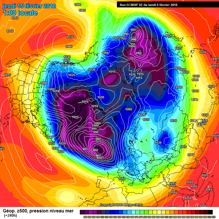
56 minutes ago, David P said:
 I am am starting to sit up and take notice of what the models are starting to show now. I have model watching and lurking on here for more than 10 years and I love it, even when it all goes wrong (a bit odd I know). ?There have been some epic climb downs, particularly in the last 5 years or so, by the models there ain’t one of them that is perfect!???
The image above is about as strong a signal for cold as we will ever see for London. Like other members have alluded to this, if modelled correctly, is likely to be longer lasting than the February 2009 event which only had -10 850’s over us for about 24 hours. For me this is was the best snow on the ground event in zone 1 since 1990-1991.
Might seem a bit IMBY this post, even though this winter I have seen snow on 10th December in Buckinghamshire when we almost got stranded.
And more recently on the 6th of February whilst visiting family in Scotland with snow covering the majestic and beautiful Ochil Hills.
I really want this to come off for us snow starved Londoners, the children of zone 1 should get to build snowmen too ❄️☃️❄️☃️❄️☃️❄️☃️ Cross everything ??
Unfortunately with the forecast Temps and continental dry air, Snowman building will be difficult. Dry, Powder Snow. Kills off Trains pretty fast if I remember correctly. The wrong kind of Snow
-
35 minutes ago, Catacol said:
Musing about Feb 15. Amy Butler has tweeted an expectation that the SSW of Feb 12 will begin to force storm tracks equatorwards after about 3 days. This is the ECM for the start of that potential process
I'm seeing very cold air dropping into the mid Atlantic with pressure rising to the north and Scandy pressure also I suspect on the rise. Storm track set to shift further south as impacts of the reversal are felt and cold begins to tumble southwards.
Is this the precursor to the mother of all undercut scenarios?? I wonder what ECM would look like for weekend of 17/18. A bit of southerly adjustment and this would be the biggest blizzard since... well.... the last time we had a big blizzard.
Hmmmmmm.
You know I was just thinking the same thing when you posted that! I know most peeps on here like a bit of the White stuff but if that frigid lump of Vortex got south of the UK I don’t think you would see your Daffodils until the Bluebells had finished flowering.
-
West Suffolk calling.
Clear sky after midday Rain shower
Temp 3.1c falling
Dp 1.0 c falling
Wind ENE 10kmh gusting 25kmh
pressure 1019 falling
Dog somewhat stinky after a dip in the Stour
-
4 minutes ago, Tanden Sparkster said:
As a Southerner living up in the NE, your talking alot of cobblers. Oh and when it comes to Sun, western Scotland has on average the highest amount in the UK. Please respect the forum and do your research before you comment Cheers.
It actually Bognor and the far South.
-
 1
1
-
-
14 minutes ago, Skyraker said:
Something is most definitely afoot.
i really think we are about to see something very special over the next two three weeks.
The models just don't know what it is yet.
I’m in the same Camp as you. Have seen this sort of setup before. Watch the Highs puff up to the North in the coming runs. The Azores High could soon be a very good friend of ours.
-
Nice clump of showers coming into Norfolk. Look to be heading Cambridge/Newmarket direction. Wonder if they will make it far inland?
-
I think maybe a better than 30% chance of Snow falling . North of London with some elevation say 100mts or so should at least see Snow falling . Wether it settles at all depends on ground temps, intesification etc. Difficult call for lower ground further South but certainly not out of the question. Had a heavy shower of hail here earlier which took 2c off ot the air temp in no time , albeit tempory.
-
Its raining here in west Suffolk. Capp gone it seems.
-
1
-
-
Looking at the way this is deepening and it's present track, I would eat my hat if Heathrow get anything as severe as 90mph. As it moves out into the North sea later this morning the Nwly behind it could be severe so Mayby Stanstead may just get near.
Essex, Suffolk and Norfolk plus perhaps parts of Kent may not bear the brunt of this but I would expect these areas to record some of the biggest wind values as the system exits. The sting in the tail could well be what hits the headlines.
-
1
-
-
Right warnings fully updated so here's what we have now Amber wind warning Wales, West and East Midlands, London and South east, south west England All other areas not listed above have no wind warnings at all with the yellow warnings removed Rain warnings North east and west England, Yorkshire & Humber, West and East Midlands, south west England, Wales And not forgetting the east.All other areas not listed above have no rain warnings
-
Still 28.4c here in west Suffolk at 21.30.
-
Just reached 31oC here between bury st edmunds and Haverhill West Suffolk. Atmosphere still stable but very humid.
-
Current temp 22.2c here in west suffolk and a beautiful clear blue sky.
-
Cloud sheet lifting out here too in West Suffolk. Wind picking up and looks like some late sunshine. Few showers beginning to pop up close to here too.
-
Interesting Radar up in the North sea around Hull. An area of convection from the sea colliding with the weather front from today. Someone up there is going to need a shovel!
-
I know were all concentrating on friday/sat's snow band and how far east it may get but the convection opportunities are looking excellent for this region for later in the weekend and beyond. Looking like there could be some real beefy showers about spreading well inland at times too. We have all see in recent days especialy those in north norfolk what a snow making machine the north sea can be.
-
3.8. Cold slowly building through the first half of the month leading to a memorable last week/first week of Feb.
-
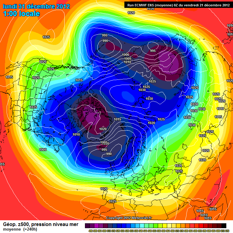
Have to say the medium range is looking rather disappointing to me.
http://modeles.meteo...-21-1-240.png?0
http://www.meteociel...1-240.GIF?21-12
So it seems we shall have to wait until we are into January before any significant cold spell could affect all of the UK. However despite all the promising teleconnections/stratosphere predictions I would advise members to be cautious until this actually appears on the model output. Another reason why im saying this is the Met O predicted the 2009, 2010 cold spells from some distance away and yet their 16-30 day forecasts continue to suggest more of the same i.e zonal. So whatever positive signs some are detecting on here the Met O don't agree.
Dave. Remember back in March this year. We were in a drought situation. I remember well the meto 30 day comments regarding a continuation of the dry conditions as i had plans to do some major home improvements. So i gave them the benefit of the doubt after there "BBQ Summer" washout and preceded to remove the roof from my garage.
Met Office 3-month Outlook
Period: April – June 2012 Issue date: 23.03.12
SUMMARY – PRECIPITATION:
The forecast for average UK rainfall slightly favours drier than average conditions for April-May-June as a whole, and also slightly favours April being the driest of the 3 months.
A few regrets a month later as im sure you remember.
This month is the UK’s wettest April in records dating back more than 100 years to 1910, the Met Office said on Monday.
They don't know whats going to be happening in 30 days time. They may have a computer the size of my flooded garage but its only as good as the human data thats fed into it.
-
At least they suggest a more southerly tracking jet. So room for some changes, whats a couple of hundred miles globally?
My optimism rating has recovered to 6/10 after falling through the floor after the easterly fiasco!
So Nick, going by the latest charts are you going to show some leniency towards the Russian high or is it still on a two day countdown of usefulness?
-
I see the METO have decided to go with the flow with their updated winter forcast. Their long range views on things have changed quite starkly!
With regards to percipitation on the upcoming cold spell, dont look too far ahead. Things do tend to pop up out of nowhere. The faxes are your best friend for these.
-
Contrary to the met office predictions, I am predicting some snow in the next couple of hours for parts of Norfolk, and eastern areas of North Suffolk. So there.
Yes iv'e been following that intensifying band headind towards EA for a while now.
-
Has been an interesting day here in EA. Started out at 8am and ran into a thunder storm just south of Royston Herts. Going from there to Peterborough then down to Cambridge i was under thunder and lightning constantly for over 9 hours. Van is nice and clean now though. Has been pebble dashed, thoroughly rinced and topped off with a nice natural sun dried finish.
-
Quick report from here in West Suffolk. Just measured 7.5" in my back garden. Seems to be some kind of North sea streamer event with south Cambridgeshire being the northern extent.
As for the snow forcast for later on, dont even think i will notice the front arrive. It could'nt snow much heavier than it is at the moment!
If anyone wants pics from here feel free to ask.
Ray


SE and East Anglia general weather discussion 11/02/2018 onwards
in Regional
Posted
A straight Easterly is fine for most of East Anglia as long as the wind has a bit of Omph to it. showers will be blown well inland from the North Sea and with a greater Sea track than areas further South can often be heavier and more prolonged. If the wind turns South of East then area to the south gain what we loose. As it looks on the latest UKMO chart we will all get more than enough.