


Snowy Hibbo
-
Posts
136 -
Joined
-
Last visited
Content Type
Forums
Blogs
Gallery
Events
Learn About Weather and Meteorology
Community guides
Posts posted by Snowy Hibbo
-
-
My final long term forecast for the season for Europe, and my seasonal forecast verification:
https://longrangesnowcenter.blogspot.com/2019/02/europe-on-long-term-23rd-feb.html
Looking like a +NAO zonal setup is likely into the month of March. This means the U.K. might start to see quite a lot of precipitation in the first half of March, and potentially beyond.-
 5
5
-
 2
2
-
-
- Popular Post
- Popular Post
Here is my thoughts for the snowfall situation in Europe. You can assume that a -NAO setup will be ideal for a snow lover in the U.K.
https://longrangesnowcenter.blogspot.com/2019/02/europe-on-long-term-2nd-feb.html
"All and all, the models show a increasingly snowy Northern Alps. But I expect a -NAO setup in the last two weeks of the month and into the early days of March, that tends to support the Southern Alps (and the UK) in terms of snowfall and building troughing scenarios. In the medium term, we should see an atmosphere conducive to snowfall across the Northern Alps, and perhaps as we move forward, more so towards Austria, at least expect more cold there if anything."
-
8
-
2
-
https://longrangesnowcenter.blogspot.com/2019/01/europe-on-long-term-jan-19th.html
An extract from my latest long range outlook below.
"My overall view is that from the last week of Jan to the second week of Feb, will feature major snow risks for the Southern Alps and the UK. There will be plenty of cold around, but not so much snow for the Northern Alps. We should see a neutralisation in the later stages of the month."The outlook includes my thoughts on the GWO (click image below), and my thoughts on the latest EPS 46 run.

-
8
-
-
12 minutes ago, Radiating Dendrite said:
Snowfall? In Scotland but that is not unusual for November. Anyway, not going to argue the point anymore.
-
6
-
-
14 minutes ago, Radiating Dendrite said:
Think you are moving the goal posts a little there. November was not cold in Europe no matter the definition used.
2 minutes ago, Seasonality said:So in other words you make up a definition to fit your statement Very 'alternative facts' Meant in the nicest way possible.
I am not shifting goal posts, I'm saying that several troughs which brought snowfall to parts of the UK, which doesn't happen very often, and they brought some cold. Perhaps it did average out to be warm, but my point is that November featured more "interesting" weather, than December.
-
8
-
-
6 minutes ago, daz_4 said:
I don't think that's true.
Anyway, GEFS slightly better but it will be a long countdown to 20th.
In this age of AGW, cold in the way I described it is more like smaller very cold risks contained in a 10-20 day period, rather than a whole month. Plus the +AAM impact would have been like Nov 20 - Dec 10, not the whole of November. Cold is also a relative term, not to the climatology set long ago, but to the current climate and landscape. All IMO.
-
5
-
-
- Popular Post
- Popular Post
2 hours ago, Rapodo said:Have to admit I'm totally shocked with what we have on offer at the moment. There was high expectations given all the background signals this winter and absolutely nothing to show for it. For me though I've learnt a BIG lesson this year not to trust the background signals or get overly excited when there is sudden reason to ramp and then nothing happens. Will take everything with a very large pinch of salt in the future now and will certainly keep expectations to a minimum. Think we can all learn a good lesson from all this not to get to carried away over certain events and output.
What. That's an incorrect lesson. It's like going backwards.
Take November for example. There was a high +AAM orbit in the GWO, and it shows it to that effect. And guess what the UK got....
GFS +6h forecast from the 21st of Nov 2018.
The UK got a period of anomaly colder temperatures. We saw a -AO and -NAO from MSLP levels (not so much from upper fields). We saw westerly momentum coming off the NA Continent, displaced by the Atlantic ridge/-NAO setup to create this event, as perfectly as it came.
November was remembered as cold for both the Eastern US & Europe. But if you look at what happens in December, it goes to low amplitude cycles around the COD, so you would expect a more neutral effect, that would be created by the +AO type of atmosphere to be not so good, as we have seen.
So now the GWO is coming around (remember there is a bit of a lag too), we should expect cold associated with Phase 7 GWO in the next month, as these impacts are in feedback with the SSW, and take time.
So basically the disappointment has been created by the ramp up of modelling and signals like the MJO, rather than the actual state of the GSDM. Keep your expectations calculated, and you will see success.
2 hours ago, TEITS said:Nothing to do with luck. If we do not see any cold weather this winter then obviously the variables that dictate our climate were not favourable and those variables were misinterpreted.
Very disappointing output. Just when we were hoping we may see some form of blocking/Cold Spell to hit the UK around Mid Jan, the models are currently suggesting the reverse with an unsettled outlook looking likely with gales. The most disappointing aspect is I see nothing that suggests any form of blocking will develop towards Greenland, infact the complete reverse!
And this attitude doesn't help as well. You place doubt in Teleconnections, and then you proceed to place all your forecast in the hands of models that have low verification.
This verification that shows GEPS, GEFS and EPS all in one verification chart at T+360. Predictive correlation values fall below 0.2 at times, for both EPS and GEFS. And we are currently in one of those lulls in verification, given the SSW and AAM factors.
There is higher verification in the forecasts Tele experts put out, than GFS FI, simply put. This is because one is NWP, and can't see everything amongst bias, and other factors. And the other is a comprehensive model that explains how the momentum and winds circulate around the world.
-
21
-
1 minute ago, Leo97t said:
It is once again looking poor. It seems the better the background signals are this winter the worse the outlook gets. Maybe it's those SSTs. Never believed in that theory but maybe it holds true...
Patience....
The background signals will come through, maybe not as one may expect. It's not like there is some secret magical mechanism that could make the weather worse than the signals suggest. It's a symptom of overreliance of NWP.
-
6
-
-
- Popular Post
- Popular Post
4 hours ago, jules216 said:MJO Phase 7, split vortex, GWO phase 5-6 and this is the result. A Far cry from UKMO and ECMWF seasonal models from their initial cold updates. once again it proves that NAO is the wild card and has failed to go negative despite plenty of positive background signals. UK/IE is once again going to look at FEB/March for winter to arrive.like most recent climo
Relax, all good things come with a bit of patience. NWP is not going to grant one a solution that features colder risks, because it's confused between the AAM amplification and the SSW impacts, which are slowly developing due to downwelling. It will come around. The latter half of the month should still be better.
I just produced this post on another forum, that may help explain why I am feeling this way.
Yes the more Nina-esque than expected tune through December was certainly not expected by me, with the +AAM being pushed back to New Years as it is now, but it is fortunately now here, and we are seeing impacts with the NP Jet extension in the next week or so (more on that further down this post).
The low orbit of the GWO positive phase, that we are in, is because the relative AAM anomaly is low, with a substantial contribution from Earth AAM, contributing to the total AAM.
The big November (as far as I can see from Australia) was largely generated by the +AAM.
We saw that unprecedented spike in the AAM in the majority of November. But then you see that smaller +AAM spike from 5-15 Dec, and then now the current (total AAM) +AAM spike, which is nearing the level produced by the +AAM spike in November.
The difference is what is driving it. Total AAM, sees relative and earth AAM combined, unlike what is seen in the GWO charts, which just have relative AAM. There is probably a reason for this (torques cover earth AAM?, it doesn't effect the Total AAM often, etc.), but it just shows that the GWO chart can't see absolutely everything, so should like every tool we use to forecast the weather, be examined with all of the GSDM tools that we are provided. But of course I'm not denying it's a good tool, it can see lots of things that the MJO, and the favourite the SOI cannot, but not everything.
If we look at the relative AAM, you see the November spike, but a much lesser +AAM spike now for the current +AAM, and very little sight of the +AAM event from 5-15 Dec.
.
Earth AAM after months of stable neutrality, produced a relatively strong +AAM for the 5-15 Dec event, driving that total AAM spike. And now it is producing, alongside relative AAM, this large +AAM spike. It's very interesting to see this component come into play.
The other thing I would like to add, is that I think this +AAM event will still produce what is intended (colder impacts for Europe and Eastern US), later in the month, along with when the SSW downwells into the troposphere IMO. We need to see the extra momentum, and then get the troughs into the extratropics (via SSW > -AO > HLB). Then the AAM can drop, jetstreams can drop a little and that is when we see the real cold. The timing could be a little off, but the second half of the month should still be good for the Eastern US and Europe. Europe quite likes a +AAM/GWO P 6-7-8 in terms of colder risks IMO, with the jet to push away the block over the UK.
And you can see the +EAMT impacts are still on show well into mid-month, with a NP Jet extension, which will bring +PNA impacts after that extension weakens a little (without collapsing the Aleutian Low structure), and we see blocking in the Western US develop, and that brings troughing to the Eastern US. Along with the eventual -AO, downstream AAM effects will bring a -NAO later in the month.
And I think everyone also forgets that the MJO Phase 7-8-1 impacts for troughing in the Eastern US, and Phase 7 MJO impacts towards a -NAO, all have a lag, depending on the location of impact and the tropical signal. The MJO and NAO connection features a lag of 10 days for example.
-
14
-
2
-
https://longrangesnowcenter.blogspot.com/2018/12/europe-on-long-term-28th-dec.html
My thoughts for the European Alps and the UK over January. And it's looking good, depending on the impacts of the SSW. The MJO looks to be pretty amplified, like the GEFS forecast. And the AAM looks pretty positive over the first two weeks of Jan.
-
6
-
1
-
-
- Popular Post
I will also add my musings to @Bring Back1962-63's post, which was on the same US forum.
Just a few random musings from me.
As you can see to start, we have a +NAMT right now. Look at the ridging to the East of the Rockies. This demonstrates a +NAMT. This is what is creating the uptick in MT anomalies, which @Bring Back 1962-63 observed above. But what you can also see, is that this quickly dissipates, under the pressure of lower geopotential heights. The Aleutian Low in the very short term, is going to dislodge very quickly, under the pressure of an anticyclone in the Pacific, as well as brief NAO/B-K Ridging. It splits off north and south, with the zonal circulation taking the former Aleutian Low south into the CONUS, to create a -NAMT, on accord of the breaking down of the Aleutian Low structure in the Pacific.
It also creates/helps this beast, which I am sure is being well discussed in the shorter term threads.
This is basically to show that the -NAMT is the mechanism or at least the reality of lower pressures like this. You need a strong jetstream to build the pressure, but you need something to release it. This is the releasor for this particular event. The much stronger releasing factor in a fortnight will be the SSW and it's tropospheric impacts in the AO domain.
Apart from Days 5-6 which show more of an extension, it is consistently showing a poleward shift, which is due to the fact there is no low up in the Aleutians to keep the Jet down. But notice there is no retraction. The extension remains in place for the most part. You can see that in the 250hPa jetstream chart on Tropical Tidbits (not going to post pic, otherwise there will too many charts). It moves north, which will likely keep the steam train of snowfall events into the Pacific Northwest and British Columbia alive, and leave California and Tahoe rather dry in terms of precipitation and snowfall for the latter.
This means I don't think there is such a massive -EAMT trend. We will see more -EAMT anomalies distributed in the next 3 days, but that is followed by a +EAMT event on GFS on D4-5. Then another -EAMT on D6-7, then the current Eastern European/Barents-Kara Block dislodges over the next 7 days, and comes down as a strong Siberian High, and links up to bring another strong +EAMT event for a good 3-5 days, boosting the North Pacific Jet. The +EAMT pattern stays until the end of the GFS Determ run (Day 8- Day 16 period). So it starts from the 24-25 Dec period, so with a 7-10 day lag, PNA effects to occur from New Years Eve into the New Year.
Because it's so far out, it is hard to gauge the impacts of this with NWP modelling. Like do we get another Aleutian Low in the Xmas-NY inter period? Will it feedback loop with the developing SSW?
All I will say is that it what goes down, must come up again..... does that work
We should see the +AAM coming up again properly in the days leading up to the first day of 2019. I like something like the CFS GWO forecast below.
Perhaps it may be a bit stronger in terms of Phase 5 and 6 orbit, but similar progression and timing (maybe a tad earlier though, but it doesn't really matter). Linking up with the SSW, that should be gold for the Eastern US for snow lovers. With a Stratospheric induced eventual -NAO, probably good for Europe as well in terms of cold.
I will just continue the discussion quickly about the SSW. I don't think we will see a fully split Vortex, nor do I believe that a split matters in order to get desirable (snowy or cold) effects for the United Kingdom. We will see a technical SSW, and we will see very consistent w1 forcing, that will almost push it to a split vortex, but not completely. The options for genuine w2 forcing before the New Year are slim, and while I think there will probably be some sort of w2 forcing in January, as stratospheric alignments change, I don't think it will matter much, because the SSW, which will primarily take place in the next two weeks, will be pretty much done. There will be plenty of energy about in January (think +AAM), so there is an opportunity for sustained SSW conditions, which would enhance the tropospheric impacts, and would be the best option for an actual split. A displacement vortex doesn't typically bade as well for Europe, as it does for North America in terms of cold, but given the extratropical factors, I think a -NAO will develop and Europe will get it's cold. Maybe not record breaking, but it will be cold. The descending westerly QBO Phase isn't going to change these mechanisms much, it actually is climatologically linked with SSWs.
Takeaway from all of that is the UK will get it's cold, given all of the surrounding positive factors.
-
22
-
6
-
Zac Lawrence's new site is jam-packed filled with useful tools for the winter in the area of stratospheric forecasting.
-
8
-
-
Here's my thoughts on how the forecast will go for the U.K. (And the European Alps).
https://longrangesnowcenter.blogspot.com/2018/10/2018-european-winter-outlook.html
Including analysis on the MJO, ENSO, NAO, Arctic domain factors, etc.
-
4
-
1
-
-
7 hours ago, Steve Murr said:
Just to wrap a few more bits up-
Exert from twitter today showing the huge. - EPO ridge in September & how its POOR for cold / troughing on the east coast- its almost as of if they wrote exactly the same as me
WXRISK is Dave Tolleris - Professional Met.
Ridge on the east coast....
Just to close this down-
A shallow ridge in the EPO position with a weak dip in the jet will bring cold to central & Eastern Canada- & of course possible parts of the NE-
However as you increase the intensity of the high - so you modify the depth of the trough in terms of how far it digs south-
The more negative it gets the further west & south the cold moves, & in proportion the warmer air moves further North & east along the eat coast-
When we are talking about record breaking intensity the trough will be digging down towards Texas ( hence the mention of texas snow over that period )
The fallout being that the NE part of the US will be warm all the way up to even quebec & it supports a ridge along the coast - hence the enhanced -PNA...
So to prove your point, you show the tweet of a "professional meteorologist", asking whether the -EPO means cold. I am not quite sure about his credentials.... I would find someone else to prove your argument. And then the replier didn't support your opinion, he said it was "tough".
-
1
-
-
Quote
Whilst your post has some credibility in the fact that the margins of a -EPO high & +PNA high overlap - the loading pattern for a +PNA ridge is a much better teleconnector to an East coast trough than the -EPO ridge as the latter is located further west.
So what is this then?
Bottomline, whether the blocking is in the -EPO or +PNA domain, the downstream troughing occurs in Central and Eastern US, with the polar lobe coming down over the Mid West and bringing snow to the Mid-Atlantic/New England.
And this further demonstrates the downstream effects.
This is not to say blocking doesn't occur in the Eastern US, during a -EPO. I am just stating that a -EPO is correlated with a trough over the Central and Eastern US.
QuoteIn this scenario its 100% clear to see the troughs located in the Northern plains uo to central & you have a fat ridge on the east coast
That blocking over the Bering Sea isn't what I would call a -EPO, too much leaking into the Far East Siberian region, with the troughing off Western Canada too. That would be the WPO domain.
With a -EPO and +PNA pattern, the below graphic shows Eastern troughing, in combination with other factors.
Shows that there can be successful cohesion, which drives troughing on the Eastern half of the continent.
QuoteEven the teleconnection data shows your wrong
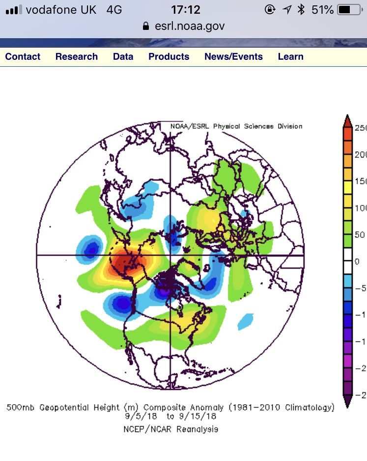
Reanalysis 28 Aug - 10th sept
Huge -EPO RIDGE in a classic Alaska location
Not an east coast trough in sight...
PNA metric
Here was the EPO during your period, first half dominated by a neutral EPO, then a weak-moderate negative phase, then a weakening of the -EPO towards the end. Meanwhile the -WPO was nearly off the charts in strength, so clearly you have picked the wrong domain. The WPO and PNA domains don't cross, nor often correlate. So your statement of "HUGE -EPO RIDGE" is quite misleading.
You also ignored the more -EPO like blocking from the 8-18 Sept this year, which was also a period subject to a +PNA.
-
7
-
-
4 hours ago, Steve Murr said:
The September pattern with the huge blocking high west of Alaska ( -EPO ) & the downstream trough over the central plains does not equate to a trough in the East- it encourages the opposite - A warm ridge in the East ( -PNA )
With all due respect, you are wrong. A -EPO's downstream effects often create a Eastern trough. That is what it is known for doing, disturbing the polar jetstream up to Alaska, and bringing cold down to the Eastern Half of the United States. A -EPO if it stretches down towards the West Coast of America often gets called a joint +PNA and -EPO. So the assertion that a -EPO must go with a -PNA or vice versa is entirely misleading.
-
7
-
-
5 hours ago, Catacol said:
Half way through October. Time to stir....
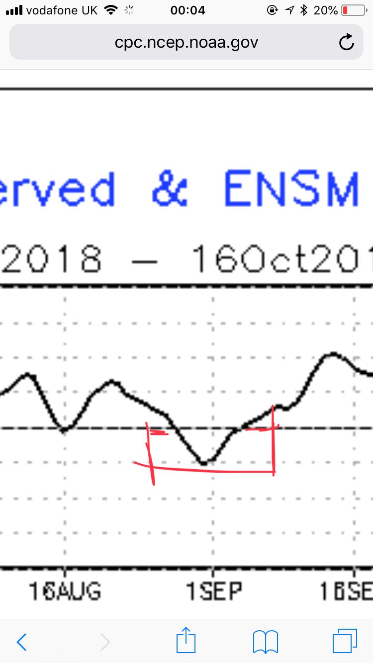
Interesting reading RJS's comments in the seasonal forecast thread regarding extreme cold in central Canada and likely downstream trough from this event. If this can be given as a base state heading into the start of winter, then exact positioning of the long wave pattern becomes guessable. Note the MetO ENSO forecast
As many forecasted several months ago we are heading into a weak Nino winter with consequent pressure applied to subvert sub tropical high pressure belts and therefore the possibility of a more southerly tracking or split jet. GLAAM is in a moderate to strong positive phase
and the Nino imprint onto the atmosphere is clear from the GWO state which has been locked into the 5 - 8 orbit for weeks now
For the foreseeable therefore a pattern that wont encourage flat westerlies, should instead see a good deal of jet wobble and curve, and an autumn that for now looks to remain fairly blocked. With an eastern US trough likely then the suggestions from a number of posters that a mid atlantic high may develop downstream looks about right to me in the context of the above. That might help to bring about a frosty and foggy passage into November.
7 hours ago, Singularity said:The pattern looks increasingly amplified during the next 10 days with some unusually strong mid-latitude ridging around. Ties in well with some strong MJO activity in the western Indian Ocean of late and with a recycle looking to get underway in the coming days (though GEFS way more amplified with this than ECM), though Arctic amplification is probably adding at least a little more to the ridge-trough amplitude; the situation is just crazy up north of us.
The MJO forcing will conflict with the current Nino-like state of the tropical Pacific SSTs - and in fact, it appears it (the MJO forcing) will be the more dominant factor, with the ridge tending more west of the UK during the final week of the month in a Nina-like fashion.
Meanwhile, there are signs of further WWBs to help those tropical Pacific SSTs rise further. A big ocean-atmosphere disconnect evolving - but how long can it last?
I realise I added to the case for an oceanic and atmospheric disconnect, but what if the ENSO is helping to signal, particularly with CP Nino regions being warm (along with EP Nino regions theoretically warming as well), and cold SST anomalies around Maritime Continent. This would help MJO and other equatorial waves to avoid Phases 4 & 5, and stay around Phases 7-8-1, particularly the former two phases. This is all for in terms of the winter, but can also apply to the present day.
-
5
-
-
On 10/10/2018 at 04:30, jules216 said:
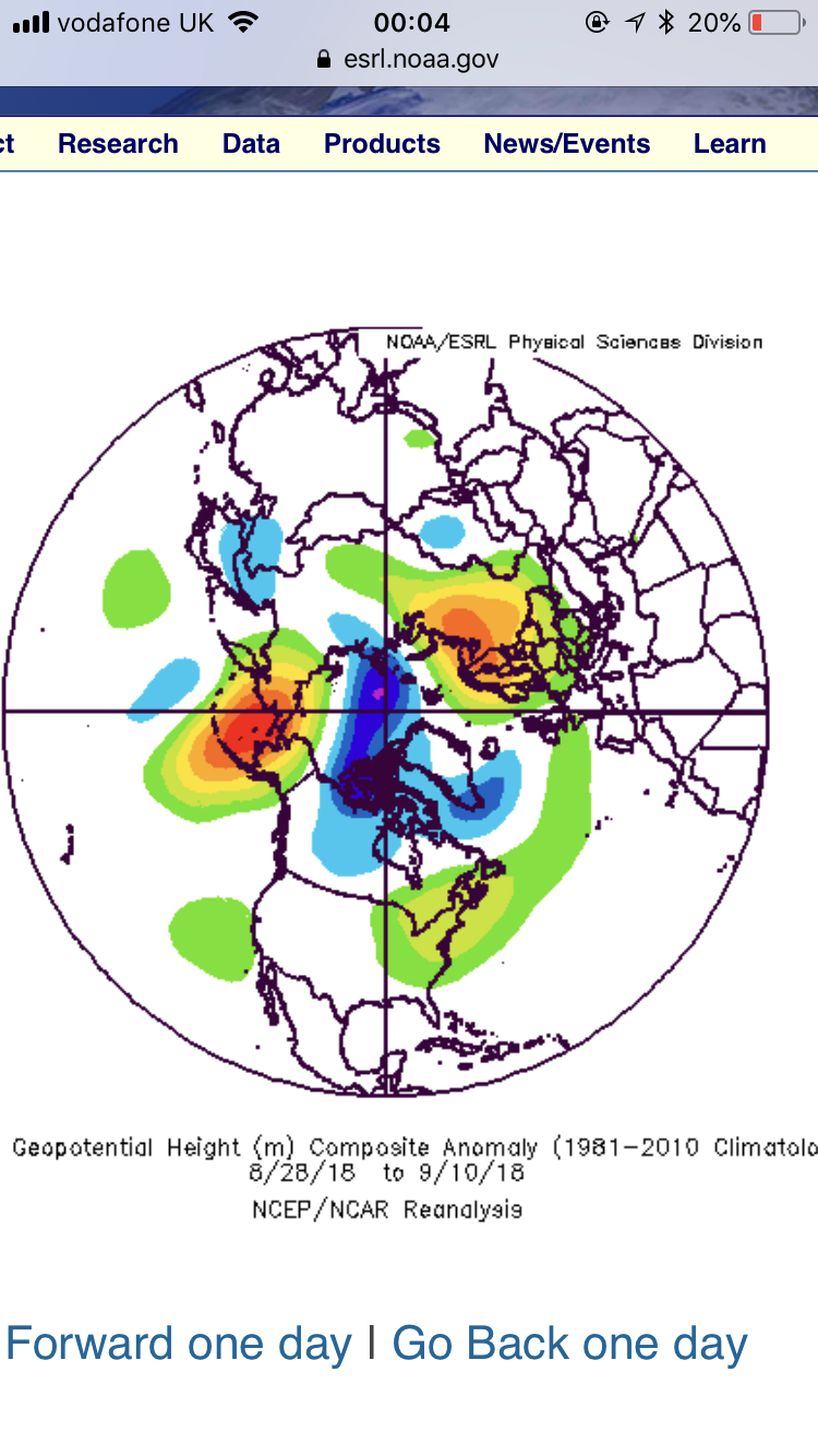
There is an Eastern Asian mountain torque event happening right now which will flip the pattern in north america that has persisted most of the summer and early autumn courtesy of pacific jet extension and a split jet at eastern side of north america. This may have subsequent effect on the Atlantic jet, unfortunately I am not skilled enough yet to predict what effect these EAMT events have on the long range circulation in our vicinity, for this I desperately need insight from likes of Tamara,GP,Lorenzo or Chionomaniac to explain it in layman terms, unfortunately non of them has posted for long time which is a pity.
Tamara still pops in from time to time, like myself. You might have a better chance of catching her here:
https://www.33andrain.com/topic/868-teleconnections-a-more-technical-discussion/
You were a tad early, but still largely right, with us now in a +EAMT event over the past few days. This as @Catacol states, we are in a +AAM phase, supported by the +EAMT and other torques. I don't expect the AAM to be very Nino-esque IMO, with SOI forecasts from the Met Office and ECMWF supporting a +SOI in Nov and Dec, supporting an atmospheric ENSO Nina-like phase. This would obviously translate to the AAM, and shows that there is potential for the Atmospheric ENSO component not to merge with Oceanic ENSO, which should be a weak-moderate basinwide event. This theoretically causes more NP-Jet extensions, which translates downstream to the UK, by methods of the GSDM. Context to this discussion here .
And the +EAMT is helping a Pacific Jetstream extension over the next 10 days, according to GFS.
-
7
-
-
This extract (minus a few changes for the UK) is from my latest post in my blog.
http://longrangesnowcenter.blogspot.com.au/2018/02/europe-on-long-term-26th-feb.html
"The GWO is currently in a negative trend. There are two options, the FT and MT torques increase, which will stabilise the GWO, like the below chart is starting to show. Or the other option is that the FT and MT torques go back to decreasing in a few days, and send the GWO into the low AAM Phases, which favours a +NAO setup. Many forecasters are favouring the latter option, so is the NWP guidance, but the former option is still a possibility with some torque data showing that to become reality. It will be interesting to see how that pans out.
EPS shows the MJO moving into Phase 2, before weakening into Phase 3. Phase 3 + 10 days equals a +NAO, or a more zonal Atlantic setup. This favours more snowfall for the Northern Alps/more precipitation for the UK, but GEFS shows the MJO weakening before it enters Phase 3.
EC46 like most models, is showing a big -NAO drop around the end of the month, that supports more cold for the UK. This -NAO pattern persists until mid March, and then stays mostly neutral into April. The ec46 AO forecast shows a similar result. CFS in a rare move, agrees with EC46 on both the AO and NAO.
GEFS and CFS longer term, show no signs of strengthening the polar vortex. The recent SSW is currently allowing a -AO/-NAO pattern to take hold until Mid March. The Stratosphere will probably play less influence after that time.
So the next 2-3 weeks will be guided by cold in Europe and the -NAO in the Atlantic. Beyond Mid March, we may see a +NAO setup start to form, under pressure from the AAM if it stays negative, and it may just generally occur also due to background factors like the sea-land gradient and the weakening yet still observable Nina base state."Here is the referenced chart of the EC46 NAO....
CFS as stated, looks very similar, which is interesting as it shows long term models agreeing on a forecast, that shows a higher degree of accuracy.
What we long term forecasters are looking to, is not the SSW driven medium term forecast, but the longer term one that is more likely to be centered around the Pacific.
-
8
-
-
1 hour ago, jmp223 said:
NAO lower today than it was a few days ago..increased connfidence of the cold pool remaining over the UK well into March
Hey mate, would you have a link to this forecast? Thanks.
1 hour ago, Glacier Point said:Away from the impending brutalness, are we about to see another high amplitude MJO wave develop ?
Currently quite a large convective signal across the Indian Ocean (different indices depicting different phase locations due to large aerial extent).
Surface and particularly sub-surface temperatures very conducive in the Western Pacific.
Rapid orbit into the higher aam states entirely feasible during March, with associated blocking signal persisting to the N/NE.
Do you really think that? Because all of the NWP guidance I have seen, shows the MJO in the COD by Early March. So I personally doubt any high amplitude MJO waves occur. This would plant the seeds for your higher AAM orbit in Later March.
-
1
-
-
- Popular Post
A quick update on the torques situation. MT is deeply negative, pushed by a low EAMT, creating the Pacific jet retraction that we are currently in. FT is steadily rising, generated from a WWB in the Pacific and a Kelvin wave in the IO, however it is still in the negatives. I did a whole tweet thread on that, if you are interested.
The current GWO situation brings the AAM near to zero, showing the transition from the +AAM orbit, that helped bring about the SSW, to the -AAM orbit that brings about the Pacific jet retraction. Shows how involved the AAM is....
GEFS currently shows MJO going into the COD on the 1st March in Phase 2.
This would help bring about a more +FT outlook, with the MJO signal weakening in the IO. This moves to +MT, etc....
The Pacific jet retraction isn't normally very helpful for the UK snow-wise. It normally forms with the -AAM state, to create a +NAO/ zonal setup. But in this case, the NAO is going to be deeply negative, thanks to the SSW. So the Pacific jet retraction is just a consequence of the drop in the AAM. As known, the GWO's orbit into the positive AAM stages help create the SSW, as part of the dual entity that the MJO and GWO are, but with their own individual identities.
Anyway my other opinion would be on my tweet thread up above. I am wishing you all bucketloads of snowfall and very cold temperatures across the UK (unless you don't like snowfall, then I guess stay next to the fireplace?)
-
7
-
7
-
- Popular Post
As known, the MJO is one of various reasons behind the SSW we are experiencing now (more of a influencer on extratropical patterns, but that's a story for another time). It's basically a GFS vs EC match ATM, with GFS with a stall and weakening sequence, and the EC with a more slow progression into P8&1. But longer term VP200 GFS is returning good for potential for P1&2. Apart from the benefits for Eastern troughing, this indicates a extratropical movement (to GWO p1&2), which could also improve longer term outlooks for Eastern America (First Week of March onwards...)
VP200 on GFS for preview.
EC Monthly and POAMA show a long period in the COD during the first half of March, so the prospects aren't great. But NWP is dicey, and anything could happen. And for that -AAM to occur, we really want a proper tropical lead, to bring MTs, et al down.
EC Monthly with a P7 stall and weaken, with a tight grip into the COD, and stalling as a very weak signal.
POAMA with a slower progression around P8&1 into the COD, although ending in the same conclusion as the ECMON.
Intriguing current GWO conditions, with a rapid increase in Worldwide MT over the past few days. This is based upon (mostly) increases in all MT regions, with EAMT increasing and now slightly decreasing, but it is still in the negative zone.
MT in the Andes and Rockies is positive and increasing, which is probably behind the spike in the MT.
The FT is currently in the negatives, and with MJO signalling in the IO we should see more of this. Then we should see the trop>extratrop link that Tamara and others are talking about, the +FT > +MT. This would be much more possible with a MJO propagation to the IO. The NWP is against this however, as shown above. Will the +MT be enough to convert the AAM to positives again? Will the NWP turn up correct, and we end up stuck in a -AAM phase? Only time can help. But keep up the interesting posts from all...
-
8
-
3
-
2 minutes ago, Glacier Point said:
Tropical forcing will get impacted by the strat warming - most likely will get suppressed. Additionally, we have the convective coupling moving towards the far western Indian Ocean, negative frictional torque territory. Put the two together, and the engine house for aam will go into slow speed. We've also been in a solid Nina state for some period, which will have imprinted on the atmosphere. So some reduction in overall aam and negative tendency look the best place to look. I wouldn't go for a big -AAM target, maybe -1SD max given likely westerly additions through 30N-40N.
Interestingly, the likely strat impacts in the high latitudes are best expressed through tropical analogues for African and West Indian Ocean convective centres. Some sense of choreography there ?
Aka MJO > Strat > MJO feedback loop. There's also the GWO in that equation, but it is harder to point out how it fits in.
I wouldn't say really solid Niña atmosphere, the SOI has been into Niño stages at times, and now the AAM has shown Niña the door. Once we get some Oceanic feedback, we can proceed further into knowing how that impacts the later stages of the year. Stepping stones....
I am certainly not going for a big -AAM at that stage. I will be awaiting this tropical -FT
-
1
-
1
-
-
- Popular Post
While some are using Niña composites, and drawing trends to a Niña base state, here and the specialist threads, plus Twitter, etc, it is important to point out that we are slowly leaving Niña. And the +AAM has shown us that the Niña base state is moving away, and we are heading to a more neutral state ENSO wise. While MJO driven, this in itself is going to be very important in the coming month. Are we going to see another +AAM orbit soon (end of Feb/early March)? Are we even going to go to P2&3 GWO? You can't always follow GEFS and the NWP models, you have to think outside of the box, and move with the times. Potential for GWO effects into Spring will be important for setting the stones into place for the UK summer, and ultimately next winter. But let's think less big, and think about the now. A little summary....
MJO is now apparently moving out of it's P7 stall. GEFS and GEPS want a continued stall, and weakening into COD, bypassing any P8 progression. EPS and JMA want a P8 and P1 progression slowly weakening to the COD. Interesting to see which one is successful, currently GEFS is one up, with it's correct prediction of a strong MJO signal stall in P7.
MT is currently slightly negative/mostly neutral, with an EAMT increase in difference with the trend over the past week, which saw a large negative tendency in the MT. This is causing a movement towards GWO Phase 8, as predicted.
(Latest GWO chart: 13th Feb)
With the Nina influence clearly waning, maybe we won't see a proper -AAM phase. A slower lead from FT, may be indicating a lesser -AAM stage, and a quicker return to +AAM territory. But for the interim, the SSW impacts should out-muscle the effects of the GWO for the time being, but the GWO is an important consideration going into March.
What that means for the UK, is a trickier task to point out, and I'll leave that to more regional members here. The SSW is a clear sign of the times, but what lurks beneath will point to the long term. Whatever that means to the reader, I will wonder. But for me, a variety of NWP and teleconnections is the way to go. Linking the two, and asking the big questions about the effects on each other is what it's all about.
-
10
-
4


.png.d423c9d3791e34bc3f1c780bc639f7fd.png)

.gif.3605c9ee5e38394dc9f4fdac30ced943.gif)


Model Discussion - Spring approaches - how warm at the end of this week?
in Forecast Model Discussion
Posted
Sorry I should have said with a 10 day lag, here you go:
https://www.ecmwf.int/sites/default/files/elibrary/2012/12942-prediction-madden-julian-oscillation-and-its-impact-european-weather-ecmwf-monthly-forecasts.pdf
Thanks for your comments above, those analogs are interesting, but I do believe the reality of the Nino event we have been through this season, kind of changes the definition, and ultimately is telling to watch the atmosphere is doing in terms of momentum transport and propagation, compared to using oceanic ENSO measurements.
Sorry to have to say the obvious, but I do go beyond that initial idea.