


Chevron12345
-
Posts
104 -
Joined
Content Type
Forums
Blogs
Gallery
Events
Learn About Weather and Meteorology
Community guides
Posts posted by Chevron12345
-
-
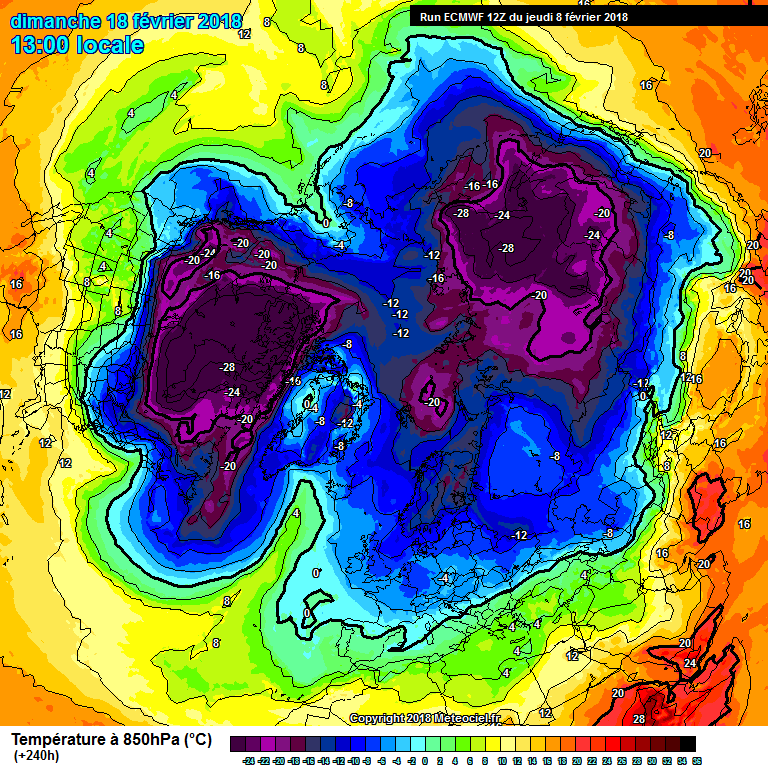
Has there been any response to the SSW anywhere? The PV just looks strong as normal with no change.
-
 1
1
-
-
So the QTR is well gone...are we actually seeing a SSW response? Even in FI? Is the UKMET easterly actually because of the SSW? Is the PV actually splitting and being destroyed? Genuine questions.
-
2 minutes ago, Daniel Smith said:
I'll be honest, 192 isn't exactly brilliant..

PV looks so dominant over Canada/Greenland - where is the SSW?
-
1
-
-
Full on winter at GFS 276 then full on spring at 348!!
-
43 minutes ago, Raythan said:
From days 6 into 7 the ECM is barely part of its own ensemble
Indeed, but the rest of the ensemble spread is not that exciting at all. I mentioned the mean the other day, and still nothing notable has changed.
-
13 minutes ago, knocker said:
It doesn't bear thinking about what if the low at the ecm day 10 slipped a tad south and warm air was advected over the UK from south east Europe?
No no..not an outcome that could ever be considered!!
-
20 minutes ago, TEITS said:
How on earth you can come to that conclusion is beyond me considering the vast differences we are currently seeing in the model output. May I ask why you are discounting what this mornings ECM is showing?
Comment related to 6z output. Thats what it showed. Maybe should of added: 'going by the 6z output...' Lots of panicing and jumping on posts again it seems.
-
22 minutes ago, mb018538 said:
Here is your culprit...
There has been a pool of very cold air stuck over NE Canada for ages...850s down to -40! This pours off the eastern seaboard, meets milder air from the south, tightens the thermal gradient, fires up the jet, and we are left with cold NW'erlies. Rinse and repeat.Indeed. Put perfectly. Seems that will be how February pans out unless something significant suddenly changes.
-
Just now, winterof79 said:
Thanks, but is there a link. Thanks kindly.
-
1 minute ago, ICE COLD said:
Can't stop looking at this peach of a chart . I just LOVE it ?.
Where can I get a closer look at the uppers on such a chart. Thanks.
-
1 minute ago, Frosty. said:
This is getting exciting from the Gfs 12z, the change could be starting in just over a week from now..lots more changes to come but the trend is lovely!!
Last pic shows the atlantic bashing through!!
-
1
-
-
8 minutes ago, frosty ground said:
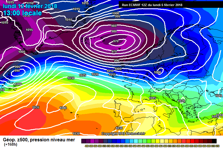
Hmmmmm Easterly (Not cold) but south East Europe is having an early spring.Can we have a greenland high please? Anything from the east is always on dodgy ground. Such a strong PV continually modelled over canada/greenland. Will the SSW nuke it...a split will just strengthen the lobe over that area...maybe (?). Atlantic looks strong, even the above chart has a LP system heading to the UK.
Edit...just seen a fat sausage entering greenland.
-
1 minute ago, Broadmayne blizzard said:
Bound to be a few variances on the effects of the ssw at the range especially with gfs coming out 4 times a day you're going to get every little nuance that only last only a few hours being picked up as a possible influence. At this range its the trend that is important and without doubt that trend is for northern blocking. Exact postioning and its effects for the UK won't be sorted for another week with any real accuracy.
There maybe northern blocking, but to my very untrained eye all I see is a big strong chunk of PV sat over Canada/Greenland sending weather systems off the Atlantic to the UK. Until that big chunk of PV does something else or disappears it just looks windy, wet with snow over high ground. Of course its not as simple as that due to the SSW, which I'm sure someone will point out. But if the SSW was not happening it just looks like good old english wintry weather, cold and damp down south and wintry in the the north.
-
1
-
-
GFS 6z, looks Atlantic dominated right through out. Lots of cold zonal air, usual places seeing wintry stuff. In the main pretty wet and windy.
-
 1
1
-
-
1 hour ago, Man With Beard said:
I see that we will start the 850s game should this easterly verify!!
My very oversimplified rule of thumb:
-10C 850s: should be snow for all
-8C 850s: snow for all on a SE/E/NEly except possibly extreme eastern coasts if there is a slack flow off the North Sea
-6C 850s from a E/NEly: mostly snow but possibly sleet for E coasts, or sleet more generally below 150m if the precipitation was light and the flow was very slack off the N Sea (this gives more time for sea air modification)
-6C 850s from a SEly: if the continent is under snow cover = snow for all. Otherwise, generally snow but sleety on the S coast.
-4C 850s from a E/NEly: rain on E coast, marginal below 150m, still snow on 150m-300m unless light precip and slack flow, snow above that.
-4C 850s from a SEly: rain/sleet on S coast unless the continent is very cold at surface level (more likely to be snow the more SE rather than SW). Inland, probably still snow but could be marginal if other factors not in favour.
-2C 850s from a E/NEly: generally rain unless a front cutting across cold air already in situ
-2C 850s from a SEly: could still be snow if continent is freezing and the flow is strong - otherwise rain unless a front cutting across cold air already in situ
I'm fully aware that other factors such as dew points are important but this kind of guide could be useful when the 850s are all we have to go by
Thats great...for snow falling. But 2m temps at around -5 wont mean freezing so any snow falling will just melt. Anyway not the place for that discussion.
-
6 minutes ago, tight isobar said:
Definate trend in the correct direction.
6z ens....
Only 2 just reach -10 for a very short time. Surely there should be some better (colder) upper air showing on those. -5 upper just won't cut the mustard with regard to 2m temperatures. You can see everyone complaining about the meto showing 5-6 for towns and cities come the last week of Feb!
-
1
-
-
1 minute ago, warrenb said:
Models will always try to revert to Zonal as that climatic norm. When a signal is so strong for blocking it often takes the model time to get there.
Why would it revert to zonal when, even with a SSW? Could you just explain the bit in bold..doesn't make sense? Thanks.
-
1 minute ago, Frosty. said:
At least it's generally cold zonal with just the occasional less cold / milder day..rather wintry at times for sure!
❄❄❄❄
Cold zonal indeed. But horrid wet, windy weather. This is certainly the theme for the foreseable...according to the current charts.
-
4
-
-
Over night min of -1 and -1.1 (two sensors).
Current temp 0.0 and 0.1
-
56 minutes ago, chionomaniac said:
The first signs of the SSW trop disturbances are there on the latest ECM 12Z by day 10 #arctichigh
That to me is the starting point.
Hasn't a artic high already been modelled in the later stages of output quite a few times already this winter? Why is that one different in relation to a SSW?
Edit - is it because of split pv?
-
1
-
-
1 minute ago, bluearmy said:
so we either believe the models and their ens that we will see strong zonal first part next week or we don't !
Guess we will need to until they show something different.
-
1
-
-
10 minutes ago, frosty ground said:
Bit of a runner between 144 and 168 that could be very wintry on the northern flank
Looking cold zonal Atlantic sourced wearther for a period. GFS also looked Atlantic influenced right into FI. Good for norhern areas and scotland.
-
1
-
-
3 minutes ago, fromey said:
@Chevron12345 I’m sorry but he SSW is not fantasy, it going to happen what we and others are not sure of is how it’s going to effect us, we could be the wrong side or it could pan out we end up going very cold.
looking at charts in to the future of how thing pans out is the fun of the chase especially when we have a SSW forecast.
i suggest reading Catcol and chio posts if you haven’t already
I have read all there posts, ok I will go with it...the SSW is nailed. But as you agree with me, the chances of a special event like 91 or other famous events over the years (Catcol named a few years) is beyond FI. Indeed will be interesting to see what happens in the models but many are counting on this producing the goods.
-
1 minute ago, Polar Bear said:
Unless you factor in the " rare" north easterly on top... and its feel factor Chevron?
. If it was the prevailing south westerly then the temps then may not be that cold really?. I flipping felt it this morning riding out first thing and I am out in all weathers every week.. thermals and about 10 layers. Lovely though. North Easterlies aren't that 'rare' -


.png.dc48735d23128b2596a92babf4973593.png)

 . If it was the prevailing south westerly then the temps then may not be that cold really?. I flipping felt it this morning riding out first thing and I am out in all weathers every week.. thermals and about 10 layers. Lovely though.
South West and Central Southern England Regional Weather Discussion 22/02/2018 Onwards
in Regional
Posted
-4 thismorning. Looking for something colder tomoz.